Mauritania
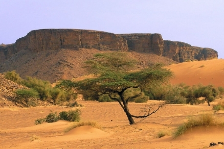
Mountains in the Adrar region of Mauritania. Source: Wikimedia Commons
Countries and Regions of the World Collection  Mauritania is a nation of three-and-a-third million people in northern-Africa, bordering the North Atlantic Ocean, between Senegal and Western Sahara.
Three quarters of the country is desert or semi desert; the mostly barren, flat plains of the Sahara Desert with some central hills.
|
|
|
|


Most of the population is concentrated in the coastal cities of Nouakchott and Nouadhibou and along the Senegal River in the southern part of the country
Mauritania's major environmental issues include:
- overgrazing, deforestation, and soil erosion aggravated by drought, which are contributing to desertification;
- limited natural fresh water resources away from the Senegal River, which is the only perennial river; and,
- locust infestation.
It is also susceptible to the hot, dry, dust/sand-laden sirocco wind which blows primarily in March and April; and, to periodic droughts.
Independent from France in 1960, Mauritania annexed the southern third of the former Spanish Sahara (now Western Sahara) in 1976, but relinquished it after three years of raids by the Polisario guerrilla front seeking independence for the territory.
Maaouya Ould Sid Ahmed Taya seized power in a coup in 1984 and ruled Mauritania with a heavy hand for over two decades.
A series of presidential elections that he held were widely seen as flawed. A bloodless coup in August 2005 deposed President Taya and ushered in a military council that oversaw a transition to democratic rule.
Independent candidate Sidi Ould Cheikh Abdallahi was inaugurated in April 2007 as Mauritania's first freely and fairly elected president. His term ended prematurely in August 2008 when a military junta led by General Mohamed Ould Abdel Aziz deposed him and ushered in a military council government. Aziz was subsequently elected president in July 2009 and sworn in the following month.
The country continues to experience ethnic tensions among its black population (Afro-Mauritanians) and white and black Moor (Arab-Berber) communities, and is having to confront a growing terrorism threat by al-Qa'ida in the Islamic Maghreb (AQIM).
Contents
Geography
Location: Northern Africa, bordering the North Atlantic Ocean, between Senegal and Western Sahara
Geographic Coordinates: 20 00 N, 12 00 W
Area: 1,030,700 km2 (1,030,400 km2 land and 300 km2 water)
arable land: 0.2%
permanent crops: 0.01%
other: 99.79% (2005)
Land Boundaries: 5,074 km. Border countries: Algeria 463 km, Mali 2,237 km, Senegal 813 km, Western Sahara 1,561 km
Coastline: 754 km
Maritime Claims:
territorial sea: 12 nm
contiguous zone: 24 nm
exclusive economic zone: 200 nm
continental shelf: 200 nm or to the edge of the continental margin
Natural Hazards: hot, dry, dust/sand-laden sirocco wind blows primarily in March and April; periodic droughts
Terrain: Mostly barren, flat plains of the Sahara Desert; some central hills. Its lowest point is Sebkhet Te-n-Dghamcha (-5 metres) and its highest point is Kediet Ijill (915 metres).
Climate: Desert; constantly hot, dry, dusty
|
Topography of Mauritania. Source: Wikimedia Commons |
Satellite view of Mauritania. Source: The Map Library |


Ecology and Biodiversity

Source: World Wildlife Fund
- Sahara desert
- North Saharan steppe and woodlands
- Saharan halophytics
- West Saharan montane xeric woodlands
- South Saharan steppe and woodlands
- Sahelian Acacia savanna
- Atlantic coastal desert
See also:
People and Society
Population: 3,359,185 (July 2012 est.)
Ethnic group: mixed Moor/black 40%, Moor 30%, black 30%
Age Structure:
0-14 years: 40.4% (male 665,314/female 660,352)
15-64 years: 56.2% (male 866,859/female 975,821)
65 years and over: 3.5% (male 48,075/female 65,213) (2011 est.)
Population Growth Rate: 2.323% (2012 est.)
Birth Rate: 32.78 births/1,000 population (2012 est.)
Death Rate: 8.66 deaths/1,000 population (July 2012 est.)
Net Migration Rate: -0.89 migrant(s)/1,000 population (2012 est.)
Life Expectancy: 61.53 years
male: 59.3 years
female: 63.82 years (2012 est.)
Total Fertility Rate: 4.22 children born/woman (2012 est.)
Languages: Arabic (official and national), Pulaar, Soninke, Wolof (all national languages), French, Hassaniya
Literacy(2000 census): 51.2% (male: 59.5% - female: 43.4%)
Urbanization: 41% of total population (2010) groweing at a 2.9% annual rate of change (2010-15 est.)
History
At the crossroads of the Arab North and sub-Saharan Africa, Mauritania is a vast but sparsely populated country of some 3 million inhabitants whose capital Nouakchott (population: approximately 1 million) is on the Atlantic coast of Africa. Ancient cities in the interior were important Saharan trade centers from the Ghana Empire through the expansion of Arab civilization and into modern times. The largest of these, Chinguetti, is the seventh-holiest site in Islam.
European colonization came relatively late to Mauritania, which at its independence from France in 1960 was still administered from St. Louis, Senegal. Today’s capital, Nouakchott, was a small outpost midway between that city and Port Etienne, now called Nouadhibou, Mauritania’s commercial capital.
At independence, much of the country’s population followed a nomadic lifestyle or worked in agriculture in remote areas mostly untouched by colonial administration. Traditional slavery was formally abolished in 1980. As a result of centuries of this practice, Mauritanian society is characterized by former slave-owning groups of Arab-Berber origin, known as White Moors, and the Black Moor descendants of their liberated slaves who generally lived in the northern and eastern regions. Black African communities, also marked by slavery, traditionally resided in the southern part of the country near the Senegal River.
Ethnic tensions persist in Mauritania. In April 1989 violence broke out between communities, stemming from a schism between Arab-Berber and Black African communities. Over the next 2 years the “1989 events" resulted in Mauritania's deportation of Black African citizens to Senegal and Mali, state-sponsored killings, and the purge of tens of thousands of Black Africans from the military and government and their expulsion. In 2010, the UN High Commissioner for Refugees concluded its program of repatriating Mauritanian citizens from Senegal, a significant milestone in Mauritania’s efforts to resolve this decades-long refugee problem, also known as the passif humanitaire.
Mauritania’s first President, Moctar Ould Daddah, served from independence through 1978. A series of coups brought Maaouya Ould Sidi Ahmed Taya to power, where he remained until removed from office in a 2005 bloodless coup d’etat. Elections in 2007 gave Mauritania a civilian head of state, Sidi Mohamed Ould Cheikh Abdallahi, briefly making the country an international model of a peaceful transition to democracy.
In August 2008, General Mohamed Ould Abdel Aziz led another bloodless coup d’etat; he had opposed an Islamist-inspired coup against Taya in 2003, but supported the 2005 removal. International mediation resulted in the Dakar Accord of June 2009, and elections recognized by the international community were held in July of that year. President Aziz, running as a civilian candidate, won with 53% in the first round against a divided opposition.
Municipal and parliamentary elections, previously scheduled for September and October 2011 have been postponed, and President Aziz’s 5-year term will expire in 2014. In May 2011, President Aziz publicly launched a new system to conduct a census, automate national identity documents, and finalize the voter list. Civil society has raised concerns that its technical implementation will lead to disenfranchisement of Black Moors and Black African citizens. Although no recent census exists, it is estimated that 30% of the population are White Moors. Another 40% of mixed Arab-Berber-Black African descent are Black Moors. The remaining 30% are Black Africans of the Soninke, Pulaar, and Wolof tribes. Almost all Mauritanian citizens are Muslim.
Al Qaeda in the Islamic Maghreb (AQIM) traditionally has operated in Algeria and northern Mali and has recruited and trained extremists from Tunisia, Morocco, Nigeria, Mauritania, Libya, and other countries. Mauritania has taken an aggressive stance against terrorism, which remains a threat in the country. For several years, AQIM has carried out attacks against official targets and Westerners in Mauritania. In the late 2000s, European tourists were kidnapped and murdered by AQIM operatives. In 2011, Mauritanian courts convicted three individuals for the murder of an American citizen 2 years earlier.
Government
Government Type: Democratic Republic
Mauritania is a presidential republic. The government bureaucracy is composed of ministries, special agencies, and parastatal companies. The Ministry of Interior controls a system of regional governors and prefects modeled on the French system of local administration. Under this system, Mauritania is divided into 13 regions (wilaya), including the capital district, Nouakchott. Control is tightly concentrated in the executive branch of the central government, but a series of national and municipal elections since 1992 have produced some decentralization, and efforts to decentralize the government continue.
Mauritania’s bicameral legislature is composed of the lower house (National Assembly) directly elected to a 5-year term through universal suffrage, and the upper house (Senate) whose members are elected to 6-year terms by municipal councilors. The last elections for the National Assembly and Senate were held in 2006 and 2009, respectively.
Capital: Nouakchott - 709,000 (2009)
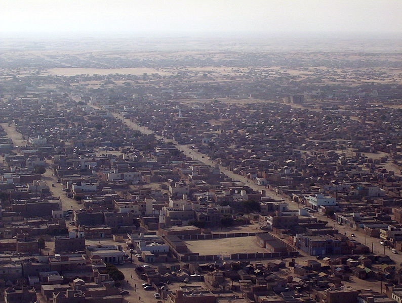
Nouakchott. Source: Wikimedia Commons.
|
Administrative divisions: 13 regions (wilayas, singular - wilaya);
|
Source: Wikimedia Commons |

Independence Date: 28 November 1960 (from France)
Legal System: a combination of Islamic law and French civil law; has not accepted compulsory ICJ jurisdiction
Suffrage: 18 years of age; universal
International Environmental Agreements
Mauritania is party to international agreements on: Biodiversity, Climate Change, Climate Change-Kyoto Protocol, Desertification, Endangered Species, Hazardous Wastes, Law of the Sea, Ozone Layer Protection, Ship Pollution, Wetlands, and Whaling.
Water
Total Renewable Water Resources: 11.4 cu km (1997)
Freshwater Withdrawal: Total: 1.7 cu km/yr (9% domestic, 3% industrial, 88% agricultural).
Per capita Freshwater Withdrawal: : 554 cu m/yr (2000)
Access to improved sources of drinking water: 49% of population
Access to improved sanitation facilities: 26% of population
Agricultural
Agricultural Products: dates, millet, sorghum, rice, corn; cattle, sheep
Irrigated Land: 490 sq km (2002)
Resources
Natural Resources: iron ore, gypsum, copper, phosphate, diamonds, gold, oil, fish.
Energy
| Energy in Mauritania | |||||
| Production | Consumption | Exports | Imports | Reserves | |
| Electricity | 547 million kWh (2008 est.) |
508.7 million kWh (2008 est.) |
0 kWh (2009 est.) |
0 kWh (2009 est.) |
|
| Oil | 11,640 bbl/day (2010 est.) |
20,000 bbl/day (2010 est.) |
10,000 bbl/day (2009 est.) |
17,750 bbl/day (2009 est.) |
100 million bbl (1 January 2011 est.) |
| Natural Gas | 0 cu m (2009 est.) |
0 cu m (2009 est.) |
0 cu m (2009 est.) |
0 cu m (2009 est.) |
28.32 billion cu m (1 January 2011 est.) |
| Source: CIA Factbook | |||||
Economy
Mauritania remains among the world’s poorest countries, ranked 136th of 169 countries in the United Nations Human Development Index in 2010. In 2010, the Mauritanian economy grew by an estimated 4.7%, compared to a contraction of 1.2% in 2009, and GDP was an estimated $3.799 billion. Donors have pledged future support, with approximately 70% from non-Western sources, especially Arab states. Some 88% of the 2011 budget of 269 billion ouguiya (or $928 million) is to come from internally-generated revenue, which is up considerably thanks to more careful stewardship, and the remainder from donors. About 17% of the budget is devoted to national security; another 17% is slated for education, followed by transportation at 4%.
In a country that imports some 70% of its food, rising world prices for staple commodities could cause great hardship, especially for the urban poor. In rural areas, the harvest was quite good in 2011, but management of food stocks is frequently inadequate. Malnutrition is on the rise in some rural areas, including in the area affected by an outbreak of Rift Valley Fever in late 2010. Drought, disease, and locusts could destroy much of 2011's crops and livestock.
Demographically, Mauritania is young, with 70% of the population under the age of 29. Unemployment runs at 32%. The government has made recent efforts to support training in technical fields with a focus on youth. President Aziz campaigned as the “President of the Poor,” vowing to stop the rampant corruption and serious abuses that characterized the past 30 years of Mauritania’s history. Key infrastructure projects such as the Aftout es-Saheli pipeline to bring water from the Senegal River to Nouakchott, which came on line in October 2010, have accelerated under his leadership, as have efforts to interest international investors in iron and gold mining as well as petroleum and, to a lesser extent, wind and solar power.
Half the population still depends on agriculture and livestock for a livelihood, even though many of the nomads and subsistence farmers were forced into the cities by recurrent droughts in the 1970s and 1980s.
Mauritania has extensive deposits of iron ore, which account for nearly 40% of total exports. The nation's coastal waters are among the richest fishing areas in the world but overexploitation by foreigners threatens this key source of revenue.
The country's first deepwater port opened near Nouakchott in 1986.
Before 2000, drought and economic mismanagement resulted in a buildup of foreign debt. In February 2000, Mauritania qualified for debt relief under the Heavily Indebted Poor Countries (HIPC) initiative and nearly all of its foreign debt has since been forgiven. A new investment code approved in December 2001 improved the opportunities for direct foreign investment. Mauritania and the IMF agreed to a three-year Poverty Reduction and Growth Facility (PRGF) arrangement in 2006. Mauritania made satisfactory progress, but the IMF, World Bank, and other international actors suspended assistance and investment in Mauritania after the August 2008 coup. Since the presidential election in July 2009, donors have resumed assistance.
Oil prospects, while initially promising, have largely failed to materialize, and the government has placed a priority on attracting private investment to spur economic growth. The Government also emphasizes reduction of poverty, improvement of health and education, and privatization of the economy. Economic growth remained above 5% in 2010-11, mostly because of rising prices of gold, copper, iron ore, and oil.
GDP (Purchasing Power Parity): $7.242 billion (2011 est.)
GDP (Official Exchange Rate): $4 billion (2011 est.)
GDP- per capita (PPP): $2,200 (2011 est.
GDP- composition by sector:
agriculture: 19.2%
industry: 36.6%
services: 44.1% (2011 est.
Population Below Poverty Line: 40% (2004 est.)
Industries: fish processing, mining of iron ore and gypsum
Exports: iron ore, fish and fish products, gold
Export Partners: China 33.1%, France 9.1%, Italy 8.2%, Spain 8.2%, Japan 5.3%, Netherlands 5.1%, Belgium 4.8%, Cote d'Ivoire4.6% (2006)
Imports: machinery and equipment, petroleum products, capital goods, foodstuffs, consumer goods
Import Partners: France 16.6%, China 8.4%, Spain 6.7%, US 6.1%, Belgium 5.8%, Brazil 5.4% (2006)
Economic Aid Recipient: $190.4 million (2005)
Currency: ouguiya (MRO)
Ports and Terminals: Nouadhibou, Nouakchott

The so-called Richat Structure, center right in this false-color satellite image, is a geological formation in the Maur Adrar Desert. Compare this image to the true-color photo taken from a spacecraft. Although it resembles an impact crater, the Richat Structure formed when a volcanic dome hardened and gradually eroded, exposing the onion-like layers of rock. Image courtesy of USGS.

The Richat Structure, a prominent circular feature in the Sahara Desert of Mauritania, has attracted attention since the earliest space missions because it forms a conspicuous bull's-eye in the otherwise rather featureless expanse of the Gres de Chinguetti Plateau in central Mauritania. The Structure, which has a diameter of almost 50 km (30 mi), has become a landmark for space shuttle crews. Initially interpreted as a meteorite impact structure, it is now thought to be merely a symmetrical uplift (circular anticline) laid bare by erosion. Image courtesy of NASA.