Water profile of Uganda
Contents
- 1 Geography, Climate, and Population
- 2 Economy, Agriculture, and Food Security
- 3 Water Resources and Use
- 4 Irrigation and Drainage Development
- 5 Water Management, Policies, and Legislation Related to Water Use in Agriculture
- 6 Environment and Health
- 7 Perspectives for Agricultural Water Management
- 8 Further Reading
Geography, Climate, and Population
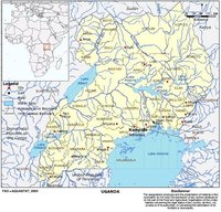
Uganda (1°00' North, 32°00' East) is a landlocked country located at the equator between 4° North and 1° South and stretching from 29.5° to 35.5° East. It has a total area of 241,040 square kilometers (km2), a north-south extent of about 650 kilometers (km) and a maximum east-west extent of about 500 km. The country borders Sudan to the north, Kenya to the east, the United Republic of Tanzania and Rwanda to the south, and the Democratic Republic of the Congo to the west. Much of the country lies at an altitude of 900 to 1,500 meters (m), with an average altitude of 1,200 m. About 18 percent of the total area of the country is open water, and large areas are covered by swamps. The highest mountains of the country are Mount Stanley, 5,109 m at the border with the Democratic Republic of Congo followed by Mount Elgon, 4,321 m at the border with Kenya.
In the south the characteristic scenery consists of flat-topped mesa-like hills and broad intervening valleys frequently containing swamps, while in the north the landscape is more subdued, consisting of gently rolling open plains interrupted by occasional hills, mountains, and inselbergs. In the south-west, broken hill country, encircling lowland embayments, forms the transition to the deeply incised plateau that reaches its greatest elevations of over 2,000 m above sea level in the Kabale district.
The country is underlain by some of the world’s oldest rocks, which have been modified by deep-seated mountain-building activity. These rocks are overlain by predominantly ferrallitic, and to a lesser extent ferruginous, soils as the most widely distributed soil type, occurring in both forest and savannah ecosystems in the country. The profile of these soils consists of a thin (20-30 centimeters (cm)) topsoil and a deep (5-10 m) subsoil. Organic matter and nutrients are strongly concentrated in the topsoil. These soils range in texture from clay loams to sandy loams, although red clay loams tend to predominate in the wetter regions.
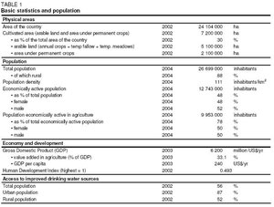
The cultivable area was estimated to be 16.8 million hectares (ha) in 1991. In 2002, the cultivated area was 7.2 million ha, of which 5.1 million ha arable land and 2.1 million ha under permanent crops (Table 1).
The country can be subdivided into 4 major agro-ecological zones:
- High altitude zone in Kigezi, Sebel, parts of Ankole, west Nile, Toro, Mbale; temperate-zone crops
- Pastoral dry to semi-arid range lands in east Ankole, west Masaka, Karamoja; pastoral systems
- Northern and eastern short grasslands zone; short grasslands and cotton-finger millet mixed farming systems
- Southern and western tall grasslands zone; tall-grass areas, perennial and annual crops in mixed farming systems
Uganda has an equatorial climate with small regional variations in annual temperature and humidity. Precipitation varies from 750 millimeters per year (mm/yr) in the Karamajong pastoral areas in the northeast to 1,500 mm/yr in the high rainfall areas on the shores of Lake Victoria, around the highlands of Mount Elgon in the east, the Ruwenzori Mountains in the southwest, Masindi in the west, and Gulu in the north. Mean annual rainfall is estimated at 1,180 mm. The southern part of the country is generally well-watered with two rainfall peaks occurring in March-May and August-November without any pronounced dry season in between, whereas in the north there is a marked dry season from November to March. Seasonal and spatial variability of precipitation causes specific problems as the country encompasses both humid and semi-arid areas. There are not only differences between distinct wet and dry years, but there are also considerable variations in the timing of the onset of seasons and in the amount of rainfall and hence stream flow. Even in the high rainfall areas around Lake Victoria there is a moisture deficit during the periods December-February and June-September. The mean annual temperature over most of the country is in the range of 18 degrees Celsius (°C) to 35 °C, while the corresponding minimum range is 8 °C to 23 °C. Relative humidity is high, ranging between 70 percent and 100 percent and the mean monthly evaporation rates are between 125 and 200 millimeters (mm).
The total population of the country is estimated at 26.7 million (2004), of which 88 percent are rural (Table 1). The annual population growth rate is 2.8 percent. The national average population density is 111 inhabitants/km2, with a range from 8 to 157 persons/km2. About 54 percent of the population is concentrated on the shores of Lake Victoria and in the southern part of the country.
Poverty is mainly a rural phenomenon where 48 percent of the rural population live below the poverty line, while in urban areas 16 percent are estimated to be living below the poverty line. Poverty was successfully reduced from 44 percent in 1997-1998 to 35 percent in 1999-2000 and statistics reveal that the main determinant in the reduction of poverty in rural areas of Uganda has been the ability to produce and market traditional cash crops. However, there are regional imbalances; poverty has decreased by 43 percent in urban areas but only by 18 percent in rural areas since 1992 and in the northern region the proportion of the population in poverty rose from 61 percent to 67 percent between the period 1997-1998 and 1999-2000, despite the overall national reduction in poverty. Poverty eradication is a fundamental objective of Uganda’s development strategy, in which the Government has resolved to reduce the proportion of the population living in absolute poverty to 10 percent by the year 2017. In 2002, 87 percent of the urban and 52 percent of the rural population were using improved drinking water sources (Table 1).
Economy, Agriculture, and Food Security
The gross domestic product (GDP) of Uganda was US$6.2 billion in 2003, and the value added by agriculture was 33.1 percent of GDP. Agriculture provides occupation for almost 10 million people, which is 78 percent of the total economically active population. Male and female workers represent 50 percent each of the population working in agriculture. Agriculture dominates the Ugandan economy and has supplied almost all of Uganda’s exports in recent years. Ugandan agriculture is largely dependent on small-scale and medium-scale farmers with average land holdings of 2.5 ha.
The main food crops are bananas (matoke), with 28 percent of cropped areas in 2000, cereals (maize, rice) (25 percent), root crops (17 percent), pulses (14 percent), oil seeds (8 percent), vegetables, and fruits; export crops (coffee, cotton, vegetable, fruits, cocoa, vanilla, sugar cane, tea, and flowers) account for 8 percent. The most important agricultural export crop is coffee with US$296 million in 1998, while the total agricultural export was US$536.5 million in the same year. As an example of non-traditional exports, 6,000 tonnes (t) of exported flowers earned the country foreign exchange of US$23 million in 2003.
Although Uganda had an overall positive food balance in the past, per capita food production has declined mainly because of a rapid population growth and because of the conflicts in the north and northeastern parts of the country. The growth rate in food production, estimated at 1.5 percent, cannot cope with these circumstances and in response the Government has continued to import food, such as 4,000 tonnes of rice/year. The Government has developed a master plan on poverty eradication, with the "Plan for Modernization of Agriculture" of 2000 being one of its core components. In the plan, rice production is seen as a key to food security and increased household income.
Much of the banana crops, particularly in relatively high rainfall areas, still enjoy in-situ water harvesting techniques in crop management as opposed to irrigated agriculture. Coffee farmers, similarly, belong to the same trend although pilot demonstrations have shown that irrigation of clonal coffee can be a viable option. Tea estates enjoy the benefits of the highland area climate while much of the sugar cane is produced under wetland conditions. Crops like cassava, sweet potatoes, millet, sorghum, etc. have continued to be grown under rainfed conditions due to their high resistance to drought and low value categorization. In some instances, short-term varieties are being developed by the National Agricultural Research Organization (NARO) to cope with the shorter duration of rainfall.
Although Human Immunodeficiency Virus/Acquired Immune Deficiency Syndrome (HIV/AIDS) is still a critical development problem, Uganda has made significant progress in reducing its prevalence from 14 percent in 1995 to 6.1 percent in 2000. The prevalence of HIV/AIDS in agricultural production has had effects in the districts of Rakai and partially Masaka where most of the families are child-headed. The impact is in the form of the loss of skilled and unskilled labor that would otherwise be engaged in production, research, extension service, and in policy formulation and implementation. However, its impact in other parts of the country has been curbed by effective Government policy. Under this strategy, the Ministry of Agriculture, Animal Industry and Fisheries, has a well-funded and articulated project aimed specifically at sensitization and health education at all levels, beginning from the Entebbe Headquarters’ staff. The campaign is to supplement the efforts of the Ministry of Health and the non-governmental organizations (NGOs).
Water Resources and Use
Water Resources
The Nile Basin constitutes about 98 percent of the total area of the country, while a fringe of about 4,500 km2 along the country’s border with Kenya belongs to the Rift Valley Basin.
The Ugandan part of the Nile Basin shares a large part of the extensive interconnected system of the Equatorial lakes that forms the upper part of the White Nile. Lake Victoria, which drains a total area of about 184,000 km2 in Rwanda, Burundi, the United Republic of Tanzania, Kenya, and the entire southern part of Uganda, has its outlet at Jinja. Passing the Owen Falls Dam, the water flows through the Victoria Nile into Lake Kyoga and subsequently into the northern end of Lake Albert. The other branch of the Lake system (i.e. Lake George and Lake Edward) is connected via the Semliki River, which flows into the southern end of Lake Albert. From Lake Albert, the Albert Nile flows northwards towards Sudan.
The Ugandan Nile Basin is for operational purposes divided into eight sub-basins, which are relatively small contributors to the Nile flow, but their yields dominate the water resources potential within Uganda. While the Nile and its flow characteristics are important from both an international and national point of view, the Ugandan catchments are important from a district and local point of view. The eight sub-basins are: Lake Victoria Basin, Lake Kyoga Basin, Victoria Nile Basin, Lake Edward Basin, Lake Albert Basin, Albert Nile Basin, Achwa Basin and Kidepo Basin.
Productive aquifers are mainly found in the weathered bedrock layer overlying the crystalline basement rock, and in faults and fractures in the basement. In mountain areas, however, aquifers occur in volcanic formations and groundwater occurrence is often in the form of springs.
Uganda’s wetlands are widespread and complex. About 10 percent of the country, or approximately 24,000 km2, is covered by wetlands (swamps), of which about one-third is permanently flooded. In the south and west of the country, they form an extensive low-gradient drainage system in steep V-shaped valley bottoms with a permanent wetland core and relatively narrow seasonal wetland edges. In the north, they mainly consist of broad flood plains. In the east, they exist as a network of small, vegetated valley bottoms in a slightly undulating landscape. Wetlands may reduce the effects of both floods and droughts, provide fish resources and support cropping and grazing along their margins, and they are centers of high biodiversity and productivity as well as valuable refuges and sources of food for fish. Furthermore, they are active biological filters in the treatment of effluents, but due to this function they are also sensitive to the accumulation of pollution.
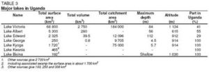
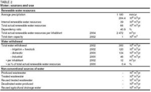
Internal surface water resources (IRWR) are estimated to be 39 cubic kilometers per year (km3/yr), while groundwater is believed to be around 29 km3/yr, but all of this is considered to be overlap between surface water and groundwater, keeping the total IRWR at 39 km3/yr (Table 2). External resources of 27 km3/yr comprise inflow from Lake Victoria (25 km3/yr) as well as inflow via Lake Edward and Lake Albert from the Democratic Republic of Congo. The total renewable water resources of the country are estimated to be 66 km3/yr. The potential yield from deep aquifers is above 3 cubic meters per hour (m3/hr) in the southwest, southeast, northwest, and along the eastern border of the country. In large areas of the central parts of the country potential yields are between 2 and 3 m3/hr, while in some areas it is below 1 m3/hr. The major lakes in Uganda are given in Table 3.
Apart from the major lakes, there are over 160 minor water bodies, covering 1,707 km2. There are also over 1,000 dams and valley tanks for both aquaculture and livestock watering. The Government currently carries out a program to construct valley tanks, and by the beginning of 2004, 30 out of the planned 50 of these surface water reservoirs in 6 districts had been completed.
The Owen Falls Dam is located at the outlet of Lake Victoria. Completed in 1954, it had an installed hydropower capacity of 180 megawatts (MW), which has recently been extended by 90 MW. The construction of the 250 MW Bujagali hydropower plant near Jinja, about 8 km north of Lake Victoria, began in January 2003. Its reservoir will have a capacity of 750,000 m3. Other projected schemes located along the Nile downstream of Owen Falls include Ayago (240/300 MW) and Murchison (600 MW).
Water Use
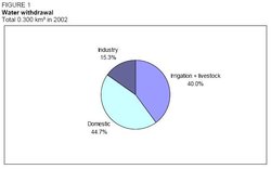
Total water withdrawal of the country was 300 million m3 in 2002, representing 0.4 percent of total renewable water resources (Table 2). The greatest water user was the domestic sector with 134 million m3, followed by irrigation and livestock with 120 million m3, and industry with 46 million m3 (Figure 1).
Groundwater represents the main source of domestic water supply for the rural population of Uganda. It is also important for livestock use particularly in the drier regions. Groundwater extraction takes place from springs, boreholes, and, to a lesser extent, from hand dug wells. Surveys have identified some 12,000 springs in Uganda, of which more than 4,500 have been developed and protected for safe use. About 9,000 boreholes, typically drilled to a depth of 60 to 90 meters, are equipped with hand pumps. Rates of actual extraction are low and most boreholes are fitted with handpumps with capacities between 0.6 and 1.2 m3/hr depending on the pumping head.
International Water Issues
The Nile Basin States have taken initiatives towards reaching and concluding a River Basin Cooperative Framework Agreement, so as to achieve sustainable socioeconomic development through an equitable utilization of and benefit from the common Nile River Basin water resources. While the agreement is still in a draft form, the Nile Basin States at the meeting of their Council of Ministers held in the United Republic of Tanzania in February 1999 established the "Nile Basin Initiative" (NBI), whose headquarters are at Entebbe, pending the conclusion of the agreement. In February 2002 in Egypt, the Council of Ministers decided that the Nile Basin Initiative should enjoy a legal personality in the territory of each Nile Basin state. In terms of the institutional framework and regulation, the Nile Basin Initiative is vital for large-scale projects utilizing Nile River water.
Irrigation and Drainage Development
Evolution of Irrigation Development
Past estimates of irrigation potential varied between about 200,000 and 400,000 ha, with the largest potential areas in the Lake Kyoga catchment, the Western Region, the Albert Nile Valley, and in the Jinja and Iganga districts on Lake Victoria in the southeast of the country. In contrast to the areas defined in the past, the latest study in 2003 identified only 90,000 ha of irrigation potential.
Small-scale informal irrigation has been practiced in Uganda since the 1940s. The majority of the irrigated areas are located on the fringes of swamps. Smallholder irrigation is considered ‘informal irrigation’ as smallholders developed it spontaneously without planning and with little or no technical assistance; often the technology used is basic and sometimes inappropriate.
Formal irrigation development in the country commenced in the 1960s with the following schemes:
- The Mubuku irrigation settlement scheme in the Kasese District was established as a settlement scheme with gravity irrigation and water intakes from Sebwe and Mubuku rivers. Its command area was 600 ha, of which 430 ha were irrigated in 1998.
- The Kiige scheme in the Kamuli District has Lake Nabigaga as a water source for sprinkler irrigation of citrus fruits. Its command area was 150 ha, of which 10 ha were irrigated in 1998.
- The Labori and Odina schemes were abstracting water from Lake Kyoga for sprinkler irrigation; the Labori scheme, in the Soroti District, had a command area of 40 ha but by 1998 no irrigation took place.
- The Ongom scheme in the Lira District is a sprinkler irrigation scheme for citrus fruits with water from a reservoir of 4,500 m3 capacity. The scheme had a command area of 40 ha, of which 10 ha were irrigated in 1998.
- The Atera irrigation scheme in the Apac District was designed to abstract water from the Nile River through pumping and subsequent gravitational flow through pipes and water hydrants to the fields. The scheme had a command area of 20 ha but by 1998 no irrigation took place.
- The Agoro self-help irrigation project in the Kitgum District is a gravity-fed scheme with intake from the Agoro River. All of its 120 ha command area was irrigated in 1998.
In the 1970s the Chinese initiated the development of rice schemes, with the Kibimba rice scheme as a rice technology development scheme and the Doho rice scheme for seed multiplication and popularization of production. The Kibimba scheme is in the Iganga District and has a command area of 600 ha, all of which was irrigated by 1998. The Doho scheme in the Tororo District has a command area of 1,000 ha, all of which was irrigated by 1998. Floriculture private-sector farmers started green houses concentrated in the Lake Victoria area in the 1990s. The latest Government-constructed and -implemented scheme, the Olweny swamp rice irrigation project with a command area of 50 ha, went into operation in 1997 (nucleus site) and 2001 (Itek and Okile).
The progress with formal irrigation has been very slow and with limited success. One reason is the top-down approach adopted in most schemes. The farmer-based schemes of Mubuku, Doho, and Agoro were considerably more successful. On the other hand, informal small-scale irrigation has been increasing, especially for rice, vegetable, and fruit production. The increased area of informal rice production is a result of technology adoption from the Chinese in the Kibimba Rice Scheme. Informal small-scale irrigation is practiced mostly in the southeast of the country. Currently, a Food and Agriculture Organization (FAO) pilot project is adopting a bottom:up approach at 7 small-scale irrigation sites with an area of about 36 ha and about 100 farmers.
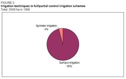
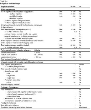
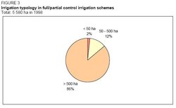
In 1998 the area equipped for irrigation was 5,580 ha, most of which is located in the southeast part of the country in the districts between Lake Victoria and Lake Kyoga (Table 4). Of this, 2,330 ha were actually irrigated. Surface irrigation is the main irrigation technique, while 230 ha are equipped for sprinkler irrigation and localized irrigation is practiced at a pilot-scale at three sites (Figure 2). Large schemes (>500 ha) dominate the sector with 4,800 ha equipped, medium schemes account for 680 ha and small schemes (<50 ha) for 100 ha (Table 4 and Figure 3). Surface water is almost exclusively used as water source. In 1998, about 53,350 ha of fringes of swamps were cultivated, of which 3,570 ha were equipped in 1987.
Role of Irrigation in Agricultural Production, the Economy, and Society
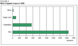
In 1998, 2,220 ha of the equipped area of 2,620 ha of formal schemes were actually irrigated, of which 1,650 ha of rice, 430 ha of vegetables, 120 ha of mixed rice and vegetables, and 20 ha of citrus fruits (Table 4 and Figure 4). Of the 2,960 ha equipped area of commercial schemes, only 110 ha were irrigated, of which 100 ha sugar cane and 10 ha mixed vegetables-cotton-sugar cane-maize-rice. High value crops such as flowers are being grown under irrigation for export but only to a limited extent and within a restricted area close to export gateways. In informal schemes in the wetlands mainly rice, but also green maize, some vegetables, and other cash crops are grown.
The Mubuku irrigation scheme is considered the food basket for the Kasese district. This is because, in addition to the provision of employment, farmers from different highly populated districts moved to settle in the scheme. The scheme also acts as a seed multiplication center for maize, soybeans, and groundnuts. It has currently accessed European markets for the export of okra and French beans in addition to supplying the tomato sauce factory in Kasese with raw materials (tomatoes and papayas). The Kibimba rice scheme (private sector) provides work for to the surrounding community while the Doho rice scheme has substantially raised the standard of living of its farmers. This is demonstrated by the sprouting of permanent buildings, rice milling machines, and changed eating habits of the farmers coupled with the education of children. Rice from Doho finds its way to Rwanda and occasionally to the Democratic Republic of Congo.
For small-scale (1-4 ha) systems it was found that for all crops, gross margins from treadle pump technology are higher than the gross margins under rainfed cultivation. In the case of motorized pumps with surface irrigation, gross margins for coffee, maize, beans, cassava, and bananas are less than the gross margins under rainfed cultivation. However, under motorized pumps with sprinkler irrigation, all crops except coffee, cassava, and bananas (rice is not considered for irrigation under sprinklers) gave higher gross margins. In all three cases of supplementary irrigation technologies, tomatoes, onions, and rice give distinctly increased gross margins compared to rainfed cultivation. Preliminary results from the introduction of supplementary irrigation to clonal coffee show an annual yield of 5.6 tonnes per hectare (t/ha) of green coffee. This is more than twice the 2.5 tonnes/ha yield obtained before introducing supplementary irrigation.
The following costs for irrigation development were estimated:
- Treadle pump, including 50 m polyethylene pipe, with surface irrigation: US$150-600/ha
- Treadle pump, elevated drums and low pressure, low volume sprinklers: US$1,250/ha
- Simple gravity-fed system in lowlands: US$150/ha
- Small motorized pump including 50 m polyethylene pipe, and surface irrigation: US$600-1,200/ha
- Portable sprinkler systems: available in Uganda for about US$2,500/ha
- Localized systems: on-farm installation cost of about US$4,000/ha
Estimates on annual average costs of operation and maintenance are of US$32-395. The lower figure applies to treadle pump irrigators while the latter applies to motorized pump irrigators.
Status and Evolution of Drainage Systems
It is estimated that about 3,000 ha are drained in Uganda.
Water Management, Policies, and Legislation Related to Water Use in Agriculture
Institutions
During the 1960s responsibility for the identification, planning, development, operation, and maintenance of irrigation schemes was split between two institutions: the Department of Water Development in the Ministry of Mineral and Water Resources was responsible for investigation, surveying, design, and construction and the Department of Agriculture in the Ministry of Agriculture was responsible for the operation and maintenance of irrigation schemes.
Institutional changes affecting the irrigation sector came into force in 1998. Under the newly restructured Government institutions, the following are directly or indirectly involved with water utilization for agricultural production:
- The Department of Farm Development (DFD) within the Ministry of Agriculture, Animal Industry and Fisheries (MAAIF)
- The Department of Farm Planning (DFP) within MAAIF
The DFD has the mandate to promote and spearhead sustainable agriculture through the provision of guidance and strategies in, among others, irrigation, drainage, and water harvesting and also to promote, test, and popularize the utilization of appropriate machinery and equipment. The DFD’s major responsibility is to modernize agriculture by transforming subsistence agriculture into an economically viable venture, through the promotion of appropriate technologies in the water sector. In this transformation process, irrigation, water harvesting, water conservation, and wetland management are major activities. Within the DFD, the sections directly involved with agricultural water utilization are:
- the Irrigation and Drainage Section within the Division of Watershed Management of DFD
- the Soil and Water Conservation Section within the Division of Watershed Management of DFD
- the Water for Agricultural Production Section within the Division of Agricultural Engineering of DFD
The functions of the Irrigation and Drainage Section are to:
- Provide policy guidelines on irrigation and drainage and the utilization and management of wetlands
- Participate in the planning, selection, design and, construction of replicable and sustainable irrigation and drainage systems
- Provide technical guidance in popularizing farmer-managed smallholder irrigation systems
- Provide training for staff and other stakeholders in irrigation technology and the sustainable utilization and management of wetlands
- Coordinate the development of irrigation in the country
- Monitor and evaluate progress in irrigation activities in liaison with district subject matter specialists
The functions of the Soil and Water Conservation Section are to:
- Provide guidelines in the formulation of agricultural policies for the conservation of soil and water
- Plan the promotion of conserving soil and water in farming systems through catchment area approaches
- Provide technical guidance to promote water harvesting for agricultural production
- Coordinate all activities in soil and water conservation and watershed development
- Inspect and provide standards and by-laws for soil and water conservation
- Provide training and technical backup for staff and other stakeholders on soil and water conservation issues
- Provide technical advice on the development of fragile lands
- Provide policy guidelines on sustainable agriculture in semi-arid and marginal lands
- Participate and coordinate the promotion of agroforestry and other agricultural practices that combat desertification and promote environmental conservation
- Monitor and evaluate agricultural activities on fragile lands
The functions of the Water for Agricultural Production Section are:
- The overall coordination and implementation of provision of water for agricultural production
- To prepare workplans, strategies, management, and supervisory schedules for agricultural water use
It is felt that the activities of the Water for Agricultural Production Section are rather repetitive and could therefore be incorporated into the other two sections that deal with water issues.
Some of the former functions of the MAAIF were diverted to the National Agricultural Research Organization (NARO) and under its new mandate the NARO has to ensure that the technologies, which are generated and developed, reach the end users through various delivery agencies in the districts. It will carry out extension functions at four different levels as follows: national level, zonal level, district level, and subcounty level.
The Ministry of Water, Lands and Environment (MWLE) has the overall responsibility for initiating the national policies and for setting national standards and priorities for water development and management. It has the mandate to promote and ensure the rational and sustainable utilization and development and safeguarding of land and water resources and the environment, for social and economic welfare and development, as well as for regional and international peace. The central institutions in the MWLE responsible for interventions in the water and sanitation sector are:
- The National Water and Sewerage Corporation (NWSC), an autonomous parastatal entity established in 1972 is responsible for the delivery of water supply and sewerage services in 15 large urban centers.
- The Directorate of Water Development (DWD) is the leading Government agency responsible for managing (Water governance) water resources, coordinating and regulating all sector activities. The DWD also provides support services to Local Governments and other service providers.
- Local Governments (districts, towns, and lower Local Governments) together with the communities are responsible for implementation, operation, and maintenance of water supply and sanitation facilities in their area of jurisdiction, except in the large urban centers where this is under the NWSC.
The Directorate of Water Development (DWD) works to promote coordinated, integrated, and sustainable water resources management and the utilization and provision of water for all social and economic activities. The sector covers water resources management, water for production, rural water supply, and sanitation and urban water supply and sanitation. The DWD’s activities include the development of surface water reservoirs such as dams and valley tanks in the drier parts of the country to increase accessibility to water, as well as the rehabilitation of existing dilapidated dams.
Water Management
In the past, from the 1960s onwards, the Government of Uganda applied top-heavy approaches in developing irrigation schemes. The Government was expected to transfer the management of these schemes to farmer cooperatives. While most of these projects were operational for a number of years, poor management combined with social and financial problems resulted in their abandonment. The Agoro and Doho Schemes, developed for rice irrigation in the 1960s and the 1980s respectively, have been under Government management. An effort to transfer the management of these schemes to farmers was initiated with the establishment of Irrigation Associations and the initiation of the payment of user fees. In Doho, about 50 percent of the farmers pay the fees and Government staff are jointly managing the scheme together with the beneficiaries. The collected fees are used for the maintenance of the scheme.
In the early 1990s the first effort to introduce farmer participation in small-scale irrigation schemes was undertaken with the development of the Kekite, Gayaza, and Zirobwe schemes. Another effort to introduce farmer participatory approaches was made with the development of Olweny pilot rice irrigation project. However, the technologies introduced (pumping for both irrigation and drainage water) were imposed on the farmers, making the sustainability of this project doubtful without Government involvement. In the Kibimba Rice Scheme the management of the scheme failed after the departure of the Chinese technical assistance team in 1991, and the infrastructure was deteriorating up until 1997 when it was privatized. Since then the performance of the scheme has improved substantially.
Part of the current approach to irrigation development and management of water resources is to encourage both crop and livestock farmers to form Water Users Associations (WUAs). Furthermore, emphasis is laid on capacity building for irrigation development at all levels.
Finances
Irrigation promotion and development is central in current Government policy on "Modernization of Agriculture", where strategic intervention on export promotion of high value crops is emphasized. However, there is still a need for agricultural subsidies and incentive interest rates for farmers to acquire recommended technologies. Short of these, the alternative would be longer grace periods on loans to enable farmers afford technologies for irrigation development.
Policies and Legislation
The two major policies of the Government of Uganda impacting on irrigation development are the National Water Policy (1999) and the Plan for Modernization of Agriculture (2000). In addition, the National Policy for the Conservation and Management of the Wetlands (1995) gives a basis for the planning and development of rice irrigation. Internationally, ten countries within the Nile Basin formed the Nile Basin Initiative in February 1999 to realize the shared vision to achieve the equitable utilization of, and benefit from, the common Nile Basin water resources.
The law relating to irrigated agriculture is scattered over many pieces of legislation. There is no legislation that deals specifically with irrigated agriculture.
The Constitution of Uganda 1995 vests in the State the duty to protect important natural resources including water and to take all practical measures to promote a good water management system.
The Water Statute 9/1995, among others, provides for the use, protection, and management of water resources and supply and for the constitution of water and sewerage authorities. The objectives of the statute are, inter alia, to allow for the orderly development and use of water resources for purposes other than domestic use, such as irrigation and agriculture, in ways that would minimize harmful effects to the environment. Domestic use, as interpreted herein, includes use for the purpose of irrigating a subsistence garden. A subsistence garden means a garden not exceeding 0.5 ha in area, appurtenant to or used in connection with a dwelling or group of dwellings and the produce is for subsistence and not sale or barter. General rights to use water for irrigation where there is a natural source of water are limited to irrigating a subsistence garden. Extraction of water is prohibited unless authorized.
The National Environment Statute 4/1995 provides for the sustainable management of the environment among other things and it establishes the National Environment Management Authority (NEMA). Projects relating to dams, rivers, and water resources are to be considered for environmental impact assessment before they can take off. The NEMA, in consultation with the leading agency, is required to establish minimum water quality standards for different uses including water for agricultural purposes.
The Local Governments Act 1/1997 aims to put into effect the decentralization and devolution of functions, powers, and services. The provision and maintenance of water supplies is vested in the district councils in liaison with the Ministry responsible for Natural Resources.
The Water Resources Regulations 9/1997 provide for the procedure through which one can obtain a water permit.
The Environmental Impact Assessment Regulations 13/1998 require a developer seeking to implement a project for which an environmental impact assessment is required under the statute to carry out such an assessment.
Environment and Health
In general, the surface water used for irrigation in the country has no problem with the salinity. However, saline water is expected in semi-arid areas of the country where samples of borehole water have tested positive. In case the need arises for irrigation in these areas, blending of the water with surface runoff or use of tolerant crops will be taken into consideration. Waterlogging has been observed in the Mubuku irrigation scheme.
Through the Environmental Impact Assessment, precautions are always taken to avoid pollution (Water pollution) of lakes, rivers, and streams in the event of developing irrigation schemes. Farmers are encouraged to leave a vegetative area with distance of 50 m and 100 m from the water source depending on whether it is a small stream or a large river, respectively. Additionally, farmers are continuously educated on the use of agrochemicals in combination with water management.
Partial and total sedimentation of dams and valley tanks has occurred in most structures of the 1960s (over 1,000) and it is a common phenomenon in the Karamoja area where most of the [[soil]s] are sandy-sandy loam in nature. This has substantially curtailed valley tank/dam construction in the area for livestock watering, and sedimentation would be one of the risks when the need arises for construction of irrigation structures. These structures are breeding grounds for mosquitoes hence the prevalence of malaria among the surrounding communities. Bilharzia on the other hand flourishes in streams or swamps with low water velocities and farmers are in constant contact with the water. Consequently, farmers in Kibimba, Doho, and Olweny irrigation schemes have fallen prey to the disease. Incidences of river blindness have been reported in some parts of western Uganda.
Perspectives for Agricultural Water Management
The Uganda Government is working towards an optimum utilization of natural water resources for production purposes; hence the Water Sector Review reviewed water use for crop, livestock, wildlife, aquaculture, and industry. Till the year 2015, there is no plan to reallocate water from one subsector to the other since the country is well endowed with the resource. Furthermore, the type of irrigation quoted is supplementary thus drawing fewer water resources from relevant catchment areas for the purpose. Simultaneously, there is a drive to integrate aquaculture with small-scale irrigation and considerations are underway to stock dams and valley tanks, meant for livestock watering, with fish. This would depend entirely on the sensitization of the beneficiaries.
Disincentive policies are being redressed to facilitate irrigation development. Originally, the Government was distancing itself from the construction of large-scale irrigation schemes, but there is now a need to turn around since it is an investment similar to the construction of roads, hospitals, and schools for public use. Donor support for funding is expected to rise since the Government has an elaborate plan on poverty eradication.
According to the Directorate of Water Development (DWD), the long-term objective of providing water for agricultural production is "to promote the development of the water supply for agricultural production in order to modernize agriculture and mitigate the effects of climatic variations on rain-fed agriculture". Specifically this includes the provision of water for livestock, irrigation, aquaculture, and water supply for rural industry. Presently the Government through the DWD is undertaking a Water for Production subsector reform study that will, among other things, provide a guide on the most appropriate and affordable methods of water supply for irrigation.
The objective of the Plan for Modernization of Agriculture regarding the irrigation subsector is "availability of water all year round for increased and sustainable commercial agricultural production without degrading the environment". In specific terms, the following actions will be taken:
- Provision for research and demonstration of on-farm small-scale irrigation and water harvesting technologies, small to medium valley dams/tanks and fishponds
- Construction of strategic cost-effective irrigation schemes, community valley dams/tanks, and regional fish hatcheries by local Governments in partnership with the private sector
- Re-appraisal and rehabilitation of all existing irrigation schemes and valley dams/tanks in partnership with the private sector
- Private sector and Local Governments’ capacity-building to effectively take over the planning, designing, construction/installation, and management of water for production facilities
- Establish fish farming laboratory and equipment for research, setting standards and quality control
Further Reading
- DWD Website. Directorate of Water Development.
- NWSC Website. National Water and Sewagerage Corporation.
- Water Resources and Freshwater Ecosystems: Uganda. Earthtrends.
| Disclaimer: This article is taken wholly from, or contains information that was originally published by, the Food and Agriculture Organization. Topic editors and authors for the Encyclopedia of Earth may have edited its content or added new information. The use of information from the Food and Agriculture Organization should not be construed as support for or endorsement by that organization for any new information added by EoE personnel, or for any editing of the original content. |