|
Table 2. Renewable Surface Water Resources by major river basin Name of river Major region within the Russian Federation Area of basin Internal RSWRInflow Total RSWROutflow total Rus. Fed. - 1000 km21000 km2 km3/year km3/yr from: km3/year to: Arctic Ocean Severnaya Dvina Northern 358 358 148.0 - 148.0 White Sea Pechora Northern 322 322 129.0 - 129.0 Barents Sea Ob Ural, W. Siberia 2,990 2,330 364.0 38.0 Kazakhstan 402.0 Kara Sea Yenisey Siberia 2,580 2,180 605.0 25.0 Mongolia 630.0 Kara Sea Lena E. Siberia, F. East 2,470 2,470 532.0 - 532.0 Laptev Sea Khatanga Eastern Siberia 422 422 88.0 - 88.0 Laptev Sea Olenek Far East 219 219 34.0 - 34.0 Laptev Sea Indigirka Far East 360 360 55.0 - 55.0 East Siberia Sea Kolyma Far East 647 647 126.0 - 126.0 East Siberia Sea Other rivers 2,660 2,660 872.0 - 872.0 Subtotal 13,210 12,150 3,035.0 63.0 Subtotal 3,098.0 Subtotal Pacific Ocean Amur E. Siberia, F. East 1,855 780 225.0 100.0 Mongolia, China 325.0 Sea of Okhotsk Kamchatka Far East 56 56 33.0 - 33.0 Pacific Anadyr Far East 191 191 53.0 - 53.0 Bering Sea Other rivers 1,412 1,412 290.0 - 290.0 Subtotal 3,514 2,439 601.0 100.0 Subtotal 701.0 Subtotal Caspian Sea Volga Volga 1,360 1,360 230.0 - 230.0 Caspian Sea Ural Ural 270 110 5.0 - 5.0 Kazakhstan Other rivers 160 160 20.0 - 20.0 Subtotal 1,790 1,630 255.0 0.0 Subtotal 255.0 Subtotal Black/Baltic Dnepr Central 588 135 8.2 - 8.2 Belarus Don N. Cauc, C.Tche 422 400 34.3 2.7 Ukraine 37.0 Black Sea Kuban N. Caucasus 58 58 13.0 - 13.0 Black Sea Western Dvina Central 88 8 7.2 - 7.2 Belarus Neva Northern 281 220 66.0 16.0 Finland 82.0 Baltic Sea Pregel Kaliningrad 15 12 1.0 2.0 Lithuania, Poland 3.0 Baltic Sea Nemunas Kaliningrad 98 2 1.0 0.84 Lith, Belar, Poland 1.84 Baltic Sea Other rivers 23 21 15.0 1.0 Estonia/Latvia/other 16.0 Black/Baltic/other Subtotal 1,543 856 145.7 22.54 Subtotal168.24 Subtotal Total Russian Federation20,057 17,075 4,036.7 185.54 4,222.24 Total Russian Federation (Water profile of Russian Federation)
Groundwater Resources
The renewable groundwater resources are estimated at 788 km3/year. This figure, however, does not include resources in the form of inland ice, glaciers, and pergelisol (permafrost). For the regions of western and eastern Siberia alone, the quantity of ice of the Arctic islands is estimated at 5,000 km3 and that of the mountain glaciers at 170 km3. The resources in the form of pergelisol are even larger. The overlap between surface water and groundwater resources has been estimated at 512 km3/year.
Water Resources Distribution
Water resources in the Russian Federation are very unevenly distributed in relation to the population. The European part, where 80% of the total population lives, has 360 km3 of surface water resources, which is about 8% of the total river runoff, and 23 km3 of groundwater resources, which is 10% of the total renewable annual groundwater resources. In the Terek basin draining into the Caspian Sea in the southwest (northern Caucasus region) and in the Western Dvina basin in the west (central region), the annual river discharge is about 2,000-3,000 cubic meters (m3) per inhabitant, while in the Siberian and far east basins it reaches 120,000-190,000 m3 per inhabitant. The water resources in the densely populated Povolze (Volga region) with its rich soils and in the black soils region (central Tchernozem) in the European part are estimated at around 2,000 m3/inhabitant per year. The huge distances between the Siberian and European basins make it practically impossible to transfer water from Siberia to Europe. Transfer projects were considered in the past but encountered several problems, including environmental ones.
International Agreements
During the Soviet period, an agreement concerning the use of water of the Amur River was concluded with China. Renegotiated and modified since 1991, the latest agreement was signed in 1996. There are also agreements with other neighbors (Poland, Finland). These are general agreements, fixing the borders, including texts on crime issues, fishery, the prevention of pollution in river courses, etc. There have been no new international agreements on water sharing with the other countries of the former Soviet Union (FSU), and the inter-republic arrangements from the Soviet period are still in force.
Lakes and Dams
There are about two million fresh- and saltwater lakes in the Russian Federation. The largest saltwater lake is the Caspian Sea, surrounded by the Russian Federation, Kazakhstan, Turkmenistan, Iran, and Azerbaijan. The largest freshwater lake is Lake Baikal, located entirely within the Russian Federation in the southeast of eastern Siberia.
Dams have been constructed on most large rivers in the Russian Federation, mainly for electrical energy production, but also for irrigation. There are 330 large reservoirs in use at present, with a capacity of more than 200 million m3 each. Their total capacity is 360 km3. There are about 3,000 medium-sized reservoirs. The gross theoretical hydropower potential is estimated at 2,900,000 gigawatt hours per year (GWh/year) and the economically feasible potential is estimated at 852,000 Gwh/year. The hydropower installed capacity is estimated at 40 gigawatt (GW).
Water Withdrawal and Wastewater
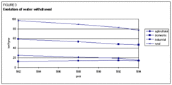 Figure 3. Evolution of water withdrawal. (Source: FAO) Figure 3. Evolution of water withdrawal. (Source: FAO) In 1982, the water withdrawal was 97.8 km3, while in 1994 it had dropped to 77.1 km3 (Figure 3). This reduction in water consumption, which concerns industrial and irrigation water withdrawal, has been related to the difficult economic situation in the Russian Federation, which worsened in 1990. Of the total water withdrawal of 77.1 km3 in 1994 for domestic, agricultural, and industrial purposes, almost 20% was used for irrigation (Figure 4).
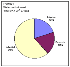 Figure 4. Water withdrawal. (Source: FAO) Figure 4. Water withdrawal. (Source: FAO) Only a small quantity of wastewater under-goes treatment. In 1990, the quantity of produced wastewater was estimated at about 33.9 km3, of which only 5.1 km3, or 15%, was partly or fully treated. Pollution in most industrial centers has reached dangerous levels and rivers have been severely polluted. The country has a long history of serious environmental accidents, especially in the fuel and chemical industries.
Irrigation and Drainage Development
Larger scale irrigation and drainage works started at the beginning of the eighteenth century. The main goal of the water works was not the development of agriculture, but to use the water to generate power for the mines and steelworks of the southern Urals, and to drain areas near the then capital, Saint Petersburg. However, the damming up of water in the neighborhood of the Urals also enabled the development of irrigation, while the drainage works turned some of the swamps into cultivable land. During the nineteenth century, irrigation developed slowly, mainly outside the territory of today's Russian Federation. In 1894, the first government land improvement institution was established, called the Department of Land Improvement, and water legislation was introduced in 1902. In 1916, about 214,000 ha of irrigated land and 890,000 ha of drained land were used for agriculture within the territory of the present Russian Federation. A sudden acceleration in drainage and irrigation work took place between 1920 and 1931, in connection with the great electrification program (GOELRO). Initially, electrification always had priority over irrigation and drainage. Only in the 1950s, during the construction of the Volga cascade reservoirs, did irrigation become as important as hydro-electricity in water development design. In 1967, the irrigated area was 1.62 million ha, which was eight times the irrigated area of 1916, while the drained area of 1.64 million ha was almost twice that of 1916. By the end of the 1980s, every year, up to 200,000 ha of newly irrigated areas and 160,000 ha of newly drained areas were given for agricultural use. However, the scale of the negative effects resulting from the drying up of swamps and from the salinization of irrigated areas was increasing. The rhythm of development of irrigation and drainage work slowed down at the beginning of the 1990s.
Irrigation Development
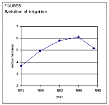 Figure 5. Evolution of irrigation. (Source: FAO) Figure 5. Evolution of irrigation. (Source: FAO) Based on climate and soil conditions, it is estimated that 15-20% of the cultivable area needs irrigation in the moderately warm dry semi-desert zone, 5-8% in the moderately warm semi-dry steppe zone, 2-5% in the moderately warm semi-dry forested steppe zone, and 1-2% in the moderately warm forest zone. Figures for irrigation potential are estimated at almost 29 million ha under permanent irrigation. Other sources give a potential of more than 74 million ha of complementary irrigation.
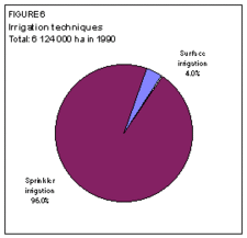 Figure 6. Irrigation techniques. (Source: FAO) Figure 6. Irrigation techniques. (Source: FAO) In 1990, irrigation covered 6.12 million ha. In 1994, however, it had fallen to 5.16 million ha, which was equal to about 4.4% of the cultivated area (Figure 5). One reason for the decrease has been the economic recession. The sprinkler systems (accounting for almost 96% of the area equipped for irrigation in 1990) are overused, and there is no maintenance and operation system. This progressively results in the complete destruction and subsequent abandonment of the schemes. Another reason might be that in the past the statistics were overestimated; the figures for more recent years seem to be more reliable. The largest irrigation development has taken place in the north Caucasian and Volga regions.
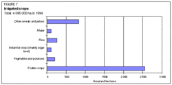 Figure 7. Irrigated crops. (Source: FAO) Figure 7. Irrigated crops. (Source: FAO) Irrigation was undertaken mainly on huge ‘’sovkhoz’’ and, to a smaller extent, on ‘’kolkhoz’’. Water fees were formally introduced in 1982, but the charge was quite insignificant and never actually collected. Until 1996, there existed no organizational forms of water administration for the newly created farms. Most of the land under irrigation is commanded by reservoirs, and open canals convey the water to the irrigation schemes. The largest canals are: Saratovski, Donski, Magistral, Great Stavropolski, Tersko-Kumski, and Kumo-Manycki. Within the schemes, underground pipes convey the water to the emitters (rain guns). Sprinkler irrigation is the most widely used technique (96% of the area), surface irrigation being used on the remainder (Figure 6). In 1990, only 21% of the irrigated land was equipped with a drainage system.
In 1994, irrigated crops covered almost 4.1 million ha, equal to 79% of the equipped area. Fodder represented the largest irrigated crop area with almost 2.6 million ha, 62% of the total. It was followed by cereals and pulses (Figure 7). Yields of irrigated crops are higher than those of rainfed crops. Irrigated maize yields are about 2.7 tons per hectare (t/ha) compared with 1.7 t/ha for rainfed maize. For barley, the respective figures are 2.25 and 1.65 t/ha.
Drainage Development
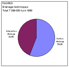 Figure 8. Drainage techniques. (Source: FAO) Figure 8. Drainage techniques. (Source: FAO) 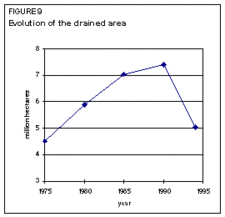 Figure 9. Evolution of the drained area. (Source: FAO) Figure 9. Evolution of the drained area. (Source: FAO) In 1990, the drained area was 7.4 million ha, of which almost 44% was equipped with subsurface drainage systems (Figure 8). However, in 1994 the drained area had dropped to about 5 million ha. This fall was due either to the breakdown of the infrastructure because of overexploitation without proper maintenance, or to the theft of pipes or the destruction of drains (Figure 9). In 1994, crops were grown on 2.45 million ha of drained land, the major crops being fodder crops followed by cereals (Figure 10). Yields of drained crops are somewhat lower than those of rainfed crops. This might be explained by the fact that drained land is already of marginal quality. Soils are very poor with a low pH and are not really suitable for cultivation. Another reason for the low yields might be the advanced state of degradation of large parts of the drained land.
In 1994, about 25.6 million ha were estimated to be excessively humid and marshy areas needing drainage. Over 15 million ha were estimated to be salinized and 24.3 million ha to have saline soils (solontchak).
Institutional Environment
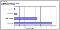 Figure 10. Crops grown on drained areas. (Source: FAO) Figure 10. Crops grown on drained areas. (Source: FAO) Under the Soviet Union, the Ministry of Water Administration (Minvodkhoz) functioned at the level of the Soviet Union, and the Ministry of Land Improvement at the Russian Federation level. After the ending of the Soviet Union, both ministries were dissolved. The 89 administrative units of the Russian Federation are now entitled to develop their own water administration policy and establish suitable organs. At federation level, two ministries are responsible for water administration:
- The Ministry of Nature Protection, responsible for water resources protection and water quality;
- The Ministry of Agriculture, whose activity during recent years has concentrated on structural transformations in the agricultural sector.
Irrigation and drainage activities are the responsibility of the Russian Water Committee (Roskomvod), reporting to the Ministry of Agriculture, and also of joint stock companies, carrying out irrigation and drainage works, subordinate to the ministry.
The State Hydrological Institute in Saint Petersburg is an independent unit, reporting directly to the government. It focuses not only on scientific research and estimation of water resources, but also prepares plans for water resources utilization and supervises their execution with regard to resources protection.
The institutes of the Russian Academy of Sciences involved in soil and water research programs are: the Institute of Water Resources (Institut Vodnych Problemov RAN) and the Institute of Geography (Institut Geografii RAN). Irrigation and drainage techniques, land cultivation within improved areas and similar problems are the concern of the scientific institutions reporting to the Academy of Agricultural Sciences.
The main information center concerning water resources and their utilization is the `Vodinform' Agency in Moscow.
Trends in Water Resources Management
After a period of rapid irrigation development, there was a slow-down and the area equipped for irrigation even decreased by 16% between 1990 and 1994. Even faster was the process of degradation of irrigation equipment. During the same period the drained area decreased by 22%. However, in this case it can be assumed that the official data from 1990 were overstated and that the actual drop was a little slower. The declining trend persisted in the period 1994-1996. During this period, there was practically no new irrigation or drainage development and part of the formerly cultivated lands was excluded from use. The reasons have been the general difficult situation in Russian agriculture and the low yields on irrigated and drained lands.
Large irrigated and drained areas are used for growing unprofitable crops like fodder crops, grain, and potatoes. On irrigated areas, crop yields are higher than on rainfed land, but the difference is not always significant. On drained areas, yields are often even lower than those of rainfed crops.
During the last few years, there has been a decrease in crop yields on irrigated and drained areas. One of the reasons for this has been the rise of the Caspian Sea level. In the Povolzhe region (Volga), this has caused groundwater levels to rise and the flooding of fields. This process has affected 719,000 ha of irrigated land and 563,000 ha of drained land in the districts of Astrakhan, Volgograd, Saratov, and Samara. The causes of the rise of the Caspian Sea level have not yet been explained.
Though water management policies can be decided by the 89 administrative units themselves, most of them have not yet prepared their future programs. The exception is Kalmykia, located between the mouth of the Volga River and the Caucasus mountains. This is one of the richest parts of the Russian Federation and large irrigation projects have been planned for the period 1998-2003, to be irrigated mostly from groundwater.
The Volga River is the river worst affected by pollution, as it receives 45% of all the sewage water of the Russian Federation. However, due to the recession, industrial activity has decreased in recent years, resulting in less sewage water.
Further Reading
The most complete information on the present state of irrigation and drainage in the Russian Federation is available in statistical yearbooks in Russian (which contain more information than the English versions) and in the publications: Melioratsia i Vodnoe Chozaystvo (Drainage and Water Management) and Vodnye Resursy (Water Resources), published by the Russian Academy of Sciences in cooperation with the Ministry of Agriculture, Publishing House: Agropromizdat.
- Kopytny, L.M. 1996. Water resources of Siberia (Vodnyye resursy Sibirii). Scholar Geography (Geografia v shkole), No 1, pp. 15-20. Ministry of Education, Moscow. (in Russian)
- Murray Fackbakh (ed.). 1995. Environmental and health atlas of Russia. Paims, Moscow. 320 p.
- Goskomstat (Russian State Committee of Statistics). 1995. Statistical yearbook of Russia (Rossiyskiy statisticheskiy ezegodnik). 1995. Moscow. 978 p.
- Goskomstat Rosii. 1995. Agriculture in Russia (Sel'skoye khozaystvo Rosii). Moscow. 504 p.
- Ministry of Natural Environment and Resources Protection. 1994. The state of the environment and environment protection on the ex-USSR territory (Sostoyanie okruzayushtchey sredy i prirorookhronnaya deyatel'nost na territorii byvshego SSSR). Moscow. 160 p. (in Russian).
- Tcherneyev, A.M. et al. 1992. Water resources and water management in Russia (Vodnyye resursy i vodnoye khozaystvo Rosii). Drainage and Water Management (Melioratsia i Vodnoye Khozaystvo), No 9-12, pp. 2-5, Agropromizdat/Ministry of Agriculture, Moscow. (in Russian).
| Disclaimer: This article is taken wholly from, or contains information that was originally published by, the Food and Agriculture Organization. Topic editors and authors for the Encyclopedia of Earth may have edited its content or added new information. The use of information from the Food and Agriculture Organization should not be construed as support for or endorsement by that organization for any new information added by EoE personnel, or for any editing of the original content.
|
|
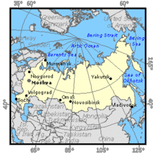 Map of the Russian Federation. (Source: FAO)
 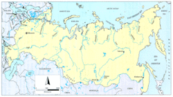 Map of the Russian Federation. (Source: FAO)
 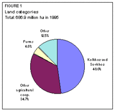 Figure 1. Land categories. (Source: FAO)
 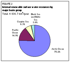 Figure 2. Internal renewable surface water resources by major basin group. (Source: FAO)


