Water profile of Nepal
Contents
Geography and Population
Nepal is located entirely in the Ganges basin and is bordered by India in the east, south and west and by China in the north. With fifteen peaks higher than 7,000 meters (m), including the world's highest peak Mount Everest at 8,848 m, Nepal is one of the highest countries in the world. The total land area of Nepal is 143,000 square kilometers (km2). Physiographically, the country can be divided into three parts: the high Himalayas in the north (23.7 percent of the country's total area); the hill and mountain slopes in the center (56.2 percent) which include the lower hills called siwalik where elevations vary between 300 and 700 m; and the plain in the south at elevations below 300 m (20.1 percent). For administrative purposes, the country is divided into 5 development regions and 75 districts.
The cultivable area has been estimated at some 4 million hectares (ha), of which 34 percent in the terai plain, 8 percent in the siwalik, 48 percent in the mountain and hill region, and 10 percent in the high Himalayas. Some 2.6 million ha are cultivated, mainly with annual crops.
The total population was estimated in 1996 at 22 million inhabitants (86 percent rural). The latest national census (1991) showed that 7.8 percent of the total population was living in the mountain region, 45.5 percent in the hill region and 47.6 percent in the terai region. Through comparison with 1981 census data, the annual average growth rate of population has been established at 2.1 percent. The highest population density reached 1,710 inhabitants/km2 in 1991 in the capital district Kathmandu and 1,454 inhabitants/km2 in Bhaktapur district near the capital. The lowest density was 2.4 inhabitants/km2 in Manang district (a Himalayan valley).
Agriculture contributed 40 percent of the Gross Domestic Product (GDP) in 1996 and employed more than 93 percent of the economically active population of the country. The main agricultural exports are pulses, jute, and rice. The prevailing high population growth and low growth rates in the agricultural and industrial sectors have resulted in a continuous deterioration in real per caput GDP.
Climate and Water Resources
Climate
Extremely varied topography within a small width ranging from 145 to 241 kilometers (km) influences the weather and climate of Nepal. The country experiences tropical, meso-thermal, micro-thermal, taiga (Biome), and tundra (Biome) types of climate. The mean annual rainfall is 1,500 millimeters (mm), with a maximum annual rainfall record of 5,581 mm in 1990 at Lumle in Kaski district (elevation of 1,740 m) in the mountain region; and a minimum record of 116 mm in 1988 at Jomosom in Mustang district located at 2,744 m in the Kaligandi River valley near the Annapurna Himalayan range. There are two rainy seasons in Nepal: one in the summer (June to September) when the southwest monsoon brings more than 75 percent of the total rainfall, and the other in winter (December to February) accounting for less than 25 percent of the total. With the summer monsoon, rain first falls in the southeast of the country and gradually moves west with diminishing intensity. Thus, more rain naturally occurs in the east of the country. On the other hand, during winter, rain occurs as a result of westerly disturbances. This rain first enters Nepal in the west and gradually moves east with diminishing intensity.
The temperature decreases from the lowland terai (northern part of the Ganges plain) to the high Himalayan region. The extreme temperatures recorded show that in Lomangtang (Mustang district) located at an elevation of 3,705 m the minimum temperature was -14.6°C in 1987, while in Dhangadhi (Kailali district) located at an elevation of 170 m the maximum temperature reached was 44°C in 1987. Precipitation falls as snow at elevations above 5,100 m in summer and 3,000 m in winter. Temperature is a constraint on crop production in the Himalayas and the mountain region where only a single crop per year can be grown. On the other hand, in the terai, three crops a year are common where the water supply is adequate. Single rice cropping is possible up to elevations of 2,300 m while double rice cropping is limited to areas below 800 m.
River Basins and Water Resources
All rivers in Nepal drain into the Ganges River. The country is divided into five river basins, which are from west to east:
- the Mahakali River basin, which is shared with India, with an average flow from the Indian tributaries into the border river estimated at 15 cubic kilometers pear year (km3/year) and some 3.4 km3/year from the Nepalese tributaries;
- the Karnali River basin, with an average outflow estimated at 43.9 km3/year;
- the Gandaki River basin, with an average outflow estimated at 50.7 km3/year;
- the Kosi River basin, with an average outflow estimated at 47.2 km3/year, but which receives a contribution of some 12 km3/year from the upper catchment area located in China (47,2902);
- the southern river basins, which produce some 65 km3/year of water flowing into India.
The seasonal distribution of flow is extremely variable. It might be as low as 1.5-2.4 percent of the total runoff in January, February, and March, and as high as 20-27 percent in July and August for snowfed rivers, while the corresponding figures for purely rainfed rivers are 0.5-3 percent from March to May and 19-30 percent in July and August.
The surface water resources produced internally are estimated at 198.2 km3/year. The groundwater resources have not been fully assessed. Ongoing studies show that a good potential for groundwater extraction exists, especially in the southern lowland plains (terai) and inner valleys of the hilly and [[mountain]ous] regions. Much of the terai physiographic region and some parts of siwalik valleys are underlain by deep or shallow aquifers, many of which are suitable for exploitation as sources of irrigation water. A rough estimate can be made by assuming a groundwater resource equivalent to ten percent of surface water, i.e. approximately 20 km3/year, which corresponds to the base flow of the rivers. The total internal water resources would therefore amount to 198.2 km3/year. Chinese statistics mention an average outflow to Nepal of 12 km3/year, which brings the total renewable water resources of Nepal to 210.2 km3/year. This makes Nepal one of the Asian countries with the highest level of water resources per inhabitant. It is assumed that all the renewable water resources of Nepal flow out of the country to India.
No agreements have been established with China for the sharing of water resources. A joint commission for the exploitation of the Kosi River was set up with India in 1954 and 1966, and another for the exploitation of the Gandak River in 1959. Recently, a new treaty on the Mahakali River has been ratified by parliament. The treaty makes provision for equal entitlement in the utilization of water from the Mahakali River without prejudice to respective existing consumptive uses.
Lakes and Dams
The total dam capacity is 85 million cubic meters (m3), although the potential exists for at least 138 km3. Hydroelectricity accounts for more than 96 percent of total electricity generation. The two main diversion barrages are the Kosi and Gandaki reservoirs.
Water Withdrawal
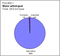
Water withdrawal for the domestic sector is from different types of sources such as springs, wells (open and tube), rivers/streams, traditional stone taps, and modern piped systems (Figure 1). Data on withdrawals exist only for public piped systems developed after 1974. However, a feasibility study conducted by a Thai study team in November 1993 on the Kodkhu Water Supply Project estimated that the industrial consumption (including commercial) for the urban valley of Kathmandu represented about 5 percent of the domestic demand in the year 1991.
None of the irrigation systems in Nepal measures the quantum of water supplied to irrigation. The available data are: (i) annual diversion requirements for monsoon and year-round irrigation based on physiographic [[region]s]; and (ii) irrigation command areas split into seasonal (monsoon) and year-round. Considering that water application depends on soil type, land type, cropping pattern, evapotranspiration, effective rainfall and conveyance losses, a special study needs to be conducted to determine a more accurate estimate of irrigation water withdrawal.
It is reported that the piped domestic water supply reached 67 and 39 percent of the population in urban and rural areas respectively in 1992. Compared with the statistical data on piped water supply for the 1994/1995 fiscal year, the average consumption per caput per day in the areas with access to piped water is about 83 liters.
Irrigation and Drainage Development
Irrigation development in Nepal has a long history. Numerous small raj kulos (canals) in the government sector first appeared in and around Kathmandu valley in the seventeenth and eighteenth centuries. The first large public sector irrigation canal system (the Chandra Canal System) with a net command area of 10,000 ha was constructed in 1922 and is still in operation.
The irrigation potential of the country has been estimated at 2,177,800 ha, including some 412,000 ha which are not cultivated, mainly in the terai area. This potential is mainly for surface irrigation, but some 352,050 ha are potentially irrigable from groundwater in the terai region, consisting of 292,600 ha from shallow tube-wells (83 percent) and 59,450 ha from deep tube-wells (17 percent)
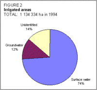
In 1994, the total irrigated area in Nepal was estimated by the Land Resources Mapping Project at 1,134,334 ha. This included 140,195 ha of groundwater irrigation, 837,913 ha of surface water irrigation and 156,226 ha of irrigation systems not fully identified (Figure 2). Except for one system (the Banganga system with 6,500 ha), all the areas under existing surface irrigation systems are dependent on transit flow availability at the sources. Therefore, the irrigated area varies from season to season and from region to region. The total year-round irrigated area has been estimated at 355,054 ha.
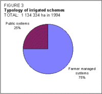
Irrigated areas in Nepal are often classified as public systems and farmer managed irrigation systems (FMISs) (Figure 3).
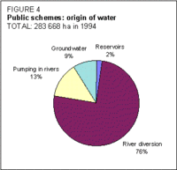
Public schemes cover an area of 283,658 ha, with 258,416 ha (91 percent) dependent on surface water and 25,242 ha (9 percent) dependent on groundwater (Figure 4).
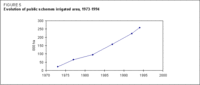
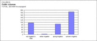
They are managed by the Department of Irrigation. These public surface irrigation schemes have expanded steadily since 1973 (Figure 5). Out of the 283,658 ha equipped for irrigation, only 187,153 ha are irrigated in summer, 86,056 ha in spring and 3,200 ha in winter (Figure 6).
FMISs in Nepal have operated successfully for centuries. Most FMIS diversion structures are constructed from brushwood and boulders, and are therefore temporary and often washed away during monsoon season. The FMIS canals are generally unlined and prone to damage. There is, typically, a large expenditure of labor every year to restore the systems or to maintain them. In spite of these physical limitations, FMISs have demonstrated managerial skills (at community level) that have kept them functioning and contributing significantly to Nepal's food supply. The total area of the FMISs was estimated at 850,676 ha in 1994. FMISs can be either entirely managed by farmers or assisted by specialized agencies.
The great majority of irrigation systems use surface irrigation (basin, furrow). Recently some areas in the hills and [[mountain]s] have begun to use sprinkler irrigation, but no figures are available.
The modernization of irrigation systems and improved water management practices could lead to a reduction in irrigation water withdrawal. On the other hand, a higher cropping intensity on the irrigated areas (only 16 percent of the irrigable areas are irrigated year-round), which would be desirable because of the increasing need for food supply, would result in increased agricultural water withdrawal.
Nepal is mainly a rural society, and there is a traditional belief that water is a god-given free commodity. Only the water supplied to urban areas for domestic use is charged on a volumetric basis. Irrigation water is levied as a service charge. This charge is levied only for the public irrigation systems. It varies from US$1.3 to 8.0/ha depending upon the type and source of supply.
The average cost for irrigation development varies from US$2,900 to 3,700/ha for the large schemes, and from US$850 to 4,300/ha for small hill schemes. The average cost for irrigation rehabilitation varies from US$1,000 to 1,800/ha. The average cost of operation and maintenance (O&M) is about US$42/ha in the smaller schemes, and US$8-14/ha in the larger schemes.
The main irrigated crop is paddy, followed by wheat in winter.
Non-formal associations have existed for a long time in almost all FMISs. WUAs received legal status after the promulgation of the 1992 Water Resources Act. The WUA has now become a prerequisite for the transfer of public schemes to users.
Institutional Development
The major government institutions currently involved in the water resources and irrigation sectors are:
- the Ministry of Water Resources (MOWR);
- the Department of Hydrology and Meteorology, in charge of water resources assessment, and monitoring;
- the Department of Irrigation (DOI). The DOI's main functions consist of the planning, design, and implementation of major and minor irrigation systems and the sustained O&M of some of the completed systems. Its mandate covers all aspects of irrigation, irrigated agriculture and policy implementation.
Other institutions that have direct linkages with the irrigation sector are:
- the National Planning Commission Secretariat (NPC), which prepares plans for all sectors including irrigation;
- the Water and Energy Commission Secretariat (WECS), which is a consultative body of the Government;
- the Department of Agriculture (DOA), whose function is to increase agricultural productivity, notably through irrigation;
- the Agriculture Development Bank of Nepal (ADB/N), which provides concessional loans and channels government subsidies for rural projects.
In addition, FMISs can also be classed as institutions in that they are voluntary associations of farmers who organize themselves to build irrigation infrastructures, and to manage them in accordance with formal or informal rules and procedures.
Trends in Water Resources Development
The 8th Five Year Plan (1992-1997) recognized that farmer participation is crucial for the improved management of the available supply of irrigation water. Accordingly, the following policy elements have been emphasized by the Government:
- The irrigation projects managed (Water governance) at government level should be gradually transferred to WUAs. Such a transfer would affect the schemes of 2,000 ha in the terai and 500 ha in the hills and mountains.
- No water service charge should be levied on schemes transferred to WUAs.
- Before transferring the schemes to WUAs, the schemes should be rehabilitated and strengthened in accordance with the demands of WUAs. For this, a cost-sharing mechanism should be introduced with a view to providing WUAs with a sense of ownership. About 5-15 percent of the rehabilitation cost should be financed directly from WUAs and farmers.
In addition, the Government has also given individual farmers the possibility of receiving subsidies. Farmers wishing to manage small irrigation systems (up to 25 ha in the terai and 10 ha in the hills and [[mountain]s]) would be required to bear the investment cost (in kind or cash) up to a maximum of 60 percent as follows:
- for shallow tube-wells - 60 percent
- for sprinkler or drip irrigation - 40 percent
- for lift irrigation - 25-60 percent
- for surface (gravity) irrigation - 40 percent
The remainder could be financed by the Government, NGOs, or social organizations.
Water management should be adjusted to enable the conjunctive use of surface water and groundwater.
Further Reading
- Water profile of Nepal, Food and Agriculture Organization.
- World Factbook: Nepal, Central Intelligence Agency.
- Canadian International Water Energy Consultants. 1990. Master plan for irrigation development in Nepal, p. 220. Kathmandu.
- Central Bureau of Statistics. 1994. Statistical pocketbook, p. 275. Kathmandu.
- Department of Hydrology and Meteorology. Climatological and surface water records of Nepal.
- East Consult (P) Ltd. Kathmandu. 1995. Updated master plan for irrigation development in Nepal. Four volumes.
- Ministry of Finance. 1994, 1995 & 1996. Economic survey reports.
| Disclaimer: This article is taken wholly from, or contains information that was originally published by, the Food and Agriculture Organization. Topic editors and authors for the Encyclopedia of Earth may have edited its content or added new information. The use of information from the Food and Agriculture Organization should not be construed as support for or endorsement by that organization for any new information added by EoE personnel, or for any editing of the original content. |