Water profile of Mozambique
Contents
- 1 Geography, Climate, and Population
- 2 Economy, Agriculture, and Food Security
- 3 Water Resources and Use
- 4 Irrigation and Drainage Development
- 5 Water Management, Policies, and Legislation Related to Water Use in Agriculture
- 6 Environment and Health
- 7 Perspectives for Agricultural Water Management
- 8 Further Reading
Geography, Climate, and Population
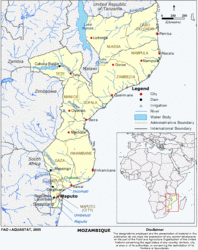 Map of Mozambique (Source: FAO)
 Mozambique is located on the east coast of southern Africa on the Indian Ocean, between latitudes 10°27?S and 26°52?S and longitudes 30°12?W and 40°51?W. The country is bordered by the United Republic of Tanzania in the north, South Africa in the south, Swaziland in the southwest and South Africa, Zimbabwe, Zambia in the west, and Malawi in the northwest. The country has a total area of 801,590 square kilometers (km2), of which 2 percent are inland waters. The country is about 1,750 kilometers (km) long and its maximum width is about 1,100 km. The land borders have a length of 4,445 km, while the [[coast]line] measures 2,515 km.
There are three basic geographic divisions:
- A [[coast]al belt] which covers about 44 percent of the country, comprising most of the areas south of the Save River and the lower Zambezi area;
- A middle plateau, ranging from 200 - 1,000 meters (m) in elevation and covering about 29 percent of the country;
- A plateau and highland region with average elevations of around 1,000 m to the north of the Zambezi River covering about 27 percent of the country.
About 62 million hectares (ha), or 78 percent of the total area, are covered by natural vegetation, consisting of high forest (0.8 percent), low forest (13.8 percent), thicket (43.4 percent), wooded grasslands (19.5 percent), and mangroves (0.5 percent). The total cultivable land is estimated at 36 million ha, which is 45 percent of the total area of the country. In 2002, the cultivated area was estimated at 4.44 million ha, of which 4.20 million ha arable land, while 0.24 million ha were under permanent crops (Table 1).
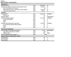 Table 1. Basic statistics and population (Source: FAO)
 The climate varies from tropical and subtropical conditions in the north and central parts of Mozambique to dry semiarid steppe and dry arid desert climate in the south. The hottest regions are located in the Zambezi basin, the [[coast]line] of Cabo Delgado, Nampula, Zambezia, and Sofala. The south is the coolest part of the country, with an average maximum and minimum temperature of 30 °C and 19 °C respectively.
The annual average precipitation for the whole country is 1,032 millimeters (mm) and the rainy season lasts from October to April. Precipitation varies widely from the coast to the inland areas and from north to south. Average rainfall ranges from 800 to 1,000 mm along the coast, with values above 1,200 mm between Beira and Quelimane. The rainfall decreases inland reaching 400 mm at the border with South Africa and Zimbabwe. The north and central part of the country has annual rainfall from 1,000 to over 2,000 mm because of the northeast monsoon and high mountains. In the southern inland part of the country average annual rainfall ranges from 500 to 600 mm. Evapotranspiration varies between 800 and above 1,600 mm. Along the coast it varies between 1,200 and 1,500 mm. Maximum values of above 1,600 mm occur in the eastern and middle Zambezi basin. Values around 800 mm occur in central Niassa and on the border with Zimbabwe.
Total population is estimated at 19.2 million (2004), with a population growth rate of 2 percent (Table 1). The population density was 24 inhabitants/km2 and 63 percent of the population is rural. Mozambique is one of the poorest countries in the world, ranking 170 out of 173 countries on the Human Development Index 2002 of UNDP. Some 70 percent of the population live below the poverty line. In 2002, 76 percent of the urban and 24 percent of the rural population were using improved drinking water sources (Table 1).
Economy, Agriculture, and Food Security
Mozambique’s Gross Domestic Product (GDP) was US$4.3 billion in 2003, and the value added by agriculture was 23.5 percent of the GDP in 2002. Agriculture provides work for 80 percent of the economically active population, and 60 percent of the people working in the sector are female. Since the end of the civil war in 1992, Mozambique has made impressive gains in restoring food production and at a national level the country is virtually self-sufficient in terms of food grain production, with the exception of wheat and rice. However, this growth has been uneven spatially and natural disasters such as flood and drought are an important cause of temporary food insecurity.
The agriculture sector comprises two categories of producers: the smallholder "family" sub-sector and the commercial sub-sector:
- The smallholder sub-sector accounts for about 95 percent of the area under production and produces almost all the food crops, such as maize, cassava, rice, and beans. It is characterized by small areas (1.8 ha each on average), low inputs, inadequate equipment ,and low yields and returns; almost all production is rainfed, as the farmers cannot afford to install irrigation systems. Within this sector a small group of emergent commercial farmers exists who use some agricultural inputs and sell their products in local markets. This group believes that one of their prime needs is the establishment or improvement of irrigation systems.
- Small and medium private companies represent the commercial sub-sector. These companies have some technological know-how, use agricultural inputs, generally have access to credit and, particularly in the south of the country, have access to irrigation. They are an important source of employment and notably contribute to technology dissemination and transfer. Their production is directed to supplying national markets, the agro-industries and for exportation. The main export crops are cotton, cashew nuts, sugar cane, tobacco, and tea.
The prevalence of HIV/AIDS among adults (15-49 years) was 13 percent by end-2001, with the central provinces of Zambezia, Tee, Manica, and Sofala being affected above average.
Water Resources and Use
Water Resources
Mozambique has 104 identified river basins that drain the central African highland plateau into the Indian Ocean. The majority of the rivers have a highly seasonal, torrential flow regime, with high waters during 3-4 months and low flows for the remainder of the year, corresponding to the distinct wet and dry seasons.
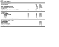 Table 2. Water: sources and use (Source: FAO)
 Groundwater potential is considerable and lies in the alluvial formations of the various rivers. Well yields in the Zambezi and Incomati basins are up to 70,000 cubic meters per day (m3/day).
In Mozambique, 97.3 km3 of surface water and 17 km3 of groundwater are produced annually. Considering an overlap between surface water and groundwater of 14 km3/yr, the total internal renewable water resources are 100.3 km3/yr (Table 2). In addition, 116.8 km3 of surface water enter the country annually, of which 66 percent from the Zambezi River, and thus total actual renewable water resources become 217.1 km3/yr.
The two main lakes are Lake Niassa (Lake Malawi) and Lake Chirua (Lake Chilwa), both of which are shared with Malawi. The total surface area of Lake Niassa is 30,800 km2, of which 21 percent belong to Mozambique. Lake Chirua has an average total area of 750 km2 of which no more than 29 km2 are within Mozambique. In addition to the two main lakes, there are more than 1,300 small lakes, 20 of which have an area of between 10 and 100 km2.
The total capacity of 27 dams with a height of 10 m or more is estimated at 64.5 km3. This refers mostly to the useful reservoir capacity. The Cahora Bassa dam on the Zambezi River is the largest hydroelectric plant in southern Africa with an installed capacity of 2,060 megawatts (MW) and a useful storage capacity of 39.2 km3. In 1971, 583 small dams (of which 90 percent were for irrigation or livestock watering) were registered, with a total volume of 60 million m3. It is believed that most of them were destroyed during the war.
Water Use
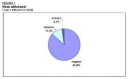 Figure 1. Water withdrawal (Source: FAO)
 Water use estimates for the year 2000 indicate a total water withdrawal of 635 million m3 (Table 2 and Figure 1). The main consumer of water is agriculture, accounting for 550 million m3 (87 percent), followed by the domestic sector using 70 million m3 (11 percent), and industry consuming 15 million m3 (2 percent).
The main source of water in Mozambique is surface water. However, groundwater is utilized on a large scale in a number of urban centers for drinking water supply. Handpump-mounted boreholes and shallow wells are used throughout the country as the main source of drinking water in rural areas.
International Water Issues
Mozambique shares nine river basins with other countries:
- The Maputo basin, shared with South Africa and Swaziland. The river flows through an area of rich biodiversity recognized by UNEP and having the status of a world conservation area.
- The Umbeluzi basin, shared with South Africa and Swaziland. The river is important for the water supply of the capital Maputo. A large irrigation scheme exists in Swaziland and there are smallholder schemes in Mozambique. The two countries have signed an agreement for water sharing, but this agreement is not favorable to Mozambique.
- The Incomati basin, shared with South Africa and Swaziland. Water is intensively used in South Africa mainly for irrigation, and Mozambique has some important irrigation schemes too. The flows in the main river have been very much reduced in the last 15 years.
- The Limpopo basin, shared with South Africa, Botswana, and Swaziland. The largest irrigation scheme of Mozambique, Chokwé, is located in this basin. Intensive water use in the upstream countries, especially Zimbabwe and South Africa, reduces the flows entering Mozambique. The river is now dry for 3 or 4 months in a normal year, and can actually fall dry for a period of up to 8 months in a year. There are also water quality problems at the border inflows.
- The Save basin, shared with Zimbabwe. During the 1980s, Zimbabwe carried out an intensive program for water resources development in this large basin. As a result, the Save is now dry almost on a permanent basis.
- The Pungue basin, shared with Zimbabwe.
- The Zambezi basin, shared with Angola, Namibia, Botswana, Zambia, Zimbabwe, Malawi, and the United Republic of Tanzania. One of the largest river basins in Africa and the most important one in Mozambique. It accounts for about 50 percent of the surface water resources of the country and about 80 percent of its hydropower potential with the Cahora Bassa dam.
- The Rovuma basin, shared with the United Republic of Tanzania.
There are many agreements between Mozambique and upstream neighboring countries regulating the use of shared watercourses. Recently a new agreement was signed with Swaziland regarding the management of the Incomati River.
Irrigation and Drainage Development
Evolution of Irrigation Development
Irrigation potential was estimated to be 3,072,000 ha by the Food and Agriculture OrganizationFAO (Food and Agriculture Organization (FAO)), while other sources give 3,300,000 ha. The major areas suitable for irrigation are in the center and north; the Zambezia province alone accounts for about 60 percent of the irrigation potential. The southern provinces have the highest need for irrigation but have only a small share of the land suitable for irrigation.
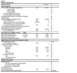 Table 3. Irrigation and drainage (Source: FAO)
 The country’s tradition of irrigation dates back to the pre-independence period. In 1968 the irrigated lands totaled 65,000 ha, out of which 72 percent were located in the Maputo and Gaza provinces. In 1973 this area had increased to 100,000 ha due to the establishment of sugar companies and Limpopo settlers, with the major area still being located in the southern provinces of Maputo and Gaza. Portuguese settlers mainly exploited these lands, while Mozambicans did not practice irrigated agriculture. After independence in 1975, the irrigated area in the country was increased by about 20,000 ha, and the total equipped area reached almost 120,000 ha in the early 1980s. Most of the areas were again in Maputo and Gaza, where significant water development works were implemented at the same time: the Pequenos Libombos Dam on the Umbeluzi River, the Corumana Dam on the Sabie River, and the Massingir Dam on the Elefantes River. In the years following independence, the government encouraged the exploitation of existing large irrigation schemes by state companies. These companies, however, became a symbol of inefficiency, mismanagement, and the subsequent deterioration of the irrigation infrastructures.
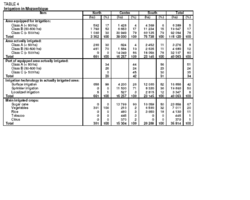 Table 4. Irrigation in Mozambique (Source: FAO)
 At the present time, irrigated areas are occupied by smallholders and agricultural enterprises. The most important large schemes are the Chokwé scheme in the Limpopo basin (25,000 ha equipped area) and a series of sugar cane plantations in the Incomati, Buzi, and Zambezi valleys (34,000 ha equipped area). Small-scale irrigation exists everywhere in the country, either abandoned or partly utilized. Most of the schemes are in a bad to very bad condition, and only a relatively small part of the irrigation schemes is actually irrigated. Reasons for this are:
- After independence the original owners abandoned the irrigated lands, and the new owners greatly lacked experience in the operation and maintenance of schemes.
- The extended civil war led to the destruction of irrigation infrastructures and forced the abandonment of others.
- Public funds for irrigation were gradually reduced.
- The lack of inputs and technical assistance in the rural areas for maintenance operations and improvements of irrigation schemes.
- The floods in 2000 and 2001 completely submerged many irrigated schemes and deposited large quantities of sediments in all natural and man-made irrigation and drainage channel networks.
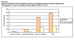 Figure 2. Types of full/partial control irrigation schemes in equipped area and actually irrigated area (Source: FAO)
 Currently, 118,120 ha are equipped for irrigation, of which 40,063 ha are actually irrigated, consisting mainly of large schemes over 500 ha (Table 3, Table 4 and Figure 2).
Basin irrigation for rice and furrow irrigation for different types of vegetables are practiced. Sprinkler irrigation is widespread with agricultural companies, especially in sugar cane plantations, but also for citrus fruits and vegetables. Some producers employ drip irrigation to produce tomatoes (3,347 ha or 8 percent of the actually irrigated area); 50 percent of the actually irrigated area is under sprinkler irrigation, while the remaining 42 percent use surface irrigation (Figure 3).
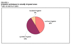 Figure 3. Irrigation techniques in actually irrigated area (Source: FAO)
 In most irrigation schemes, surface water from rivers is used. Groundwater is used to a very limited extent by the family smallholder sector.
In the north of the country there are only a few large-scale irrigation schemes that are actually irrigated, and only irrigation of class A and B schemes is operative. In the south part of the country, class C schemes account for approximately 80 percent of the equipped area. Class A schemes are mostly operated by farmers individually or organized in an association. Class B schemes are usually managed for industrial exploitation, mainly sugar cane and rice. Class C schemes are not promoted any more, as most of the recent projects are aimed at the rehabilitation and development of class A and B schemes.
Role of Irrigation in Agricultural Production, the Economy, and Society
The main irrigated crops are sugar cane, rice, citrus fruits, and vegetables (mostly tomatoes and lettuce), which are cultivated with a low intensity of 1.1-1.2 crops/year (Table 3 and Figure 4).
The cost of irrigation system development varies according to the type of irrigation technology. For surface irrigation it ranges from US$1,000 to 1,500/ha, and for sprinkler irrigation from US$1,500 to 2,000/ha. Maintenance costs are around US$500/ha per year. The rehabilitation cost, depending on the condition of the old system, can vary between US$500 and 1,500/ha.
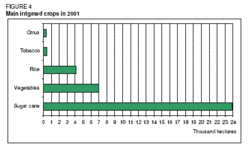 Figure 4. Main irrigated crops in 2001 (Source: FAO)
 The climate of Mozambique means that the risk of harvest loss in rainfed agriculture exceeds 50 percent in all regions south of the Save River, and can reach up to 75 percent in the interior of the Gaza province. The center and north regions of the country have more appropriate conditions for rainfed agriculture, where the probability of good harvests during the wet season is 70-95 percent. The north of the Manica province and the south of the Tete province regions are excluded from this Center-North region, as they have a risk of harvest loss in rainfed crops of usually more than 50 percent.
Irrigation efficiency is reduced to 25-50 percent, mainly in the surface irrigation areas of smallholder farmers. In agricultural companies, which use mainly sprinkler irrigation, efficiency rates are up to 70 percent.
At the smallholder level, high value crops are traditionally grown by men. Although women play an active role in all activities of irrigated production, they are in general not involved in planning and decision-making regarding the management of the scheme.
Water Management, Policies, and Legislation Related to Water Use in Agriculture
Institutions
The National Directorate for Agricultural Hydraulics (DNHA) within the Ministry of Agriculture and Rural Development (MADER) is the coordinating authority for activities relating to irrigation and drainage. It performs studies, executes agricultural hydraulics projects and supports smallholder irrigation development. Inside the DNHA, the Programa nacional de irrigacao de pequena escala (PRONIPE) was specifically created for small-scale irrigation.
The Fund for Agricultural Hydraulics Development (FDHA) is in charge of promoting, fostering, and funding the hydro-agricultural works or other activities related to irrigated agricultural development.
The National Water Directorate (DNA) within the Ministry of Public Works and Housing (MOPH) is in charge of policy making and implementation, overall planning, and management (Water governance) of the country’s water resources and the provision of water supply and sanitation services. Its objectives are to ensure the proper utilization of ground and surface water resources. In the DNA, a liaison office of international rivers was established. The Regional Water Administrations (ARAs) are basin authorities responsible for water development and management. They have administrative, organizational, and financial autonomy but report to the DNA. The ARAs are also in charge of collecting hydrological information.
The National Water Council (CNA) was created in 1991 as a consultative body to the Council of Ministers. In general, however, the CNA has not been very effective and coordination between agencies involved in water resources management has been a constant source of concern.
Water Management
|
Table 5. Characteristics of ears of responsibility of ARAs Mean annual runoff ARA At border (km3) Generated in Mozambique (km3) Total (km3) South 17.0 3.8 20.8 Center 1.2 18.4 19.6 Zambezi 88.0 18.0 106.0 Center-North 0.0 35.2 35.2 North 10.0 24.9 34.9 Total 116.2 100.3 216.5 At the national level, water management (Water profile of Mozambique) is the responsibility of the National Water Directorate (DNA), while at the regional level the five Regional Water Administrations (ARAs) are responsible. They control the irrigation systems and collect water fees. The only ARA fully operational by 2000 was ARA-Sul (South), while a second one, ARA-Centro, is under formation. ARA-Sul is in charge of the southern part of the country up to the Save River, where most problems of water management exist. In areas not yet covered by an ARA, the Provincial Directorates of Public Works and Housing are the authority responsible for water resources management in the provinces. The territorial responsibility of the five ARAs is as follows (Table 5):
Policies and LegislationThe 1991 Water Law is based on a river basin approach towards water management. According to this law, water and hydraulic structures of public interest are State property. By law, the Ministry of Public Works and Housing is responsible for water management. Furthermore, the social, economic, and environmental impact of hydraulic works has to be assessed before their implementation. The National Water Policy was issued in 1995, listing nine principal policies with the main aim being to guarantee the attainment of a sustainable water supply and sanitation. Declarations pertaining to agricultural water management in the policy are:
The National Irrigation Policy and its Implementation Strategy were adopted in 2002, recognizing the great strategic importance vested with irrigation. The guiding principles are:
Environment and HealthThe pollution of water from agriculture is not significant, because most production is by smallholders, whose level of fertilizer use and other artificial input is low because of lack of funding. Saline soils do occur in some areas in the country as a result of poor water management or the use of saline water for irrigation (for example, parts of the Chokwé irrigation scheme). However, there are also areas where saline soils occur naturally in Mozambique. This situation is common in the dry zone in the southern part of the country, in the Gaza province in the area of Pafuri, where rainfall is below 400 mm. Despite the lack of specific studies carried out in the irrigation schemes on prevailing diseases, it has been asserted that the prevalence of water communicable diseases tends to be worsened by irrigation. The diseases commonly associated with irrigation are malaria, diarrhoea, cholera, and to a lesser extent bilharzia. Perspectives for Agricultural Water ManagementThe Implementation Strategy of the National Irrigation Policy proposes the following:
The main trends in agricultural water management are to promote small-scale irrigation throughout the country, to increase water use efficiency and to integrate irrigation into the social and economic context. However, the insufficient institutional capacity both at the central and local levels is the major constraint hampering the development of the small-scale irrigation sub-sector. The institutions dealing specifically with irrigated agriculture are severely constrained by insufficient qualified human resources and an inadequate budget. A point of concern for the development of irrigation as a whole is the lack of flexibility of the legal and political framework concerning the access to and use of land and water. In terms of irrigation technology, the government is advancing the use of treadle pumps in a number of projects in the country. Irrigation using treadle pumps is beneficial for farmers because the level of required maintenance is low and there is no operational cost. A major challenge is posed by the deteriorated status of the hydro-agricultural infrastructure, requiring investment and technical assistance for its rehabilitation as well as maintenance operations. Improvements have been hampered by the lack of means, input and technical assistance. Nevertheless, the existing physical infrastructure represents a valuable asset for the economy of Mozambique. Further Reading
| ||||