Swaziland
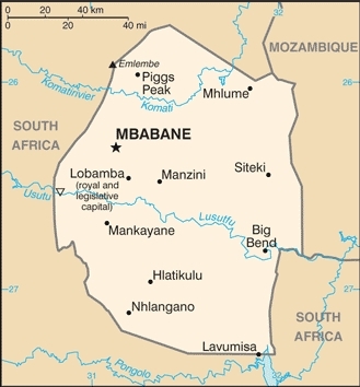
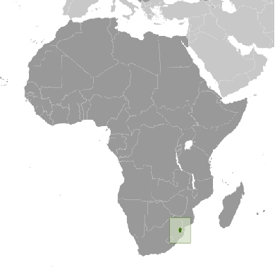
Countries and Regions of the World Collection  Swaziland is a landlocked nation of one-and-a-third million people in southern-Africa. 80% of its border is with South Africa, and the remaining portion is with Mozambique to the east.
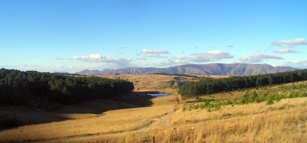
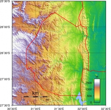
It is mostly mountains and hills; some moderately sloping plains.
Swaziland's major environmental issues include:
- limited supplies of potable water;
- wildlife populations being depleted because of excessive hunting;
- overgrazing;
- soil degradation; and,
- soil erosion.
It is susceptible to drought.
Autonomy for the Swazis of southern Africa was guaranteed by the British in the late 19th century; independence was granted in 1968.
Student and labor unrest during the 1990s pressured King MswatiI III, the world's last absolute monarch, to grudgingly allow political reform and greater democracy, although he has backslid on these promises in recent years.
A constitution came into effect in 2006, but political parties remain banned. The African United Democratic Party tried unsuccessfully to register as an official political party in mid 2006. Talks over the constitution broke down between the government and progressive groups in 2007.
Swaziland recently surpassed Botswana as the country with the world's highest known HIV/AIDS prevalence rate.
Contents
Geography
Location: Southern Africa, between Mozambique and South Africa
Geographic Coordinates: 26 30 S, 31 30 E
Area: 17,363 km2 (17,203 km2 land and 160 km2 water)
Land Boundaries: 535 km. Border countries: Mozambique 105 km, South Africa 430 km
Coastline: 0 km (landlocked)
Maritime Claims: none (landlocked)
Natural Hazards: drought
Terrain: Mostly mountains and hills; some moderately sloping plains. Its lowest point is the Great Usutu River (21 metres) and its highest point is Emlembe (1,862 metres)
Climate: Varies from tropical to near temperate
|
Topography of Swaziland. Source: Wikimedia Commons |
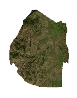
Satellite view of Swaziland. Source: The Map Library |
Ecology and Biodiversity
|
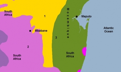
1. Zambezian and Mopane woodlands 2. Drakensberg montane grasslands, woodlands and forests 3. Maputaland coastal forest mosaic People and SocietyPopulation: 1,386,914 (July 2012 est.) The majority of the population is ethnic Swazi, mixed with a small number of Zulus and non-Africans. Traditionally Swazis have been subsistence farmers and herders, but some now work in the growing urban formal economy and in government. Some Swazis work in the mines in South Africa. Christianity in Swaziland is sometimes mixed with traditional beliefs and practices. Most Swazis ascribe a special spiritual role to the monarch. |
The country's official languages are SiSwati (a language related to Zulu) and English. Government and commercial business is conducted mainly in English.
Ethnic groups: African 97%, European 3%
Age Structure:
0-14 years: 37.8% (male 261,762/female 255,828)
15-64 years: 58.6% (male 399,746/female 403,681)
65 years and over: 3.6% (male 20,472/female 28,935) (2011 est.)
Population Growth Rate: 1.195% (2012 est.)
Birth Rate: 26.16 births/1,000 population (2012 est.)
Death Rate: 14.21 deaths/1,000 population (July 2012 est.)
Net Migration Rate: 0 migrant(s)/1,000 population (2012 est.)
Life Expectancy at Birth: 49.42 years
male: 49.77 years
female: 49.06 years (2012 est.)
Total Fertility Rate: 3.03 children born/woman (2012 est.)
Languages: English (official, government business conducted in English), siSwati (official)
Literacy (2003 est.): 81.6% (male: 82.6% - female: 80.8%)
Urbanization: 21% of total population (2010) growing ata 1.5% annual rate of change (2010-15 est.)
History
According to tradition, the people of the present Swazi nation migrated south before the 16th century from what is now Mozambique. Following a series of conflicts with people living in the area of modern Maputo, the Swazis settled in northern Zululand in about 1750. Unable to match the growing Zulu strength, the Swazis moved gradually northward in the 1800s and established themselves in the area of modern or present Swaziland.
They consolidated their hold under several able leaders. The most important was Mswati II, from whom the Swazis derive their name. Under his leadership in the 1840s, the Swazis expanded their territory to the northwest and stabilized the southern frontier with the Zulus.
Contact with the British came early in Mswati's reign, when he asked British authorities in South Africa for assistance against Zulu raids into Swaziland. It also was during Mswati's reign that the first whites settled in the country. Following Mswati's death, the Swazis reached agreements with British and South African authorities over a range of issues, including independence, claims on resources by Europeans, administrative authority, and security. South Africans administered the Swazi interests from 1894 to 1902. In 1902 the British assumed control.
In 1921, after more than 20 years of rule by Queen Regent Lobatsibeni, Sobhuza II became Ngwenyama (lion) or head of the Swazi nation. The same year, Swaziland established its first legislative body--an advisory council of elected European representatives mandated to advise the British high commissioner on non-Swazi affairs. In 1944, the high commissioner conceded that the council had no official status and recognized the paramount chief, or king, as the native authority for the territory to issue legally enforceable orders to the Swazis.
In the early years of colonial rule, the British had expected that Swaziland would eventually be incorporated into South Africa. After World War II, however, South Africa's intensification of racial discrimination induced the United Kingdom to prepare Swaziland for independence. Political activity intensified in the early 1960s. Several political parties were formed and jostled for independence and economic development. The largely urban parties had few ties to the rural areas, where the majority of Swazis lived. The traditional Swazi leaders, including King Sobhuza II and his Inner Council, formed the Imbokodvo National Movement (INM), a political group that capitalized on its close identification with the Swazi way of life. Responding to pressure for political change, the colonial government scheduled an election in mid-1964 for the first legislative council in which the Swazis would participate. In the election, the INM and four other parties, most having more radical platforms, competed in the election. The INM won all 24 elective seats.
Having solidified its political base, INM incorporated many demands of the more radical parties, especially that of immediate independence. In 1966, the U.K. Government agreed to discuss a new constitution. A constitutional committee agreed on a constitutional monarchy for Swaziland, with self-government to follow parliamentary elections in 1967. Swaziland became independent on September 6, 1968. Swaziland's post-independence elections were held in May 1972. The INM received close to 75% of the vote. The Ngwane National Liberatory Congress (NNLC) received slightly more than 20% of the vote, which gained the party three seats in parliament.
In response to the NNLC's showing, King Sobhuza repealed the 1968 constitution on April 12, 1973 and dissolved parliament. He assumed all powers of government and prohibited all political activities and trade unions from operating. He justified his actions as having removed alien and divisive political practices incompatible with the Swazi way of life. In January 1979, a new parliament was convened, chosen partly through indirect elections and partly through direct appointment by the King.
King Sobhuza II died in August 1982, and Queen Regent Dzeliwe assumed the duties of the head of state. In 1984, an internal dispute led to the replacement of the Prime Minister and eventual replacement of Dzeliwe by a new Queen Regent Ntombi. Ntombi's only child, Prince Makhosetive, was named heir to the Swazi throne. Real power at this time was concentrated in the Liqoqo, a supreme traditional advisory body that claimed to give binding advice to the Queen Regent. In October 1985, Queen Regent Ntombi demonstrated her power by dismissing the leading figures of the Liqoqo. Prince Makhosetive returned from school in England to ascend to the throne and help end the continuing internal disputes. He was enthroned as Mswati III on April 25, 1986. Shortly afterwards he abolished the Liqoqo. In November 1987, a new parliament was elected and a new cabinet appointed.
In 1988 and 1989, an underground political party, the People's United Democratic Movement (PUDEMO) criticized the King and his government, calling for democratic reforms. In response to this political threat and to growing popular calls for greater accountability within government, the King and the Prime Minister initiated an ongoing national debate on the constitutional and political future of Swaziland. This debate produced a handful of political reforms, approved by the King, including direct and indirect voting in the 1993 national elections.
Government
Government Type: Monarchy
On July 26, 2005 King Mswati III ratified Swaziland's first constitution in over 30 years. It went into effect February 8, 2006; a 1973 proclamation that had banned political parties lapsed at that time. While the current constitution does not prohibit the existence of political parties, parties are not allowed to contest elections.
According to Swazi law and custom, the monarch holds supreme executive, legislative, and judicial powers. In practice, however, the monarch's power is delegated through a dualistic system--modern, statutory bodies like the cabinet, and the traditional governing structures of the tinkhundla system. The king must approve legislation passed by parliament before it becomes law. The prime minister, who is head of government, and the cabinet, which is recommended by the prime minister and approved by the king, exercise executive authority. At present, parliament consists of a 65-seat House of Assembly (55 members are elected through popular vote; 10 are appointed by the king) and 30-seat Senate (10 members are appointed by the House of Assembly, and 20 are appointed by the king). House of Assembly elections were last held on September 19, 2008.
Swaziland is a member of the Southern African Customs Union (SACU), with which the U.S. began negotiating a free trade agreement in May 2003. The other members of SACU are Botswana, Namibia, Lesotho, and South Africa.
Capital: Mbabane - 74,000 (2009)  Source: Wikimedia Commons
Administrative divisions: For local administration Swaziland is divided into four regions, each with an administrator appointed by the king. Parallel to the government structure is the traditional system consisting of the king and his advisers, traditional courts, 55 tinkhundla (sub-regional districts in which traditional chiefs are grouped), and approximately 360 chiefdoms.
4 districts:
- Hhohho
- Lubombo
- Manzini
- Shiselweni
Independence Date: 6 September 1968 (from UK)
Legal System: based on South African Roman-Dutch law in statutory courts and Swazi traditional law and custom in traditional courts; accepts compulsory ICJ jurisdiction with reservations
Suffrage: 18 years of age
International Environmental Agreements
Swaziland is party to international agreements on: Biodiversity, Climate Change, Climate Change-Kyoto Protocol, Desertification, Endangered Species, Hazardous Wastes, and Ozone Layer Protection. It has signed, but not ratified the international agreement known as the Law of the Sea.
Water
Total Renewable Water Resources: 4.5 cu km (1987)
Freshwater Withdrawal: Total: 1.04 cu km/yr (2% domestic, 1% industrial, 97% agricultural).
Per capita Freshwater Withdrawal: 1,010 cu m/yr (2000)
Access to improved sources of drinking water: 69% of population
Access to improved sanitation facilities: 55% of population
Agriculture
Agricultural Products: sugarcane, cotton, corn, tobacco, rice, citrus, pineapples, sorghum, peanuts; cattle, goats, sheep
Irrigated Land: 500 sq km (2003)
Resources
Natural Resources: asbestos, coal, clay, cassiterite, hydropower, forests, small gold and diamond deposits, quarry stone, and talc.
Land Use:
arable land: 10.25%
permanent crops: 0.81%
other: 88.94% (2005)
Energy
| Energy in Swaziland | |||||
| Production | Consumption | Exports | Imports | Reserves | |
| Electricity | 470 million kWh (2008 est.) |
1.207 billion kWh (2008 est. |
0 kWh (2009) |
756 million kWh* (2009 est.) |
|
| Oil | 0 bbl/day (2010 est.) |
4,000 bbl/day (2010 est.) |
0 bbl/day (2009 est.) |
4,464 bbl/day (2009 est.) |
0 bbl (1 January 2010 est.) |
| Natural Gas | 0 cu m (2009 est.) |
0 cu m (2009 est.) |
0 cu m (2009 est.) |
0 cu m (2009) |
0 cu m (1 January 2011 est.) |
| Source: CIA Factbook | |||||
note - electricity supplied by South Africa
Health
Prevalence Rate of HIV/AIDS in Adults: 38.8% (2003 est.)
Major Infectious Diseases: Degree of risk: intermediate
food or waterborne diseases: bacterial diarrhea, hepatitis A, and typhoid fever
vectorborne disease: malaria
water contact disease: schistosomiasis (2008)
Conflict
International Disputes: in 2006, Swazi king advocates resort to International Court of Justice to claim parts of Mpumalanga and KwaZulu-Natal from South Africa
Economy
Swaziland ranks as a lower middle income country, but it is estimated that 69% of the population lives in poverty. Most of the high-level economic activity is in the hands of non-Africans, but ethnic Swazis are becoming more active. Small entrepreneurs are moving into middle management positions. Although more than 70% of Swazis live in rural areas, nearly every homestead has a wage earner. The past several years have seen wavering economic growth as the small economy is strongly affected by climactic conditions and external factors. In 2010, the kingdom plunged into a fiscal crisis after alterations in the Southern African Customs Union revenue-sharing formula, the receipts from which accounted for more than half of the country’s fiscal revenue. Coupled with mismanagement of public funds and overspending, the decline in SACU receipts led to a near-collapse of public finances and caused the government to draw down its foreign-exchange reserves and to seek external financing.
Nearly 60% of Swazi territory is held by the Crown in trust of the Swazi nation. The balance is privately owned, much of it by foreigners. The question of land use and ownership remains a very sensitive one. For Swazis living on rural homesteads, the principal occupation is either subsistence farming or livestock herding. Culturally, cattle are important symbols of wealth and status, but they are being used increasingly for milk, meat, and profit. Overgrazing, soil depletion, drought, and floods are persistent problems.
Swaziland enjoys well-developed road links with South Africa. It also has railroads running east to west and north to south. The older east-west link, called the Goba line, makes it possible to export bulk goods from Swaziland through the Port of Maputo in Mozambique. Most of Swaziland's imports were shipped through this port. Conflict in Mozambique in the 1980s diverted many Swazi exports to ports in South Africa. Swaziland mainly uses the port today for exports of sugar, citrus, and forest products, with future usage of the port expected to increase. A north-south rail link, completed in 1986, provides a connection between the Eastern Transvaal rail network and the South African ports of Richard's Bay and Durban.
The sugar industry, based solely on irrigated cane, is Swaziland's leading export earner and private-sector employer. Soft drink concentrate (a U.S. investment) is another large export earner, followed by wood pulp and lumber from cultivated pine forests. Pineapple and citrus fruit are other important agricultural exports.
Swaziland mines coal and diamonds for export. There also is a quarry industry for domestic consumption. In 2010, mining contributed about 1.8% of Swaziland's GDP, and predictions for the industry are mixed as coal mining is expected to increase but quarried stone production is expected to decrease.
A number of industrial firms have located at the industrial estate at Matsapha near Manzini. In addition to processed agricultural and forestry products, the industrial sector at Matsapha also produces garments, textiles, and a variety of light manufactured products. The Swaziland Industrial Development Company (SIDC) and the Swaziland Investment Promotion Authority (SIPA) have assisted in bringing many of these industries to the country. Government programs encourage Swazi entrepreneurs to run small and medium-sized firms. Tourism also is important, attracting more than 450,000 visitors annually, mostly from Europe and South Africa.
From the mid-1980s, foreign investment in the manufacturing sector boosted economic growth rates significantly. Beginning in mid-1985, the depreciated value of the currency increased the competitiveness of Swazi exports and moderated the growth of imports, generating trade surpluses. During the 1990s, the country often ran small trade deficits. South Africa and the European Union are major customers for Swazi exports.
Swaziland became eligible for the African Growth and Opportunity Act (AGOA) in 2000 and qualified for the apparel provision in 2001. AGOA created over 30,000 jobs, mostly for women, in Swaziland's apparel industry. However, the industry suffered in 2005-2006, due to both increased global competition as a result of the end of the Agreement on Textiles and Clothing (ATC) on January 1, 2005, and the strong Rand (Swaziland's currency is linked to the South African Rand at par), which reduced exports. There are an estimated 16,000 people employed in the apparel industry.
Swaziland, Lesotho, Botswana, Namibia, and the Republic of South Africa form the Southern African Customs Union, where import duties apply uniformly to member countries. Swaziland, Lesotho, Namibia, and South Africa also are members of the Common Monetary Area (CMA) in which repatriation and unrestricted funds are permitted. Swaziland issues its own currency, the lilangeni (plural: emalangeni).
GDP (Purchasing Power Parity): $6.12 billion (2011 est.)
GDP (Official Exchange Rate): $3.9 billion (2011 est.)
GDP- per capita (PPP): $5,200 (2011 est.)
GDP- composition by sector:
agriculture: 7.8%
industry: 50.8%
services: 41.4% (2011 est.
Population Below Poverty Line: 69% (2006)
Industries: coal, wood pulp, sugar, soft drink concentrates, textiles and apparel
Exports: soft drink concentrates, sugar, wood pulp, cotton yarn, refrigerators, citrus and canned fruit
Export Partners: South Africa 59.7%, EU 8.8%, US 8.8%, Mozambique 6.2% (2006)
Imports: motor vehicles, machinery, transport equipment, foodstuffs, petroleum products, chemicals
Import Partners: South Africa 95.6%, EU 0.9%, Japan 0.9% (2006)
Economic Aid Recipient: $46.03 million (2005)
Currency: lilangeni (SZL)
