Maputaland coastal forest mosaic
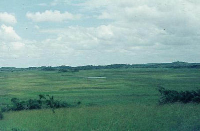
Maputo Special Reserve, Mozambique. (Photograph by Judy Oglethorpe)
Introduction Flanking the Indian Ocean, the Maputaland coastal forest mosaic includes a wide variety of habitat (Maputaland coastal forest mosaic) types, such as dry forest, swamp forest, grassland, wetland, and estuarine systems. As a result, floral and faunal diversity and endemism are high. Nearly 10 percent of vascular plant species found in the ecoregion are endemic, including three endemic plant genera. Charismatic species such as the African elephant (Loxodonta africana) are also found here, offering a high potential for ecotourism. Almost 14 percent of this ecoregion is contained in protected areas. However, invasive exotic plants and expanding populations are starting to place considerable pressure on the natural environment in South Africa. Although Mozambique is still relatively depopulated south of Maputo, there are threats from large-scale afforestation and other forms of development, even in formally designated reserves.
Location and General Description
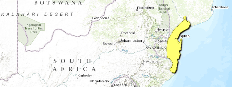
This ecoregion is found on the east coast of southern Africa and extends approximately from the Mozambican coastal town of Xai Xai in the north (25°S) to Cape Saint Lucia (28°S) in South Africa. The area consists largely of a flat or gently undulating, low-lying coastal plain with a maximum elevation of about 150 meters (m). Along most of the western margin of the ecoregion the narrow Lebombo Mountain Range rises to about 600 m in height and separates the coastal plain from the interior. Part of the ecoregion is within the Limpopo River lower reach floodplain.
 WWF
WWF
The formation of the modern landscape started after the resistant volcanic rhyolite lavas that form the Lebombo Range and underlie the coastal plain were steeply tilted eastward during the break up of Gondwanaland 140 million years ago. At the newly formed coastline, on the seaward sloping rhyolite base, Cretaceous marine sedimentary rock and conglomerates were laid down to form the present day level coastal plain. From the end of the Cretaceous, through the Tertiary and Quaternary, the coastal plain was repeatedly exposed and submerged as the southern African continental margin flexed and worldwide sea levels rose and fell. Recurring marine transgressions and regressions resulted in cycles of sedimentation and erosion, with marine deposits being laid down, then eroded and redistributed by wind and water. Thus most of the Maputaland coastal plain is covered in recent, infertile, wind-distributed sands. The result has been the formation of a series of north-south aligned dune ridges parallel to the present day coastline. The oldest of these in South Africa is immediately adjacent to the Lebombo Mountains and appears to be of Plio-Pleistocene age. Steep-sided dunes along the coast are young, and may still be forming in places. Sometimes almost 200 m in height, these dunes are amongst the tallest vegetated dunes in the world. Incised coastal river valleys filled as sea levels rose during the late Holocene, resulting in the deposition of fertile alluvial material along drainage lines and the formation of pans, swamps, and vleis where drainage lines became submerged. In South Africa, the soils of western Maputaland are fertile, especially along the west bank of the Pongolo River, because they are derived from alluvium, river terraces, and Cretaceous sediments.
The climate is moist subtropical along the coast where rainfall is over 1,000 millimeters (mm) per year, becoming dry subtropical a short distance inland with less than 600 mm per year. Rainfall increases to over 800 mm per year along the crest of the Lebombo Mountains. Summers are hot and humid with the highest monthly precipitation between September and April. Winters are cool and dry. Mean annual temperature varies from 21°C along the Lebombo Mountains to 23°C in the center of the coastal plain, moderating slightly along the coast to 22°C. The area tends to be humid throughout the year, even in the drier center of the coastal plain, although evaporation rates are high.
The Maputaland coastal forest mosaic contains extensive areas of wetland. Lake Saint Lucia covers approximately 350 km2 and is the largest estuarine system in Africa. Lake Sibayi (60 km2) is the largest freshwater lake in southern Africa, separated from the ocean by a narrow dune cordon. The Kosi Lake System (37 km2) and several similar sized water bodies such as Lake Piti in the Maputo Elephant Reserve contribute to the large amount of wetland habitat. The largest perennial river in the ecoregion, the Pongola, was dammed in the 1960s where it passes through the Ubombo Mountains and changes in the natural flood regime have affected the functioning of the river, floodplain, and associated pans.
The vegetation of the Maputaland Forest Mosaic is complex and exceptionally diverse. Moll identified and described at least 15 major vegetation types in the [[South Africa]n] part of the ecoregion. The vegetation of southern Mozambique has also been described in great detail. The vegetation types include forest, savanna woodland, grassland, and wetland habitats. Each contains its own species composition and several of the vegetation types possess signification levels of species endemism. The most notable of these different vegetation types is outlined below.
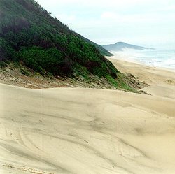 Sodwana Bay National Park, South Africa. (Photograph by John Morrison)
 Forest grows on top of the Lebombo Range, especially in deeper valleys and moister southeastern slopes. The canopy ranges from 10 m to 35 m high. While species composition is varied, canopy species such as Chrysophyllum viridifolium, Homalium dentatum, Combretum kraussii, and various Ficus, Celtis, and Strychnos spp. are most common. Understory trees and tall shrubs beneath the fairly open canopy include Buxus natalensis, Englerophytum natalense, and Rothmannia globosa. The vegetation on the rocky slopes of the Lebombos is highly variable depending on topography, soil depth, and aspect. Although difficult to describe, it tends to be an open or closed tree community, with the amount of grass cover dependant on soil depth. Common big trees reaching 10–12 meters (m) include Acacia nigrescens, Acacia burkei, Combretum apiculatum, and Pterocarpus rotundifolia. Where soils are shallow, aloes, especially Aloe marlothii, Ficus spp., and Euphorbia spp. are more common. Very steep and stony slopes tend to support a dry woody community including Olea africana and Combretum spp.
The dry ‘Sand’ forest type is particularly interesting and unique. Occurring primarily on inland palaeo-dune sands, Sand Forest is species rich, with a high number of woody endemics. Cleistanthus schlechteri and Newtonia hildebrandtii consistently dominate the canopy, although C. schlechteri, Hymenocardia ulmoides, Psydrax fragrantissima, and the understorey trees Croton pseudopulchellus and Drypetes arguta are characteristic and largely confined to these forests within the region. Endemics to this forest type, which are common within it, include Vitex ferruginea subsp. amboniensis, Hyperacanthus microphyllus, and Combretum mkuzense. A taller eastern forest type on white to yellow sands and shorter western type on red sands are clearly recognisable in South Africa, with associated turnover in subdominant species. The extensive tracts of Sand Forest south of Maputo in Mozambique tend to have Afzelia quanzensis as a co-dominant. Sand Forest actually tends to occur as a matrix, with patches of forest surrounded by open savanna with woody species such as Terminalia sericea, Strychnos madagascariensis, S. spinosa, Acacia burkei, and Combretum molle. Common grass genera in the savanna are Aristida, Digitaria, Themeda, Urochloa, Pogonathria, and Perotis.
East of the Sand Forests and on the northern border of the Mosi drainage system is an open to closed woodland type similar to the savannas of the Sand Forest matrix. In addition to the trees listed for Sand Forest savannas, Albizia adianthifolia, Dialium schlechteri, Afzelia quanzensis, and Hyphaene natalensis are common. Acacia robusta and Spirostachys africana tend to be found in low-lying areas. The composition of the grass layer is also similar to that of the Sand Forest matrix.
In some parts of the ecoregion there are extensive areas of Palm Veld. These consist of continuous grass cover of Themeda, Eragrostis, Aristida, Perotis, and other species with scattered Hyphaene natalensis palms. Another palm, Phoenix reclinata is also common, as are the short trees Dichrostachys cinerea and Strychnos madagascariensis. Grass and sedge species tend to dominate in waterlogged depressions, while raised areas and old termitaria support more trees. Palm Veld grades into open grassland towards the coast, with tussocked species such as Themeda, Tristachya, Trachypogon, Aristida, and others being common. In depressions rhizomatous or stoloniferous genera such as Hemarthria, Ischaemum, and Paspalum are more common. Dwarf woody plants, especially Parinaria curatellifolia become common closer to the coast. Where the Coast Grassveld grades into Dune forest, trees such Syzigium cordatum and Trichilia emetica become more common.
Dense forests of varying height occur on and along the coastal dunes. Mimusops caffra, Euclea natalensis, and Diospyros rotundifolia form short forests or thickets on the seaward side of the dunes. With some protection from the salt wind more diverse forests develop with canopies as tall as 30 meters. Common species include Diospyros inhacaensis, Apodytes dimidiata, Celtis africana, Drypetes gerrardii, Ziziphus mucronata, Strychnos spp. and Ficus spp.
Biodiversity Features
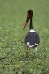 Saddlebilled stork (Ephippiorhynchus senegalensis), South Africa. (Photograph by Hans Martens)
 The Maputaland Coastal Forest Mosaic corresponds to one of three clear foci of high floristic endemism in White’s Tongaland-Pondoland Regional Mosaic. The Regional Mosaic itself is a floristically diverse and complex part of the Indian Ocean Coastal belt). Previous interest in Maputaland tended to focus on its status as a zone of biotic transition, with the southern end of the distribution of many tropical plant and animal species occurring here.
While the rapid species changes along this part of the Indian Ocean Coastal Belt contribute to high levels of diversity in this small area, this ecoregion is also exceptional for its high levels of endemism over a wide range of taxa. The number of vascular plant species is at least 2,500 and may be as high as 3,000. Of these, at least 225 species or infraspecific taxa are endemic or near-endemic. As the region’s flora becomes better studied this number is likely to rise. Among the plants, Scott- Shaw lists 26 threatened plants (IUCN status ‘vulnerable’ and higher) in the Maputaland region (South African portion), of which only 18 species are conserved in protected areas. Many of these are endemic or near-endemic, and also often rare or with restricted ranges.
Faunal diversity and endemism are also high. More than 470 bird species are found here and 4 species and 43 subspecies endemic or near endemic. The endemic Neergaard’s sunbird (Nectarinia neergaardi) is particularly interesting, as it is restricted almost entirely to the dry semi-deciduous sand forest of Maputaland. Rudd’s apalis (Apalis ruddi) is also near endemic, together with the pink-throated twinspot (Hypargos margaritatus), and the lemon-breasted seedeater (Serinus citrinipectus).
Species richness in the mammals is also high, with more than 100 species recorded, although there are no strict or near-endemic species of mammals in this ecoregion. There may be several endemic subspecies. Amphibians and reptiles are also diverse and support some endemic species. Of the approximately 112 species or subspecies of reptile found here, 23 are either endemic or near endemic while four are strictly endemic. Among the amphibians, 45 species or subspecies of frog are found in this ecoregion, with one near endemic species. Data also exist on the freshwater fishes and this is an area of some endemism for them, with a total of 67 freshwater fish species, of which 8 species are endemic or near endemic.
Elephants (Loxodonta africana, EN) are of particular importance in this ecoregion because they would have once moved freely over large distances. Today they occur in several reserves in the Maputaland Coastal Forest Mosaic. Tembe Elephant Park on the [[South Africa]n] side of the Mozambique border was actually established primarily to protect and confine the last free-ranging herds in South Africa in the early 1990’s. A herd of approximately 100 adults in the Maputo Elephant Reserve ranged outside of the reserve boundaries in 1996. Elephants have recently been re-introduced to Mkuzi Game Reserve and the privately owned Phinda Resource Reserve in South Africa.
Large predators are still an important part of the fauna in some protected areas. Leopard (Panthera pardus, EN) are relatively common. Lion (Panthera leo, VU) have been re-introduced only to the privately owned Phinda Resource Reserve. Cheetah (Acinonyx jubatus, VU) were also reintroduced into KwaZulu-Natal and are now present in many of the reserves in the ecoregion. The large areas of wetland in the Maputaland Coastal Forest Mosaic are home to considerable numbers of Nile crocodile (Crocodylus niloticus), which still frequently turn up in [[river]s] outside of conserved areas.
Most of the flora and fauna are of Afrotropical origin, and endemic taxa appear to have evolved only recently. Evidence for this includes the large number of infraspecific endemics and the young age of most of the sandy coastal plain, perhaps less than one million years.
Current Status
Given the unique nature of the vegetation of the Maputaland Forest Mosaic, it is vital that a representative range of habitat be conserved. Since the burgeoning ecotourism sector is the largest potential industry in the area, conservation is in the interest of both the environment and the local population. Much of the vegetation in the Maputaland Forest Mosaic is still in excellent condition, particularly compared to areas further south. The ecoregion is largely rural, and Maputo, the capital city of Mozambique, is the largest town. South of Maputo, Mozambique was depopulated during the civil war and the vegetation is still largely pristine. The presence of landmines slowed the return of people and population densities are still low. Although almost-all large game has been exterminated in the Maputo Elephant Reserve, it still contains beautiful examples of a wide range of important ecosystems including coastal grassland, sand forest, wetlands, and mangroves. This reserve has long been effectively unmanaged, and is increasingly being compromised by human settlement. By contrast, reserves in South Africa are mostly well run and protected from poaching and settlement despite large budget cuts to the major conservation agency in the region, the KwaZulu-Natal Nature Conservation Service. However, human settlement in the Coastal Forest Reserve has had an enormous impact on grassland, forest, and particularly the swamp forest ecosystems.
Fire also has a significant effect on the vegetation. Burning areas of the vegetation, with the aim of maintaining the balance between woody and grassy elements, is considered an essential tool by reserve managers. However, the forests in the area, even the dry sand forests, do not seem to burn, except in exceptional circumstances, and it seems unlikely that fire forms an important part of the natural disturbance regime of these ecosystems.
Outside of reserves in South Africa, major impacts on the environment have come from afforestation with exotic Pinus and Eucalyptus species in the vicinity of Lake Saint Lucia and on its eastern shores, the construction of the Pongolapoort Dam and large irrigation schemes on the Makatini Flats. Large-scale afforestation schemes have also been initiated in southern Mozambique, and more are planned. Expanding rural populations are severely impacting natural habitats. Clearing natural vegetation for slash and burn agriculture, overgrazing, and over-utilization of natural resources are increasing and there is an expansion of small-scale afforestation of the natural habitats with alien tree species. Invasive alien plants are an enormous problem and already cover extensive areas of the region, particularly in sensitive riverine habitats. The [[invasive] species] may completely displace native plants and dramatically affect ecosystem processes, from nutrient cycling to flammability.
Almost 14 percent of the total land area of the ecoregion is protected in reserves. The ecoregion is considered close to adequately protected in South Africa, with a representative range of habitats protected in reserves. Only areas of the Lebombos, riverine vegetation and the coastal grasslands against the coastal dune cordon are considered underrepresented in the present formal reserve system. The contiguous reserves making up the Greater Saint Lucia Wetland Park cover 2,134 km2. Within the Maputaland Coastal Forest Mosaic 7.7 percent of total land area is conserved in this reserve system. The KwaZulu-Natal Conservation Service in South Africa is now concentrating on improving connectivity between existing reserves in order to preserve large-scale ecosystem processes. The biological richness of the region and the potential for ecotourism have resulted in the establishment of a number of private nature and game reserves in the region, the most important of which is the 170 km2 Phinda Resource Reserve adjacent to Mkuzi Game Reserve. To date no thorough survey of the vegetation or remaining natural habitat of southern Mozambique has been completed which would allow prioritisation for conservation of inadequately protected habitats. Protected areas in Mozambique include the Maputo Game Reserve (900 km2) and Ilhas de Inhaca e dos Portugeses Faunal Reserve (20 km2).
A major proposed initiative is a set of transfrontier reserves linking Tembe Elephant Park, areas of southern Mozambique and Kruger National Park of South Africa. This would restore some of the natural movement of elephants in this region, and lessen their deleterious impact on the landscape.
Types and Severity of Threats
Probably the biggest threat facing the natural vegetation inside and outside of conserved areas in Maputaland is the spread of invasive exotic plants. Disturbed environments are particularly vulnerable to invasion but vigorous exotics can displace natural vegetation without disturbance. Chromolaena odorata is the most aggressive invader, spreading rapidly from wind-blown seed and by vegetative reproduction from root suckers. Clearing these plants is difficult and requires vast resources on a continuous basis. Other particularly problematic [[invasive] species] include Australian Acacia spp., guavas, Psidium guajava, and Pinus spp. spreading from plantations. All vegetation types appear to be vulnerable to invasion, although riverine systems tend to be most severely affected.
Further afforestation with exotic Pinus and Eucalyptus spp. is likely, particularly in southern Mozambique. While [[South Africa]n] law requires the potential environmental impact of large-scale plantations to be assessed, small plantations are not controlled and the forestry company SAPPI (South African Paper Production Company) has taken advantage of this loophole, encouraging subsistence farmers and other landholders to plant exotic forestry trees. Timber has become a highly successful cash crop and the practice is spreading rapidly. Extensive forestry plantations displace natural vegetation, are likely to affect ground water levels and introduce and encourage the spread of weedy alien plant species.
Continued expansion of rural populations will have considerable impact on remaining natural habitat outside of reserves. Clearing for slash and burn subsistence farming is widespread and increasing. Swamp forest is highly favored for its fertile and moist soils, and has already been heavily impacted, even within the gazetted Coastal Forest Reserve. This is already the most restricted forest type in the region and further clearing is a real threat to its continued existence. Clearing for dwellings and subsistence agriculture, overgrazing by livestock and over-utilization of natural resources are all increasing as rural populations expand. Several species are highly threatened by over-utilization, such as Warburgia salutaris, a highly sought after medicinal plant, now almost extinct in the wild. Woodcutting for firewood and tourist carvings (mainly large bowls) is a booming industry, likely to have substantial impact on numbers of adult trees in the region. This trade is most obvious in the large tracts of unconserved Sand Forest that are on a popular tourist route to Kosi Bay. The species utilized are usually Cleistanthus schlechteri and Newtonia hildebrandtii, the two sand forest dominants, and data indicates that these trees grow exceedingly slowly with low capacity for regeneration. Therefore, these valuable dry forests are likely to be degraded or eliminated outside of reserves within the next few decades, a situation which parallels that seen around the world. Similarly, uncontrolled harvesting of Afzelia quanzensis for timber is likely to have considerable impact on dry forests in southern Mozambique.
Virtually all game animals outside of reserves have been eliminated by hunting, and poaching within reserves is common, although not yet a threat to the existence of any species due to anti-poaching measures in South Africa. International trade threatens a range of species, from birds such as the brownheaded parrot (Poicephalus cryptoxanthus) whose populations have been severely impacted by trapping for the cagebird trade, to plants such as the rare and localised Retief cycad (Encephalartos lebomboensis), which has been decimated by cycad collectors.
A proposal to strip mine the vegetated coastal dunes of the eastern shores of Lake Saint Lucia for heavy metals was turned down after public debate. There appear to be no immediate plans for similar mining elsewhere in the ecoregion.
Justification of Ecoregion Delineation
This ecoregion encompasses the northern section of the Tongaland-Pondoland Regional Centre of Endemism. It is bordered by the Changane River in southern Mozambique, which is considered by many to be a significant biogeographic boundary, and the Umfolosi River just north of Cape Saint Lucia in South Africa. The ecoregion boundaries largely follow the Maputaland Centre of van Wyk, and are also similar to the southern portion of the Southeast African coast Endemic Bird Area, which extends into Swaziland.
Additional Information on this Ecoregion
- For a shorter summary of this entry, see the WWF WildWorld profile of this ecoregion.
- To see the species that live in this ecoregion, including images and threat levels, see the WWF Wildfinder description of this ecoregion.
- World Wildlife Fund Homepage
Further Reading
- Botha, M. pers comm. Cape Conservation Unit, Botanical Society, Kirstenbosch Botanical Gardens, Cape Town.
- Davies, O. 1976. The older coastal dunes in Natal and Zululand and their relation to former shorelines. Annals of the South African Museum 71:19-32.
- Davies, B. and J. Day. 1998. Vanishing Waters, 1st ed. University of Cape Town Press, Cape Town. ISBN: 1919713115
- Felton, I. 1998. Illegal swamp forest destruction in the KwaZibi and Mnyayiza areas of the Kosi Bay Coastal Forest Reserve. KwaZulu-Natal Nature Conservation Service, Pietermaritzburg. Unpublished report.
- Goodman, P. S. 1990. Soil, vegetation and large herbivore relations in Mkuzi Game Reserve, Natal. Ph.D. thesis, University of the Witwatersrand, Johannesburg.
- Goodman, P. S. pers comm. Biodiversity Division, Scientific Services Directorate, KwaZulu-Natal Nature Conservation Service, P.O. Box 13053, Cascades 3202.
- Harisson, J. A., D. G. Allan, L. G. Underhill, M. Herremans, A. J. Tree, V. Parker, and C. J. Brown. editors. 1997. The Atlas of Southern African Birds. Vol. 2. Passerines. BirdLife South Africa, Johannesburg.
- Kirkwood, D. and J. J. Midgley. 1999. The floristics of Sand Forest in northern KwaZulu-Natal, South Africa. Bothalia 29:293-304.
- MacDevette, D. R., D. K. MacDevette, I. G. Gordon, and R. L. C. Bartholomew. 1989. Floristics of the Natal indigenous forests. Pages 124-144 in C. J. Geldenhuys. editor. Biogeography of the mixed evergreen forests of southern Africa. Ecosystem Programmes Occasional Report No. 45. Foundation for Research Development, Pretoria.
- Maud, R. R. 1980. The climate and geology of Maputaland. Pages 1 - 7 in M. N. Bruton and K. H. Cooper. editors. Studies on the Ecology of Maputaland. Rhodes University Press and the Natal Branch of the Wildlife Society of Southern Africa. ISBN: 0868100358
- Moll, E. J. 1978. The vegetation of Maputaland - a preliminary report of the plant communities and their present and future conservation status. Trees in South Africa 29:31-58.
- Moll, E. J. 1980. Terrestrial plant ecology. Pages 52-68 in M. N. Bruton and K. H. Cooper. editors. Studies on the Ecology of Maputaland. Rhodes University Press and the Natal Branch of the Wildlife Society of Southern Africa. ISBN: 0868100358
- Moll, E. J. and F. White. 1978. The Indian Ocean coastal belt. Pages 562-598 in M. J. A. Werger, editor. Biogeography and Ecology of Southern Africa. Junk, The Hague.
- Murphy, P. G. and A. E. Lugo. 1986. Ecology of tropical dry forest. Annual Review of Ecology and Systematics 17:67-88.
- Myre, M. 1964. A vegetação do extremo sul da província de Moçambique. Estudos, ensaios e documentos, Lisbon. Number 110.
- Poynton, J. C. 1961. Biogeography of south-east Africa. Nature 189:801-803.
- Scott-Shaw, R. 1999. Rare and Threatened Plants of KwaZulu-Natal and Neighbouring Regions. KwaZulu-Natal Nature Conservation Service, Pietermaritzburg.
- Stattersfield, A. J., M. J. Crosby, A. J. Long, and D. C. Wedge. 1998. Endemic Bird Areas of the World. Priorities for biodiversity conservation. BirdLife Conservation Series No. 7. BirdLife International, Cambridge, United Kingdom. ISBN: 1560985747
- van Wyk, A. E. 1994a. Biodiversity of the Maputaland Centre. Pages 198-209 in L.J.G. Van der Masen, X.M. van der Burgt and J.M. van Medenbach de Rooy, editors. Biodiversity in African Savannahs. XIVth AETFAT Congress, 22-27 August 1994, International Conference Centre, Waginingen, The Netherlands. Kluwer Academic Press, Dordrecht.
- van Wyk, A. E. 1994b. Maputaland-Pondoland Region. Pages 227-235 in S.D. Davis, V.H. Heywood, and A.C. Hamilton, editors. Centres of Plant Diversity, a Guide and Strategy for their Conservation. Vol. 1. Information Press, Oxford. ISBN: 283170197X
- Watkeys, M. K., T. R. Mason, and P. S. Goodman. 1993. The role of geology in the development of Maputaland, South Africa. Journal of African Earth Sciences 16:205-221.
- White, F. 1983. The vegetation of Africa, a descriptive memoir to accompany the UNESCO/AETFAT/UNSO Vegetation Map of Africa (3 Plates, Northwestern Africa, Northeastern Africa, and Southern Africa, 1:5,000,000). UNESCO, Paris. ISBN: 9231019554
| Disclaimer: This article is taken wholly from, or contains information that was originally published by, the World Wildlife Fund. Topic editors and authors for the Encyclopedia of Earth may have edited its content or added new information. The use of information from the World Wildlife Fund should not be construed as support for or endorsement by that organization for any new information added by EoE personnel, or for any editing of the original content. |