Limpopo River
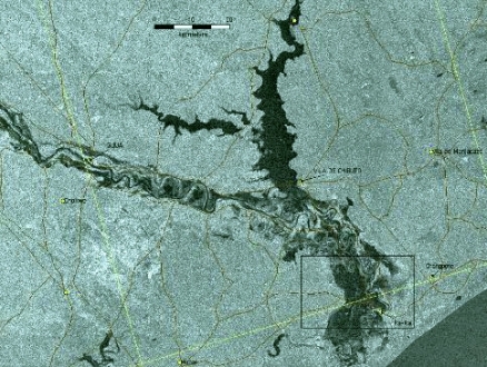
Lower Limpopo near its mouth at flood stage in the noted floods of year 2000. Source: NASA
The Limpopo River is one of the great rivers of southern Africa, with a catchment basin of approximately 410,000 square kilometers. The human population in the Limpopo Basin is approximately fifteen million, with a greater concentration in the lowlands of the downriver portion of the basin; the majority of the basin population is considered to be living in poverty, with the catchment generally overpopulated with respect to land that can be supplied by water for farming.
Topography of the Limpopo River basin. Source: Food and Agricultural Organization (FAO), 2005
The Waterberg Massif and Soutpansberg Mountains are the highest topographic features in the basin, although the larger portion of the catchment is a low lying eastern coastal plain comprising approximately two thirds of the land area of the basin. The majority of the Limpopo Basin incurs less than 40 centimeters of rainfall per annum, with the preponderance of precipitation occurring between October and April; most of the basin is classified as arid or semi-arid.
Contents
Hydrology
At its point of discharge to the Indian Ocean within Mozambique, the mean flow rate of the Limpopo is 170 cubic meters per second. Flow of the Limpopo is generally languid, and the river carries a heavy silt load. The Limpopo headwaters are considered to arise at the confluence of the Marico River and the Crocodile River within South Africa's Limpopo Province; thence the Limpopo flows north to create a portion of the border with Botswana where it arcs eastwardly, to be joined with flow from the Shashe River, establishing the border with Zimbabwe. Thereafter, the Limpopo proceeds down the Great Escarpment eastward into Mozambique at Pafuri, and finally flows across a coastal plateau to the Indian Ocean at Xai Xai.
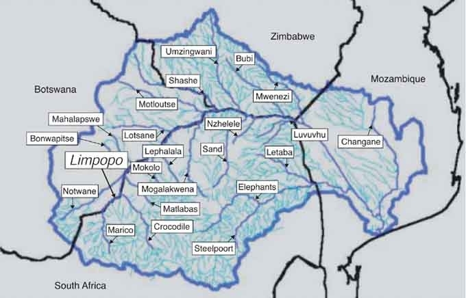
Major rivers and streams within the Limpopo River Basin. Source:Food and Agricultural Organization (FAO).
There are a total of 24 chief tributaries of the Limpopo (see above). The main catchments are shown below.
| Catchment | Area (km2) |
Mean Annual Precipitation (mm) |
Mean Annual Evaporation (mm) |
| Mahalapswe | 3 385 | 454 | 2 000 |
| Lephalala | 4 868 | 513 | 2 328 |
| Lotsane | 9 748 | 430 | 2 000 |
| Mogalakwena | 20 248 | 386 | 1 902 |
| Motloutse | 19 053 | 430 | 2 000 |
| Shashe | 18 991 | 485 | 2 154 |
| Umzingwani | 15 695 | 475 | 2 065 |
| Sand River | 15 630 | 384 | 1 690 |
| Nzhelele | 2 436 | 422 | 2 160 |
| Bubi | 8 140 | 315 | 2 427 |
| Luvuvhu | 4 826 | 715 | 1 635 |
| Mwenezi | 14 759 | 465 | 1 810 |
| Elephants | 70 000 | 500 | 1 700 |
Source:Food and Agricultural Organization (FAO)
In the upper reaches within South Africa and Botswana, the Marico, Crocodile and Mogalakwena Rivers are the largest influent sources. In the middle reaches of eastern Botswana, southeastern South Africa and Zimbabwe, the chief tributaries are the Shashe, the Umzingwane and the Sand Rivers. In the lower reaches, major inflows are from the Mwenezi, Changane and Elephants Rivers. Significant periodic flooding occurs along the lower reaches of the Limpopo in Mozambique, during the rainy season.
Water quality
Elevated nitrate levels are found in portions of the Limpopo Basin, most notably in elements of the groundwater basins. For example aquifers in the Bochum Province of South Africa have been analyzed, with the results of high nitrate and elevated organic carbon. One hypothesis is that injection of untreated sewage to the aquifer accounts for both phenomena.  African elephants at the Sand River, a Limpopo tributary. @ C.Michael Hogan
The Changane catchment has been shown to be significantly polluted due to point source discharges leading low dissolved oxygen and high total dissolved solids, electric conductivity, total hardness, sodium adsorption ratio and low benthic macroinvertebrates taxa. At the most upstream elements of the Mozambique reaches of the Limpopo The water quality monitoring data indicates that sites located at proximities to the border with upstream countries are contaminated with heavy metals.
Water quality issues are exacerbated by the periodic droughts, but also from over-extraction of rivers in the Limpopo Basin, due to overpopulation and over-intensive farming relative to available basin water resources. For example, abstraction of surface water in the Luvuvhu River, a tributary of the Limpopo, in the Kruger Reserve, has led to diminished water qualtiy, and in some cases virtual cessation of flow and severe adverse impacts to aquatic and riparian biota.
Aquatic biota
 Redbreast tilapia, native to the Limpopo. @ Frederick Hermanus Van der Bank Some of the largest native demersal vertebrate fishes of the Limpopo River system include the 117 centimeter (cm) long tiger fish (Hydrocynus vittatus) and the 175 cm African mottled eel (Anguilla bengalensis labiata), the 35 cm snake catfish (Clarias theodorae) and the 32 cm bulldog (Marcusenius macrolepidotus). Demersal river fish are found at the river bottom, feeding on benthos and/or zooplankton.
Some of the larger notable native benthopelagic fishes in the Limpopo are: the 48 cm Mozambique tilapia (Oreochromis mossambicus), the 45 cm Redbreast tilapia (Tilapia rendalli), the 51 cm purple labeo (Labeo congoro) and the 49 cm papermouth (Barbus mattozi). Benthopelagic fish inhabit the water column niche immediately above the bottom, feeding on benthos and/or zooplankton.
Alien species that have been introduced into the Limpopo Basin include the following fishes: Oreochromis niloticus, Oreochromis machrochir, Cyprinus carpio, Micropteris salmoides and M. dolomica.
Terrestrial ecoregions
The ecoregions within the Limpopo catchment span portions of the countries of Botswana, South Africa, Zimbabwe and Mozambique. Special ecosystems within the basin include pans and vleis. A pan is a depression in the local topography, where rainwater collects and typically evaporates prior to discharge to a surface channel. A vlei is a location where the water table is high, and ephemeral or permanent wetlands may exist. Most of the Limpopo Basin wetlands are in the lower reaches of the river along the Mozambique floodplains.

Ecoregions of the Limpopo watershed. Source: World Wildlife Fund.
- Maputaland coastal forest mosaic
- South Zanzibar-Inhambane coastal forest moasaic
- Southern Miombo woodlands
- Zambezian halophytics
- Zambezian and mopane woodlands
- Drakensberg montane grasslands woodlands and forests
- Southern African bushveld
- Kalahari acacia-baikiaea woodlands
- Highveld grasslands
The Maputaland coastal forest mosaic exhibits high faunal diversity and endemism. More than 470 bird species are found here and four species and 43 subspecies endemic or near endemic. The endemic Neergaard’s sunbird (Nectarinia neergaardi) is particularly interesting, as it is restricted almost entirely to the dry semi-deciduous sand forest of Maputaland. Rudd’s apalis (Apalis ruddi) is also near endemic, together with the pink-throated twinspot (Hypargos margaritatus), and the lemon-breasted seedeater (Serinus citrinipectus).
The herbaceous component of Zambezian and mopane woodlands differs according to edaphic conditions and vegetation structure: dense swards are found underneath gaps in the mopane canopy on favorable soils, whilegrassland species are almost completely absent in shrubby mopane communities on heavy, impermeable alkaline clays. Typical grasses include Aristida spp., Eragrotis spp., Digitaria eriantha, Brachiaria deflexa, Echinochloa colona, Cenchrus ciliaris, Enneapogon cenchroides, Pogonarthria squarrosa, Schmidtia pappophoroides, Stipagrostis uniplumis, and Urochloa spp.
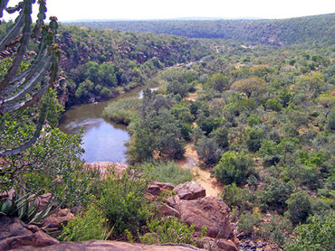 Lapalala River flowing through South Africa bushveld, Waterberg Massif. @ C.Michael Hogan
The Southern African bushveld contains numerous charismatic mammals and a variety of plant species. The savanna covering the Waterberg Mountains is characterized by African beachwood (Faurea saligna), common hookthorn (Acacia caffra), red seringa (Burkea africana), Terminalia sericea, and Peltophorum africanum. The rugged, rocky slopes of these mountains are dominated by white seringa (Kirkia acuminata), stemfruit (Englerophytum magalismontarum), Combretum apiculatum, C. molle, and common sugerbush (Protea caffra).
Deciduous tree and bush savanna covers most of the [[Kalahari acacia-baikiaea woodlands] ]ecoregion, in the sandveld area. Taller trees are mainly confined to low sand ridges and are dominated by Terminalia sericea, Peltophorum africanum, Croton gratissimus, Rhus tenuinervis, Acacia giraffe, A. fleckii, A. luederitzii, Cobretum zeyheri, C. apiculatum, and Ziziphus mucronata. A shrub savanna occurs on the gently rolling plains between the sand ridges and is mainly composed of Dichrostachys cinerea, Grewia flava, G. flavescens, Acacia mellifera, Bauhinia macrantha, Ximenia caffra, and Commiphora pyracanthoides. The grass cover includes Stipagrostis uniplumis, Aristida meridionalis, A. congesta, Eragrostis pallens, E. superba, Heteropogon contortus, Cymbopogon excavatus, and Digitaria eriantha.
Prehistory
The Limpopo Basin is an important locus for early hominids, particularly in the portion of the basin in northern South Africa, including the Waterberg Massif. Considerable rainfall (in earlier ages) and the ability of sandstone to retain ample aquifers provided a hospitable habitat for early man. The table rock formations and cliff overhangs offered natural shelters and even caves for these early peoples. The first human ancestors probably inhabited the Waterberg Massif as early as three million years ago, since Makapansgat, only 40 kilometers to the east has yielded skeletons of Australopicthecus africanus dating above three million years. Homo erectus remains dating to one million years were also discovered in Makapansgat. A. Africanus, subsisting on plants and invertebrates, probably lived on valley floors; however, H. Erectus, a hunter, may have purposefully moved into the higher areas of the Waterberg for summer (December to March) game. At the periphery of the Waterberg in Olieboomsport later Acheulian artifacts were found, indicative of the early stone age. The earliest hard evidence of man in the heart of Waterberg (at Goudriver) is from the Middle Stone Age, where stone tools in cave shelters have been dated at 200,000 to 30,000 BC.
Bushmen from the Botswana region migrated south to the Waterberg around the time of Christ. They left rock paintings at Lapala and Goudriver recording their life and times, including characterizations of rhinoceros, elephant and a variety of antelope species (resembling impala, kudu and eland, all present day inhabitants). Early Iron Age settlers in Waterberg by 450 AD were the Bantu, an advanced tribe skilled in metal-working and cattle herding. The Bantu migrated from Nigeria, but their arrival with cattle created an environmental disaster in the lower plains around Waterberg, since cattle grazing decreased grasses in favour of increasing certain brush species conducive to reproduction of the tse-tse fly. The resulting epidemic of sleeping sickness depopulated the human settlements on the plains, but life on the Waterberg Massif itself thrived, since the fly cannot tolerate altitudes exceeding 600 meters.
References
- William Branch and Tilde Stuart. 2007. Southern Africa: South Africa, Namibia, Botswana, Zimbabwe. 488 pages. Google eBook
- M.Chilundoa, P.Keldermanb, J.H.O´keeffe. 2008. Integrated Water Resources Management: From Concept to Practice. Design of a water quality monitoring network for the Limpopo River Basin in Mozambique. Physics and Chemistry of the Earth, Parts A/B/C. Volume 33, Issues 8–13, Pages 655–665
- FAO. 2004. Drought impact mitigation and prevention in the Limpopo River Basin; A situation analysis.Prepared by the FAO Subregional Office for Southern and East Africa Harare
- Fishbase. 2002. Native fish of the Limpopo River.
- A.H.M.Görgens and R.A.Boroto, 1997. Limpopo River: flow balance anomalies, surprises and implications for integrated water resources management. In: Proceedings of the 8th South African National Hydrology Symposium, Pretoria, South Africa.
- C.Michael Hogan, Mark L. Cooke and Helen Murray, 2006. The Waterberg Biosphere, Lumina Technologies.
- C.J.Kleynhans. 1996. A qualitative procedure for the assessment of the habitat integrity status of the Luvuvhu River (Limpopo system, South Africa). J.of Aquatic Ecosystem Health. 5:41-54
- Shonisani Calvin Mutheiwana. 2007. The assessment of the causes of high nitrate concentrations in groundwater in Bochum district, Limpopo Province. Wits Institutional Repository on Wired Dspace
- U.de V.Pienaar. 1968. The Freshwater Fishes of the Kruger National Park, Koedoe Vol 11, No 1
- Michele L.Thiem. 2005. Freshwater ecoregions of Africa and Madagascar. Island Press. books.google.com 431 pages
- Watkeys, M. K., T. R. Mason, and P. S. Goodman. 1993. The role of geology in the development of Maputaland, South Africa. Journal of African Earth Sciences 16:205-221.
- F.White. 1983. The vegetation of Africa, a descriptive memoir to accompany the UNESCO/AETFAT/UNSO Vegetation Map of Africa (3 Plates, Northwestern Africa, Northeastern Africa, and Southern Africa, 1:5,000,000). UNESCO, Paris. ISBN: 9231019554