Zambezian and Mopane woodlands

Zambezian and Mopane Woodlands are dispersed throughout southern Africa, bounded by the Luangwa River in the north and the Pongola River in the south. Mopane tree (Colophospermum mopane) woodlands mix with Zambezian woodlands in lower-elevation areas, often along major river valleys. Although the ecoregion, particularly the mopane communities, is considered to be low in endemism, it supports some of the largest and most significant wildlife populations in Africa, particularly those of the endangered Savannah Elephant (Loxodonta africana) and critically endangered Black rhino (Diceros bicornis). Important populations of predators are also found in the Zambezian and Mopane Woodlands. The abundance of wildlife can be largely attributed to the high level of protection in the ecoregion, in which more than 45 percent of the habitat is devoted to various forms of state and private conservation. Two cross-border conservation efforts are further increasing the extent of protected lands in the near future.
Location and General Description

Zambezian and Mopane Woodlands are widespread throughout the lower-lying elevations in the eastern half of southern Africa. This ecoregion is characterized by the dominance of the tree Colophospermum mopane (Caesalpiniaceae), which is the sole canopy species throughout much of its range. Elevation and rainfall are the major environmental factors separating Zambezian and Mopane Woodlands from its three major neighboring ecoregions: Central Zambezian Miombo Woodland, Eastern Miombo Woodland, and Southern Miombo Woodland. All three occur on the escarpments and uplands of the Great African Plateau in regions of higher rainfall. Elevation also forms the basis of this ecoregion’s separation from the Southern African Bushveld and Drakensberg Montane Grassland, Woodland, and Forest ecoregions. The Southern Zanzibar-Inhambane and Maputaland Coastal Forest Mosaics form additional boundaries on the coastal zone. Zambezian and Mopane Woodlands diminish in the east, in the region of the Kalahari Sands, where Zambezian Baikiaea Woodlands and Kalahari Acacia-Baikiaea Woodlands are found.
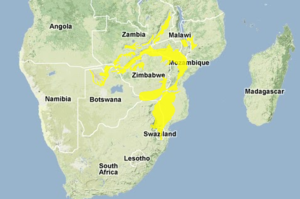
The Zambezian and Mopane Woodlands consist of several discontinuous units in southern Africa. The Luangwa and Pongola rivers define the ecoregion’s northern and southern boundaries, respectively, while the Zambezi River broadly describes the east-west axis. The largest portion of this ecoregion ranges from Swaziland through northeastern South Africa, north through Mozambique, and divides into southeastern Zimbabwe and northern Zimbabwe, along the Zambezi Valley. A smaller portion of the ecoregion runs through northern Botswana and the eastern extremity of Namibia’s Caprivi Strip along both sides of the Kwando River and Zambezi River up through much of Zambia, including the Luangwa Valley in northeastern Zambia. Additional portions occur in southern Malawi in the Shire River Valley area. The ecoregion includes several of southern Africa’s major rivers, occupying the bulk of the Zambezi, Luangwa, Shire, and Limpopo River Valleys. Other regionally important rivers found within the Zambezian and mopane woodlands are the Save, Crocodile, and Nkomati Rivers.
The ecoregion falls largely within the tropical summer rainfall zone, with precipitation largely confined to the period of November to April (White 1983). Annual average rainfall generally varies between 450 millimetres (mm) to 710 mm, although parts of the ecoregion, particularly the higher elevations to the south, may receive up to 1000 mm. Minimum average rainfall may be as low as 250 to 325 mm in certain places. Temperatures range between -4° and 46°C, with a mean annual temperature of 18° to 24°C.
Terrain is generally level or gently undulating along the floors of the major river valleys, with average elevations ranging from 200 metres (m) to 600 m. Parts of the ecoregion occur at slightly higher elevations in rolling or broken terrain above 760 m. The southeastern portion of the Zambezian and Mopane Woodlands occurs on the plains and foothills east of the Drakensberg escarpment, with elevation generally ranging from 170 m to 800 m, although heights of up to 1525 m are attained in places. The ecoregion’s geology is composed primarily of Precambrian granites and gneisses, with basalt and Permian sedimentary rocks being important in certain locales.
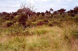
The ecoregion is composed of portions of three of White’s vegetation mapping units falling within the Zambezian regional center of endemism: mopane woodlands and scrub woodlands; north Zambezian undifferentiated woodland and wooded grassland; and south Zambezian undifferentiated woodland and scrub woodland. The first of these units is dominant in the ecoregion, particularly in the central, western, and northern areas, and is characterised by the dominance of the mopane tree. Mopane often forms pure stands to the exclusion of other species, but is generally associated with several other prominent trees and shrubs, such as Kirkia acuminata, Dalbergia melanoxylon, Adansonia digitata, Combretum apiculatum, C. imberbe, Acacia nigrescens, Cissus cornifolia, and Commiphora spp.
Within this area mopane communities show considerable variation in height and density. Trees in dense woodland or in more open savanna woodland may reach heights of 10 m to 15 m on deep alluvial soils, and attain 25 m in the "cathedral mopane" of Zambia. Mopane tends to be stunted and shrubby (one to three m) where it occurs on impermeable alkaline soils. These two structural forms, and grades in between, often occur together in a mosaic depending on micro-climatic factors and soil conditions. Soil conditions may vary, but mopane soils generally possess an impervious B-horizon, or zone of accumulation.
The herbaceous component of mopane communities differs according to soil conditions and vegetation structure: dense swards are found beneath gaps in the mopane canopy on favorable soils, while grasses are almost completely absent in shrubby mopane communities on heavy, impermeable alkaline clays. Typical grasses include Aristida spp., Eragrotis spp., Digitaria eriantha, Brachiaria deflexa, Echinochloa colona, Cenchrus ciliaris, Enneapogon cenchroides, Pogonarthria squarrosa, Schmidtia pappophoroides, Stipagrostis uniplumis, and Urochloa spp.
The eastern and northeastern portions of the ecoregion contain White’s north Zambezian undifferentiated woodlands and wooded grasslands. Here, drier riparian woodlands grow on alluvium with large trees frequently exceeding 20 m in height, with communities of mostly secondary woodland grow on fertile, well-drained, and slightly alkaline soils at elevations intermediate to the river valleys and uplands. This floristically diverse community is distinguished by a lack of dominant species representative of mopane woodland types, and the various miombo communities. Characteristic woody plants are Acacia spp., Albizia spp., Combretum spp., Adansonia digitata, Diospyros mespiliformes, Ficus sycomorus, Kigelia africana, Lonchocarpus capassa, Trichilia emetica, Xanthocercis zambesiaca, and Xeroderris stuhlmannii.
The south Zambezian undifferentiated woodlands and scrub woodlands form the southeastern part of the ecoregion, and are transitional between the Zambezian Center of Endemism and phytochoria to the south. Soils range from sandy loams on crests, to well-structured, often sodic clays on the bottomlands, with black to red clays overlying basaltic or doleritic areas. Important woody constituents of these generally dense communities are Acacia gerrardii, A. nigrescens, A. nilotica, Combretum apiculatum, C. collinum, Dichrostachys cinerea, Kirkia acuminata, Peltophorum africanum, Piliostigma thonningii, Sclerocarya birrea, and Terminalia sericea. Average canopy height within this type ranges from seven to nine m. The herbaceous component is variable: poorly developed in drier areas, and tall and dense where rainfall exceeds 600 mm. In drier areas, grass species such as Themeda triandra, Panicum maximum, Heteropogon contortus, Enneapogon cenchroides, and Urochloa mossambicensis figure prominently, while thatch grass species Hyperthelia dissoluta and Hyparrhenia hirta are important in some of the moister areas.
Biodiversity Features
The flora of the Zambezian and Mopane Woodlands ecoregion is not characterized by high species diversity throughout its range, although White’s two Zambezian woodland types mapped within this ecoregion are considered floristically rich. As many as 2000 vascular plant species have been recorded from South Africa’s Kruger National Park (19,624 km2) in the southeastern portion of the ecoregion. However, plant species richness rarely exceeds 283 species per 625 km2, and only occasionally exceeds 614 species per 625 km2. While greater plant diversity may occur in the Zambezian woodland component of the ecoregion, the mopane tree characterizes the entire ecoregion, and in many places dominates to the exclusion of other species, particularly trees. Mopane trees are ecologically important as browse for numerous animals, notably elephants, and economically the wood is prized for building and fuel. In addition, the tree is the major host for the seasonally abundant mopane worm (Gonimbrasia belina), the larval stage of a moth which is characteristic of the mopane woodlands. The mopane worm is an important human food and economic resource. Other important taxa in the ecoregion are the families Combretaceae and Mimosaceae, which are represented by 34 and 56 tree and shrub species respectively. The extreme south of the ecoregion contains the critically endangered endemic cycads Encephalartos heenanii and E. paucidentatus, which are largely confined to Songimvelo Nature Reserve. The ecoregion is also home to several of the known remaining populations of the medicinally important and severely over harvested perennial herb, wild ginger (Siphonochilus aethiopicus) and the pepperbark tree (Warburgia salutaris).

The Zambezian and Mopane Woodlands are significant from an evolutionary perspective, because the Trans-Botswana transition belt – the transition zone between the tropical and subtropical biomes – broadly corresponds to the mopane vegetation in the southern part of the ecoregion. This belt has played an important role in faunal evolution, as various taxa representative of one biome or the other have dispersed through this zone to speciate on the other side.
This ecoregion is one of the most important areas for vertebrate diversity in southern Africa, particularly for mammals. The biota and associated natural processes remain largely intact as a result of the extensive and well-maintained system of national parks and reserves in the ecoregion. Vegetation here is more nutritive than surrounding ecoregions with higher rainfall, and as a result, the area is well known for supporting large concentrations of ungulates. This includes some of the most significant remaining populations of the critically [[endangered] species] black rhino, the endangered elephant, as well as white rhino (Ceratotherium simum), hippopotamus (Hippopotamus amphibius), buffalo (Syncerus caffer), blue wildebeest (Connochaetes taurinus), giraffe (Giraffa camelopardalis), kudu, and nyala (Tragelaphus angasii). The Zambezian and Mopane Woodlands can be clearly distinguished from moister savannas represented by miombo woodlands based on differences in their faunal assemblages: species such as side-striped jackal (Canis adustus), sable antelope (Hippotragus niger), roan antelope (Hippotragus equinus), and Lichtenstein’s hartebeest (Alcelaphus buselaphus licthensteini) are associated with the miombo, while the black-backed jackal (Canis mesomelas), kudu (Tragelaphus strepsiceros), and impala (Aepyceros melampus) are also characteristic mammals associated with the Zambezian and Mopane Woodlands.
%2c_Timbarati_Reserve%2c_South_Africa.jpg)
Although large blocks of this habitat remain intact, in many areas natural migration routes have been restricted by man-made obstacles, such as the western boundary fence of Kruger National Park and the cattle and veterinary fences in northeastern Botswana. These restrictions on migration have particularly affected movement of the blue wildebeest. The majority of the southern African populations of Lichtenstein’s hartebeest are contained within the Luangwa Valley, Kruger National Park, and Gonarezhou National Park. Sharpe’s grysbok (Raphicerus sharpei), a little known, rare antelope, is well represented in this ecoregion, where it favors dense mopane vegetation.
Predators are also abundant, and the full assemblage of lion (Panthera leo), cheetah (Acinonyx jubatus), spotted hyena (Crocuta crocuta), and leopard (Panthera pardus) is found in a number of the ecoregion’s large protected areas, mostly notably Kruger National Park and its adjoining private reserves. Other important protected areas include the national parks and game management areas of the Luangwa and Zambezi Valleys, and Chobe National Park and Moremi Game Reserve in Botswana. The endangered Painted hunting dog (Lycaon pictus) is found in significant numbers within the protected areas of the ecoregion. Chobe National Park is one of the main breeding sites for the rare slaty egret (Egretta vinaceigula, VU), and the eastern population of the white stork (Ciconia ciconia) utilises the Luangwa Valley as an important wintering ground.
Although the Zambezian and Mopane Woodlands are rich in vertebrate species, they tend to be poor in endemics. Only five birds can be considered near-endemics to the ecoregion: Lilian's lovebird (Agapornis lilianae), black-cheeked lovebird (Agapornis nigrigenis), pink-throated twinspot (Hypargos margaritatus), Chaplin's barbet (Lybius chaplini), boulder chat (Pinarornis plumosus), and lemon-breasted canary (Serinus citrinipectus). One mammal species, Juliana’s golden mole (Amblysomus julianae), is near-endemic. Two endemic ungulate subspecies, Cookson’s wildebeest (Connochaetes taurinus cooksoni) and Thornicroft’s giraffe (Giraffa camelopardalis thornicrofti), are confined to the Luangwa Valley. The ecoregion contains higher reptile endemism, with strict endemics including Lang’s worm lizard (Chirindia langi), collard flat lizard (Platysaurus torquatus), and Sabi quill-snouted snake (Xenocalamus sabiensis).
Elephant browsing activity and fire are the two major natural factors shaping the vegetation palette and associated fauna within the Zambezian and Mopane Woodlands. Elephants crop the larger trees in savannas and woodlands, creating openings exploited by grasses, thus increasing fire frequency and intensity. This interplay between fire and elephants normally results in an open, two-tiered savanna, consisting of large trees interspersed with shrubs at varying stages of growth.
Other amphibians found in the ecoregion include Darling's frog (Hylarana darlingi), whose breeding habitat is met for this amphibian that requires lentic or lotic waters for egg deposition.
Current Status
The Zambezian and Mopane Woodlands are assigned a robust conservation status. The poor agricultural potential of the region means that the majority of habitats are still relatively intact. Some land transformation has occurred, especially in the extreme south of the ecoregion, where relatively dense human populations border Kruger National Park in South Africa. In these areas, as much as 43 percent of the land has been changed (Land-use and land-cover change) by agriculture and settlement, while livestock grazing and resource-use activities heavily impact the bulk of the remaining natural habitat. Aside from the southeastern portion of the ecoregion in South Africa and Swaziland, the majority of Zambezian and Mopane Woodlands occur in areas of low human population density.
The agricultural marginality of the Zambezian and Mopane Woodlands and the large attendant mammal populations have encouraged the establishment of an extensive protected area network in the ecoregion. Government conservation areas protect over 40 percent of the ecoregion with private game ranches, nature reserves, and conservancies in South Africa, Zimbabwe, and Botswana adding a further five to ten percent to the total area conserved. The most significant national parks are Kruger in South Africa, Gonarezhou in Zimbabwe, and Banhine, Gorongosa, and Zinave National Parks in Mozambique. These parks cover much of the large southeastern portion of the ecoregion.
Protected areas in this southeastern portion are scheduled to increase threefold by 2003, with the opening of the 95,700 km2 Gaza-Kruger-Gonarezhou Transfrontier Conservation Area (TFCA), which will join four existing national parks and their intervening lands in South Africa, Mozambique, and Zimbabwe. The Dongola/Limpopo Valley TFCA is another cross-border national park, which will span 4900 km2 of South Africa, Botswana, and Zimbabwe. Other important conservation areas in the ecoregion are the North and South Luangwa National Parks and their surrounding Game Management Areas in the Luangwa Valley, as well as the Zimbabwean and Zambian national parks and game management/safari areas in the Zambezi Valley. Chobe National Park and Moremi Game Reserve conserve a large portion of the ecoregion in Botswana.
Types and Severity of Threats
The most widespread threats to the ecoregion are ongoing habitat fragmentation as well as poaching and exploitation of wildlife. Black rhino and Painted hunting dog are species of special concern; in particular, the endangered Painted hunting dog requires a large unfragmented territory for pack sustainability. Black rhinos continue to be threatened by demands for rhino horn products for export chiefly to China; moreover, Painted hunting dogs are often destroyed by native livestock farmers, some of whom perceive them as pests. In many areas of the ecoregion, poaching is rife due to poor levels of protection provided by local authorities, particularly in Zambia and Mozambique. However, efforts have been made in the past decade to rejuvenate and expand many of Mozambique’s protected areas, so that an improvement in the quality of wildlife protection is occurring in that locale.
Land transformation and degradation through agriculture, settlement, and livestock overgrazing poses some threat to the ecoregion, particularly in South Africa and Swaziland, where population densities are as high as 174 persons per km2 and large-scale agricultural plans have been introduced. In the near future, steadily growing populations (particularly those bordering Kruger National Park) could force the South African government to cede portions of the park and other protected areas to communities demanding space and resources. The Zambezi Valley portion of the ecoregion in Mozambique may also be at risk from the steady influx of people and development as stability returns following the earlier -civil war. The cattle industry in Botswana threatens wildlife populations, as ranching activities supplant indigenous ungulates, destroy predators, and cattle and veterinary fences impede the movements of migratory mammals. Illegal livestock grazing, settlement in protected areas, and uncontrolled bush fires are all threats to the ecoregion in Zambia, as well as the overuse of natural resources exacerbated by a declining economy. Another concern is the potential habitat destruction caused by uncontrolled elephant populations in some parts of the ecoregion, particularly in Botswana and Zambia. Culling and translocations are used to modify elephant populations within protected areas and research into immuno-contraception has also been undertaken.
Invasive alien plants are posing an increasing threat to the ecoregion. Current data from the southeastern portion of the ecoregion show that alien plants cover 0.1 to 5 percent of the entire ecoregion in South Africa and Swaziland, with alien cover exceeding more than 20 percent in places. Among the more prolific invaders are the shrub and tree species Lantana camara and Melia azederach, cacti of the genus Opuntia, and the water weeds Salvinia molesta and Eichornia crassipes. Invasive plants (Invasive species) are supplanting indigenous vegetation and destroying faunal habitats, as well as altering hydrological and nutrient cycles.
The most acute threat to the ecoregion is the present land invasion crisis in Zimbabwe, in which a large percentage of private farms have been occupied since the beginning of 2000. Zimbabwe’s private conservation industry has been particularly affected, notably the large Save Valley and Chiredzi Conservancies in southeastern Zimbabwe near Gonarezhou National Park. The land invasions have coincided with a sharp increase in poaching, which have already caused very large losses to wildlife populations, as well as the application of slash-and-burn farming methods to areas unsuitable for agriculture, particularly in the mopane woodlands and scrub woodlands. Community conservation initiatives, such as the CAMPFIRE program, are also reported to have collapsed in the areas where land invasions have occurred.
Zambia, Zimbabwe, Mozambique and South African portions of the ecoregion all face a fundamental threat by the regional human population explosion. Demand for food and fuel continue to stimulate widespread forest destruction and fragmentation; not only is the demand for housing, infrastructure and agricultural production causing habitat loss, but attendant poaching and genetic pollution are producing biodiversity diminution; genetic pollution produces biodiversity loss in cases such as introduction of domesticated dogs into the home range of the Painted hunting dog.
Justification of Ecoregion Delineation
This ecoregion is defined by the eastern mopane woodlands of the larger Caesalpinoid woodland complex of southern Africa. This ecoregion, particularly from the Okavango to Lake Malawi, reflect White’s ‘Colophospermum mopane woodland and scrub woodland’ and portions of the ‘North Zambezian undifferentiated woodland.’ It is separated from surrounding ecoregions by its lower elevation and rainfall, and is characterized by the dominance of the tree Colophospermum mopane (Caesalpiniaceae), which is the sole canopy species throughout much of its range. The southern boundary diverges from White around the Limpopo River Valley to delineate the higher elevations of Southern Bushveld ecoregion. The southern border of this ecoregion thus encompasses a portion of White’s ‘Northern Zambezian undifferentiated woodland’ stretching around the Limpopo River, towards a section of ‘South Zambezian undifferentiated woodland’ and ‘Transition to Tongaland-Pondoland bushland undifferentiated woodland’ into Swaziland.
This ecoregion is part of larger complex of Caesalpinoid woodland ecoregions that support wet and dry miombo, mopane, thicket, dry forests, Baikiaea woodland, and flooded grassland habitats, among others. The dominance of Caesalpinoid trees is a defining feature of this bioregion (i.e., a complex of biogeographically related ecoregions). Major habitat types (e.g., mopane and miombo) and the geographic separation of populations of large mammals are used to discriminate ecoregions within this larger region. All of these ecoregions contain habitats that differ from their assigned biome or defining habitat type. For example, patches of dry forest occur within larger landscapes of miombo woodlands in several areas. More detailed biogeographic analyses should map the less dominant habitat types that occur within the larger ecoregions.
Further Reading
- CAMPFIRE. 2000. Is CAMPFIRE replacing national parks? Website Retrieved (2001).
- Coates-Palgrave, K. 1983. Trees of Southern Africa. Struik Publishers, Cape Town. ISBN: 1868723895
- Crowe, T.M. 1990. A quantitative analysis of patterns of distribution, species richness and endemism in southern African vertebrates. G. Peters and R. Hutterer, editors. Vertebrates in the tropics. Museum Alexander Koenig, Bonn. ISBN: 3925382321
- CSIR, Division of Water, Environment and Forestry Technology, (undated). The environmental impacts of invading alien plants in South Africa. Brochure produced by the Working for Water Programme, South Africa.
- Cunningham, A.B. 1996. Box 5.1. Pages 107-108 in B. Campbell, editor. 1996. The Miombo Woodlands in Transition: Woodlands and Welfare in Africa. CIFOR, Bogor. ISBN: 9798764072
- Cunningham, A.B. 1988. An investigation of the herbal medicine trade in Natal/KwaZulu: investigation report No. 29. Institute of Natural Resources, University of Natal.
- East, R. 1998. African Antelope Database 1998. IUCN, Gland, Switzerland. ISBN: 2831704774
- Els, H., and J.D.P. Bothma. 2000. Developing partnerships in a paradigm shift to achieve conservation reality in South Africa. Koedoe 43: 19-26.
- Els, H. 1996. Game ranching and rural development. Pages 581-591 in J.D.P. Bothma, editor. Game Ranch Management . Van Schaik, Pretoria. ISBN: 0627021239
- Endrödy-Younga, S. 1978. Coleoptera. In M.J.A. Werger, editor. Biogeography and Ecology of Southern Africa. W. Junk, The Hague. ISBN: 9061930839
- Farrell, J.A.K. 1968. Preliminary notes on the vegetation of the lower Sabi-Lundi basin, Rhodesia. Kirkia 6: 223-248.
- Funston, M. 1993. Bushveld Trees. Fernwood Press, Vlaeberg.
- Grundy, I.M., B.M. Campbell, S. Baleberebo, R. Cunliffe, C. Tafanganyasha, R. Fergusson, D. Parry. 1993. Availability and use of trees in Mutanda Resettlement Area, Zimbabwe. Forest Ecology and Management 56: 243-266. B. Campbell, editor. 1996. The Miombo Woodlands in Transition: Woodlands and Welfare in Africa. CIFOR, Bogor. ISBN: 9798764072
- Harrison, J.A., D.G. Allan, L.G. Underhill, M. Herremans, A.J. Tree, V. Parker, and C.J. Brown. 1997. The Atlas of Southern African Birds - Volume 1: Non-Passerines. BirdLife South Africa, Johannesburg, South Africa.
- Hilton-Taylor, C. 2000. The 2000 IUCN red list of threatened species. IUCN, Gland, Switzerland and Cambridge, UK. ISBN: 2831705657
- Huntley, B.J. 1978. Ecosystem conservation in southern Africa. M.J.A. Werger, editor. Biogeography and Ecology of Southern Africa. W. Junk, The Hague. ISBN: 9061930839
- IUCN 1992. Protected Areas of the World: A review of national systems. Volume 3: Afrotropical. IUCN, Gland, Switzerland and Cambridge, UK. ISBN: 2831700922
- IUCN. 1997/1998. Invaders from Planet Earth. World Conservation 4/97 – 1/98 (double issue). IUCN, Gland, Switzerland.
- Liengme, C.A. 1981. Plants used by the Tonga people of Gazankulu. Bothalia 13: 501-518.
- Low, A.B., and A.G. Rebelo, editors. 1996. Vegetation of South Africa, Lesotho and Swaziland. Department of Environmental Affairs and Tourism, Pretoria, South Africa.
- Masundire, H.M. and J.Z.Z. Matowanyika. 1993. Biological diversity in southern Africa – the path ahead. Report of the Southern African Regional Workshop (28 – 31 March 1993), IUCN. Bulawayo, Zimbabwe.
- Mills, G., and L. Hes. 1997. The Complete Book of Southern African Mammals. Struik, Cape Town. ISBN: 0947430555
- Murphree, M.W. 1990. Decentralising the proprietorship of wildlife resources in Zimbabwe’s communal lands. Centre for Applied Social Sciences, University of Zimbabwe, Harare.
- Network for Environmental and Sustainable Development in Africa (NESDA), 2000. Regional Environmental Action Plan: Zambia. Retrieved (2001).
- Peel, M.J.S., and M. Stalmans. 1999. The Systematic Reconnaissance Flight (SRF) as a tool in assessing the ecological impact of a rural development programme in an extensive area of the Lowveld of South Africa. African Journal of Ecology 37: 449-456.
- Pinhey, E. 1978. Lepidoptera. In M.J.A. Werger, editor. Biogeography and Ecology of Southern Africa. W. Junk, The Hague. ISBN: 9061930839
- The Peace Parks Foundation, 2000a. Gaza/Kruger/Gonarezhou TFCA. Retrieved (2001).
- The Peace Parks Foundation, 2000b. Dongola/Limpopo Valley TFCA. Retrieved (2001).
- Sharman, J., 2000. Zimbabwe’s wildlife falls prey to politics. The Weekly Mail and Guardian (3 November, 2000), South Africa.
- Smith, P.P. 1998. A reconnaissance survey of the vegetation of the North Luangwa National Park, Zambia. Bothalia 28: 197-211.
- Stalmans, M., and A. Emery. 1999. An assessment of the Mpumalanga Parks Board conservation areas in terms of biodiversity and socio-economic value. Unpublished report to the Mpumalanga Parks Board.
- Stuart, S., R. Adams, and M. Jenkins. 1990. Biodiversity in sub-saharan Africa and its islands: conservation, management and sustainable use. Occasional Papers of the IUCN Species Survival Commission. No. 6. IUCN, Gland, Switzerland. ISBN: 2831700213
- Trollope, W.S.W., L.A. Trollope, H.C. Biggs, D. Pienaar, A.L.F. Potgieter. 1998. Long-term changes in the woody vegetation of the Kruger National Park, with special reference to the effects of elephants and fire. Koedoe 41: 103-112.
- Turpie, J.K., and T.M. Crowe. 1994. Patterns of distribution, diversity and endemism of larger African mammals. South African Journal of Zoology 29: 19-32.
- White, F. 1983. The vegetation of Africa, a descriptive memoir to accompany the UNESCO/AETFAT/UNSO Vegetation Map of Africa (3 Plates, Northwestern Africa, Northeastern Africa, and Southern Africa, 1:5,000,000). UNESCO, Paris. ISBN: 9231019554
- Wild, H., and A. Fernandes, editors. 1967. Vegetation map of the Flora Zambesiaca area. Supplement: Flora Zambesiaca. Salisbury.
| Disclaimer: This article contains information that was originally published by the World Wildlife Fund. Topic editors and authors for the Encyclopedia of Earth have edited its content and added new information. The use of information from the World Wildlife Fund should not be construed as support for or endorsement by that organization for any new information added by EoE personnel, or for any editing of the original content. |