Water profile of Lesotho
Contents
- 1 Geography, Climate, and Population
- 2 Economy, Agriculture, and Food Security
- 3 Water Resources and Use
- 4 Irrigation and Drainage Development
- 5 Water Management, Policies, and Legislation Related to water Use in Agriculture
- 6 Environment and Health
- 7 Perspectives for agricultural water management
- 8 Further Reading
Geography, Climate, and Population
Lesotho is a small land-locked mountainous country completely surrounded by the Republic of South Africa. It has a total area of 30,350 square kilometers (km2), a north-south extent of about 230 kilometers (km) and a maximum width of about 210 km. Altitude varies from 1,500 meters (m) to 3,482 m. Lesotho is the only country in the world that is entirely situated above 1,000 m in altitude.
Lesotho is divided into four geographical regions:
- The mountain region covers 18,037 km2 (59 percent of the total area of the country) and is characterized by the bare rock outcrops of the Maluti range and deep river valleys, with elevations of 2,000 m and above;
- The foothills region covers 4,529 km2 (15 percent) and lies at elevations from 1,800 m to 2,000 m between the lowlands and the Maluti mountains;
- The lowland region covers 5,094 km2 (17 percent) and is situated along the western border and consists of a narrow belt of land with elevation of 1,800 m or less and width between 10 and 65 km;
- The Senqu Valley covers 2,690 km2 (9 percent) and forms a narrow strip of land that flanks the banks of the Senqu (Orange) River and penetrates deep into the Maluti Mountains; elevations vary from mountains to lowlands.
 Map of Lesotho. (Source: FAO)
 Lesotho has extensive areas of shrub lands, in particular rangelands, and a modest area of plantation forests (based on Eucalyptus and Pinus), while only less than one percent of the total land area is forest and woodland. In a few almost inaccessible areas, very small patches of Afromontane Forest are preserved, while most areas of forest, woodland, and savanna in the rest of the country have been cleared for agricultural use, which has exacerbated the problem of soil erosion. Land degradation in various forms is a dominant landscape feature in the country, and soils with both management and inherent fertility problems that influence the productivity of both arable land and rangelands are common. Two areas covering together around 6,500 hectares (ha) are devoted to ecosystem protection: Sehlabathebe National Park and Masitise Nature Reserve.
The cultivable land is largely confined to the lowlands and foothills on the Western border and the Senqu River valley in the south. Effectively all the cultivable land in the country, and sometimes more due to encroachment into marginal areas, is currently cultivated. Much of the rest of the land area is utilized for extensive animal farming. In 2002, the cultivated area was 334,000 ha, of which arable land was 330,000 ha, while 4,000 ha were under permanent crops (Table 1). The Food and Agriculture Organization FAO (Food and Agriculture Organization (FAO)) studies predicted a decline of land under cultivation due partly to land going out of production from erosion and partly to settlement expansion around main towns.
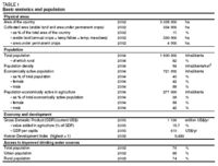 Table 1. Basic statistics and population. (Source: FAO)
 The climate is temperate with cool to cold winters and hot, wet summers. Mean annual rainfall is 788 millimeters (mm) and varies from less than 300 mm in the western lowlands to 1,600 mm in the northeastern highlands. There is substantial seasonal distribution of precipitation and as much as 85 percent of the total can be received during October to April. The Senqu River valley lies in a rain shadow area with some places not receiving more than 600 mm per year. The mountainous regions receive snow during the unusually cold winters. January is the hottest month with maximum daytime temperatures exceeding 30°C in the lowlands. Temperatures on the [[mountain]s] can fall to -20°C in winter.
Distribution of water and reliability of rainfall are serious constraints on agricultural production. Taken as a whole, rainfall in Lesotho is at a level that is adequate to sustain healthy agricultural activity. However, the erratic nature of its distribution is a major constraint for food production:
- The seasonal distribution of precipitation varies considerably and thus the danger of rain falling at the wrong time, or falling too hard, or not falling at all when it is needed, is always present even if total rainfall has been adequate;
- Extreme weather conditions occur periodically; droughts are said to occur three years out of every ten, heavy frosts are frequent and heavy unseasonable rains also occur from time to time;
- Not just the geographical distribution of precipitation, but also the fact that water does not always collect in places where it is immediately accessible for agriculture constitutes a problem; this makes it necessary to build, for example, conveyance infrastructures.
The country has 1.8 million inhabitants (2004) with an annual growth rate of 1 percent (Table 1). Population density is 59 inhabitants/km2, and 82 percent of the population is rural. The lowland is the most populated and intensively cultivated zone followed by the foothills, the [[mountain]s] and the Senqu river valley. Lesotho ranked 132nd out of 178 in the 2002 UNDP Human Development Report and over 49 percent of the population is ranked as poor. Improved drinking water sources are available for 76 percent of the total population, comprising 88 percent of the urban population and 74 percent of the rural population (Table 1).
Economy, Agriculture, and Food Security
Lesotho’s economy is dominated by the services and manufacturing sectors, which in 2003 contributed 40.6 percent and 43.1 percent respectively to the national gross domestic product (GDP) of US$1,100 million. The value added in agriculture was only 15.7 percent of GDP and the sector provided work for 277,000 people, which is 38 percent of the economically active population. Of these agricultural workers, 58 percent were female.
Smallholder farmers whose farms are generally less than 1 ha in size dominate the agricultural production. Maize is by far the most popular crop accounting for some 60 percent of the cropped area, sorghum between 10 and 20 percent, wheat for about 10 percent and beans for a further 6 percent. In late summer, farmers plant wheat and peas on residual moisture, which remain dormant for most of the winter until the first rains in spring.
Although Lesotho’s main natural resource is water, drought chronically affects the country, leading to significant decreases in the contribution of agriculture to the GDP and forcing the country to appeal for assistance from the international community, thus illustrating the vulnerability of the agricultural sector. The country is a persistent net food importer, externally sourcing up to 65 percent of its annual maize requirements and 80 percent of its annual wheat requirements. The scope for increasing food production through area expansion or through higher productivity is extremely limited. Government sees irrigation as a key avenue for increased agricultural production and household food security, as it would enable farmers to intensify and diversify their crop production base. Crops identified for diversification include vegetables and fruits such as paprika, asparagus and apples.
One cannot overemphasize the potential impact of HIV/AIDS on the agricultural sector. Despite the lack of reliable data on the extent and nature of that impact, it is clear that the disease is having a negative and dramatic effect on food security and vice versa. The impact is on labor availability, mobility and productivity, investment in the sector, the retention of knowledge about farming practices, the use of home gardens and the efficiency of the extension services. The burden of work falls on inexperienced younger or older and weaker household members. So HIV/AIDS increases needs at the household level while reversing the impact of efforts to build capacity.
Water Resources and Use
Water Resources
Lesotho is located entirely within the Orange River basin. The major sub-basin river systems in Lesotho are:
- The Senqu (Orange), which drains two thirds of Lesotho (24,485 km2), originates in the extreme north of the country and leaves Lesotho near Quthing. In its catchment area, four large dams will be constructed under the Lesotho Highlands Water Project (LHWP).
- The Makhaleng, with a catchment area of 2,911 km2, originates in the vicinity of Mount Machache and leaves the country near Mohales Hoek.
- The Mohokare (or Caladon) marks the border with South Africa and has a catchment area of 6,890 km2. It springs from Mount Aux Sources, and leaves Lesotho near Wepener. All its major tributaries are located in Lesotho.
The Lets’eng-la-Letsie wetland in the Quthing district was tentatively designated as a RAMSAR site by the Government as part of its accession to the RAMSAR Convention.
Lesotho’s natural renewable water resources are estimated at 5.23 cubic kilometers per year (km3/yr), by far exceeding its water demand (Table 2). Due to Lesotho’s commitments in the framework of the LHWP, its actual water resources will have decreased to 3.03 km3/yr by 2020.
Groundwater resources are estimated at 0.5 km3/yr. Aquifer yields are low: of a sample of 818 wells, only 12 percent yielded above 1 liter per second (L/s); average well depth was 65 m in intrusive, sedimentary or volcanic rock, and 28 m in alluvial rock. In 1995, about 3,300 wells, equipped with hand-pumps, served the rural population in the lowlands, while 10 percent of the urban domestic production originated from groundwater. Except for the area around Maputsoe (aquifer yield 50 L/s), the potential for irrigation with groundwater in Lesotho is low.
Major dams have been constructed in the framework of Phase I of LHWP:
- Katse Dam in the Central Maluti Mountains was completed in May 1997. It is a concrete arch dam, 185 m high, with 710 m crest length and a storage capacity of 1.95 km3. It impounds the Malibamatso River catchment (1,866 km2);
- Mohale Dam is a concrete faced rockfill dam, 145 m high, with 540 m crest length. It impounds the Senqunyane River catchment (938 km2) and has a storage capacity of 0.86 km3;
- Muela Dam, a 55 m high, 6 million cubic meters (m3) capacity dam acts as the tailpond of the Muela hydropower station.
Phases II, III and IV of the project foresee the construction of Mashai Dam (3.3 km3), Tsoelike Dam (2.22 km3), and Ntoahae Dam.
Water Use
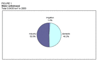 Figure 1. Water withdrawal. (Source: FAO)
 In 2000, the total water withdrawal was estimated at 43.6 million m3 (Table 2 and Figure 1). Industry is the main water user with 22 million m3 (51 percent) followed by the domestic sector with 21 (48 percent) and agriculture with only 0.6 million m3 (1 percent).
International Water Issues
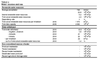 Table 2. Water: sources and use. (Source: FAO)
 The LHWP Treaty was signed by the Governments of Lesotho and of the Republic of South Africa in 1986. The project is aimed at harnessing the water resources of the highlands of Lesotho to the mutual advantage of South Africa and Lesotho, transferring water to South Africa to alleviate its water shortage while providing Lesotho with facilities to generate its own electricity. After completion of all phases by 2020 the project will convey 2.2 km3/yr (66 m3/s) of water to South Africa. The Treaty provides for negotiations to be held between Lesotho and South Africa before further phases of the LHWP can be implemented. Such negotiations are ongoing, and as South Africa has reduced its forecasts for population growth, the water demand is growing more slowly than previously expected and Phase II of the LHWP will start later.
Lesotho, together with Botswana, Namibia, and South Africa, is located in the Orange River basin, and consequently a member of the Orange-Sengu River Commission (ORASECOM) created in 2000.
Irrigation and Drainage Development
Evolution of Irrigation Development
The long-term irrigation potential in Lesotho is estimated at 12,500 ha. In 1996, it was estimated at 2,520 ha for the foreseeable future. The distribution of this latter area over the districts is given in Table 3.
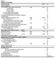 Table 4. Irrigation and drainage. (Source: FAO) Table 4. Irrigation and drainage. (Source: FAO) In the last 40 years there have been many irrigation development projects in the country, almost all of them with funding form external donors. Public sector irrigation development has been largely unsuccessful due to a top-down and supply-driven approach on the part of government and donors and little consultation with, or participation by, farmers. Irrigation systems (mainly large sprinkler systems) have mostly been inappropriate for operation by smallholders as well as expensive to install and to run. As a result, farmer commitment and the overall sustainability of the irrigation works have been poor. Many irrigation schemes have been converted back into dryland farming. The more successful irrigation projects in Lesotho, such as the small-scale irrigation and water harvesting projects, are based on an individual approach to communally owned irrigation schemes, where farmers control the on-field crop production activities. Private irrigation, consisting mainly of home gardens and small market gardens, is successful and is contributing to meeting household food security needs, as well as supplying rural markets. The Ministry of Forestry and Land Reclamation (MFLR) investigated potentially irrigable catchments requiring water storage infrastructures for long-term development and identified 14 areas in the mountain districts of Mokhotlong, Thaba Tseka, and Qacha’s Nek. Out of the 14 areas, six are already operational and MFLR has constructed stone water tanks on some of the sites. Collaboration with the Irrigation Section of the Ministry of Agriculture and Food Security (MAFS) should be forged to improve progress on these sites. The Agricultural Sector Investment Programme (ASIP) intends to improve the viability and sustainability of existing public irrigation schemes by making them more responsive to demand, and, subject to demand, to expand irrigation for fruit and vegetable import substitution, employment creation and enhanced food security. 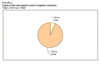 Figure 2. Types of full and partial control irrigation schemes (Source: FAO) Figure 2. Types of full and partial control irrigation schemes (Source: FAO) By 1999, of the 2,637 ha equipped for irrigation only 67 ha were still under operation, and this still relied heavily on government/donor support, although the latter has declined in recent years (Table 4). Of the total equipped area, 175 ha were small schemes (< 100 ha) and 2,462 ha were large schemes (> 100 ha) (Table 4 and Figure 2). In small schemes mostly vegetables are grown and surface and sprinkler systems are used. Large schemes were equipped for sprinkler irrigation, but as the schemes never managed to make a profit, they are no longer irrigated. The two types of irrigation systems commonly used are sprinkler and surface irrigation. Sprinkler irrigation is the most common, while surface irrigation is not so widely used because of the topography of Lesotho. Depending on pressure, three categories of irrigation are distinguished:
Pressures over 25 m are normally produced by engine or motor-driven pumps using petroleum or electricity. Role of Irrigation in Agricultural Production, the Economy, and SocietyVegetables are produced in fairly large quantities under irrigation but production remains very seasonal. The main crop is cabbage, but carrots, spinach and a variety of other crops are also grown. There are both large-scale farmers (often using rented land) and smaller farmers working under irrigation programs. Home gardens are an important source of horticultural produce in Lesotho, where an estimated 70 percent of rural households produce some vegetables. Most home gardens are rainfed, supplemented with irrigation from household and/or community domestic water supplies, although some families have invested in small pumps supplied by streams and ponds. The produce from home gardens is mainly for self-consumption, with limited quantities appearing on the local village market. Vegetable cultivation in the Small-Scale Irrigation Vegetable Project gave a net income of US$2,300/ha in 1992. Yields achieved in various projects range from 1.9 to 3.6 tonnes per hectare (t/ha) for maize, between 3.5 and 13.5 t/ha for potatoes, and from 2 to 11.5 t/ha for onions.
|
||||||||