Water profile of Kazakhstan
Contents
Geography and Population
Basic Statistics and Population
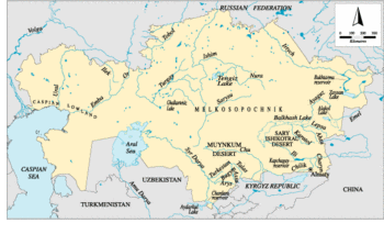 Map of Kazakhstan. (Source: FAO-Forestry)
 Kazakhstan, with a total area of 2,717,300 square kilometers (km2), is the second largest country of the former Soviet Union (FSU) after the Russian Federation. It is located in Central Asia, bordered in the northwest and north by the Russian Federation, in the east and southeast by China, in the south by the Kyrgyz Republic and Uzbekistan, and in the southwest by Turkmenistan and the Caspian Sea. For administrative purposes, the country is divided into 19 provinces (oblasts), one of which includes the capital city of Almaty (former Alma-Ata). It declared its independence from the Soviet Union in December 1991.
Deserts and steppes account for more than 80% of the total area. The central part of the country consists of a sandy plateau with small hills named the Kazakh Melkosopochnik, surrounded in the north and northeast by the west Siberian plain, in the south by the Turan plain, and in the west by the Caspian lowland. In the east and southeast, mountain chains (Altay, Djungar Alatau, Tien Shan) alternate with depressions (Zaisan, Balkhash-Alakol, Ili, and Chu-Talas) which comprise sandy deserts (Sary-Ishikotrau and Muynkum). The country’s highest peak (Khan-Tengry) stands at 6,995 meters (m) above sea level in the Tien Shan mountain range in the southeast.
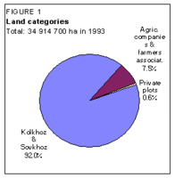 FIgure 1: Land categories. (Source: FAO-Forestry)
 The cultivable area, including the area suitable for pastures/grazing and notably the steppes, is estimated at 222 million hectares (ha), or 82% of the total area. The cultivated area was estimated at 34.4 million ha in 1993, or 15% of the cultivable area, of which 99% consisted of annual crops. Fodder accounts for more than 10 million ha. There has been a dramatic increase in the cultivated area since 1950, mainly due to the political decision taken in 1950 to develop agriculture on semi-desertic land, called ‘virgin land’, notably in the northern and central part of the republic. From 7.8 million ha in 1950, the cultivated area increased to 28.5 million ha in 1960. In 1993, sovkhoz (state farms) and kolkhoz (collective farms) were still predominant in Kazakhstan, with private plots covering less than 1% of the cultivated area, and the joint stock companies and farmers associations less than 8% of the cultivated area (Figure 1). The land reform process was extended further after 1994, and most of the land was transferred to farmers or companies, through private ownership or long-term leases (99 years). With the possibility of selling private land, or transferring land lease, an increase in the average farm size has been reported, up from about 5 ha to more than 7 ha per farm between 1994 and 1997.
The total population is 16.8 million (1996), of which 40% is rural. The average population density is 6 inhabitants/km2, but varies from 2 inhabitants/km2 in the central province of Jeskazgan to 20 inhabitants/km2 in Almaty province. The average annual population growth rate was 1.1% between 1985 and 1990. It then decreased to 0.4% per year between 1990 and 1994, becoming negative in 1993 with a figure of -0.2%. In 1996, about 21% of the economically active population was engaged in agriculture. In 1993, agriculture accounted for an estimated 19% of the gross domestic product (GDP), 7% of which resulted from irrigated crop production, and 28% from rainfed crop production. The remainder (65%) consisted of livestock products, notably beef, mutton, dairy products, and wool.
Climate and Water Resources
Climate
The climate of Kazakhstan is typically continental, with cold dry winters and hot dry summers. In the south, average temperatures vary from -3°C in January to 30°C in July. In the north, average temperatures vary between -18°C in January and 19°C in July, while records show temperatures of -45°C in January. The frost-free period varies between 195 and 265 days in the south and between 245 and 275 days in the north. The cropping period is limited to one season from March to October in the south and from April to September in the north.
The average annual precipitation is estimated at 344 millimeters (mm), ranging from less that 100 mm in the Balkhash-Alakol depression in the central-eastern part of the country or near the Aral Sea in the south, up to 1,600 mm in the mountain zone in the east and southeast of the country. About 70-85% of the annual rainfall occurs during the winter season, between October and April.
The continental climate is also characterized by its high evaporation level, which, together with the low rainfall, makes irrigation a necessity in large parts of the country, notably in the south.
In the [[mountain]ous] zone in the southeast, there are 2,724 glaciers with a total area of 1,963 km2.
River Basins and Water Resources
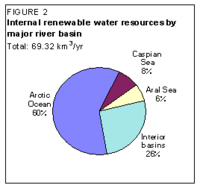 Figure 2: Internal renewable water resources. (Source: FAO-Forestry)
 Four major hydrologic regions can be distinguished in Kazakhstan, depending on the final destination of water: the Arctic Ocean through the Ob River, the Caspian Sea, the Aral Sea and internal lakes, depressions, or deserts.
The total internal renewable surface water resources of Kazakhstan are thus estimated at 69.32 cubic kilometers per year (km3/year), while the total incoming flow from neighboring countries is estimated at 34.19 km3/year (Figure 2). The outflow to the Russian Federation is estimated at 38.8 km3/year, while the total outflow to the Aral and Caspian seas is estimated at 1.5 and 5 km3/year respectively.
International agreements have addressed the water allocation issues between Kazakhstan and its neighbors:
- For the Syr Darya River, the existing principles governing water sharing among the Central Asian countries will remain valid (Agreement of 18 February 1992) until the adoption of a new water strategy for the Aral Sea basin, endorsed by the Interstate Commission for Water Coordination. Under the 1992 Agreement, the part of the Syr Darya surface water resources allocated to Kazakhstan has to be no less than 10 km3/year downstream of the Chardara reservoir. Considering the 4.5 km3/year of internal surface water resources generated in the Kazakh part of the Syr Darya River basin, it can be considered that the actual surface water resources in the Kazakh part of the Syr Darya basin are about 14.5 km3/year.
- For the Chu and Talas rivers, flowing in from the Kyrgyz Republic, an interstate agreement has been reached with the Kyrgyz Republic (May 1992). This agreement addresses the water allocation issues between both republics, considering the total resources generated in the basin (including surface water, groundwater, and return flow) and taking into account the water evaporated from the lakes and reservoirs. On average, it can be considered that the part of the surface water resources allocated to Kazakhstan is 1.24 km3/year for the Chu basin and 0.79 km3/year for the Talas and Assa river basins.
The annual renewable groundwater resources of Kazakhstan are estimated at 35.87 km3/year (1993), of which 29.77 km3/year corresponds to the overlap with the surface water resources. The total annual renewable water resources can thus be estimated at 109.61 km3/year. In 1993, the part of groundwater resources which could be extracted from existing pumping facilities was estimated at 6.1 km3/year.
Non-conventional Sources of Water
About 1.3 km3 of Caspian Sea water is desalinated by the Mangistau nuclear power plant (1993), mainly for industrial purposes and to supply water to the cities of Mangistau and Novi Uzen.
In 1993, the return flow within Kazakhstan amounted to 8.62 km3/year, including 6.79 km3/year of agricultural drainage water and 1.83 km3/year of domestic and industrial wastewater. The main part of the return flow, about 6.78 km3/year, flows back to rivers. About 1.57 km3/year is directed to natural depressions, and 0.27 km3/year is directly re-used for irrigation. In the Syr Darya River basin, about 1.2 km3/year of return flow flows back to rivers while 0.7 km3/year is directed to natural depressions.
Lakes and Dams
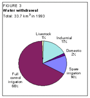 Figure 3: Water withdrawal. (Source: FAO-Forestry)
 The Caspian Sea is the largest lake in the world. Its level is presently subject to important variations. In the last decade, the Caspian Sea level has risen by about 2 m, which has resulted in waterlogging in towns and villages, and the loss of agricultural land. On the other hand, the Aral Sea has been affected by a dramatic decrease in its level and volume, mainly due to irrigation development upstream. This has resulted in environmental problems, which have been tentatively addressed by the Central Asia Interstate Commission on Water Coordination.
There are more than 17,000 natural lakes in Kazakhstan, with a total area of about 45,000 km2 and a total volume of water estimated at about 190 km3. Salinity varies from 0.12 grams/liter in east Kazakhstan to 2.7 grams/liter in the central part of the country. More than 4,000 lakes are inventoried as saline. The largest lakes are: Lake Balkhash, with an area of 18,000 km2 and a volume of 112 km3; Lake Zaisan, with an area of about 5,500 km2; and Lake Tengiz, with an area of 1,590 km2. Irrigation development in the last 20 years in the basin of the Ili River, which flows into Lake Balkhash, has led to ecological problems in the region, notably the drying up of small lakes. For the whole country, it is estimated that about 8,000 small lakes have dried up in the recent past due to overexploitation of water resources.
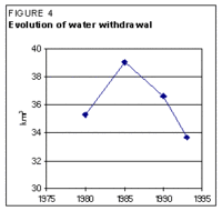 Figure 4: Evolution of water withdrawal. (Source: FAO-Forestry)
 The main natural depression is the Arnasay depression where Lake Aydarkul, with a capacity of 30 km3, was created artificially with water released from the Chardara reservoir and with the return flow from the Hunger steppe irrigated land which is shared with Uzbekistan.
More than 180 water reservoirs have been constructed in Kazakhstan, for a total capacity of 88.75 km3. There are 19 large ones, with a capacity higher than 0.1 km3 each, accounting for 95% of the total capacity. Most of them are multipurpose: hydropower production, irrigation, and flood control. The largest reservoirs are: the Bukhtarma reservoir on the Irtysh River, with a total capacity of 49 km3; the Kapchagay reservoir on the Ili River in the Balkhash basin, with a total capacity of 28.1 km3; and the Chardara reservoir on the Syr Darya River at the border with Uzbekistan with a total capacity of 5.7 km3.
The gross theoretical hydropower potential of Kazakhstan is estimated at 110,000 gigawatt hours per year (GWh/yr) and the economically feasible potential at about 35,000 GWh/year. The total installed capacity of the hydropower plants exceeds 3 gigawatts (GW). Hydro-electricity represents 12% of total electricity generation of the country, which meets only 85% of the total electricity demand, the remainder being imported from neighboring countries.
Water Withdrawal and Wastewater
 Figure 5: Origin of water used by sector. (Source: FAO-Forestry)
 In 1993, the total annual water withdrawal was estimated at 33.67 km3, of which more than 80% was for agricultural purposes (Figure 3). After a regular increase in water withdrawal till the mid-1980s, there has been a slight decrease during the last decade, mainly in the agricultural sector due to the adoption of water conservation methods, and in the industrial sector, due to the decline in the sector since independence (Figure 4). The main source of water is surface water, which is used for agriculture, while the domestic sector is supplied by groundwater and desalinated water (Figure 5). Groundwater is mainly used in the Irtysh River basin (0.6 km3/year), in the Lake Balkhash basin (0.5 km3/year) and in the Syr Darya River basin (0.5 km3/year).
In 1993, the total produced wastewater amounted to 1.8 km3/year, of which 0.27 km3/year was treated.
Irrigation and Drainage Development
Irrigation Development
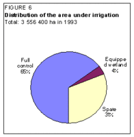 Figure 6: Distribution of the area under irrigation. (Source: FAO-Forestry)
 In 1993, irrigation covered 3.5 million ha, or over 10% of the cultivated area, and provided about 20% of the country’s crop production. Irrigation in Kazakhstan consists of full control irrigation (also called ‘regular irrigation’) on 2,313,100 ha, followed by spate irrigation on 1,104,600 ha, and equipped wetland and inland valley bottoms of 138,700 ha (Figure 6).
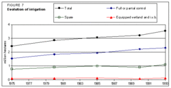 Figure 7: Evolution of irrigation. (Source: FAO-Forestry)
 The evolution of the irrigated area in the last 20 years has shown a progressive and constant increase in the areas equipped for full control, while spate irrigated areas and equipped wetland and inland valley bottoms registered a slight decrease at the beginning of the 1990s (Figure 7).
About 45% of the spate irrigation area is located in the Caspian Sea basin. The equipped wetland and inland valley bottoms are spread throughoutthe country, and are mainly cultivated as pastures or for hay.
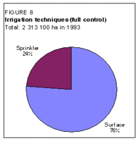 Figure 8: Irrigation techniques. (Source: FAO-Forestry)
 The area equipped for full control irrigation is mainly concentrated in the south of the country, particularly in the Syr Darya River basin (32% of the total) and in the Chu and Talas river basins (10%). The irrigation potential assessment has been based on the areas which could be equipped for full control irrigation at the horizon of 2010. This is estimated at an additional 1,455,400 ha, which leads to a total irrigation potential of 3,768,500 ha.
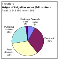 Figure 9: Origin of irrigation water. (Source: FAO-Forestry)
 Surface irrigation is the main technique used in full control irrigation (Figure 8). Sprinkler irrigation, which is the dominant irrigation technique in the northern provinces, covers about 550,000 ha. Micro-irrigation is rare, and generally carried out on a experimental basis. There were about 20,000 ha using drip irrigation in 1990, but they have since been abandoned because of a lack of funds for maintenance.
Full control irrigated areas are mainly supplied with surface water (Figure 9). On about 600,000 ha, water is provided through pumping in rivers. An important hydraulic infrastructure exists in Kazakhstan: the Kirov Interstate canal, constructed at the beginning of the century (from 1913 to 1957) to irrigate the Hunger steppe. The operation and maintenance (O&M) of this canal, which has a capacity of 220 m3/s at his head and a length of 137 km, is the task of the Syr Darya River BWO. The Irtysh-Karaganda canal was constructed between 1962 and 1974 to supply the water-scarce region of Karaganda with the Irtysh waters. Its total length is about 458 km and its capacity is 76 m3/s. More than 22 pumping stations and 14 small reservoirs have been built on this canal, which raises water over a total elevation of 250 m. It is estimated that there are more than 14,000 km of inter-farm canals in Kazakhstan.
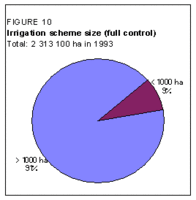 Figure 10: Irrigation scheme size. (Source: FAO-Forestry)
 There is no fully private irrigation in Kazakhstan. Large-scale schemes, with an area of more than 1,000 ha, cover 2.1 million ha (Figure 10). They are managed by state organizations. Small-scale schemes are managed by local (district) water management bodies, which are now self-supporting and financially autonomous. According to a 1996 World Bank report, maintenance is deficient and declining due to staff cuts and shortages of funds. The irrigation efficiencies are very low, due to seepage in unlined canals, resulting in water losses and waterlogging of adjacent lands. Water scheduling is quite rigid, leading in some cases to over-irrigation and a rise in the water table.
Each farm has a fixed and registered water allocation. During water shortages, water is pro-rated according to the crop water requirement norms: higher value cash crops usually have first priority.
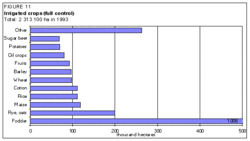 Figure 11: Irrigated crops. (Source: FAO-Forestry)
 Since 1993, a privatization process has resulted in land being leased to joint stock companies and private individuals. The first WUAs were established in 1996, but private forms of water service (delivery and management) are still not operational in Kazakhstan. In 1994, Kazakhstan was the first Central Asian country to implement water fees. The price of water, which is different for each province, was defined by volume and according to the added value irrigation could bring to agricultural production. However, the actual price was fixed well below the price which would have enabled full O&M cost recovery. For example, in 1995, in the Kyzyl Orda province, in the south in the Syr Darya basin, the actual price was fixed at $US 0.06/m3 although the real cost of O&M would require $US 0.56/m3. This low price has not stimulated farmers to adopt water saving techniques. There are few incentives for reduced water use. However, in the case of overuse of water, fines up to five times the cost of the water used above allocation are imposed on farmers.
The major irrigated crops are fodder (mainly alfalfa), cereals, cotton, fruits, potatoes, and sugar beet (Figure 11).
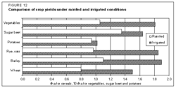 Figure 12: Comparison of crop yeilds under rainfed and irrigated conditions. (Source: FAO-Forestry)
 Wheat, rice, cotton and potatoes are the major Kazakh export crops. In 1993, irrigated crop yields were 1.81 tons per hectare (t/ha) for cotton, 1.5 t/ha for wheat, 4.3 t/ha for rice, 3 t/ha for maize, and 2.5 t/ha for grapes (Figure 12). Fodder crops, which are required for winter feeding of the large livestock population, are grown in many areas where salinity and poor drainage conditions prevent other crops from being grown. The fodder crop yields have declined 15-40% in the last five years.
Irrigation schemes for rice with unlined canals, which are predominant along the Syr Darya River in the south, cost about $US 3,500-5,000/ha, but might require an additional $US 5,000-11,000/ha if agriculture infrastructure is needed. Furrow irrigation systems in the south cost about $US 3,700-5,800/ha. Sprinkler irrigation in the center of the country costs about $US 5,500-7,200/ha. Between 1985 and 1990, the average cost of irrigation development, including the cost of dams, pumping stations, main canals, infrastructures, and drainage networks, was about $US 18,000/ha. Rehabilitation costs vary between $US 3,500 and 4,200/ha.
Waterlogging, Salinity, and Drainage Development
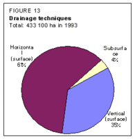 Figure 13: Drainage techniques. (Source: FAO-Forestry)
 Out of the total irrigated area of 2,313,100 ha in the country, over 700,000 ha require drainage. In 1993, drainage had been developed on 433,100 ha. The area equipped with subsurface drains amounts to 15,600 ha, while vertical drainage is carried out on about 152,900 ha (Figure 13). These two drainage techniques have been developed in the newly reclaimed areas, i.e., the Hunger steppe, the Kyzylkum scheme, and the Kyzyl-Orda scheme, all of them in the south of the country. Almost all the drained areas (99%) are located in the five southern provinces of the country. The average cost of drainage development is about $US 600/ha for surface drains and $US 1,400/ha for subsurface drains.
Little maintenance has been done on the drainage network since 1990. Moreover, part of the agricultural drainage system does not work properly because of deficiencies in design and construction. It is estimated that about 90% of the vertical drainage systems are not in use due to the high costs of pumping. A significant problem also exists with the disposal of highly mineralized water.
In 1993, about 242,000 ha (10.5%) of the irrigated areas were classed as saline by Central Asian standards (toxic ions exceed 0.5% of total soil weight). These areas are mainly concentrated in the south of the country.
Institutional Environment
The State Committee for Water Resources of the Republic of Kazakhstan (SCWR) is responsible for maintaining and operating the existing inter-farm system for delivery of irrigation and rural drinking water through regional and district water resources committees. It is responsible for inter-sector and inter-provincial water allocation and for defining national policies on water quality and the protection of water resources. It administers international river systems with respect to water sharing. It supervises the eight national River Basin Water Organizations, which are the Aral-Syr Darya, Balkhash-Alakol, Irtysh, Ishim, Nura-Sarysu, Tobol-Turgay, Ural-Caspian, and Chu-Talas BWOs.
The Ministry of Agriculture is in charge of agricultural research and extension, and on-farm agricultural, and land reclamation development. This ministry is also responsible for the monitoring of drainage, waterlogging, and soil salinity conditions for the major irrigation projects in the five southern provinces.
The Ministry of Municipal Affairs is in charge of domestic water supply and wastewater treatment, while the management of the main water supply network at the provincial and inter-provincial levels falls within the mandate of the SCWR.
The Ministry of Geology and Protection of Underground Resources, the Ministry of Ecology and Biological resources, and the Hydrometeorological Service are also involved in the water sector.
The Water Code, adopted on 31 March 1993, provides the framework for the regulation of domestic, industrial, and agricultural water use, ensuring the respecting of environmental water requirements. It also opens the way for the introduction of a market economy in irrigated agriculture, since it allows the creation of WUAs at the inter-farm level and the privatization of the district water organizations. Irrigation infrastructure (on-farm network, inter-farm secondary network, and equipment/machinery) may also be privatized.
Trends in Water Resources Management
Kazakhstan is very much concerned about water quality. At the international level, Kazakhstan collaborates with the Russian Federation on this issue for the Irtysh, Ishim, Tobol and Ural rivers. Kazakhstan is also working with Azerbaijan, Iran, and the Russian Federation on the Caspian Sea waters. Here the issues include oil extraction, boundary definitions, fisheries, and the proposal for a program to address the rising level of the Caspian Sea.
Kazakhstan’s Caspian lowland is directly affected by the rising level of the Caspian Sea. The economic and environmental consequences of this rise are numerous. Kazakhstan is asking its neighbors and the international community to take or finance mitigating measures in view of protecting coastal areas, agricultural areas and human settlements from flooding. The creation of levees, dams, and polders are among the measures envisaged. On the other hand, Kazakhstan is also concerned about the drying up of the Aral Sea.
The national water strategy, which has been prepared recently within the framework of the regional water strategy, has defined the main objectives of the country which are:
- improvement of the water quality
- supply of clean drinking water to the population
- optimization of the flow regime for the transboundary resources
- implementation of measures to stop the drying up of the Aral Sea, particularly its northern part
This last objective comprises: the rehabilitation of the Syr Darya delta in order to stabilize the coastal zone; increasing the Syr Darya River capacity, notably downstream of the Chardarya reservoir where the capacity is a constraint; construction of a dam (Berg Strait) to stabilize and increase the level of the northern part of the Aral Sea.
The government is interested in privatizing the O&M of the inter-farm systems. Although the on-farm system of O&M was the responsibility of the farm, the funds were previously provided by the state. Because these funds are no longer available, maintenance of on-farm facilities has been neglected. Sprinkler irrigation, covering about 667,000 ha in 1990, fell to about 550,000 ha in 1993. According to a World Bank report, almost 680,000 ha of irrigated land are out of use because of: soil salinization; waterlogging; incomplete distribution systems; improper farming practices; limited inputs such as fertilizers and fuel; and in some instances, lack of water. To address this problem, the government has initiated, on a pilot basis, the transfer of the responsibility for water management to WUAs, which are semi-autonomous. This process will be implemented with the privatization of the irrigated land. The World Bank and the Asian Development Bank will assist the government in this initiative.
Further Reading
- Water profile of Kazakhstan, Food and Agriculture Organization.
- World Factbook: Kazakhstan, Central Intelligence Agency.
- Design Institute ‘Kazgiprovodkhoz’ of the State Committee on Water Resources of Kazakhstan. 1996. Suggestions for national water management strategy of the Republic of Kazakhstan in the Aral Sea basin. Almaty, 180 p. (in Russian)
- Kazinfocenter. 1994. Regional statistic yearbook of Kazakhstan in 1993. Almaty, 551 p. (in Russian).
- State Committee for Water Resources of the Republic of Kazakhstan. 1975 to 1994. Annual reports on land reclamation and water use. Almaty, 200 p. (in Russian).
- State Committee for Water Resources of the Republic of Kazakhstan. 1994. The main figures on water use in Kazakhstan in 1993. Almaty: 36 p. (in Russian).
- World Bank. 1993. Kazakhstan: the transition to a market economy - A World Bank Country Study. Washington, D.C., 234 p. ISBN: 0821326449
- World Bank. 1996. Staff appraisal report, Kazakhstan, irrigation and drainage improvement project. Report 15379-KZ. Washington, D.C., 154 p.
| Disclaimer: This article is taken wholly from, or contains information that was originally published by, the Food and Agriculture Organization. Topic editors and authors for the Encyclopedia of Earth may have edited its content or added new information. The use of information from the Food and Agriculture Organization should not be construed as support for or endorsement by that organization for any new information added by EoE personnel, or for any editing of the original content. |