Southeast Atlantic Forest Reserves, Brazil
| Topics: |
Contents
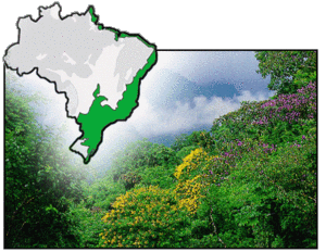
- 1 IntroductionThe Southeast Atlantic Forest Reserves (24º 10'- 25º 40'S and 46º 50'- 48º 44'W.) is a World Heritage Site located in the states of Sao Paulo and Paraná, Brazil. (Southeast Atlantic Forest Reserves, Brazil)
- 2 Geographical location
- 3 Date and history of establishment
- 4 Area
- 5 Land tenure
- 6 Altitude
- 7 Physical features
- 8 Climate
- 9 Vegetation
- 10 Fauna
- 11 Cultural heritage
- 12 Local human population
- 13 Visitors and visitor facilities
- 14 Scientific research facilities
- 15 Conservation value
- 16 Conservation management
- 17 IUCN management category
- 18 Further Reading
IntroductionThe Southeast Atlantic Forest Reserves (24º 10'- 25º 40'S and 46º 50'- 48º 44'W.) is a World Heritage Site located in the states of Sao Paulo and Paraná, Brazil. (Southeast Atlantic Forest Reserves, Brazil)
Geographical location
The nominated World Heritage Site is located in the states of Sao Paulo and Paraná. The area comp.rises the Serra do Mar coastal mountain chain and its associated group of high peaks, small hills, deep valleys and coastal areas. It lies between 24º 10'- 25º 40'S and 46º 50'- 48º 44'W.
Date and history of establishment
The nominated World Heritage Site comprises several protected areas designated at Federal and State levels (Table 1).
 Atlantic Forest Reserves, Brazil. (Source: Convention on Biological Diversity)
 - Part of the area is included in the Mata Atlantica Biosphere Reserve, which was declared as an International Biosphere Reserve by UNESCO-MAB in 1991.
- Inscribed as a World Heritage site in 1999.
|
Table 1: Legally designated protected Areas in the Core Area of the nominated Site. | ||||
|
Name |
Designation |
Level |
Area |
Law/Decree |
|
Carlos Botelho |
State Park |
|
37,644 |
State Dec. 19,499 |
|
Intervales |
State Park |
|
42,926 |
State Dec. 42,926 |
|
Xituê |
Ecological Station |
|
3,095 |
State Dec. 26,890 |
|
Alto Ribeira |
State Tourist Park (PETAR) |
|
35,884 |
State Law 5,973 |
|
Juréia-Itatins |
Ecological Station |
|
79,270 |
State Law 5,649 |
|
Chauás |
Ecological Station |
|
2,699 |
State Dec. 26,719 |
|
Pariquera-Abaxio |
State Park |
|
2,360 |
State Law 8,873 |
|
Ilha do Cardoso |
State Park |
|
22,500 |
State Dec. 40,319 |
|
Jacupiranga |
State Park |
|
119,000 |
State Dec./Law 145 |
|
Lauraceas |
State Park |
|
27,524 |
State Dec.10,729 |
|
Ilha do Mel |
Ecological Station |
|
2,241 |
State Dec. 5,454 |
|
Guaraguaçu |
Ecological Station |
|
1,150 |
State Dec. 1,230 |
|
Pico do Marumbi |
State Park |
|
2,342 |
State Dec. 7,300 |
|
Superagüi |
National Park |
|
37,000 |
Fed. Dec. 97,688 |
|
Guarequeçaba |
Ecological Station |
|
13,638 |
Fed. Dec. 87,222 |
|
Serras do Cordeiro, Paratiu, Itapuã e Itinga |
EPA (Wildlife Zone) |
|
5,000 |
Fed. Dec. 90,347 & 91,892 |
|
Serras de Arrepiado e Tombador |
EPA (Wildlife Zone) |
|
5,125 |
Fed. Dec. 90,347 & 91,892 |
|
Mangues |
EPA (Wildlife Zone) |
|
11,070 |
Fed. Dec. 90,347 & 91,892 |
|
Serra do Itapitangui (e Mandira) |
EPA (Wildlife Zone) |
|
3,437 |
Fed. Dec. 90,347 & 91,892 |
|
Ilhas oceânicas |
EPA (Wildlife Zone) |
|
93 |
Fed. Dec. 90,347 & 91,892 |
|
Roberto E. Lange |
Tourist Preservation Zone & State Park |
|
2,698 |
State Dec. 5,308 & 4,627 |
|
Serra da Graciosa |
Tourist Preservation Zone & State Park |
|
1,189 |
State Dec. 5,308 |
|
Pau Oco |
Tourist Preservation Zone & State Park |
|
905 |
State Dec. 5,308 |
|
Ilha Comprida |
EPA (Wildlife Zone) |
|
30,817 |
State Dec. 30,817 |
|
Salto Morato |
Private Reserve of Natural Protection |
|
1,716 |
Port. 132/94 |
|
Table 2: Legally designated protected areas in the Buffer Zone of the nominated Site. | |||||||||||||||||||||||||||||||||||||||||||||||||||||||||||||||||||||||||
|
|
|
AreaThe nominated World Heritage Site includes a total extent of 1,691,750 hectares (ha), which is divided into a core area of 468,193 ha and a buffer zone of 1,223,557 ha. Land tenureLand in the core area is owned by the Federal and State governments, except for the private properties designated as Natural Heritage Private Reserves. Ownership in the buffer zone is a mixture of private and public. AltitudeFrom sea level to 1,400 meters (m), at the top of the Serra do Mar Mountain Chain. Physical features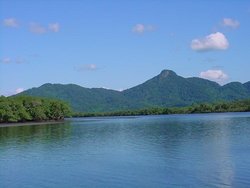 Estuarine Lagoon Complex of Iguape-Cananéira-Paranagua, Brazil. (Source: IBAMA) Estuarine Lagoon Complex of Iguape-Cananéira-Paranagua, Brazil. (Source: IBAMA) The nominated World Heritage Site presents a karstic relief that is characteristic of South-eastern Brazil. It comprises the Serra do Mar Mountain Chain, which runs parallel to the Atlantic coast and separates the Brazilian plateau or Planalto from the lower sea plains. The area is characterized by spectacular mountainous landscapes with deep river valleys and isolated hills. The site also comprises part of the Estuarine Lagoon Complex of Iguape-Cananéira-Paranagua, which includes a great variety of wetlands, from the flooded plains of the Ribeira de Iguape River to saline waters of the lagoon Complex itself. There is also a great extension of beaches showing a succession of opened ocean-sand dunes-sandy strings. The center of the Estuary is the region of Cananéia. These lands are separated from the ocean by an archipelago that runs parallel to the shoreline and comprises the islands of Comprida, Cananéia, Cardoso, Superagüi, Laranjeiras, Peças and Mel. In the interior, the three following formations can be identified: (a) Plateau or Planalto, which corresponds to the upper portions of the ridges of the Serra do Mar Mountain Chain and is dissected in several points; (b) plateau's scarp, which develops to the west and constitutes the limits of the plateau, which are subjected to erosion by rain and tectonics; and (c) serrania, which is composed by a series of mountain's ridges and hills that are isolated from the plateau or linked to its slopes. The region is the water divide between the upper course of Ribeira de Iguape and Paranapanema rivers. Mountains, serranias and isolated hills include the catchment of these watercourses and a series of cascades, waterfalls and rapids. The Ribeira de Iguape watershed drains the southeast area of Sao Paulo State and the east area of Parana State. The Iporanga and Bethary rivers flow into the Ribeira River and cross Alto Ribeira State Park. Geologically, the region is one of the oldest on Earth and is originated from Tertiary faults and volcanic intrusions. The Serra do Mar Mountain Chain is made up of ore-Cambrian granite porphyries and gneiss magma. There is a series of calcareous massifs that generated a high concentration of karsts, especially on the area of Apiapí, Iporanga and Eldorado Paulista. The Alto Ribeira State Park includes more than 250 horizontal karstic caves and abyssal pits (250 m) in depth). Intensity of rains and high humidity in the region explains the exceptionally large size and degree of development of the caves and associated concretions: stalactites, stalagmites, curtains and pillars. A detailed description of the cave system of the park can be found in Lino and Allievi (1987). ClimateThe region has sub-tropical humid climate. Average temperature in the hottest month is 22°C (February) and 18°C in the coldest (July). Average annual precipitation is 1,200-1,500 millimeters (mm). Rains are well distributed throughout the year and there is not a marked dry season. VegetationThe nominated World Heritage Site contains well preserved remnant patches of highly diverse and endangered (IUCN Red List Criteria for Endangered) Atlantic rainforest. More than 450 species per hectare can be found in some spots, which indicates that the diversity of woody plants in the region is larger than in the Amazon rainforest. Major vegetation types in the nominated Site are tall mountain and lower mountain Atlantic rainforest. Forest canopy along river valleys is taller, with isolated trees reaching up to 30 m in height. Species composition and structure change with altitude, and transitional stages between forest types are linked to soil depth, fertility and humidity. Lower mountain forests grow between 80-900 m of altitude, and is dominated by tall (25-30 m) trees of the families Fabaceae, Lauraceae, Myrtaceae and Euphorbiaceae. Palm-tree Euterpe edulis (EN) grows in lower altitudes. Between 900-1,300 m, there is a low (7-8 m in height) mist forest dominated by Podocarpus sp. and Clusia sp. This forest is extremely rich in epiphytes, terrestrial orchids and bromeliads. Above 1,300 m, grassland dominated by Ciperaciae and Sphagnum, on more exposed and wet areas, is found. A semi-deciduous dry Atlantic forest with numerous exclusive species grows on calcareous [[soil]s]. Along the coast, there are also extensive areas of mangroves and shrubland. Fauna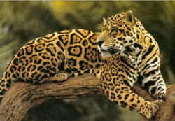 Jaguar, Brazil. (Source: Souther Kings Consolidated Schools) Jaguar, Brazil. (Source: Souther Kings Consolidated Schools) There is a highly diverse fauna with several species of conservation concern. Mammals include 120 species, probably the largest number in Brazil. Some noteworthy species are jaguar Panthera onca (NT), ocelot Leopardus pardalis, bush dog Speothos venaticus (VU), La Plata otter Lutra longicaudis, 20 species of bats and various species of endangered (IUCN Red List Criteria for Endangered) primates, notably muriqui Brachyteles arachnoides (EN) and brown howler Alouatta fusca (VU). The newly discovered black-faced lion tamarin Leontopithecus caissara (CR), is endemic to the area. The bird fauna is very diverse, with 350 recorded species. The area is an important breeding ground for harpy eagle Harpia harpyja (NT), red-tailed amazon Amazona brasiliensis (EN) and black-fronted piping guan Pipile jacutinga (EN), among many others. The system of caves gives shelter to an endemic micro-fauna, mainly arthropods and the blind fish Pimeloda kronei. A detailed list of species of fauna of conservation concern is provided in the official nomination. Cultural heritageMore than 50 archaeological sites were unearthed in the area. These sites contain accumulation of shells, pottery and stone tools. The historic center of Iporanga is characterized by its colonial architecture and includes the well-known Ivapurunduva's 'Quilombo' Chapel. The area is also a center of traditional knowledge on the forest and comprises an African 'Quilombo' population, which still speaks Bantu language and preserves its ancestral uses and costumes. Cananéia is considered an indian settlement dating before the time of discoveries and often considered as the starting place of Peabiru-Trail or way, which served the Inca empire. Local human populationEconomically the region is considered one of the poorest in Sao Paulo and Paraná states and is inhabited mainly by traditional rural communities. The principle economic activities are subsistence agriculture and extraction of forest products. A total 200 families live inside designated protected areas. A further 450 people live in the surroundings of Alto de Ribeira State Park. The town of Cananéia had a population of 7,734 in 1980 while the number of inhabitants in Iguape was 23,363 in 1989. The rural zone has 37% of this population, mainly devoted to fishing, farming and cattle breeding. Private land is generally subjected to different agricultural activities. The size of properties varies from 10 to 200 ha (small farms), 200-1,000 ha for larger farms and even more than 1,000 ha. Visitors and visitor facilitiesThe entire area was visited by around 1.3 million people in 1997. Some of the state parks have information centres and visitor facilities in process to be built. Carlos Botelho and Intervales State Parks are better equipped, with lodging facilities and auditorium. There are two visitor centers in the Alto Ribeira State Park (PETAR) and a third one is being implemented. Camping is allowed on sites near visitor centres. Thirty caves are opened to visitors, but cave excursions are under the responsibility of experienced local guides. Scientific research facilitiesNo detailed information. Conservation valueThe nominated World Heritage Site represents one of the most representative remnant samples of the highly endangered Atlantic Forest, of which only a 7% of its original area exists in Brazil. The site contains the largest indexes of natural vegetation in Brazil. The area gives shelter to several species of conservation concern, such as the jaguar and muriqui, and contains the largest number of karst caves known to exist in Brazil (300). Conservation managementAll the Atlantic forest occurring in Sao Paulo State has been declared under special protection by Resolution No. 40 of 1985 and Federal Decree No. 750/93. The system of caves and karstic formations are protected by Federal Decree 99,556 of 1990. Management plans are being implemented in all protected areas. The management plan of Alto Ribeira State Park (PETAR) was initiated in 1985 and has progressively solved some of the most compelling constraints such as illegal mining, illegal extraction of palm trees and invasions by illegal settlers. The Cananéia-Iguape-Peruibe Environmental Protection Area was regulated in 1996, aiming at the elaboration of a management proposal seeking integrate and consolidate a participate planning process between public organs and local society looking toward the sustainable development. The Guaraqueçaba Environment Protection Area has also a management plan, elaborated in 1995. Several surveys aimed at improving management have been conducted in the region: Forest Inventory of Sao Paulo State (1993), Macrodiagnostic of the Brazilian Coastal Zone (1996), Regulation of Cananéia-Iguape Peruibe Environmental protection Area (1996), Guidelines for an Ecological Tourism State Police (1997) and the Management Plans-Phase I of Ilha do Cardoso and Parquera-Abaixo State Parks and Chauas Ecological Station (1998). Management constraintsIllegal extraction of trees and palms and poaching are serious conservation problems in the region. Deforestation rate is high, especially on the mountaintops and hillsides. Slash and burn agriculture is frequent and contribute to the continuous loss of forest cover. Other conservation problems include mining for calcareous materials, gold and lead, although the latest two are in decline. The official nomination document indicates that many [[coast]al] habitats are threatened, including the hygrophilous forest, the mangrove, the dunes and shoals, [[forest]s] on the seaside plain, the [[swamp][]s and [[lagoon]s]. Many species are illegally used for furniture and buildings. While traditional fishermen do not cause negative impact to fishing resources, there is a serious threat from commercial fishing. Problems of flooding occur sometimes on the lower course of the Ribeira de Iguape River. There is a great industrial and urban development on the axis Sao Paulo-Curitiba. StaffAlthough there is shortage of trained personnel to manage the property, the state system of protected areas has a reasonable number of staff and volunteers in charge of activities of control and surveillance. A total 326 people, 29 directors, 134 rangers and 163 conservation technicians, work in the area. BudgetThe whole region was included in the Programa Nacional do Meio Ambiente - PNMA and has received US$10 million to be used in the implementation of projects of sustainable use of natural resources, environmental education, scientific research and protected area management. Currently, the Programa de Preservaçao da Floresta Atlantica is being developed with Kreditanstalt für Wiederaufbau from Germany. This program, of US$20 million, is intended to improve protected area management performance and to implement the surveillance of the forest in the region. IUCN management category
Further ReadingThe nomination contains the full list of cited references, the most relevant of which are the following:
| |||||||||||||||||||||||||||||||||||||||||||||||||||||||||||||||||||||||