Rio Abiseo National Park, Peru
| Topics: |
Contents
- 1 Introduction
- 2 Geographical Location
- 3 Date and History of Establishment
- 4 Area
- 5 Land Tenure
- 6 Altitude
- 7 Physical Features
- 8 Climate
- 9 Vegetation
- 10 Fauna
- 11 Cultural Heritage
- 12 Local Human Population
- 13 Visitors and Visitor Facilities
- 14 Scientific Research and Facilities
- 15 Conservation Value
- 16 Conservation Management
- 17 IUCN Management Category
- 18 Further Reading
Introduction
Rio Abiseo National Park (7° 23'-7° 24'S, 77° 00'-77° 4'W) is a World Heritage Site located in Peru (Rio Abiseo National Park, Peru) .
Geographical Location
Situated in the Andes mountain chain (Cordillera Oriental de los Andes), to the west of Huicungo on the Amazon slope of the Peruvian Andes. The park is located at a crossroads between the Maranon and Huallaga rivers and covers 70% of the Abiseo River basin. It is located to the east of the city of Trujillo, in the department of San Martin, province of Mariscal Caceres and district of Huicungo. 7° 23'-7° 24'S, 77° 00'-77° 4'W
Date and History of Establishment
Established by Supreme Decree No. 064-83-AG on 11 August 1983, followed by the Resolucion Directoral No. 073-86-AG-DGFF of 31 July 1986. The national cultural heritage site was declared by Law No. 23633 on 1 June 1983. Inscribed on the World Heritage List in 1990.
Area
274,520 hectares (ha).
Land Tenure
State. The community of Los Andes ceded to the park the lands it had claimed within the park on the basis of the Agrarian Reform of 1976.
Altitude
500 meters (m) to 4,200 m.
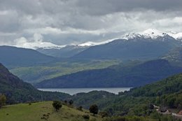
Physical Features
The park encompasses the Abiseo River basin which is surrounded by an orographic system. The major rivers of Maranon and Huallaga, both tributaries of the Amazon, run on either side of the park. On the western border are the Chirimachay, Los Chocos, Manachaqui and Montecristo river valleys. The topography is particularly mountainous to the western boundary of the park, with slopes often greater than 50°. The entire region is typified by very acidic soils, almost all of which have never been disturbed by agriculture or timber extraction. The rock type of the region is largely a Precambian metamorphized mass of sedimentary origin with some areas of Tertiary-Quaternary volcanism, and some sedimentary formations of Late Triassic-Jurassic, Tertiary and Quaternary ages. Deglaciation in the northern Andes begun around 12,000 years ago, when ice began to melt, and complete melting was over by 6,000 years ago.
Climate
High humidity tropical climate, cool at high [[altitude]s. No direct climatic data is available, but according to SENAMHI (n.d.), annual precipitation at the bottom of the Maranon River valley is less than 750 millimeters (mm). From here to the highest elevations, rainfall increases continuously to about 1,500 mm per annum. Mean annual temperatures drop along this same gradient from above 18°C to less than 10°C. According to WWF and IUCN circulation is out of the Amazon basin from east to west and the most rain occurs from November to April when the Intertropical Convergence Zone is south of the equator.
Vegetation
Four ecological zones have been identified around Pataz, namely: dry forest; moist montane forest; tropical alpine forest; and montane rainforest. Dry forest occurs up to about 2,300 m on the sides of the Maranon River valley. Typical tree species include Acacia sp., Parkinsonia praecox (IK), Eriotheca discolor (IK) and Tessaria integrifolia. Moist montane rainforest is found from 2,300 m to 3,600 m and comprises species such as Alnus acuminata, Lomatia hirsuta (IK), Randia boliviana (IK) and Clethra cuneata (IK). Tropical alpine zone straddles the mountain chain, whose valleys are covered by grasslands, which are sedge or shrub dominated wetlands in poorly drained valley bottoms. Principal grass species include Calamagrostis, Cortaderia and Festuca. Montane rainforest with tropical alpine grassland occurs on the eastern side of the mountain range. Typical plants within the forest and grassland boundary include Hedyosmum scabrum (IK), Ilex sp., Miconia sp., Ruagea hirsuta and Weinmannia auriculata (IK). High altitude grassland inventories have resulted in the identification of 1,000 species of plant, among which are 779 angiosperms, two gymnosperms and 159 pteridophytes.
Fauna
The cloud forest supports a wide diversity of fauna with such notable species as turkey vulture Cathartes aura, Andean guan Penelope montagnii, scarlet-fronted parakeet Aratinga wagleri, lyre-tailed nightjar Uropsalis lyra, marvellous spatuletail Loddigesia mirabilis (VU), cock-of-the-rock Rupicola peruviana, carbonated flower-piercer Diglossa carbonaria and hepatic tanager Piranga flava (Mittermeier, de Macedo and Luscombe, 1975). Altitude zonation has strongly influenced the avifauna; there are over 132 bird species between 3,000 m and 4,100 m. More threatened species include nine endemics to the country and five species of restricted distribution, found otherwise only in the northern part of Bolivia. The park is the northern limit for the distribution of a variety of scarce species and a new location for species such as yellow-browed toucanet Aulacorhynchus huallagae (LR). Other notable species include South American pochard Netta erythrophthalma and golden-plumed conure Leptosittaca branickii (VU).
There are several notable mammal species, such as endemic yellow-tailed wooly monkey Lagothrix flavicauda (CR), a species previously believed to be extinct by 1926. Also present are three other species of monkey including long-haired spider monkey Ateles belzebuth (VU), white-fronted capuchin monkey Cebus albifrons cuscinus (DD), night monkey Aotus trivirgatus and howler monkey Alouatta seniculus. Other larger mammals include north Andean huemul Hippocamelus antisensis (DD), spectacled bear Tremarctos ornatus (VU), jaguar Panthera onca, jaguarundi Felis yagouaroundi and possibly tapir Tapirus pinchaque (EN). Other species include giant armadillo Priodontes maximuss (EN), paca Cuniculus paca and prehensile-tailed porcupine Coendou bicolor. Rodents Thomomasomy spp. are highly evident and there are also opossum Didelphis marsupialis and coati Nasua nausua.
Studies of the invertebrates have shown a high level of endemism, a key example being the Ithomiidae. The park is illustrated as a center of evolutionary endemism and a quaternary refuge. The rich herpetological fauna includes 15 unique species of anurans which are highly site specific.
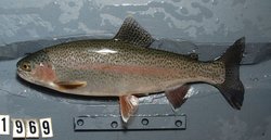
Native aquatic systems were altered in diversity and trophic structure by the introduction of rainbow trout Oncorhynchus mykiss in the 1970's. This exotic species is now the top predator in streams and rivers from 3,600 m to 1,700 m.
Cultural Heritage
Important pre-Columbian ruins extend over 1,500 square kilometers (km2) inside and around the park. The number and variety of archaeological sites found indicate a significant level of human occupation in the past. Since 1985 some 36 archaeological sites have been recorded, 29 in the high elevation grasslands and seven within the continuous montane forests inside the park. Key systematic studies have concentrated on excavations at Gran Pajaten and Manachaqui cave. Types of features include rock shelters, roads, domestic and ceremonial structures, storage buildings, fences, platforms, agricultural terraces and burial sites. Radiocarbon-dating of remains from Gran Pajaten confirm human occupation from the Early Horizon (900-200 BC) through to the Late Horizon periods (1476-1532AD). Manachagui Cave contains stratified cultural deposits that span the latter Paleo-Indian period, and the Preceramic periods (approx 1800 BC to 1532 AD). A pre-Hispanic road system, which once linked Huanuco to the south with Chachapoyas to the north, crosses the western boundary of the park and archaeological sites have been found throughout the zone of influence of this route. The relative inaccessibility of the region protected the archaeological sites from the time of their apparent abandonment in the late 16th century until the modern 'discovery' of Gran Pajaten in 1963. Three sites, Gran Pajaten, Los Pinchudos and La Playa were cleared of vegetation, mapped and partially excavated in the 1960s and 70s, and again in 1985-7, but the rest of the sites have not been investigated in detail.
Local Human Population
There are no major resident populations within the park, but human settlements exist around the park, as on the western boundary. The communities of Los Andes and Pias have been notable for their extensive cooperation with the park authorities. Illegal cultivation and livestock tending still occurs within parts of the park boundaries. Access has improved as a result of dirt track construction from 1960 onwards.
Visitors and Visitor Facilities
Due to the fragility of the archaeological ruins and the lack of park infrastructure, Rio Abiseo has not been open to tourism since 1986. The local authorities have given permission to improve tourist facilities ranging from the construction of a road from Juanjui-Dos to Mayo-Gran Pajaten to the planned development of a tourist hotel at Juanjui, and a museum at Huicungo. As yet the projects have not advanced beyond the planning stage due to a lack of funding. The international division of the US National Park Service has offered the services of a trail specialist, when funding becomes available to construct and mark trails and establish camp sites.
Scientific Research and Facilities
Since 1986 Rio Abiseo has remained closed to all but scientists and support personnel. A wide range of multidisciplinary research studies has been undertaken, from geology and soil studies to archeology, ornithology, mammalogy and vegetation surveys, largely based on the cooperation agreement of the Ministry of Agriculture and the University of Colorado. Research studies have also been undertaken by the Museo de Historia Natural of the Universidad Nacional Mayor de San Marcos and the Servicio Forestal y Caza of the Peruvian Ministry of Agriculture. In 1982 WWF-International provided initial support for field surveys which led to the establishment of the park. WWF-US has supported the park since 1985, providing funds to create an operational structure for the western sector. Archaeological studies have been undertaken by the University of Colorado, in coordination with the National Institute of Culture and the National University of Trujillo. The most recent research includes the preparation of a legal study on the protected area and its surroundings by the Peruvian Society of Environmental Law.
Conservation Value
The principal objectives for establishing this protected area were 1) to protect a representative sample of pristine cloud forest; 2) to protect the Abiseo River basin; 3) to protect endangered (IUCN Red List Criteria for Endangered) animal species; and 4) to protect pre-historic sites. Due to its great importance, Rio Abiseo is among the World Wide Fund for Nature's top Andean conservation priorities.
The cloud forest acts as a Pleistocene refugium of great species diversity and a high degree of endemism. The park contains habitat for at least eight endangered mammal species and is also proving to be an important geobotanical laboratory for studies on pollen and climatic changes in the Amazon basin. The area is also archaeologically significant, since areas harbor cultural remains that span at least 8,000 years of Peruvian pre-history and history.
Conservation Management
The responsible administration is the Direccion General Forestal y de Fauna (DGFF). The National Agrarian University La Molina in 1982 prepared a preliminary master plan, which was the basis for Rio Abiseo River National Park as well as the guide for the first management and protection efforts initiated in 1986. The operative plan for the park was completed in January 1989, outlining steps to be taken for conservation of the natural and cultural resources during 1989-1990. Financial and technical support comes from two main sources: University of Colorado, Boulder, USA and the WWF/IUCN. Funds from the former are being used for species inventories, as well as for the archaeological and palaeo-environmental studies and the operative plan workshop. Since 1982, WWF has provided financial support for park administration, management, protection and education (Projects Nos. 3659 and 6054), through the administration of the Peruvian Foundation for the Conservation of Nature (FPCN) on behalf of the National Directorate of Forestry and Wildlife.
The park has been zoned, identifying areas specifically used for research. Three zones have been recommended for the operational plan: a restricted zone for natural resources research and for the protection of the ruins; a protection and recuperation zone; and a buffer zone outside the park. Prohibited activities include: extraction of firewood, hunting and fishing, cultivation, felling of woodland and burning of pasture, construction of dwellings and the raising of cattle. It is also prohibited to modify or transform the scenic beauty of the park. Because of the fragility of the ruins and limited park infrastructure, Rio Abiseo is not open to tourism. Since public use is significantly restricted, the park is classified more as a strictly scientific reserve than a national park. Control of prohibited activities has improved since the park administrator began work in 1986. Protection measures have reduced illegal hunting especially on the western side of the park. The eastern side is more isolated and suffers less illegal hunting pressure. Throughout 1989, WWF has been supporting an administration post located along the access trail to the park, and plans have been in progress to establish a third guard post on the park's west-central border to control the entry of people and cattle. Park guards are being trained to work with inhabitants of neighboring communities on appropriate use of renewable natural resources. The efforts of the Peruvian Environmental Law Society (SPDA) and park personnel have led to several herders exchanging their cattle livestock for alpacas, which are ecologically less damaging to the local environment and whose grazing requirements do not necessitate the periodic harmful burning of grasslands. The land tenure problems that existed as a consequence of the Agrarian Reform of 1976, an action which resulted in the park being superimposed on the land of the community of Andes de los Alisos, have been resolved through the intervention of the Unidad Agraria Departmental IV - La Libertad and SPDA.
Management Constraints
Illegal hunting has been known to occur in the park but is regarded as uncommon today, the most affected areas in the past being on the western side of the park which led to a drastic reduction of Hippocamelus antisensis. Monkeys, bears, and other animals have been hunted for food and for their skins. Burning of pastures was a medium to serious threat in the high elevations of the western sector of the park, although park managers prohibited grazing and discouraged grassland fires from 1986 with successful results. Habitat destruction on the steep slopes has been reported and [[forest]s] cut down to be replaced by agriculture. Ten families are reported to be growing crops in the montane forest zone of the southernmost valley of the park. Until 1960 no roads entered the region. Subsequently, dirt tracks have been constructed and habitations encroached close to the park boundary. There is currently a proposal for the construction of a highway from the port of Salaverry inland to San Martin, passing only a few kilometers north of the park and which could potentially be disruptive if funding is ever secured to build it. Colonization of the pre-montane forest zone in the park has so far been prevented by inhospitable terrain and distance from roads. However, the area is climatically suitable for growing coca leaves for the illicit and expanding cocaine trade, and more accessible forests outside the park have been affected. Continued degradation threatens the archaeological sites. Gran Pajaten has been cleared several times of vegetation, and the roots of resulting regrowth of bamboo species and light-demanding shrubs cause considerable damage to walls.
Staff
Six park guards and an administrator were listed in 1989, increasing to 11 park guards by 1990.
Budget
Funding from 1985 to 1988 totalled US $626,000 from the University of Colorado in the USA and US $175,000 from WWF. The only direct contribution made by the Ministry of Agriculture is the salary of the park administrator.
IUCN Management Category
- II (National Park)
- Natural/Cultural World Heritage Site - Natural Criteria ii, iii, iv / Cultural Criterion iii
Further Reading
- APECO (n.d.). Parque Nacional Rio Abiseo. Pamphlet prepared by the Asociacion Peruana para la Conservacion de la Naturaleza.
- Birkeland, P., Rodbell, D, Short, S. and Young, K. (1987). Estudios paleoambientales y de suelos, estudios sobre la vegetacion del Parque Nacional del Rio Abiseo: Informe 1986. Centro de Estudios Andinos. Universidad de Colorado, Boulder, USA.
- Brown, K. (1977). Centros de evolucao, refugios quarternarios e conservacao de patrimonios geneticos na regiao neotropical: padroes de diferencicao en Ithomiidae (Lepidoptera Nimphalidae). Acta Amazonica 7(1): 71-137
- Bustamante, R. (1989). Rio Abiseo National Park Protection and Management, Peru. Rio Abiseo. WWF list of approved projects. Volume 4.
- Instituto National de Cultura. (1987). Investigaciones sobre los recursos culturales en El Parque Nacional Rio Abiseo. Informe Final 1986. instituto Nacionale de Cultura, Lima, Peru.
- Lenon, T., Church, W. and Cornejo, M. (1986). Investigaciones arqueologicas en el Parque Nacional Rio Abiseo, San Martin. Boletin de Lima 62: 43-56.
- Leo, M.L. (1980). First Field Study of Yellow-tailed woolly monkey. Oryx 15(4): 386-389
- Leo, M. and Ortiz, E. (1980). Evaluacion primatologica en el area del rio Pajaten (afluente del rio Huallabamba) Depto. de San Martin, Peru. Manuscrito archivado en la Associacion Peruana para la Conservacion de la Naturaleza.
- Mittermeier, R, de Macedo, H.R. and Luscombe, A. (1975). A wooly monkey rediscovered in Peru. Oryx 13(1): 41-46
- Moore, P. (1990). Rio Abiseo Project. In litt. 3 May 1990
- Narvaez, R.S. (1989). Rio Abiseo national park. World Heritage nomination. Officina Nacional de Evaluacion de Recursos Naturales (1976). Mapa ecologica del Peru y guia explicativa. ONERN, Lima.
- Officina Nacional de Evaluacion de Recursos Naturales (1983). Classificacion de las tierras del Peru. ONERN, Lima.
- ONERN-AID (1986) Perfil ambiental del Peru. Lima, Peru. (Unseen).
- Ravines, R. (1972). Los Caciques de Pausamarca. Algo mas sobre las etnias de Chachapoyas. Revista del Museo Nacional.
- SENAMHI (not dated). Mapa de Classificacion Climatica del Peru. Servico Naciional de Metereologia e Hidrologia. Lima, Peru. (Unseen).
- WWF and IUCN (1997) Centres of plant diversity. A strategy and guide for their conservation. Volume 3: The Americas. IUCN, Cambridge, UK. ISBN: 2831701996.
- Young, K. (1993). National Park Protection in Relation to the Ecological Zonation of a Neighboring Human Community: An Example from Northern Peru. Mountain research and Development. 13(3): 267-280.
- Young, K. and Leon, B. (1989). Vegetacion de la zona alta del Parque Nacional del Rio Abiseo. Revista Forestal del Peru 15(1): 3-20
- Young, K. R., Church, W.B., Leo, M. and Moore, P. F. (1994) Threats to Rio Abiseo National Park, Northern Peru. Ambi 23(4-5): 312-314
| Disclaimer: This article is taken wholly from, or contains information that was originally published by, the United Nations Environment Programme-World Conservation Monitoring Centre (UNEP-WCMC). Topic editors and authors for the Encyclopedia of Earth may have edited its content or added new information. The use of information from the United Nations Environment Programme-World Conservation Monitoring Centre (UNEP-WCMC) should not be construed as support for or endorsement by that organization for any new information added by EoE personnel, or for any editing of the original content. |