Parque Nacional Darién
Contents
- 1 Darién National Park, Panama
- 1.1 Geographical Location
- 1.2 Date and History of Establishment
- 1.3 Area
- 1.4 Land Tenure
- 1.5 Altitude
- 1.6 Physical Features
- 1.7 Climate
- 1.8 Vegetation
- 1.9 Fauna
- 1.10 Cultural Heritage
- 1.11 Local Human Population
- 1.12 Visitors and Visitor Facilities
- 1.13 Scientific Research and Facilities
- 1.14 Conservation Value
- 1.15 Conservation Management
- 1.16 IUCN Management Category
- 1.17 Further Reading
Darién National Park, Panama
Geographical Location
Darién National Park (7°12'-8°31'N, 77°09'-78°25'W) is a World Heritage Site located in the province of Darien to the east of Santa Fe and the Gulf of San Miguel. Extends along about 80% of the Colombian border and includes part of the Pacific coast. Encompasses the Darién, Sapo, Jungurudo and Pirre mountain ranges as well as the Jurado mountain chain and basins of the Tuira, Balsas, Sambu, Jaqué Rivers and part of the Chucunaque River. Access is by river and heavy truck. The boundaries still remain to be legalized. 7°12'-8°31'N, 77°09'-78°25'W
Date and History of Establishment
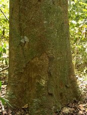 In Darién National Park, "cativo" Prioria copafiera often covers the wetland forest along the Chucunaque and Tuira rivers. (Source: Smithsonian Tropical Research Institute)
 The area has been under protection since 1972, with the establishment of Alto Darién Protection Forest (700,000 hectares (ha)) under Decree No. 84. Declared a national park on 27 September 1980 by Presidential Decree No. 21. Inscribed on the World Heritage List in 1981, and was internationally recognized as a Biosphere Reserve under UNESCO's Man and the Biosphere Programme in 1983.
Area
597,000 ha. Forms a transfrontier site with Los Katios National Park (72,000 ha).
Land Tenure
Over 90% state; 10% traditional agriculture by Chocoe and Cuna Indians.
Altitude
Sea level to 1,875 meters (m).
Physical Features
This park is in a unique geographical position, as it forms a land-bridge between the Central and South American continents. It has emerged from below sea level on several occasions, the most recent being in the early Pleistocene. The eastern part is primarily of volcanic origin covered with sedimentary rock of the Cenozoic period. The park's principal geomorphic feature is the north-east to south-east geosyncline which is surrounded by raised folds and high [[mountain]s]. The Pacific tides (from 3.8 m to 6.1 m) influence the Chucunaque and Tuira rivers for many kilometers inland. Natural erosion has resulted in numerous landslides with deep cuts and gorges.
Climate
Mean annual temperature is 26 degrees Celsius (°C) and annual rainfall ranges between 2,500 millimeters (mm) and 3,500 mm on the Atlantic side and 1,800 mm-2,500 mm in the central part of the area and on the Pacific side.
Vegetation
Contains the most extensive lowland tropical forest on the Central America Pacific coast. Darién contains a wide range of habitats: sandy beaches, rocky coasts, mangroves, freshwater marshes, palm forest swamps and lowland and upland moist tropical forest. Darién forests have been characterized by scientists as the most diverse ecosystems of tropical America and are still relatively undisturbed. The eroded landslides and associated gorges have given rise to successional plant communities, with major tracts of primary and secondary forests covering most of the terrain. The average height of the monsoon forest is approximately 40 m with occasional dominant trees reaching 50 m. The most abundant species in the area is "cuipo" Cavanillesia platanifolia. Premontane and montane forests occur above 200 m, with several types of botanically interesting ecosystems including cloud forest and the elfin forest of Cerro Pirre. Wetland forest along the Chucunaque and Tuira rivers is often covered by pure stands of "cativo" Prioria copaifera (I), this species being the most utilized timber tree in the region. Mangroves along the Pacific coast comprise Rhizophora mangle, Avicennia nitida, Laguncularia racemosa, Mora oleifera (V) and Pterocarpus officinalis.
Fauna
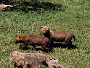 Bush Dogs (Source: Candid Specialist Grou, IUCN)
 There have been few studies of the fauna. Mammals include bush dog Speothos venaticus (V), giant anteate Myrmecophaga tridactyla (V), jaguar Panthera onca, ocelot Felis pardalis, capybara Hydrochaerus hydrochaeris, douroucoulis Aotus trivigatus, howler monkey Alouatta villosa, brown-headed spider monkey Ateles fusciceps (V), Baird's tapir Tapirus bairdii (V), agoutis Dasyprocta punctata and Aguti paca, and white-lipped peccary Tayassu pecari. Harpy eagle Harpia harpyia (R) also occurs in the park, as do Cayman crocodile Caiman crocodilus and American crocodile Crocodylus acutus (V).
Cultural Heritage
The area is both anthropologically and historically rich, with two major indigenous groups: Chocos (1,000 Emberas and Vainanas) and Kunas (200), and a number of smaller groups still living by traditional practices. The area was visited by Spanish conquistadors and the coast was explored by Christopher Columbus in 1502. In 1510, the town of Santa Maria la Antigua del Darién was established probably somewhere within the park boundaries. As a result of the Spanish presence and mistreatment, many of the Indians moved away. Today, conservation of the Indian's culture is included as a management objective. There are a number of archaeological sites.
Local Human Population
Approximately 1,000 Chocos and 200 Kunas Indians live along the edges of the rivers. These groups have maintained their subsistence agricultural systems through centuries of European contact. On the western boundary of the park, there are a number of small farming plots whose owners have no title deeds.
Visitors and Visitor Facilities
No information.
Scientific Research and Facilities
Only a few studies have been published which are concerned mainly with flora, vegetation and general ecology of the area. The area is of great scientific interest for both natural and social sciences due to the diversity of its natural ecosystems and cultural features. The Instituto Nacional de Recursos Naturales Renovables (INRENARE, National Institute for Natural Renewable Resources) has constructed administration/living-quarters in Yaviza, near the park, which have limited scientific use.
Conservation Value
The park contains the most extensive lowland tropical forest on the Pacific coast of Central America. Darien harbors a variety of habitats ranging from sandy beaches, rocky coasts, mangroves, swamps and lowland and upland tropical forests containing several endemic faunal species. In addition, two Indian tribes live in the park.
Conservation Management
The entire property is under the jurisdiction of the Republic of Panama and the following laws specifically provide protection: Decree No. 121 of May 1966, for prevention of foot and mouth disease in Darién province; Decree No. 84 of May 1972, establishing the 700,000ha Alto Darién Forest Reserve; and Decree No. 21 of August 1980, establishing the national park. During 1977-1978 INRENARE, Commission for the Control of Foot and Mouth Disease (COPFA) and the CATIE Wildlands and Watershed Project developed a detailed master plan including a zoning scheme. With the continued help of INRENARE the first stages of the plan were implemented comprising the formation of a team of full-time trained park staff; selection of key guard post sites; planning and initiation of an environmental education/public relations program; involving the indigenous populationin park planning and management; and visits to key areas to collect information on the geography, mapping, ecology, socio-economy and ethnography. There are 10 inspection guard posts patrolled by COPFA. Short-term annual operational plans are also prepared. The park is zoned as follows: strictly protected core zone of over 83,000 ha; very extended "cultural" or human activity zone of over 180,000 ha, containing Indian populations which have kept their traditional way of life and culture; a proposed development zone of some 8,000 ha for tourism and environmental education; and an inspection zone (20% outside the park) 40 km wide which runs along the Panama/Colombiaborder. Since 1986, ANCON (Asociacion Nacional para la Conservacion de la Naturaleza) has been actively involved in conservationof the park in conjunction with INRENARE, WWF and other national conservation bodies. Activities during 1986-1988 included completion of the management plan, training, equipment, signposting and provision of field equipment to the 14 Instituto Nacional de Recursos Naturales Renovables (INRENARE, National Institute for Natural Renewable Resources) rangers in the critical area adjacent to Pirre and Cruce de Mono. In 1995, a Biodiversity Conservation project was initiated. The project intends to involve local communities in conservation and sustainable use activities, and is funded by UNEP and Global Environment Facility. In addition, IUCN is supporting a project for the management of native forest in eastern Panama.
Management Constraints
Darién comprises the only uncompleted section of the Pan-American Highway. When completed, this would open up the area to settlement and greatly increase the danger of transmitting foot and mouth disease from South American cattleto Central America. Furthermore, the influx of people could lead to uncontrolled forestry, mining, agricultureand huntingresulting in deforestation, soil erosion, disruption of the fragile ecological equilibriumand dislocation of traditional indigenous practices. Some precautions and regulations for the potential impact have been implemented. The towns of El Real and Boca de Cupoe are very close to the area and the majority of their inhabitants have small farms inside the park. There are very limited areas of agriculture and disturbed forest near Chocoe and Cuna Indian villages, principally along river courses. Protection on the Colombian side of the border has been largely unsuccessful and severe forest destruction and colonist invasion are increasing. The political upheavals in 1989 have increased Instituto Nacional de Recursos Naturales Renovables (INRENARE, National Institute for Natural Renewable Resources) dependence on non-governmental organizations such as ANCON.
Staff
One superintendent, one specialist in environmental education and nine full time rangers.
Budget
Total budget for 1995 is US$665,000 comprising US$110,000 from INRENARE and US$555,000 from UNEP/GEF. A further US$265,000 were allocated for the Biological Conservation project.
IUCN Management Category
- II (National Park)
- Biosphere Reserve
- Natural World Heritage Site - Criteria ii, iii, iv
Further Reading
- Anon. (1989). Darién. Noticias de ANCON. Asociacion Nacional para la Conservacion de la Naturaleza. 2(1): 12.
- Dalfelt, A. and Morales, R., (Eds.)(1978). Plan Maestro para el establecimiento y manejo del Parque Nacional Darién, Panama. RENARE, COPFA, CATIE. 213 pp.
- Groombridge, B. (Ed.) (1993). 1994 IUCN Red List of Threatened Animals. IUCN, Gland, Switzerland and Cambridge. lvi + 228pp ISBN: 2831701945.
- IUCN/WWF Project 1648. Proposed Darién National Park.
- Morales, R. and MacFarland, C (1979). Plan Operativo para el Parque Nacional Darién, 1979-81. RENARE/CATIE. 35 pp.
- Morales, R. and MacFarland, C. eds. (1979). El Manejo conjunto de la zona fronteriza del Darién. Primera Reunion Colombo-Panamena. CATIE, Informe Téc. No. 5 1980. 52 pp.
- Worldwide Fund for Nature (1989). Protection and development of Darién National Park, Panama. WWF List of Approved Projects. October 1989. WWF, Gland, Switzerland. Pp. 485-486.
| Disclaimer: This article is taken wholly from, or contains information that was originally published by, the United Nations Environment Programme-World Conservation Monitoring Centre (UNEP-WCMC). Topic editors and authors for the Encyclopedia of Earth may have edited its content or added new information. The use of information from the United Nations Environment Programme-World Conservation Monitoring Centre (UNEP-WCMC) should not be construed as support for or endorsement by that organization for any new information added by EoE personnel, or for any editing of the original content. |