New Zealand (Countries of the world)
Contents
New Zealand
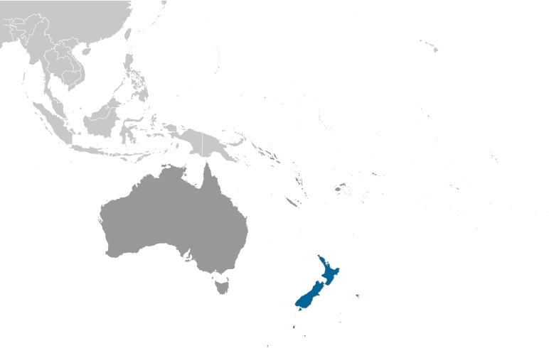
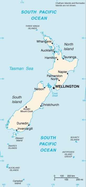
Countries and Regions of the World Collection  New Zealand is a nation of four-and-a-third million people which is composed of two major and many smaller islands in the South Pacific Ocean, southeast of Australia (across the Tasman Sea). Almost 90% of the population lives in cities. Wellington is the southernmost national capital in the world
Among New Zealand's islands are the Subantarctic Islands (Antipodes Islands, Auckland Islands, Bounty Islands, Campbell Island, and Snares Islands/Tini Heke), the Chatham Islands, and the Kermadec Islands. New Zealand also asserts a territorial claim in Antarctica (Ross Dependency).
Its major environmental issues include:
- deforestation;
- soil erosion; and,
- native flora and fauna hard-hit by invasive species
Earthquakes are common in New Zealand, though usually not severe.
New Zealand experiences significant volcanism on North Island. Ruapehu (elev. 2,797 m), which last erupted in 2007, has a history of large eruptions in the past century. Taranaki has the potential to produce dangerous avalanches and lahars. Other historically active volcanoes include Okataina, Raoul Island, Tongariro, and White Island.
Rainforest covered most of New Zealand’s land area as recently as seven thousand years ago. Isolated from the rest of the world by vast expanses of ocean, New Zealand was a haven for unique species of flora and fauna, including many species of flightless birds that evolved in safety at ground level through the millennia. Perhaps the most well-known of these flightless birds today is the Kiwi, which adapted to a forest environment, feeding mainly upon earthworms and larvae.
Geography
Location: Oceania, islands in the South Pacific Ocean, southeast of Australia
Geographic Coordinates: 41 00 S, 174 00 E
Area: 267,710 sq km. Note: includes
Coastline: 15,134 km
Maritime Claims:
Natural Hazards: earthquakes are common, though usually not severe; volcanic activity
Terrain: predominately mountainous with some large coastal plains. The highest point is Aoraki-Mount Cook (3,754 m).
Climate: temperate with sharp regional contrasts
|
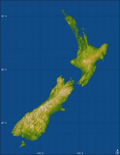
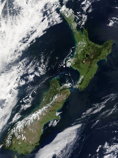
Topography of New Zealand. Source: NASA Image courtesy JPL/National Geospatial-Intelligence Agency |
This stunning true-color image provides a rare, cloud-free look at the island nation of New Zealand, including most of its North and South Islands. This scene was acquired by the Moderate Resolution Imaging Spectroradiometer (MODIS), flying aboard NASA’s Terra satellite, on October 23, 2002. New Zealand is situated in the South Pacific Ocean, roughly 2,000 km (1,250 miles) southeast of Australia. Wellington, the capital of New Zealand, is located on the southern tip of the North Island, looking across Cook Strait toward South Island. Source: NASA. Credit: Jacques Descloitres, MODIS Rapid Response Team, NASA/GSFC |
Geology
The New Zealand land mass is ancient. Geologists estimate that it separated from the ancient supercontinent of Gondwana around 80 million years ago as a single land mass, which geologists call Rangitata. Around 5 million years ago, NewZealand’s North and South Islands began to take the shape they have today.
New Zealand straddles the juncture of the Australian and Pacific tectonic plates. The Australian Plate is on the west side of the boundary, while the Pacific Plate is on the eastern side. The two plates converge in a scissor-like pattern. In the northern part of the boundary, the Australian plate overrides the Pacific plate, and in the southern part of the plate boundary, the Pacific plate overrides the Australian plate. New Zealand sits in the area around the cross point of this tectonic scissor pattern. (For help visualizing the process, take two index cards and arrange them side by side. On the left-hand card make a cut from the middle of the right edge toward the center. Lift up the top “flap” created by the cut and slide the right-hand card into the cut. Let go of the flap. The left-hand card is the Australian Plate; the right-hand card is the Pacific Plate.)
The collision of the two plates has built two major islands that together exhibit active volcanoes and fault systems, and these geologic features are very evident in the topographic pattern. The image above shows a topographic map of the North and South Islands of New Zealand made from radar data collected by the Space Shuttle Endeavor. Elevation is color-coded, with green at the lower elevations, rising through yellow and tan, to white at the highest elevations. Shading reveals the direction of slopes. Northwest slopes appear bright, and southeast slopes appear dark.
The North Island lies at the southern end of the west-over-east (Australian over Pacific) plate convergence. Here, the Pacific plate dives under the North Island, and the immense heat and pressure created by this subduction process melts the deep rock. The melted rock (magma) rises to the surface through the North Island’s volcanoes and other geothermal features. Most notable are Mount Egmont on the west coast, and Mounts Ruapehu, Ngauruhoe, and Tongariro, clustered just south of the island’s center. The Rotorua geothermal field is northeast of that cluster of volcanoes, and the field appears as a scattering of bumps created by smaller volcanic eruptions.
The South Island straddles the “cross point” of the subduction scissor pattern. To the north of the cross point, the Pacific Plate goes under the Australian Plate; to the south of the cross point, it goes over top. This area around this cross point is not in either subduction zone, which explains why it lacks the volcanic activity of the North Island.
Instead, South Island features a fault system that connects the northern subduction zone to the southern one, which occurs south of South Island. The Alpine fault is the major strand of this fault system along most of the length of the island, near and generally paralleling the west coast. Its impact upon the topography is unmistakable, forming an extremely sharp and straight northwest boundary to New Zealand’s tallest mountains, the Southern Alps. Along the Alpine Fault, the plates are sliding past each other (moving horizontally) somewhere between 35-40 millimeters per year. Vertical differences between the two plates increase at a rate of about 7 millimeters per year, which is consistent with the ongoing uplift of the Southern Alps.
Recent significant earthquakes in New Zealand include:
- February 22, 2011- Christchurch, (Magnitude 6.3)
- September 3, 2010Canterbury, (Magnitude 7.1)
- July 16, 2009Fiordland (Magnitude 7.8)
- February 5, 1995Off East Coast (Magnitude 7.0)
- August 10 and 11, 1993 North and South Islands (Magnitude 6.3 and 6.4)
- March 2, 1987Edgcumbe (Magnitude 6.3)
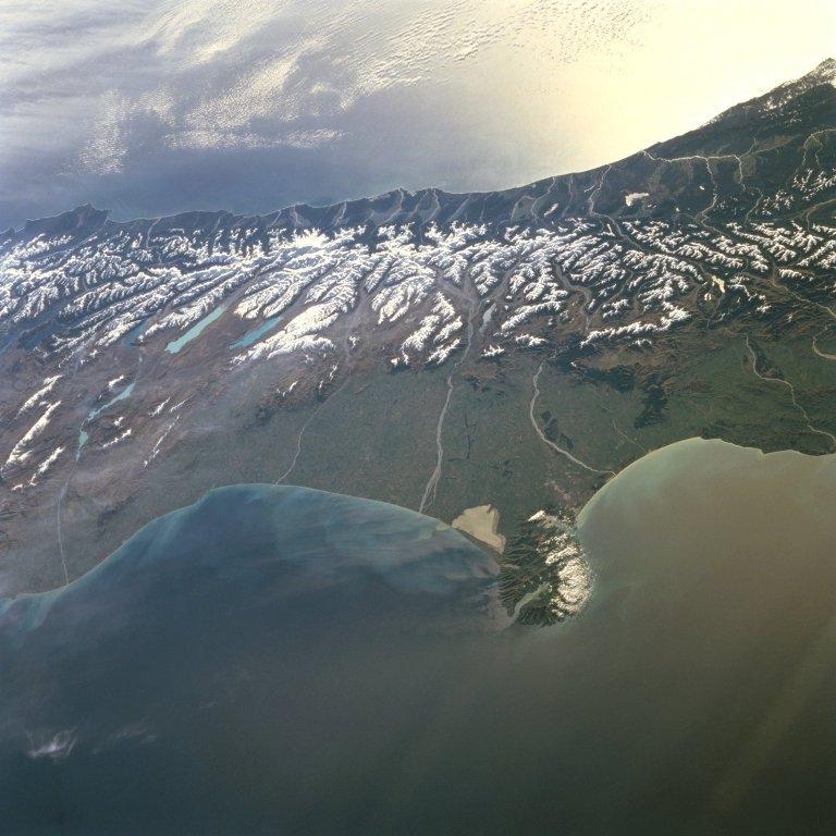
A westward-looking view of central South Island, showing the snow-covered Southern Alps fronted by the Canterbury Plain, the largest area of fertile, flat land in New Zealand. Running southwest to northeast along the western coast of South Island, the Southern Alps are rugged mountains made up of numerous peaks in excess of 3,000 m (9,840 ft). Within the Southern Alps, there are over 3,100 active glaciers. Click on photo to increase resolution. Image courtesy of NASA.
Ecology and Biodiversity
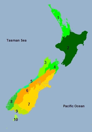
Also, the Antipodes Subantarctic Islands tundra ecorgion covers New Zealand'saSubantarctic Islands (Antipodes Islands, Auckland Islands, Bounty Islands, Campbell Island, and Snares Islands/Tini Heke) See also:
And:
|
Source World Wildlife Fund |
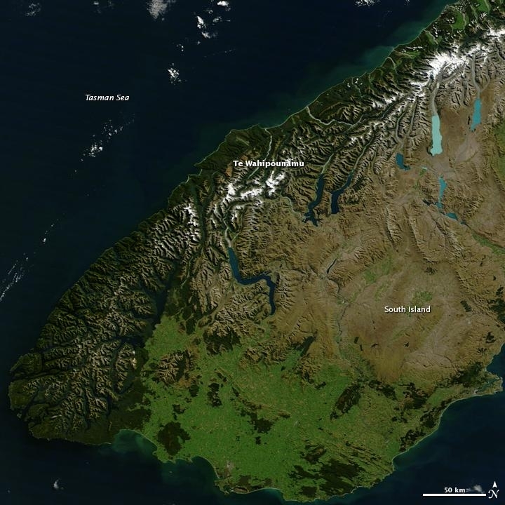
Te Wahipounamu, "the greenstone waters," is a sacred place in the Maori culture of New Zealand. The foreboding mountains and steep-walled valleys on New Zealand's southwest coast are the places of Atua, "the gods." Additionally, the streams that wash down from the glacier-capped peaks carry a highly prized stone, a hard, translucent, green rock that the Maori carved into jewelry and blades, for both tools and weapons. Most New Zealand greenstone is nephrite - a form of jade - though some is bowenite, another mineral. From space, the west coast of New Zealand resembles the greenstone for which it is named. Dark green native forest extends from the mountain tree line to the shore. The forest harbors unique and endangered animals like the kiwi and takahe, both flightless birds, and the kea, the only alpine parrot. The lighter green land in the southeast was once forested, but is now grassland or agriculture. Te Wahipounamu is wilderness, and New Zealand has set the land aside to conserve it. The entire 2.6 million ha (6.4 million acres) that make up the southwest coast of the South Island (about 10 percent of New Zealand's land area) is divided between four national parks, state forests, and other conservation areas. The natural and cultural significance of Te Wahipounamu led UNESCO to declare it a World Heritage area in 1990. Image courtesy of NASA.
People and Society
Population: 4,327,944 (July 2012 est.)
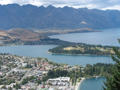
| The resort town of Queenstown on South Island is known for its adventure and ski tourism. This photo was taken from one of the hills surrounding the town, looking southeast across the harbor. Queenstown is situated at one of the turns in a Z-shaped mountain lake - Lake Wakatipu - which was formed by glacial processes. |
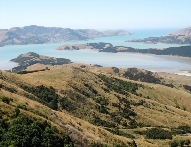
| This photo was taken looking southeast on the Banks Peninsula on South Island. The peninsula was formed from eroded remnants of two large composite shield volcanoes, the dominate craters forming the Lyttelton and Akoroa Harbors. The mountainous nature of the peninsula is atypical within the surrounding region. |
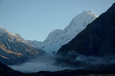
| Mount Cook (Aoraki), the tallest mountain in New Zealand, in Mount Cook National Park, South Island. |
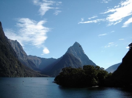
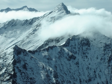
| Over the peaks in Fiordland National Park, South Island, the largest of New Zealand's national parks. |
Most of the 4 million New Zealanders are of British origin. About 15% claim descent from the indigenous Maori population, which is of Polynesian origin. Nearly 76% of the people, including a large majority of Maori, live on the North Island. In addition, 265,974 Pacific peoples live in New Zealand. During the late 1870s, natural increase permanently replaced immigration as the chief contributor to population growth and accounted for more than 75% of population growth in the 20th century. Nearly 85% of New Zealand's population lives in urban areas (with almost one-third in Auckland alone), where the service and manufacturing industries are growing rapidly. New Zealanders colloquially refer to themselves as "Kiwis," after the country's native bird.
Ethnic Groups: European 56.8%, Asian 8%, Maori 7.4%, Pacific islander 4.6%, mixed 9.7%, other 13.5% (2006 Census)
Age Structure:
0-14 years: 20.4% (male 448,106/female 426,348)
15-64 years: 66.4% (male 1,426,595/female 1,420,643)
65 years and over: 13.3% (male 260,454/female 308,201) (2011 est.)
Population Growth Rate: 0.863% (2012 est.)
Birthrate: 13.57 births/1,000 population (2012 est.)
Death Rate: 7.2 deaths/1,000 population (July 2012 est.)
Net Migration Rate: 2.26 migrant(s)/1,000 population (2012 est.)
Life Expectancy at Birth: 80.71 years
male: 78.7 years
female: 82.81 years (2012 est.)
Total Fertility Rate: 2.07 children born/woman (2012 est.)
Languages: English (official) 91.2%, Maori (official) 3.9%, Samoan 2.1%, French 1.3%, Hindi 1.1%, Yue 1.1%, Northern Chinese 1%, other 12.9%, New Zealand Sign Language (official) Note: shares sum to 114.6% due to multiple responses on census (2006 Census)
Literacy (age 15 and over can read and write): 99% (2003 est.)
Urbanization: 86% of total population (2010) growing at an annual rate of change of 0.9% (2010-15 est.)
History
Archaeological evidence indicates that New Zealand was populated by fishing and hunting people of East Polynesian ancestry perhaps 1,000 years before Europeans arrived. Known to some scholars as the Moa-hunters, they may have merged with later waves of Polynesians who, according to Maori tradition, arrived between 952 and 1150. Some of the Maori called their new homeland "Aotearoa," usually translated as "land of the long white cloud."
In 1642, Abel Tasman, a Dutch navigator, made the first recorded European sighting of New Zealand and sketched sections of the two main islands' west coasts. English Captain James Cook thoroughly explored the coastline during three South Pacific voyages beginning in 1769. In the late 18th and early 19th centuries, lumbering, seal hunting, and whaling attracted a few European settlers to New Zealand. In 1840, the United Kingdom established British sovereignty through the Treaty of Waitangi signed that year with Maori chiefs.
In the same year, selected groups from the United Kingdom began the colonization process. Expanding European settlement led to conflict with Maori, most notably in the Maori land wars of the 1860s. British and colonial forces eventually overcame determined Maori resistance. During this period, many Maori died from disease and warfare, much of it intertribal.
Constitutional government began to develop in the 1850s. In 1867, the Maori won the right to a certain number of reserved seats in parliament. During this period, the livestock industry began to expand, and the foundations of New Zealand's modern economy took shape. By the end of the 19th century, improved transportation facilities made possible a great overseas trade in wool, meat, and dairy products.
By the 1890s, parliamentary government along democratic lines was well-established, and New Zealand's social institutions assumed their present form. Women received the right to vote in national elections in 1893. The turn of the century brought sweeping social reforms that built the foundation for New Zealand's version of the welfare state.
The Maori gradually recovered from population decline and, through interaction and intermarriage with settlers and missionaries, adopted much of European culture. In recent decades, Maori have become increasingly urbanized and have become more politically active and culturally assertive.
New Zealand was declared a dominion by a royal proclamation in 1907. It achieved full internal and external autonomy by the Statute of Westminster Adoption Act in 1947, although this merely formalized a situation that had existed for many years.
Government
Government Type: Parliamentary democracy and a Commonwealth realm
New Zealand has a parliamentary system of government closely patterned on that of the United Kingdom and is a fully independent member of the Commonwealth. It has no written constitution. Executive authority is vested in a cabinet led by the prime minister, who is the leader of the political party or coalition of parties holding the majority of seats in parliament. All cabinet ministers must be members of parliament and are collectively responsible to it.
The unicameral parliament (House of Representatives) usually has 120 seats, seven of which currently are reserved for Maori elected on a separate Maori roll. However, Maori also may run for, and have been elected to, non-reserved seats. Parliaments are elected for a maximum term of 3 years, although elections can be called sooner.
The judiciary consists of the Supreme Court, Court of Appeal, High Courts, and District Courts. New Zealand law has three principal sources--English common law, certain statutes of the U.K. Parliament enacted before 1947, and statutes of the New Zealand parliament. In interpreting common law, the courts have been concerned with preserving uniformity with common law as interpreted in the United Kingdom.
Capital: Wellington - 391,000 (2009)
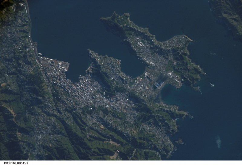
A 2007 view of New Zealand's capital of Wellington, located at the southwestern tip of North Island near the Cook Strait. The city is the second largest in New Zealand (after Auckland), and at 41 degrees south latitude, it is the southernmost capital city in the world. Five major geologic faults run through the Wellington municipality. Recognition of the potential seismic hazard in the metropolitan area has led to the adoption of building codes to maximize structural resistance to earthquake damage. Click on photo to increase resolution. Image courtesy of NASA.
Other Major Cities: Auckland - 1.36 million; (2009)
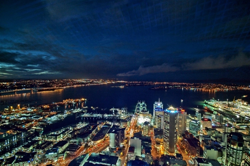
The city of Auckland, the largest in New Zealand, is home to almost a third of the country's population. This is a view of the North Island city at night as seen from its tallest tower
Administrative divisions: There are 16 regions of New Zealand, 11 of which are governed by a directly elected regional council. In the next tier there are 67 territorial authorities: 13 city councils, 53 district councils, and the Chatham Islands Council. Six territorial authorities (Auckland Council, Nelson City Council, Gisborne, Tasman, and Marlborough District Councils and the Chatham Islands Council) also perform the functions of a regional council. The Auckland Council is the largest council in Australasia. It began operating on November 1, 2010 and combines the functions of the existing regional council and the region's seven previous city and district councils into one "super council" or "super city" governed by a mayor, 20 members of the governing body, and 148 members of 21 local boards. There also are a number of community boards and special-purpose bodies with partially elected, partially appointed memberships. Local government in New Zealand has only the powers conferred upon it by parliament.
16 regions and 1 territory*; Auckland, Bay of Plenty, Canterbury, Chatham Islands*, Gisborne, Hawke's Bay, Manawatu-Wanganui, Marlborough, Nelson, Northland, Otago, Southland, Taranaki, Tasman, Waikato, Wellington, West Coast
Dependent Areas: Cook Islands, Niue, Tokelau
Independence Date: 26 September 1907 (from the UK)
Legal System: common law system, based on English model, with special legislation and land courts for the Maori.New Zealand accepts compulsory International Court of Justice (ICJ) jurisdiction; and accepts International criminal court (ICCt) jurisdiction.
International Environmental Agreements
New Zealand is party to international agreements on: Antarctic-Environmental Protocol, Antarctic-Marine Living Resources, Antarctic Treaty, Biodiversity, Climate Change, Climate Change-Kyoto Protocol, Desertification, Endangered Species, Environmental Modification, Hazardous Wastes, Law of the Sea, Marine Dumping, Ozone Layer Protection, Ship Pollution, Tropical Timber 83, Tropical Timber 94, Wetlands, and Whaling. It has signed, but not ratified international agreements om Antarctic Seals and Marine Life Conservation.
Water
Total Renewable Water Resources: 397 cu km (1995)
Freshwater Withdrawal: total: 2.11 cu km/yr (48% domestic, 9% industrial, 42% agricultural)
Per Capita Freshwater Withdrawal:
Agriculture
Agricultural products: dairy products, lamb and mutton; wheat, barley, potatoes, pulses, fruits, vegetables; wool, beef; fish
Irrigated Land: 6,190 sq km (2008)
Resources
Natural Resources: natural gas, iron ore, sand, coal, timber, hydropower, gold, limestone
Land Use:
arable land: 5.54%
permanent crops: 6.92%
other: 87.54% (2005)
Economy
New Zealand's economy historically has been based on a foundation of exports from its very efficient agricultural system. Leading agricultural exports include dairy products, meat, forest products, fruit and vegetables, fish, and wool.
The country has substantial hydroelectric power and reserves of natural gas. Based on recent natural gas exploration between Australia and New Zealand, natural gas production is projected to increase by 3.5% by 2020. Leading manufacturing sectors are food processing, wood and paper products, and metal fabrication. Service industries, particularly financial, insurance, and business services, form a significant part of New Zealand's economy. As of July 2011, the number of broadband subscribers continued to grow, and exceeded 1.5 million. The number of broadband subscribers made up 85% of all Internet subscribers.
Since 1984, government subsidies including for agriculture were eliminated; import regulations liberalized; tariffs unilaterally slashed; exchange rates freely floated; controls on interest rates, wages, and prices removed; and marginal rates of taxation reduced. Tight monetary policy and major efforts to reduce the government budget deficit brought the inflation rate down from an annual rate of more than 18% in 1987. The restructuring and sale of government-owned enterprises in the 1990s reduced government's role in the economy and permitted the retirement of some public debt. As a result, New Zealand is now one of the most open economies in the world.
After five consecutive quarters of economic retrenchment, the New Zealand economy ended its recession in the June 2009 quarter, growing by less than 0.1%. Another brief return to negative growth in September 2010 followed a first earthquake in the Canterbury region, and a sluggish recovery was further hampered by a second earthquake in February 2011. Economic growth is forecast to remain weak for the next 2 years as households go through a period of debt consolidation and government spending is further cut. New Zealand’s AA+ foreign currency rating was downgraded to AA by Standard & Poor’s in September 2011 as a result of increasing net foreign liabilities and household debt being an average 156% of disposable income. Economic activity has been increasing, with a rise in GDP of 1.8% recorded in September 2011. An export-led recovery is expected to lead to growth of around 2.7% in 2012, with partial sales of some state assets, reconstruction in Canterbury, and increased mineral exploitation. The hosting of the 2011 Rugby World Cup provided a short-term boost to the economy, but it has been difficult to quantify net benefits and long-term gains. New Zealand's unemployment rate rose to 7.3% in the last 3 months of 2009, its highest level in more than 10 years. The country’s unemployment rate as of June 2011 stood at approximately 6.5%. New Zealand's unemployment rate was lower than the Organization for Economic Cooperation and Development (OECD) average of 8.6% and was ranked 12th of 27 OECD countries with standardized unemployment rates.
New Zealand experienced a net migration loss in 2011, through the highest-ever recorded net permanent and long-term (PLT) loss to Australia of 36,900 people. This was offset by 14,200 arrivals from Australia, and net gains were experienced from most other countries, led by the United Kingdom (5,500), India (4,900), and China (4,700). In late 2011 the United States saw gains in short-term visitors from New Zealand, up 1,500 over the previous year, an increase of 55%. Short-term visitors from the United States were down 2.6% in the year to December 2011, with 184,714 visitors over that period. The largest sources of visitors over the year to December 2011 were from Australia, the United Kingdom, the United States, China, Japan, and Germany. The most popular destinations in the same year for New Zealanders were Australia, the United States, Fiji, the United Kingdom, China, the Cook Islands, and Samoa.
Traditionally, New Zealand's economy has been helped by strong economic relations with Australia. New Zealand and Australia are partners in "Closer Economic Relations" (CER), which allows for free trade in goods and most services. Since 1990, CER has created a single market of more than 22 million people, and this has provided new opportunities for New Zealand exporters. Australia is now the destination of 23% of New Zealand's exports, compared to 14% in 1983. Both sides also have agreed to consider extending CER to product standardization and taxation policy. New Zealand has had a free trade agreement with Singapore since 2001. In July 2005, both countries joined with Chile and Brunei to form a Trans-Pacific Strategic Economic Partnership (TPP), liberalizing trade in goods and services between them. On September 22, 2008, comprehensive negotiations for the U.S. to join the TPP were launched. In December 2009, President Barack Obama announced that the U.S. was interested in re-engaging on TPP. The 11th round of talks took place in March 2012.
New Zealand concluded a Closer Economic Partnership (CEP) agreement with Thailand that entered into force on July 1, 2005. In April 2008 New Zealand concluded a free trade agreement (FTA) with China. In October 2009, negotiations concluded on an FTA with the Gulf Cooperation Council (GCC--made up of Bahrain, Oman, Kuwait, Saudi Arabia, the U.A.E., and Qatar). The New Zealand/Hong Kong, China CEP was concluded in November 2009, and the agreement came into force in January 2011. In December 2007, New Zealand and South Korea announced the beginning of a study group to explore the benefits of a bilateral free trade agreement. The first round of FTA negotiations between New Zealand and South Korea took place in Seoul in June 2009. In June 2008, New Zealand and Japan established an economic working group to review their bilateral economic relationship. New Zealand and India agreed to undertake a joint study into the implications of an FTA in 2007. That study was completed in February 2009, and in January 2010 the two governments announced that negotiations would commence between their countries. Following a visit to India by Prime Minister Key in June 2011, both countries expressed a desire for an early conclusion to the deal. In August 2010 an FTA came into force between New Zealand and Malaysia. New Zealand, Russia, Belarus, and Kazakhstan began talks on an FTA in February 2011, with a second round in April 2011; they aimed to complete negotiations by the end of the year, although this did not occur.
New Zealand's top six trading partners (total trade) as of December 2011 included Australia, the People's Republic of China, the United States, Japan, the United Kingdom, and the Republic of Korea. In 2011, Australia was New Zealand's principal export market, totaling U.S. $8.94 billion, and making up 23% of New Zealand's total exports. China continued its rapid growth as New Zealand’s second-largest export market at 12.5% of total exports, up 22% from 2010 with a total of U.S. $4.87 billion. Despite having slipped to third place in 2010, the United States gained on previous years in 2011 with a 6.4% increase, totaling U.S. $3.31 billion, and making up 8.4% of New Zealand's total exports. As New Zealand's fourth-largest export destination, export trade with Japan was valued at U.S. $2.5 billion. China became New Zealand’s largest source of imports in the year ended December 2011, with a value of U.S. $6.2 billion, or 16% of total imports. Australia slipped from first place as the largest source of merchandise imports in 2011, dropping 4.1% to U.S. $6.1 billion, accounting for 15.8% of total imports. The United States is the third-largest trading partner for New Zealand, with U.S. goods and services accounting for 10.2% of all imports, totaling U.S. $3.9 billion.
The New Zealand dollar reached a 24-year high of over U.S. $0.88 in August 2011 (the highest since the New Zealand dollar was floated), and has remained high for some months, which has seen added pressure on New Zealand exports. The market-led economy offers many benefits for U.S. exporters and investors. Investment opportunities exist in chemicals, food preparation, finance, tourism, and forest products, as well as in franchising. The best sales and investment prospects are for whole aircraft and aircraft parts, medical or veterinary instruments, motor vehicles, information technology, hotel and restaurant equipment, telecommunications, tourism, franchising, food processing and packaging, and medical equipment. On the agricultural side, the best prospects are for fresh fruit, snack foods, and soybean meal.
New Zealand screens foreign investment that falls within certain criteria. Under the auspices of the Overseas Investment Act 2005, New Zealand’s Overseas Investment Office (OIO) screens foreign investments that would result in the acquisition of 25% or more ownership of, or a controlling interest in, “significant business assets” (significant business assets are defined as assets valued at more than NZ $100 million). Government approval also is required for purchases of land larger than 5 hectares (12.35 acres) and land in certain sensitive or protected areas, or fishing quotas. If the land or fishing quota to be purchased is owned by a company or other entity, approval will be required if the investor will be acquiring a 25% or more equity or controlling interest. Following a ministerial directive in December 2010, future bids to purchase sensitive or protected areas will come under even greater scrutiny to ensure that any investment is of economic benefit to New Zealand. Full remittance of profits and capital is permitted through normal banking channels.
The government plans to raise productivity growth and develop infrastructure, while reining in government spending.
GDP: (Purchasing Power Parity): $123.3 billion (2011 est.)
GDP: (Official Exchange Rate): $168.8 billion (2011 est.)
GDP- per capita (PPP): $27,900 (2011 est.)
GDP- composition by sector:
agriculture: 4.7%
industry: 24%
services: 71.3% (2011 est.)
Industries: food processing, wood and paper products, textiles, machinery, transportation equipment, banking and insurance, tourism, mining
Currency: New Zealand dollars (NZD)
