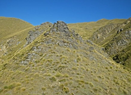
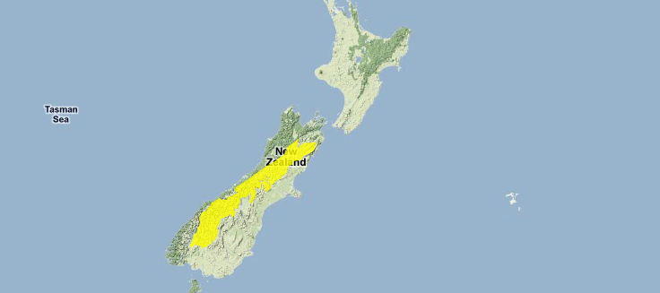
Southland montane grasslands
Encompassing the Southern Alps, Southland montane grasslands is the highest alpine region in New Zealand, with permanent snow and ice fields above the treeline, and boasting high endemism in its alpine communities. These mountains are relatively young and were formed during a dynamic period of mountain building, with high rates of uplift still occurring at the present time.
A variety of vegetation is found here, including low altitude beech forests, montane grassland, and fellfields. However, few vertebrate taxa occur in the Southland montane grasslands, with only a single native mammal and no amphibians.
Generally remote and difficult to access, the higher altitude landscape is almost completely natural and large areas are protected in a network of national parks and conservation areas. The higher altitude flora are well adapted to outcompete alien species that have partially invaded the lower elevation portions of the ecoregion.
Location and General Description
This ecoregion largely covers the high-altitude section of the Southern Alps which run for about 500 kilometers (km) along the middle of the South Island. This ecoregion also contains the high altitude valleys and passes that lead into and through the mountains, as well as the glacier-carved lakes of northwest Otago. The highest point in New Zealand is found in the Southern Alps, Mount Cook/Aoraki, which rises to 3754 metres. The Southern Alps are sparsely populated with three small alpine villages (Lewis Pass, Arthur's Pass, and Mount Cook), and a few larger resort towns around the southern lakes.
All of New Zealand's present day mountainous ranges are fairly young and only began forming around five million years ago. The highest and most spectacular of these ranges are the Southern Alps which lie directly alongside the South Island's Alpine Fault (Plate tectonics). Over the last three million years the central part of the Alps around Mount Cook has been uplifted an estimated 18,000 m, and is still ongoing. The current rate of uplift at Mount Cook/Aoraki s estimated at five millimetres (mm) per annum, with uplift near the alpine fault reaching rates of ten to twenty millimetres per year. Greywacke is the predominant rock type, so the process of erosion is also dramatic and the mountains are wearing away nearly as rapidly as they are uplifting. The mountains likely maintained the same height throughout the Pleistocene Ice Age when mountain-building was occuring at high rates, indicating natural erosion was also high.
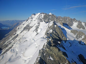 Permanent ice field, glaciation and snowpack, Continental
Divide, Southern Alps, South Island. @ C.Michael Hogan Below the treeline, Mountain Beech (Nothofagus solandri cliffortoides) is generally dominant on steep hillsides while Silver Beech (N. menziesii) and Red Beech (N. fusca) line the lower slopes and alpine valleys below about 1200 m. Closer to the principal topographic divide, more mesic species are found growing in the understory, and on the western side of the Alps there are also areas of mixed silver beech/podocarp forest and mixed rata/podocarp forest with the dominant rata being Southern Rātā (Metrosideros umbellata).
However, alpine vegetation is dominant through most of this ecoregion. The alpine and subalpine flora present along the length of the Southern Alps varies depending on soils and aspect. Where mountain beech dominates the high altitude forests, the treeline is abrupt. However, in Westland where there is a distinct absence of beech, a variety of almost impenetrable woody shrubs such as Mountain Neinei (Dracophyllum traversii) yields way gradually to tussock herbfields. The long-living, slow-growing snow tussocks (Chionochloa spp.) dominate the herbfields above the treeline. In wetter regions the Broad-leaved Snow Tussock (C. flavescens) is initially prevalent along with Mid-ribbed Snow Tussock (C. pallens) on younger, better-drained soil, while Narrow-leaved Snow Tussock (C. rigida) is more common on the eastern side of the Southern Alps. With increasing altitude the smaller Curled Snow Tussock (C. crassiuscula) takes over. A number of other large herbs grow along with tussocks, the most conspicuous being the Ranunculus buttercups (including R. lyallii, the world's largest buttercup) and various speargrasses (Aciphylla spp.).
Fellfields are found at high altitudes in the Southern Alps that are do not experience permanent snow cover. Fellfields are subject to low temperatures, heavy frosts, violent winds, and, at times, strong sunshine (Sunlight) or deep snow. Rapid erosion, frequent avalanches, and strong winds do not allow much soil to develop, especially in steeper areas. However, in sheltered spots a few small and specialized plants grow. Prostrate Hebe shrubs, small herbs with tiny flowers, diminutive grasses, and small cushion plants are most common in fellfields. There are a few larger and more striking plants including Ranunculs grahamii. This buttercup is restricted to the Mount Cook region and has been found growing as high as 2800 m. Both Hebe haastii and Parahebe birleyii have been recorded growing at up to elevation 2900 m.
In high alpine valleys, the paths of receding [[glacier]s] are easily recognized, with almost vertical mountain sides, hanging valleys, cirque landforms, and basin-like lakes and tarns. In places glaciers still extend down from the permanent ice fields into large valleys, most dramatically in the Mount Cook/Aoraki region. The Tasman Glacier extends for approximately 29 kilometres down towards Lake Pukaki. It is the longest glacier in New Zealand and among the longest in the Southern hemisphere. A chain of lakes lies along the eastern edge of the region, from Lake Coleridge in the north to Lake Wakatipu in the south, which fill glacial troughs.
Biodiversity Features
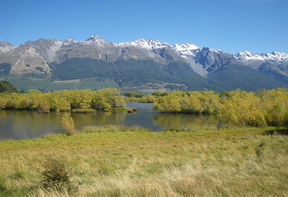 Grassy mountain lakefront, with alpine treeline beyond,
Southern Alps. @ C.Michael Hogan New Zealand's alpine flora is more diverse than the vegetation found in lowland forests. About 600 species, 25 percent of New Zealand's total, are found above the treeline nationwide, with approximately 500 species restricted to alpine zones. However, very few alpine genera are confined to New Zealand. Alpine plants likely arose in a number of ways. Some non-alpine plants were able to adapt quickly and fill new alpine and subalpine niches as the Alps themselves developed. The most successful were the woody plant genera like Hebe, Dracophyllum, and Coprosma. A small number may have developed from remnant populations of endemic cold-tolerant plants, e.g. the Snow Totara (Podocarpus nivalis). Other taxa likely reached New Zealand by long distance dispersal after the mountains had formed. Some of these genera are only represented by a few species (e.g. Anenome and Geranium), others, like the grass genus Carex, have dozens of component taxa. The fauna of this ecoregion includes a number of alpine specialists as well. However, there is a low vertebrate species richness with only 52 vertebrate species occurring here. No native amphibians occur in the ecoregion.
Birdlife
Occurring in the Southland montane grasslands are the endemic New Zealand Rock Wren (Xenicus gilviventris) and the world's only alpine parrot, the Kea (Nestor notabalis) probably evolved from lowland equivalents. The New Zealand Rock Wren remains at high elevations all year, overwintering even surviving under snow cover. In contrast, Keas often nest in the forest and feed above the treeline.
The montane beech or beech/podocarp forests that fringe most of the Alps and line the lower elevation passes through the mountains provide important habitat for two globably threatened endemic birds. The Great Spotted Kiwi (Apteryx haastii VU) is found in northern regions of this ecoregion and the South Island subspecies of the vulnerable subspecies of the New Zealand Kaka, Nestor meridionalis meridionalis, also occurs in this ecoregion.
Mammals
Only a single native mammalian taxa is found in the Southland montane grasslands ecoregion. The Vulnerable Long-tailed Wattled Bat (Chalinolobus tuberculatus), a New Zealand endemic.
Amphibians
Reptiles found in the Southland montane grasslands include: the Central Tree Gecko (Naultinus poecilochlorus), which is endemic to this ecoregion; the Eyespot Ground Skink (Oligosoma lineoocellatum), a New Zealand endemic; the Large Ground Skink (Oligosoma grande), found most commonly on schist outcrops amid tussock areas; the Spotted Sticky-toed Gecko (Hoplodactylus maculatus), a New Zealand endemic; the Lower Risk/Least Concern Natural Tree Gecko (Naultinus rudis), a New Zealand endemic; and the Near Threatened South Island Tree Gecko (Naultinus gemmeus), a South Island, New Zealand endemic.
Arthropods
This ecoregion is also notable for its rich insect biota, many with adaptations to suit the extreme conditions. Many are noticeably larger than related species or other members of their own species found at lower altitudes. For example, there are 13 species of alpine grasshoppers and size increases in a direct correlation with the elevation at which they live. Other species, such as the Bat-winged Fly (Exul singularis), have dark coloration to maximize solar heat. A number of weta (large, flightless insects restricted to New Zealand) are also found in the alpine zone, including the widespread Giant Weta (Deinacrida pluvialis) which thrives at altitudes up to 1800 m, and the Mount Cook Flea (Pharmacus montanus), a cave weta that lives in rock crevices above the snowline.
New Zealand has a scarcity of butterflies among its native insects, with only 23 butterfly taxa, plus a few specialized pollinators (Pollinator). Pollination is chiefly carried out instead by flies, moths, beetles, and short-tongued bees that are attracted primarily by white and yellow flowers. This may account for the lack of bright colors (especially reds, blues, and purples) in the alpine flowers.
History and Current Status
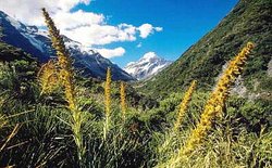 Mount Cook, Sorth Island, New Zealand. Source: WWF/Kevin Schafer Early Maori settlers were the first humans to populate this ecoregion. Their arrival approximately 1100 AD provided greatest human settlement at lower elevations to the east and west of this ecoregion, but there were parts of the Southland montane grasslands which were deforested and burned in order to pursue game herding and killing.
Most of the higher reaches of the Southern Alps remain pristine and are protected either within National Parks or conservation areas such as Lake Sumner Forest Park. These alpine and subalpine regions are probably the most thoroughly protected of any habitat type in New Zealand and fragmentation is not a major issue. Continuous areas of protection from permanent snowfields down to the valley floor are common, though there are continuous sequences all the way down to the sea only where this region joins with protected areas in the Westland temperate forests ecoregion.
Greatest intrusion of alien species is at the lower elevations, especially lake perimeters where human encroachment is most evident. In addition lower elevations have been employed for alien species conifer plantations, which destroy native habitat. Furthermore, at the lower elevations of this ecoregion there have been some incursions of non-native grasses outcompeting the native tussocks; however, the native tussocks are well adapted and difficult to displace at higher altitudes.
Types and Severity of Threats
Browsing of alpine tussocklands and subalpine forest and shrubland has been a problem in the past and is still of some concern. Government-funded control of Elk (Cervus elaphus), Chamois (Rupicapra rupicapra), and Himalayan Tahr (Hemitragus jemlahicus) began in the 1930s, continued until the 1960s for deer and chamois and remains in place for tahr in alpine areas. An increased price for venison in the 1960s and 70s meant that helicopter hunting for commercial game meat resulted in massive population reductions, especially in open or alpine areas. Browser numbers have been maintained at low levels by ongoing commercial and recreational hunting from 1983 to 1995, when there was a moratorium on commercial tahr harvest. Tahr offtake is now allowed, according to a density-dependent management plan. Hares and possums are also present in this ecoregion, but at lower densities, and these smaller browsers have not been the target of any specific meaningful control efforts.
All New Zealand's indigenous species evolved in the absence of mammalian predators and many are now flightless or poor fliers and often have a slow breeding cycle. As a consequence they are relatively easy prey for introduced and efficient predators such as stoats (Mustela erminea), cats (Felis cattus), rats (Rattus rattus and Rattus norvegicus) and other mustelids. They are particularly vulnerable in mast years when beech trees seed prolifically because mice (Mus musculus) feed on the seeds, and may reach plague proportions which in turn, benefits stoats. In a 'boom and bust' cycle, the number of mice drop and the inflated stoat population turns to native birds as an alternative food source. Mice plagues can also severely restrict forest regeneration.
Invasive weeds are not a significant problem in higher altitudes but in the lower altitude areas around the fringes of the region there are a number of problem plant species. Weeds include Big-leaf Lupine (Lupinus polyphyllus) around Mount Cook, as well as broom (Cytisus scoparius) and Douglas Fir (Pseudotsuga menziesi) around Lake Sumner and the southern lakes. Invasive weeds are especially problematic in areas that are frequently disturbed such as riverbeds or grazed tussock herbfields.
The impact of direct human exploitation is relatively small in this region except where there are areas of urban development around the southern lakes. However, human-wildlife conflicts have been a problem. Keas are intelligent, curious birds and often come down from the alpine regions to scavenge around settlements such as Arthurs Pass and commercial skifields. In the past they were accused of killing sheep on high country farms and many were killed by pastoralists. Their curiosity means that keas can cause damage to cars, campsites, and similar areas, a problem that worsens with hand-feeding and acclimation to humans.
Justification of Ecoregion Delineation
This ecoregion was carved out of ecological regions and districts as defined by the New Zealand Department of Conservation, that were naturally dominated by temperate grasslands when Europeans arrived. Natural vegetation was a mixture of grassland, heath, open woodland communities, and subalpine beech forest, and high alpine areas with little or no vegetation. The western parts of this region form part of the South Island Endemic Bird Area.
Further Reading
- J. Dawson. 1988. Forest vines to snow tussock: The story of New Zealand's plants. Victoria University Press. Wellington, New Zealand. ISBN: 0864730470
- Department of Conservation. 1987. New Zealand topographical map: Ecological regions and districts of New Zealand. Map (1:500,000). Departments of Lands and Survey, Wellington, New Zealand.
- Department of Conservation. 1993. Himalyan thar control plan. Canterbury Conservancy Conservation Management Series No 3. Christchurch, New Zealand.
- Department of Conservation. 2001. The Conservation requirements of New Zealand's nationally threatened invertebrates. Threatened species occasional publication: 20. Biodiversity Recovery Unit. Wellington, New Zealand.
- Forsyth, D., J. Parkes, and G. Hickling. 2000. A case for multi-species management of symapatric herbivore pest impacts in the central Southern Alps, New Zealand. New Zealand Journal of Ecology 24(1): 97-103.
- Hutchings, G. and C. Potton editors. 1987. Forests fiords and Glaciers, New Zealand's World Heritage. Royal Forest and Bird Protection Society of New Zealand, Wellington, New Zealand. ISBN: 0340501871
- Johns J. H. and R. J. MacGibbon. 1986. Wild animals in New Zealand (revised edition). Reed Methuen. Auckland. ISBN: 0474000257
- Mark A. F. and N. M. Adams. 1986. New Zealand alpine plants (revised edition). Reed Methuen. Auckland, New Zealand. ISBN: 0589010638
- Meads, M. 990. Forgotten fauna, the rare endangered and protected invertebrates of New Zealand. DSIR Publishing. Wellington, New Zealand. ISBN: 0477025900
- Molloy, L. 1994. Wild New Zealand. New Holland Publishers. London, United Kingdom. ISBN: 0262133040
- Soons, J. and M. Selby, editors. 1982. Landforms of New Zealand. Longman Paul, Auckland, New Zealand. ISBN: 0582717868
- Stattersfield, A. J., M. J. Crosby, A. J. Long, and D. C. Wedge. 1998. Endemic bird areas of the world. Priorities for biodiversity conservation. BirdLife Conservation Series No. 7. BirdLife International, Cambridge, United Kingdom. ISBN: 1560985747
| Disclaimer: This article contains some information that was originally published by the World Wildlife Fund. Topic editors and authors for the Encyclopedia of Earth have edited its content and added new information. Use of information from the World Wildlife Fund should not be construed as support for or endorsement by that organization for new content added by EoE personnel. |
