Richmond temperate forests
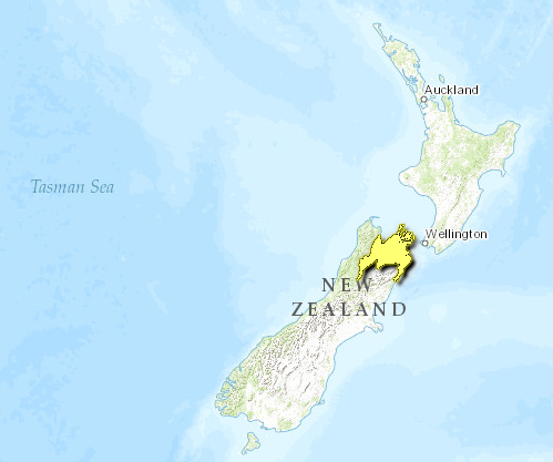
Introduction This ecoregion (Richmond temperate forests) is characterized by diverse climates, landscapes, floras, and faunas. Rugged mountain ranges in the west of the region are covered with temperate forests. To the northeast, open landscapes of tussock and rugged scree predominate. The region provides habitat for endemic and threatened flora and fauna, yet large areas with high ecological values are not fully protected.
Location and General Description
At the top of New Zealand's South Island the main Alpine Fault branches into several lesser faults creating a series of parallel ranges, diverse in character and divided by deeply incised river valleys. Inland Marlborough and the rugged Kaikoura Ranges lie to the west. These predominantly greywacke [[mountain]s] are higher than others in the region. Tapuae-o-Uenuku (2,886 meters [m]), the area's highest peak, stands about 500 m higher than the peaks in the eastern and southern ranges. Dry and cold in the winter, the western mountains are characterized by tussock land, fellfields, and large areas of open scree. Forests and wetlands that once covered the surrounding hills and lowlands have largely been removed by fires, drainage, and clearance for pasture and pines. Habitat modifications have been compounded by rapid erosion.
The Spencer Mountains lie to the south. Although their geology is similar to the Kaikoura Range, they look very different as the beech forests have mostly remained intact and this region shows signs of glaciation, including U-shaped valleys and lake-filled troughs. This area was the only portion of the Richmond temperate forests ecoregion to be glaciated to any degree during the last ice age.
To the north and east of the wide Wairau and Awatere valleys, the [[mountain]s] are less dramatic in appearance and more geologically stable. The underlying rocks are a complex mix of sandstones, siltstones, schist, and ultramafic rocks, some 280 million years old. A band of ultramafic rock, extending through the Richmond Range, creates unusually infertile soils with low levels of some minerals (e.g., potassium), and high concentrations of Magnesium, iron and nickel. These conditions make it difficult for most plants to grow here and those that do are usually stunted and sparsely distributed.
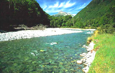
The valleys, sheltered by the surrounding hills and mountains, are often dry (average annual rainfall is between 600 millimeters [mm] and 700 mm), with hot summers and cool winters. The average maximum summer temperature is nearly 24°C, and the average minimum winter temperature is 1.6°C. The alluvial soils and river gravels were once covered in short tussocks maintained by Polynesian burning, but now support numerous orchards and vineyards. The rivers are braided, a typical feature here and on the Canterbury Plains, where there is a high loading of eroded gravels and a raised riverbed. Braided rivers are highly valued by the [[region]'s] farmers and orchardists for irrigation.
The hill country at the northern end of the Richmond and Bryant Ranges is tilted downward and the sea has flooded into the valleys to form the Marlborough Sounds and its outlying islands. While parts of the mainland and some of the islands have been much modified by land clearance, a number of the islands are free of introduced predators and/or browsers. The outer sounds are exposed to the strong winds and high seas typical of Cook Strait, but the inner sounds are more sheltered.
Where native forest forms the vegetation cover, Nothofagus beech species tend to dominate on the hills and ridges. Red beech (N. fusca) and silver beech (N. menziesii) occupy the lower, warmer, more fertile sites while hard beech (N. truncata) grows on less fertile sites at the same lower altitudes. Mountain beech (N. solandri cliffortioides), and silver beech in wetter areas, grow on steeper slopes up to the treeline. Tall conifer-broadleaf forest is confined to sheltered localities and patches along the coast. Many species reach their southern limit here, particularly those of subtropical origin like kohekohe (Dysoxylum spectabile). In the tussock herbfields above the bushline, snow tussock species like Chionochloa pallens form communities with a variety of herbs and alpine plants. In the drier, higher [[mountain]s] to the east, species of Raoulia and Haastia (Asteraceae) have developed into distinctive woolly, cushion-like forms ('vegetable sheep').
Biodiversity Features
This region encompasses a variety of climates, land forms, geologies, and soils. As a result, plant endemism and evolution are notewothy. Several localities harbor unique or unusual plant and animal communities:
The soils of the Nelson mineral belt support specialized 'serpentine' plants such as the sedge Carex uncifolia. Many are confined to such soils with some 21 species limited to the ultramafic zones in the [[mountain]s] and hills around Nelson and Marlborough (e.g., Myosotis laeta, Craspedia 'Hacket', and Geranium 'Red Hills').
The Kaikoura Ranges and South Marlborough have a very high rate of plant endemism in upland areas with 46 known endemic taxa present. The very mobile and seemingly soil-less scree slopes of the Kaikoura ranges and inland Marlborough are home to a number of specialized plants, including Ranunculus haastii, Notothlaspi rosulatum, and the endemic Marlborough scree daisy (Rachelia glaria). These plants have extensive roots systems and soft stems that help them survive in this unstable environment.
Other alpine specialists present in the tussock grasslands and fellfields include the endemic black-eyed gecko (Hoplodactylus kahutarae), New Zealand's only alpine gecko, the vulnerable scree skint (Oligosoma waimatense) and 4 species of giant weta including the Kaikoura giant weta (Deinacrida parva) and the Kaikoura Ranges weta (D. elegans) which can grow to 55 millimeters (mm). The seaward Kaikoura range is also the only mainland nesting site for the endangered Hutton's shearwater (Puffinus huttoni) which breeds among snow tussocks between 1,200 meter (m) and 1,800 m above sea level.
Twenty-five islands in the Marlborough Sounds and along the northern coast are reserved in some way and many are nationally important wildlife havens. Over a dozen species of plants and animals are now confined to these islands. Stephens Island (Takapourewa) and Maud Island, for example, are the only places where the endemic Hamilton's frog (Leiopelma hamiltoni) can be found. This primitive member of the Leiopelmatidae family does not have a tadpole stage and is one of the world's rarest frogs. Isolated on these islands, it appears to have developed into two genetically different subspecies, not yet described. Another island-isolated species has diverged so that both tuatara (Sphenadon punctatus) and Brother Islands tuatara (S. guntheri) are found here. Tuatara are the only survivors of the reptilian Order Sphenodontida; their closest relatives died out at least 60 million years ago.
The dry valleys in the rain shadow between mountain ranges contain some of New Zealand's rarest endemic plants. The coastal tree broom (Carmichaelia muritai), for example, is limited to a few [[coast]al] forest remnants while fewer than 40 specimens of the 'Chalk Range' Cheesemania are found on limestone outcrops in south Marlborough's Chalk Range.
Current Status
The continuity of protected land in this region varies considerably. The Department of Conservation manages more than 50 reserves in the Marlborough Sounds area (approximately 500 km2 total) and the main ranges to the west and south have large areas of continuous forest protected within Nelson Lakes National Park and Richmond Forest Park. However, much of inland Marlborough and the Kaikoura Ranges have been modified and remnant natural vegetation, most of which contains locally threatened and endemic species, is fragmented and poorly protected. A large amount of land is owned privately or is pastoral or Crown Lease land. Because of this, many conservation initiatives are achieved through advocacy, though legal protection is being also being actively sought for unprotected areas with high natural and historic values.
Key fauna protection programs run by the Department of Conservation in the area focus on species present on the predator-free islands, including tuatara, native frogs, kakapo (Strigops habroptilus CR), the endangered takahe (Porphyrio mantelli), and little spotted kiwi (Apteryx owenii VU). There are also a number of projects aimed at protecting the region's many threatened plants. The most comprehensive ecological management program is the Rotoiti Nature Recovery Project, a 'mainland island' launched in 1997 which aims to create a pest-free refuge in 8 km2 of beech forest beside Lake Rotoiti in the Spencer Mountains. In due course, it is hoped to reintroduce species extirpated from the area including kiwi and the yellowhead, or mohoua, (Mohoua ochrocephala).
Types and Severity of Threats
Fire is a significant threat and each year fire teams are called out to approximately 20 fires that threaten conservation reserves and fragmented remnants of natural vegetation. Other catastrophic events, such as floods and landslips, also threaten isolated or remnant communities.
Introduced predators and browsers are the main threat in already protected areas and are a potential threat on the predator-free island sanctuaries in the Marlborough Sounds. Stoats (Mustela erminea) and rats (Rattus rattus, Rattus norvegicus) prey on forest birds and bird eggs while feral pigs (Sus scrofa) and rats impact heavily on Powelliphata snail species in the Marlborough Sounds. The introduced common wasp (Vespula vulgaris), a widespread pest, has reached particularly high densities in this region because the area's beech forests host honeydew scale insects (Ultracoelostoma spp.). These insects produce a sugary exudate (honey dew) which is an important food source for a number of native birds like the kaka (Nestor meridionalis VU). However, wasps now take some 90 percent of the available honey dew in some places. In addition to competing aggressively with birds for food sources, the wasps also prey on native invertebrates.
Browsing of tussock herbfields by introduced species such as red deer (Cervus elaphus) and goats (Capra hircus) damages the fragile alpine communities because they degrade the thin soils, hasten erosion, and selectively eat palatable species. Deer are controlled to a certain extent by private hunting; goats, however, are not a preferred target and are a problem in the seaward Kaikoura Range. Australian common brushtail possums (Trichosurus vulpecula) are a significant problem nationally and cause most vegetation damage in the vulnerable [[coast]al] forest remnants.
Goats and possums are the main animal pest threats targeted in the region. Stoat and wasp control is also undertaken in selected areas (e.g., Rotoiti Nature Recovery Project area). Rodent and mustelid eradication programs are planned for some of the island reserves. Plant pest control projects target species such as box thorn (Lycium ferocissum) and old man's beard (Clematis vitalba).
Plant pest invasion is a particular problem in inland Marlborough and Kaikoura, where the natural cover has already been disturbed and on the ultramafic soils in Mt Richmond Forest Park, which only has a sparse natural cover. Problem species include Hieracium spp., briar (Rosa rubiginosa), and conifers (e.g. Pinus contorta). Weed infestation has the potential to worsen as exotic plantings increase, part of commercial efforts to control erosion. These regions often abut conservation areas, making protected areas vulnerable to invasion.
Justification of Ecoregion Delineation
The Richmond temperate forests ecoregion is centered on Wardle's 'Sounds-Nelson' botanical province, but includes portions of adjacent provinces that also contain forest, both beech forest and mixed forest along the coast. The ecoregion comprises of a number of ecological regions and districts as mapped by the New Zealand Department of Conservation. In total, the ecoregion includes the Kaikoura, Richmond, Nelson, and Inland Marlborough ecological regions in entirety, as well as the Rotoroa district from the Spenser region, and all adjacent offshore islands.
Additional information on this ecoregion
- For a shorter summary of this entry, see the WWF WildWorld profile of this ecoregion.
- To see the species that live in this ecoregion, including images and threat levels, see the WWF Wildfinder description of this ecoregion.
- World Wildlife Fund Homepage
Further Reading
- Beggs, J.R., R. J. Toft, J. P. Malham, J. S.Rees, J.A.V. Tilley, and H. Moller. 1998. The difficulty of reducing introduced wasp (Vespula vulgaris) populations for conservation gains. New Zealand Journal of Ecology, 22(1):55-63.
- Dawson, J. 1988. Forest Vines to Snow Tussock: The Story of New Zealand's Plants. Victoria University Press. Wellington. ISBN: 0864730470
- Department of Conservation. 1987. New Zealand topographical map: Ecological regions and districts of New Zealand. Map (1:500,000). Departments of Lands and Survey, Wellington, New Zealand.
- Department of Conservation. 1996. Conservation Management Strategy, Nelson/Marlborough Conservancy. Management Plan Series No. 10. Nelson/Marlborough Conservancy. Nelson.
- Department of Conservation. 1999. The conservation requirements of New Zealand's nationally threatened vascular plants. Threatened species occasional publication: 13. Biodiversity Recovery Unit. Wellington.
- New Zealand Department of Conservation. Te Papa Atawhai.
- Gill, B. and T. Whitaker. 1996. New Zealand frogs and reptiles. David Bateman. Auckland. ISBN: 1869532643
- Hilton-Taylor, C. 2000. The 2000 IUCN Red List of Threatened Species. IUCN, Gland, Switzerland and Cambridge, United Kingdom. ISBN: 2831705657
- Mark A F. and N. M. Adams. 1986. New Zealand's Alpine Plants (revised edition). Reed Methuen, Auckland. ISBN: 0589010638
- McKinnon, M. editor. 1997. New Zealand Historical Atlas, Ko Papatuanuku e Takoto Nei. David Bateman, Auckland. ISBN: 1869533356
- Molloy, L. 1988. Soils in the New Zealand Landscape: The Living Mantle. Mallinson Rendel. Wellington. ISBN: 0908606559
- Molloy, L. 1994. Wild New Zealand. New Holland Publishers. London. ISBN: 0262133040
- Robertson, C. J. R. editor. 1991. The Reader's Digest Complete Book of New Zealand Birds. Reader's Digest. Sydney. ISBN: 094981962X
- Wardle, P. 1991. Vegetation of New Zealand. Cambridge University Press, Cambridge, United Kingdom. ISBN: 0521258731
| Disclaimer: This article is taken wholly from, or contains information that was originally published by, the World Wildlife Fund. Topic editors and authors for the Encyclopedia of Earth may have edited its content or added new information. The use of information from the World Wildlife Fund should not be construed as support for or endorsement by that organization for any new information added by EoE personnel, or for any editing of the original content. |


