Cook Islands
| Topics: |
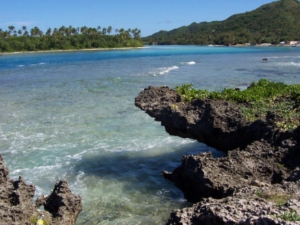
Beach on Rarotonga. Source: Wikipedia
Countries and Regions of the World Collection  The Cook Islands are composed two groups of islands in the South Pacific Ocean, about half way between Hawaii and New Zealand, about 1,000 km east of Niue.
They have a population of just over 11,000.

|
|

The northern Cook Islands are seven low-lying, sparsely populated, coral atolls.
- Manihiki (Te Fuinga o Niva)
- Nassau (Te Nuku o Ngalewu )
- Penrhyn Island (Tongareva or Mangarongaro)
- Pukapuka (Te Ulu o te Watu)
- Rakahanga (Tapuahua)
- Suwarrow also called Suvorov
- Tema Reef (submerged)
The southern Cook Islands, where most of the population lives, consist of eight elevated, fertile, volcanic isles, including the largest, Rarotonga, at 67 sq km; plus one submerges reef. The southern Cook Islands extend 450 km from north to south, and encompass a diversity of terrain ranging from the ancient, steep volcanic cone of Rarotonga to the "almost-atoll" of Aitutake. Although little native vegetation remains in the accessible lowland zones, significant areas of fairly intact montane rain and cloud forest can still be found on the upper slopes of Rarotonga. These forests are some of the best remaining examples of primary montane rain and cloud forest in Eastern Polynesia.
- Nga-pu-Toru ("Three Roots", the eastern islands):
- Atiu (Enua Manu or Island of Birds)
- Ma'uke (Akatokamanava)
- Mitiaro (Nukuroa)
- Takutea
- other islands:
- Aitutaki (Araura Enua)
- Mangaia (Auau Enua)
- Rarotonga (Tumutevarovaro), with the capital, Avarua.
- Palmerston Island (Pamati) sometimes grouped with the Northern Group.
- Manuae
- Winslow Reef (submerged)
Rarotonga, the largest and highest of the islands, is a deeply eroded, long-extinct volcanic cone with steep sides. Four of the other principal islands—Miti’aro, Atiu, Ma’uke, and Mangaia—are the remains of ancient volcanoes. After undergoing subsidence and submergence, they were uplifted during the Tertiary to heights of approximately 100 meters (m) above sea level. They have central volcanic hills surrounded by makatea: broad uplifted ancient coral reefs, as much as 2 km wide. Palmerston and Manuae are atolls, while Takutea is a small table reef. Aitutake is an "almost-atoll"—a central volcanic island surrounded by a barrier reef.
The cook Islands are susceptible to typhoons (November to March).
Named after Captain James Cook, who sighted them in 1770, the islands became a British protectorate in 1888.
By 1900, administrative control was transferred to New Zealand; in 1965, residents chose self-government in free association with New Zealand. Cook Islands is fully responsible for internal affairs; New Zealand retains responsibility for external affairs and defense in consultation with the Cook Islands.
The emigration of skilled workers to New Zealand and government deficits are continuing problems.
Contents
Geography
Location: Oceania, group of islands in the South Pacific Ocean, about half way between Hawaii and New Zealand
Geographic Coordinates: 21 14 S, 159 46 W
Area: 236 sq km
Coastline: 120 km
Maritime Claims:
Natural Hazards:
Terrain: low coral atolls in north; volcanic, hilly islands in south. The highest point is Te Manga (652 m)
Climate: tropical oceanic; moderated by trade winds; a dry season from April to November and a more humid season from December to March
Agricultural products: copra, citrus, pineapples, tomatoes, beans, pawpaws, bananas, yams, taro, coffee; pigs, poultry
Land Use:
other: 75% (2005)


Ecology and Biodiversity
See: Cook Islands tropical moist forests
The lowland forests have been converted through human use. The forests on the upper slopes of Rarotonga may be representative of the original montane forests of the Cook Islands. Merlin divided these forests into three principal forest types. The first two are classified as montane rain forest, and the third as cloud forest.
- Homalium forest is found on the inland mountain slopes above an irregular contour line that ranges from 50 to 200 meters. This closed canopy forest is dominated by Homalium acuminatum, with other common species including Canthium barbatum, Elaeocarpus tonganus, and Ixora bracteata. A giant liana Entada phaseoloides is also prominent.
- Fagraea-Fitchia forest occurs on knife-edge ridges at mid-elevations. The dominant trees, Fagraea berteroana and Fitchia speciosa, both have massive and extensive root systems which help stabilize the ridges by holding the broken rocks together. Other common tree genera here include Homalium, Canthium, Alyxia, Coprosma, Meryta, and Metrosideros.
- On the cloud-covered peaks and ridges above 400 m elevation is the Metrosideros cloud forest, which comprises about 3 percent of the total inland forest. A low-stature (8 m or less) krumholz form of Metrosideros collina is the dominant tree in this forest, but in higher and wetter places it may share dominance with, or be replaced by, Ascarina diffusa. Also common is Elaeocarpus tonganus (the only Elaeocarpus species found on Rarotonga, though there are about 200 species throughout the Pacific), Weinmannia samoensis, and Pittosporum arborescens. An indigenous woody liana, Freycinetia arborea, is also commonly seen, as well as numerous epiphytic mosses and ferns. The understory is dominated by an endemic woody shrub, Fitchia speciosa, whose genus is restricted to French Polynesia and Rarotonga. Nine species of flowering plants are found only in tropical moist cloud forest of Rarotonga.
The makatea islands have similar flora to Rarotonga, with differences related to their structurally variability (volcanic vs. makatea (limestone) substrates). Vegetation in the volcanic inner hills of the makatea islands has been almost completely introduced, with the area mostly given over to cultivation. In the makatea zones, however, most species are indigenous, and have been preserved because of the rough, almost inaccessible terrain. Makatea forest zones include a mixed-species forest dominated by Elaeocarpus tonganus and Hernandia moerenhoutiana, a Pandanus tectorius scrub forest, and a Barringtonia asiatica forest.
Palmerston Atoll, and other small atolls in the Southern Cooks, are covered with typical atoll vegetation (Heliotropum anomalum on the beach and inland, Scaevola, Suriana, and Pemphis behind the beach, and forest patches of Pisonia, Guettarda, and Pandanus, or planted coconuts (Cocos nucifera) inland.
Biodiversity Features
Of the 538 known angiosperm species in the southern Cook Islands, approximately 4 percent are endemic; however, there are no endemic genera. About 130 plant species are native. It is thought that about 12 percent of the current flora was probably introduced by the early Polynesians, and another 60 percent brought in after European contact. There are also ten native terrestrial reptiles, none of which are endemic. Thirteen endemic species of endodontid snails and 11 species of charopid snails were found, but most are now extinct, and others are threatened, especially on Rarotonga.
The herpetofauna of the Cook Islands, as well as that of the Societies, Tuamotus, and Marquesas consists mainly of species found throughout the tropical Pacific, and generally includes species transported by humans. Only one species, Emoia trossula, is restricted in its range (Cooks, Fiji, Tonga) within Central Polynesia.
There are eight species of range-restricted birds in the Southern Cook Islands (which includes Aitutaki), six of which are strictly endemic. A reed-warbler (Acrocephalus kerearako), fruit dove (Ptilonopus rarotongensis), and kingfisher (Todiramphus ruficollaris) are shared between at least two islands. The fruit dove and kingfisher are considered Vulnerable. Of the three single island endemics, the Atiu swiftlet (Collocalia sawtelli), Rarotonga starling (Aplonis cinerascens), and Mangaia kingfisher (Todiramphus ruficollis) are considered Vulnerable. The Vulnerable restricted-range blue lorikeet (Vini peruviana) is found on Aitutaki, and the island is delineated as a Secondary Endemic Bird Area for that reason, but it is unclear whether the species is actually native to the island. Once considered one of the rarest birds in the world and believed to be extinct in 1900, only 21 birds and two nests of the Rarotonga monarch (Pomarea dimidiata) were found 1983. In 1987, 35 birds were found in southeastern Rarotonga in mid-elevation montane forest. An intensive conservation program was begun in 1987, which included predator control (Rattus rattus), has improved this bird's situation to Endangered. The bird’s habitat has been given protection as the Takitumu Conservation Area, which is now being managed for ecotourism.
The mountains of central Rarotonga, in the area of the proposed Te Manga Roa Reserve, are also one of the few known breeding grounds of the herald petrel (Peterodroma arminjoniana). Considered extinct in 1899, it is now relatively common in this part of Rarotonga. Also of conservation interest is the mist landsnail (Tekoulina sp.). This gastropod is unique because it is viviparous (bears live young), and is endemic to the proposed reserve.
The Pacific flying fox (Pteropus tonganus) is the most common flying-fox in Fiji, Samoa, Tonga, and the Cook Islands – it is among the most widespread of the flying foxes. The Cooks represent the easternmost range of Pteropus spp. in the Pacific. The bat is the only native mammal in the Cook Islands.
Current Status
The Cook Islands have long been settled by Polynesians. At low elevations, little native vegetation remains, and the lowlands are dominated by coconut palms. However, on the upper slopes of Rarotonga there remains relatively undisturbed montane rain forest and, higher still, cloud forest. The forests of Rarotonga’s upper slopes are some of the best remaining examples of primary montane rain and cloud forest in Eastern Polynesia.
In 1969, official protection status was proposed for a 0.118 km2 reserve in the central mountains of Rarotonga (Te Manga Nature Reserve), but it had not been ratified as of 1993. The reserve would include 80 percent of the island’s cloud forest above 400 meters (m), and would serve as a good illustration of Eastern Polynesian montane rain and cloud forest, that provides habitat for many endemic species.
Types and Severity of Threats
Rats and other introduced animal species such as the common myna (Acridotheres tristis), which was brought in to control insects in the early twentieth century, may be interfering with the nesting of the endemic Mangaia kingfisher (Todirhamphus ruficollaris). Cats and rodents are also potentially dangerous predators. Between 1870 and 1965, the African ant (Pheidole megacephala) caused extinction of 11 of the 13 endemic snail species on Rarotonga.
Government
Government Type: self-governing parliamentary democracy
Capital: Avarua
Independence Date: none (became self-governing in free association with New Zealand on 4 August 1965 and has the right at any time to move to full independence by unilateral action)
Legal System: common law similar to New Zealand common law. The cook Islands has not submitted an International court of justice (ICJ) jurisdiction declaration (New Zealand normally retains responsibility for external affairs); but accepts International Criminal court (ICCt) jurisdiction.
People and Society
Population: 10,777 (July 2012 est.) - The 2001 census counted a resident population of 15,017
Ethnic groups; Cook Island Maori (Polynesian) 87.7%, part Cook Island Maori 5.8%, other 6.5% (2001 census)
Age Structure:
0-14 years: 25.1% (male 1,479/female 1,308)
15-64 years: 65% (male 3,737/female 3,499)
65 years and over: 9.9% (male 538/female 563) (2011 est.)
Population Growth Rate: -3.136% (2012 est.)
Birthrate: 15.22 births/1,000 population (2012 est.)
Death Rate: 7.61 deaths/1,000 population NA (July 2012 est.)
Life Expectancy at Birth: 74.92 years
male: 72.13 years
female: 77.86 years (2012 est.)
Total Fertility Rate: 2.35 children born/woman (2012 est.)
Languages: English (official), Maori
Literacy: (age 15 and over can read and write): 95%
Urbanization: 75% of total population (2008) growing at an annual rate of change of 1.4% (2010-15 est.)
|
|
|
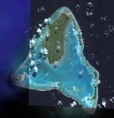
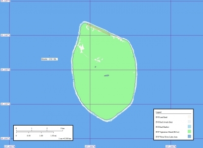
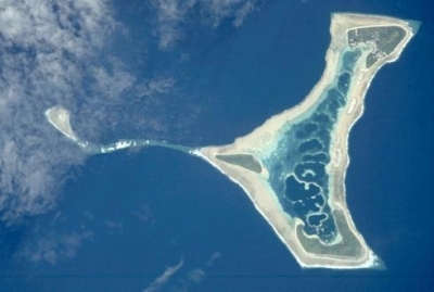
| Aitutaki (including uninhabited Manuae) | |
|
|
|
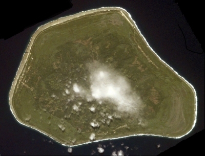
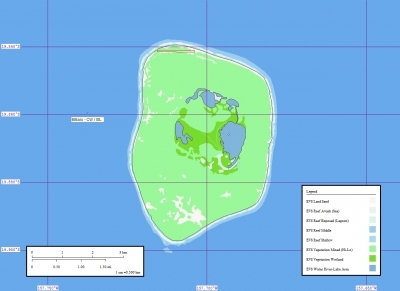
| Mangaia | |
|
|
|
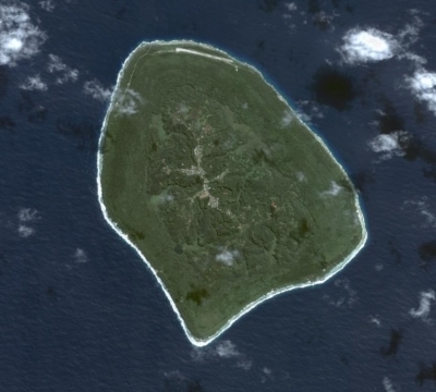
| Atiu (including uninhabited Takutea) | |
|
|
|
| Ma'uke | |
|
|
|
| Mitiaro | |
|
|
|
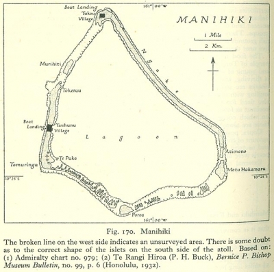
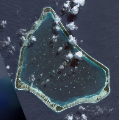
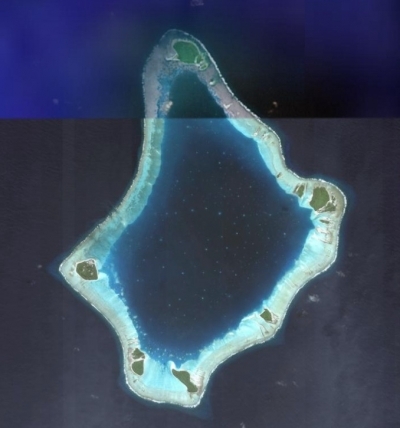
| Manihiki | |
|
|
|
| Penrhyn | |
|
|
|
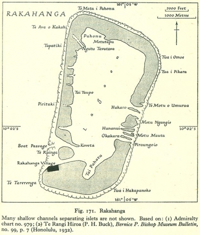
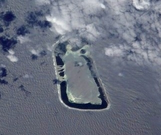
| Rakahanga | |
|
|
|
| Pukapuka (including Nassau and Suwarrow) | |
|
|
|
| Palmerston | |
| Cook Islands. Maps Sources: Wikipedia. Images Source: NASA | |


Economy
Like many other South Pacific island nations, the Cook Islands' economic development is hindered by the isolation of the country from foreign markets, the limited size of domestic markets, lack of natural resources, periodic devastation from natural disasters, and inadequate infrastructure.
Agriculture, employing more than one-quarter of the working population, provides the economic base with major exports made up of copra and citrus fruit.
Black pearls are the Cook Islands' leading export.
Manufacturing activities are limited to fruit processing, clothing, and handicrafts.
Trade deficits are offset by remittances from emigrants and by foreign aid overwhelmingly from New Zealand. In the 1980s and 1990s, the country lived beyond its means, maintaining a bloated public service and accumulating a large foreign debt. Subsequent reforms, including the sale of state assets, the strengthening of economic management, the encouragement of tourism, and a debt restructuring agreement, have rekindled investment and growth.
GDP: (Purchasing Power Parity): $183.2 million (2005 est.)
GDP: (Official Exchange Rate): $183.2 million (2005 est.)
GDP- per capita (PPP): $9,100 (2005 est.)
GDP- composition by sector:
Industries: fruit processing, tourism, fishing, clothing, handicrafts
Currency: NZ dollars (NZD)
Further Reading
- Allison, A. 1996. Zoogeography of amphibians and reptiles of New Guinea and the Pacific region. Pages 407-436 in Keast, A. and S.E. Miller, editors. The origin and evolution of Pacific island biotas, New Guinea to Eastern Polynesia: Patterns and processes. SPB Academic Publishing, Amsterdam. ISBN: 905103136X
- Birdlife International. 2000. Threatened birds of the world. Lync Edicions and Birdlife International, Barcelona & Cambridge, UK. ISBN: 0946888396
- Dahl, A.L. 1986. Review of the protected areas system in Oceania. International Union for Conservation of Nature and Natural Resources, Commission on National Parks and Protected Areas, in collaboration with the United Nations Environment Programme. ISBN: 2880325099
- Fitter, R. 1986. Wildlife For Man: How and Why We Should Conserve Our Species. Collins, London, United Kingdom for IUCN Species Survival Commission, Gland, Switzerland. ISBN: 0002194422
- Flannery, T.F. 1995. Mammals of the southwest Pacific islands. Reed, Chatswood. ISBN: 0801431506
- Fosberg, F.R. 1998. Chapter 8: Eastern Polynesia. Pages 385-460 in D. Mueller-Dombois and F.R. Fosberg, editors. Vegetation of the Tropical Pacific Islands. Springer-Verlag New York, Inc. ISBN: 0387983139
- Hilton-Taylor, C. (compiler) 2000. 2000 IUCN Red List of Threatened Species. IUCN, Gland, Switzerland. ISBN: 2831705657
- IUCN. 1991. Directory of protected areas in Oceania. International Union for Conservation of Nature and Natural Resources. ISBN: 2831700698
- Merlin, M. and J. Juvik. 1993. Montane cloud forest in the tropical Pacific: Some aspects of their floristics, biogeography, ecology, and conservation. In Tropical Montane Cloud Forests: Proceedings of an International Symposium. L.S. Hamilton, J.O. Juvik, and F.N. Scatena, editors. East-West Center, Honolulu, Hawaii.
- Merlin, M. 1985. Woody vegetation in the upland region of Rarotonga, Cook Islands. Pac. Sci. 39:81-99.
- Merlin, M. 1991. Woody vegetation on the raised limestone of Mangaia, southern Cook Islands. Pac. Sci. 45:131-151.
- Mueller-Dombois, D. and F.R. Fosberg. 1998. Vegetation of the tropical Pacific islands. Springer-Verlag, New York. ISBN: 0387983139
- Pearsall, S. 1990. South Pacific Data (computer file). The Nature Conservancy, Honolulu, HI.
- Stattersfield, A.J., M.J. Crosby, A.J. Long, and D.C. Wege. 1998. Endemic bird areas of the world: priorities for biodiversity conservation. BirdLife Conservation Series No. 7. BirdLife International. Cambridge, UK. ISBN: 1560985747