Modeling of sea ice processes
Modeling and its importance
Information about sea ice processes can come from field camps or aircraft and satellites. However, data from these sources are limited. Sensors cannot account for all characteristics of sea ice anytime and anywhere. Furthermore, the record of sea ice data has a limited history. Satellite observations date back only to the mid-1970s; other observations, such as ship records, may go back as far as the late 19th Century, but they are sparse. Moreover, these data cannot predict the future of sea ice extent.
To fill in the gaps in knowledge about sea ice, scientists use models to simulate sea ice processes. A model is a mathematical representation of a real-world physical process. These models allow scientists to reconstruct historical patterns of sea ice and predict future changes. Due to the complex nature of the models, they are run on computers.
Sea ice models have a more specific focus than General Circulation Models (GCMs), which simulate the climate of the entire world. You may have read about GCMs in the newspaper or a science magazine. They are often used to investigate the effects of global warming caused by increasing carbon dioxide, including the studies used for the Intergovernmental Panel on Climate Change (IPCC). Until recently, sea ice has been included in a rudimentary manner in GCMs. Because GCMs have shown that the the polar regions are particularly sensitive to small changes in climate, newer GCMs have improved sea ice models considerably.
Sea ice modeling
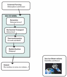
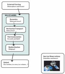
 The flowchart illustrates a typical sea ice modeling scenario that takes into account processes such as internal stress, advection (horizontally blowing winds), thermodynamics, and ridging. (Source: NSIDC)
 Sea ice models provide valuable information on how sea ice evolves and how it will be affected by changing climate.
Numerical sea ice models are primarily used to study the important processes involved in the evolution of sea ice and are used for long-term climate studies. However, models are also used to provide short-term operational forecasts (one to five days) for ocean vessels in sea ice-covered regions, as well as seasonal forecasts (one to three months) to aid in planning. The U.S. Navy, for example, runs an operational sea ice model, the Polar Ice Prediction System (PIPS), to provide short-term forecasts of Arctic sea ice.
The equations in a sea ice model describe the relevant dynamics and thermodynamics that influence the evolution of sea ice. The dynamics equations take into account winds, currents, and other forces that influence sea ice motion. The thermodynamics equations take into account air and ocean temperatures, albedo, and other forces that influence the growth and melt of sea ice.
The evolution of sea ice is influenced by the ocean below and the atmosphere above. These influences are represented in models as boundary conditions, or conditions outside of the model, at the top and bottom of the sea ice. Boundary conditions are more specifically referred to as forcings, because they force the sea ice to change in a certain way, based on influences from the ocean and atmosphere. An example is that air temperatures above freezing cause the sea ice to melt, whereas air temperatures below freezing cause the sea ice to grow.
The processes involved in sea ice evolution are too complex to be exactly described by mathematical equations within models. These equations are approximations that capture only the processes necessary for the model application. Models carry assumptions, and predictions from the models have inherent uncertainties. In theory, a more complex model provides a more realistic simulation. However, the accuracy of the model is limited internally by the model physics, and externally by the boundary conditions, or forcing. As computers become more powerful and sea ice models are improved, simulations from models will have fewer uncertainties.
Sea ice models are often combined with ocean or atmospheric models. These are called coupled models, because rather than specifying the ocean or atmosphere as forcings, the sea ice, ocean, or atmosphere interact with each other and all the components evolve together. Coupled models can include sea ice and ocean, sea ice and atmosphere, or all three.
How sea ice models work
Numerical models represent sea ice in cells. A cell is the smallest discrete area that can be described by the model. Within each cell, there is no variability in space of any of the properties. This property of model cells is similar to an image captured by a digital camera, where each image pixel is only one color. Each cell has a finite area, for example, 10 square kilometers (3.9 square miles) and describes several dynamic and thermodynamic properties, such as thickness, temperature, and velocity. The entire group of cells is referred to as a domain. As the number of grid cells increases in a model domain, so does the spatial resolution. Having a large number of grid cells describes sea ice conditions on smaller scales—tens of kilometers, versus hundreds). However, the cost of storing and computing the model increases substantially.
The properties of each grid cell change as the model is run forward in time, based on the model equations and boundary conditions.
After a model is run, the output is essentially a set of relevant sea ice variables, such as concentration, extent, and thickness, over time at each grid cell. Model outputs can be evaluated using sea ice observations (such as satellites and buoys) to determine how accurate the model is.
| Disclaimer: This article is taken wholly from, or contains information that was originally published by, the National Snow and Ice Data Center. Topic editors and authors for the Encyclopedia of Earth may have edited its content or added new information. The use of information from the National Snow and Ice Data Center should not be construed as support for or endorsement by that organization for any new information added by EoE personnel, or for any editing of the original content. |
