Geoindicators (Climate Change)
Contents
- 1 Geoindicators
- 1.1 Introduction Figure 1. This ravine in northern Argentina was not long ago a farm road similar to the present one. (Credit: A. R. Berger (Geoindicators) )
- 1.2 Rapid Geological Change
- 1.3 What are Geoindicators?
- 1.4 Applying Geoindicators
- 1.5 Causes of Rapid Geological Change
- 1.6 Geoindicators and Ecosystems
- 1.7 Rapid Landscape Change: Drivers and Responses
- 1.8 TablesTABLE 1. Geoindicators and (in brackets) some associated environmental changes, in addition to climate and weather patterns. CryosphereFrozen ground activity - freezing and thawing of surface materials, melting of permafrost, and ground heaving and subsidence (surface and groundwater circulation, land surface degradation)Glacier fluctuations - advancing or retreating ice sheets and valley glaciers (surface albedo, river runoff, sea-level) Arid & Semi-Arid Zones Desert surface crusts & fissures - development of cracks and biological crusts (biological productivity)Dust storm magnitude, duration, & frequency - movement of wind-blown dust (atmospheric transport of particulates, land use)Dune formation & reactivation - movement and stabilization of sand (wind speed and direction, moisture, sediment availability)Wind erosion - abrasion of rocks and soils by wind-blown particles (land use, vegetation cover) Marine & Coastal Zones Coral chemistry & growth patterns - annual growth layers preserving traces of surrounding environmental conditions (surface water temperature, coastal pollution, salinity)Relative sea level - rise or fall of sea level in one coastal area relative to another (coastal subsidence and uplift, fluid withdrawal, sedimentation and compaction)Shoreline position - movement of shoreline through erosion or accretion, regional subsidence or sea level change (coastal erosion, land use, sea level, sediment transport and deposition) Lakes Lake levels and salinity - rise or fall of lakes and changes in water chemistry (land use, streamflow, groundwater circulation)Wetlands Wetland extent, structure & hydrology - expansion or reduction of swamps, bogs, mangroves and other wetlands, variations in water content (land use, biological productivity, streamflow)Rivers & Streams Streamflow - changes in volume of flowing water, including flooding and drying out (basin discharge, land use)Stream channel morphology - shape and position of active streams (sediment load, flow rates, land use, surface displacement)Stream sediment storage & load - movement and deposition of sand, silt and gravel by rivers (flow rates, land use, basin discharge)Surface & GroundwaterKarst activity - underground dissolution of easily soluble rocks (groundwater chemistry and flow, vegetation cover, stream processes)Surface water quality - changes in the chemistry of lakes, rivers and streams (land use, water-rock-soil interactions, flow rates)Groundwater quality - changes in the chemistry of underground water (land use, pollution, rock and soil weathering, acid precipitation, radioactivity)Groundwater chemistry in the unsaturated zone - changes in chemistry of water in soils (weathering, land use)Groundwater level - variations in the level of water in wells, springs and aquifers (withdrawal of water, recharge)SoilsSoil quality - changes in the texture and chemistry of soil (land use; chemical, biological and physical soil processes)Soil & sediment erosion - removal of soil and soft rock material (surface runoff, wind, land use)Natural Hazards Seismicity - natural and human-induced release of earth stresses (reservoir construction) Landslides & avalanches - downhill movement of rock, surface debris and snow avalanches (slope stability, earthquakes, land use)Volcanic unrest - changes in eruptive activity in and around volcanoes (near-surface movement, degassing of molten rock, sub-surface heat flow)Other Sediment sequence & composition - changes in the layers of sediment deposited at the surface (land use, erosion and depositioSurface displacement - ground uplift and subsidence (faulting, fluid extraction)Subsurface temperature regime - near surface changes in the pattern of the earth’s internal heat flow ( heat flow, vegetation cover, land use) Table 2. Relative importance of human vs non-human drivers of rapid geological changeS = Strongly influenced by; P = potentially influenced by; N = no substantial influence on. Geoindicator Natural Human Coral chemistry and growth patterns S S Desert surface crusts and fissures S P Dune formation and reactivation S P Dust storm magnitude, duration, frequency S P Frozen ground activity S P Glacier fluctuations S N Groundwater quality P S Groundwater chemistry unsaturated zone S S Groundwater level P S Karst activity S P Lake levels and salinity S S Relative sea level S P Sediment sequence and composition S S Seismicity S P Shoreline position S S Slope failure (landslides) S S Soil and sediment erosion S S Soil quality P S Streamflow S S Stream channel morphology S S Stream sediment storage and load S S Subsurface temperature regime S P Surface displacement S P Surface water quality S S Volcanic unrest S N Wetlands extent, structure, and hydrology S S Wind erosion S P (Geoindicators)
- 1.9 Note
- 1.10 Further Reading
Geoindicators
| Topics: |
Geology (main)
|
Introduction Figure 1. This ravine in northern Argentina was not long ago a farm road similar to the present one. (Credit: A. R. Berger (Geoindicators) )
Geoindicators provide a convenient summary of the non-human physical and chemical processes that can change landscapes and ecosystems in less than 100 years. Such changes have long provided the natural background for planetary and organic evolution, but now they can also be influenced by human activities. The geoindicator approach brings together in one format the important measures of rapid geological change that are useful for assessing the condition of landscapes, natural areas, and environments in general. Among the key non-biological components that need to be tracked are the condition of groundwater resources, patterns of erosion and deposition, especially along rivers and coastlines, the physical condition of soils, and the stability of slopes that could lead to significant landslides and avalanches. Recognizing the direction and magnitude of rapid landscape changes is essential to attaining a future that is more sustainable.
Rapid Geological Change
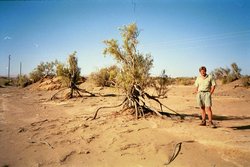 Figure 2. Deflation by wind erosion of scrub trees in southern Namibia. (Credit: A. R. Berger)
 Geological processes have operated since the early days of the Earth, and have set the scene for the development of life itself. The ultimate driving forces have been either external to the lithosphere and primarily climatic, or internal, as in heat flow and energy fluxes from beneath the Earth’s surface. However, since life itself began there have been interactions between organisms and soils, rocks, water and air. Humans have now become geological agents, far more potent and quick-acting than any other species in the past. The pace of geological and ecological change has increased dramatically in modern times, at least in comparison to the past 10,000 years of the Holocene time period.
There are innumerable examples of geological change that take place in minutes (landslides, earthquakes), days (floods, dust storms), weeks (eruptions), or a year or two (glacier flow, coastal and soil erosion, movement of sand dunes). Many of these can alter and transform landscapes (Landform development) and can profoundly affect settlements and ecosystems.
What are Geoindicators?
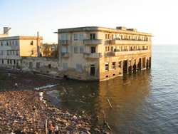 Figure 3. Hotel on the shore of lake Mar Chiquita, Argentina, abandoned when water levels rose during period of high rainfall. (Credit: A. R. Berger)
 Geoindicators are environmental indicators that deal mainly with natural landscape change. They are defined as magnitudes, frequencies, rates or trends of geological processes and phenomena that occur at or near the Earth's surface and that are significant for assessing environmental change over periods of 100 years or less (see accompanying figures). Geoindicators are high-resolution measures of short-term, dominantly abiotic (physical and chemical) changes in the landscape and geological environment, some of which can result in irreversible ecosystem disturbance on one scale or another. They include both rapid, catastrophic events (e.g. earthquakes, landslides, floods, eruptions) and the more pervasive, slow-onset changes that are commonly evident within a normal human lifespan (e.g. erosion, stream sediment transport, dune movement, sea level). Geoindicators refer to processes that can operate without human interference, though there are many ways in which human actions accelerate, slow or divert natural changes. Slower earth processes, such as plate tectonics, the compaction and subsidence of sedimentary basins, and hydrocarbon and mineral formation are excluded from consideration.
Geoindicators are all based on standard methods and monitoring procedures in earth science. They were developed as an aid to environmental managers in identifying important rapid geological changes. In the mid-1990s, the International Union of Geological Sciences undertook a thorough review of significant parameters for terrestrial and coastal areas. Twenty-seven geoindicators were selected (" rel="nofollow|Table 1) and compiled in an annotated checklist to provide ready guidance[1]. Together they constitute a kind of landscape metric, a collection of tools for assessing abiotic changes to landscapes and guides for environmental monitoring efforts.
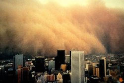 Figure 4. Dust storm over Melbourne, Australia. (Credit: Martin Williams)
 Most geoindicators can be tracked by inexpensive means, though some, such as the quality (chemistry) of soil, groundwater, and surface water may require complex and costly analyses. Some are quite simple, such as shoreline position, presence and condition of desert surface crusts, or groundwater level. Others are composites of many related processes, such as frozen ground activity, and volcanic unrest. Tracking geoindicators is generally non-destructive and has little environmental impact.
Measures of past abiotic change help to emphasize the importance of the recent geological archive for environmental monitoring. The task of establishing baseline trends is easier now that paleoenvironments can be deduced from coral growth rings, ice cores, lake sediments, cave deposits, and other proxies, with the kind of resolution that is useful for assessing short-term change. Such geoindicators can function as inexpensive, “automatic”, field recorders from which information on past environmental change can be extracted, just as tree-ring records are read.
Although the emphasis is on abiotic change, biological and geological systems interact intimately in time and space, so that it is not possible to ignore living organisms. This is especially so when dealing with deposits of organic origin such as peat and soil, the influence of animals and plants on weathering, erosion and deposition, or microbiota that play a mediating role in groundwater chemistry and karst processes. The role of human activities is discussed below.
Any such checklist or matrix gives the impression of separate and independent compartments. However, there are many interactions, as between surface water and groundwater, and between stream sediment transport and soil and sediment erosion. Few geoindicators are, thus, independent variables, and changes in one commonly affect others. For example, in deltaic regions coastal subsidence (the surface displacement geoindicator) may be related to changes in river channels (streamflow and stream channel morphology), loss of nearby marshes (wetlands extent, structure, hydrology), river sediment load (stream sediment storage and load), local sea level (relative sea level), and the location of beaches (shoreline position).
Applying Geoindicators
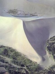 Figure 5. Star dune looming over and invading forest plantation, NW Gansu, China. (Credit: D. Zuo)
 In assessing the state of the environment (SOE), it is important to know whether change is being driven by physical, chemical or biological pressures. Are these human-induced or not, increasing or decreasing, and if so in what ways? Developed initially as tools for SOE reporting, geoindicators can be used to:
- Assess conditions of terrestrial and coastal environments on a wide range of spatial scales, from local to global.
- Answer the questions:
- What is happening in the environment?</dd>
- Why is it happening?</dd>
- Why is it significant?</dd>
- What are we doing about it?</dd>
- Establish baseline conditions and trends from past environments, so that human-induced and natural stresses can be better understood.
Geoindicators can be applied in urban and non-urban areas to determine important landscape changes in a way that can be reported in simple terms to planners and decision-makers. They can assist in ecosystem monitoring (Environmental monitoring and assessment), environmental impact assessments, determining forest renewal practices, and baseline surveys required for planning mining, land use changes, and construction of reservoirs, roads, canals, river diversion, and other engineering projects.
There are already many geological monitoring projects worldwide that study rapid change, but casting their results into this new framework can help to emphasize to non-geologists the importance of assessing rapid landscape change whether dealing, for example, with floods, sediment transport, or the response of groundwater quality to changes in land use. The geoindicator checklist has been a resource for environmental reporting in Argentina, Australia, Brazil, and Canada, and an aid for tracking changes in the environmental condition of national parks in the USA and Canada. Geoindicators have also been used in determining:
- the risk to groundwater contamination in Mar del Plata, Argentina,
- changes to karst landscapes in the USA and Lithuania,
- coastal hazards in Florida,
- land degradation around the city of Fortaleza, Brazil,
- stream sediment transport in Puerto Rico, and
- environmental change around municipalities in Finland.
Causes of Rapid Geological Change
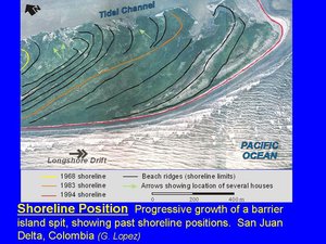 Figure 6. Rapid growth of barrier island and movement of shoreline, San Juan delta, Colombia. (Credit: Gloria Lopez)
 Despite the human footprint in nearly all landscapes, the geoindicator checklist emphasizes the importance of rapid natural change, for the condition of the environment at any time reflects not only human influences, but also background natural processes. Ground subsidence, seismicity, and slope failure are all natural processes that can also be triggered directly or indirectly by human action. Indeed, every geoindicator can change rapidly in the absence of human action, but only a few, such as volcanic unrest (eruptions) and glacier fluctuations, have never been directly driven by direct human activity. An attempt to show the relative importance of natural forces and human-induced stresses in causing rapid abiotic landscape change is shown in " rel="nofollow|Table 2.
Away from obvious sources of disturbance (e.g. towns, waste disposal sites, factory complexes, mines, farms, forest harvest areas), it can be very difficult to distinguish changes induced by human actions from those that might have occurred in the same place and time span in the absence of people. Thus, dealing with land use change, referring to human alterations of the Earth's terrestrial surface, requires an ability to distinguish non-human from human-induced modifications, as does desertification or climate change.
Rapid changes are common in many river systems, as people who live near them know full well. The shape and dimensions of stream channels and the capacity of rivers to store and discharge sediments may be altered as a result of dams and reservoirs, irrigation systems, and river diversions. They may also result from variations in rainfall and flash floods, failure of watershed slopes, or changes in glacial sources. Moreover, rivers can undergo sudden and permanent changes in flow paths and river-bed patterns related to the internal dynamics of fluvial flow.
Earthquakes are natural phenomena, but in the near-surface they can also be induced by surface loading of water in reservoirs, or around oil fields where fluids are pumped from the sub-surface. The underground dissolution of limestone and other readily soluble rocks (karstification), which leads to the development of collapse features such as sinkholes, can result from the high discharge of underground streams, but it can also be induced by over-pumping of groundwater. Soils can be degraded by farm tillage, road operations, and by acidification from fertilizers and acid rain, but their physical and chemical properties can also be modified by soil organisms and by drought, windstorms, and wildfires.
Many changes in geoindicators are related to variations in surface temperature, precipitation, and wind patterns, that is to weather and climate conditions. However many also take place in periods when climate (weather averaged over time) is relatively stable. Examples include the quality of surface and groundwater, the movement of sediment in rivers, dust transport, sea level, shoreline migration, earthquakes, avalanches, volcanic eruptions, and floods.
Geoindicators and Ecosystems
 Figure 7. Church in Mexico City (1966) tilted by surface subsidence due to groundwater withdrawal. (Credit: A. R. Berger)
 Long-term ecological monitoring (Environmental monitoring and assessment) aims to provide the background information for anticipating change and to assist the restoration of degraded ecosystems. The key question is whether the condition of ecosystems is being maintained, reduced or enhanced. Since no organism can exist or function without drawing upon rocks, soils, air and water, it is clearly essential to take into account abiotic components, especially those that are liable to change rapidly.
A guiding principle commonly used in environmental management is that of maintaining “ecological integrity”. Canada defines this in legal terms as “a condition that is determined to be characteristic of its natural region and likely to persist, including abiotic components.” The challenge that arises here is how to reconcile the reality of short- and long-term change with the management goal of continuity, even allowing for limited change within system boundaries. It may be asked what integrity remains in a tropical island ecosystem drowned by rising sea level, a savanna over-run by migrating sand dunes, a glacial foreland bared or buried by retreating or surging ice, or a permafrost terrain melting in response to climate warming. Other definitions of ecological integrity refer to ecosystem structures and functions that remain unimpaired by human stresses. This view raises the question as to the integrity of ecosystems impaired by the kind of non-human, natural stresses laid out in the geoindicator checklist. Of course, some natural and even some human-induced stresses can also be rejuvenating. Rivers flooding over farmlands may destroy crops and property, but can also be a source of new nutrients to enhance the productivity of the same fields. Forest fires destroy trees, plants, animals, and property, but may also be required for forest regeneration.
Rapid Landscape Change: Drivers and Responses
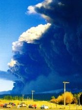 Figure 8. Cloud of volcanic ash ejected from Mt. Ruapehu, New Zealand, 1996. (Source unknown)
 It is common in SOE reporting and discussions of sustainability to use some version of a pressure-state-response conceptual framework, in which the term pressure is commonly replaced by driving force, generally referring to human actions. The difficulty with this scheme is that the condition of most environments at any time reflects not only human stresses but also natural processes, which may be causing change whether or not people are present. Curbing harmful human stresses on the environment, especially in rural and wilderness areas, may require the capacity to distinguish the effects of human actions, which can be controlled, from natural influences, which often can not. Similarly, environmental policies (responses) are mainly directed to human actions rather than to non-biological stresses, and commonly marginalize the impact of natural environmental processes and phenomena, such as tsunami, earthquakes, or sea-level change, on the condition (state) of the environment.
Another difficulty is that establishing cause and effect may be extraordinarily difficult in multi-component systems, where the response to any imposed stress, whatever its source, may be a stress on a different part of the ecosystem from another perspective. A volcanic eruption can perturb both global and local ecosystems, through impacts on regional weather patterns and air quality, local slope stability, fluvial systems, soil quality, [[glacier]s], and hill slope erosion. Likewise, lake ecosystems are affected by changes in lake levels, which may be intimately connected with weather patterns, fluctuations in groundwater levels and quality, wind erosion, or dust storms. Rising or falling relative sea levels influence shoreline position and coastal and estuarine environments, and can affect local stream flow and groundwater quality, or cause surface uplift or subsidence.
TablesTABLE 1. Geoindicators and (in brackets) some associated environmental changes, in addition to climate and weather patterns. CryosphereFrozen ground activity - freezing and thawing of surface materials, melting of permafrost, and ground heaving and subsidence (surface and groundwater circulation, land surface degradation)Glacier fluctuations - advancing or retreating ice sheets and valley glaciers (surface albedo, river runoff, sea-level) Arid & Semi-Arid Zones Desert surface crusts & fissures - development of cracks and biological crusts (biological productivity)Dust storm magnitude, duration, & frequency - movement of wind-blown dust (atmospheric transport of particulates, land use)Dune formation & reactivation - movement and stabilization of sand (wind speed and direction, moisture, sediment availability)Wind erosion - abrasion of rocks and soils by wind-blown particles (land use, vegetation cover) Marine & Coastal Zones Coral chemistry & growth patterns - annual growth layers preserving traces of surrounding environmental conditions (surface water temperature, coastal pollution, salinity)Relative sea level - rise or fall of sea level in one coastal area relative to another (coastal subsidence and uplift, fluid withdrawal, sedimentation and compaction)Shoreline position - movement of shoreline through erosion or accretion, regional subsidence or sea level change (coastal erosion, land use, sea level, sediment transport and deposition) Lakes Lake levels and salinity - rise or fall of lakes and changes in water chemistry (land use, streamflow, groundwater circulation)Wetlands Wetland extent, structure & hydrology - expansion or reduction of swamps, bogs, mangroves and other wetlands, variations in water content (land use, biological productivity, streamflow)Rivers & Streams Streamflow - changes in volume of flowing water, including flooding and drying out (basin discharge, land use)Stream channel morphology - shape and position of active streams (sediment load, flow rates, land use, surface displacement)Stream sediment storage & load - movement and deposition of sand, silt and gravel by rivers (flow rates, land use, basin discharge)Surface & GroundwaterKarst activity - underground dissolution of easily soluble rocks (groundwater chemistry and flow, vegetation cover, stream processes)Surface water quality - changes in the chemistry of lakes, rivers and streams (land use, water-rock-soil interactions, flow rates)Groundwater quality - changes in the chemistry of underground water (land use, pollution, rock and soil weathering, acid precipitation, radioactivity)Groundwater chemistry in the unsaturated zone - changes in chemistry of water in soils (weathering, land use)Groundwater level - variations in the level of water in wells, springs and aquifers (withdrawal of water, recharge)SoilsSoil quality - changes in the texture and chemistry of soil (land use; chemical, biological and physical soil processes)Soil & sediment erosion - removal of soil and soft rock material (surface runoff, wind, land use)Natural Hazards Seismicity - natural and human-induced release of earth stresses (reservoir construction) Landslides & avalanches - downhill movement of rock, surface debris and snow avalanches (slope stability, earthquakes, land use)Volcanic unrest - changes in eruptive activity in and around volcanoes (near-surface movement, degassing of molten rock, sub-surface heat flow)Other Sediment sequence & composition - changes in the layers of sediment deposited at the surface (land use, erosion and depositioSurface displacement - ground uplift and subsidence (faulting, fluid extraction)Subsurface temperature regime - near surface changes in the pattern of the earth’s internal heat flow ( heat flow, vegetation cover, land use) Table 2. Relative importance of human vs non-human drivers of rapid geological changeS = Strongly influenced by; P = potentially influenced by; N = no substantial influence on. Geoindicator Natural Human Coral chemistry and growth patterns S S Desert surface crusts and fissures S P Dune formation and reactivation S P Dust storm magnitude, duration, frequency S P Frozen ground activity S P Glacier fluctuations S N Groundwater quality P S Groundwater chemistry unsaturated zone S S Groundwater level P S Karst activity S P Lake levels and salinity S S Relative sea level S P Sediment sequence and composition S S Seismicity S P Shoreline position S S Slope failure (landslides) S S Soil and sediment erosion S S Soil quality P S Streamflow S S Stream channel morphology S S Stream sediment storage and load S S Subsurface temperature regime S P Surface displacement S P Surface water quality S S Volcanic unrest S N Wetlands extent, structure, and hydrology S S Wind erosion S P (Geoindicators)
Note
Further Reading
- Berger, A.R. and W.J. Iams, editors. 1996. Geoindicators - assessing rapid environmental changes in earth systems. A.A. Balkema, Rotterdam.
- Berger, A.R. and R.A. Hodge, 1998. Natural change in the environment: A challenge to the pressure-state-response concept. Social Indicators Research, vol. 44, 255-265.
- D. Welch. 2003. Geoindicators for Monitoring Canada's National Park System. Geoscience Canada vol. 30 (1).
- Environmental Geology journal. 2002. Special Issue on Geoindicators, Vol. 42 (7), p709 ff.
External links
- Geoindicator.org. The geoindicator website, which includes the complete annotated checklist, and numerous articles on rapid geological change.
- Terrestrial Ecosystem Monitoring Sites: A database of sites and networks that carry out long-term, terrestrial in-situ ecosystem monitoring and research activities.
- The International Permafrost Association, which has many monitoring activities.
- The World Glacier Monitoring Service.
- The World Organization of Volcano Observatories, which monitors volcanic activity.