Ecoregions of Cameroon
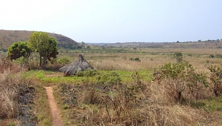
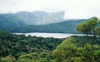
Countryside near Ngaoundal in Cameroon's Adamawa Province, within the Northern Congolian forest-savanna mosaic ecoregion. Source: Wikimedia Commons
Ecoregions of Countries Collection ![]()
Cameroon has twelve ecoregions that occur entirely or partly within its borders:
- Atlantic Equatorial coastal forest
- Central African mangroves
- Mount Cameroon and Bioko montane forests
- Cross-Sanaga-Bioko coastal forests
- Cameroonian Highlands forests
- Northwestern Congoloan lowland forests
- Northern Congolian forest-savanna mosaic
- Guinean forest-savanna mosaic
- East Sudanian savanna
- Mandara Plateau mosaic
- Sahelian Acacia savanna
- Lake Chad flooded savanna
Contents
- 1 Atlantic Equatorial coastal forest
- 2 Central African mangroves
- 3 Mount Cameroon and Bioko montane forests
- 4 Cross-Sanaga-Bioko coastal forests
- 5 Cameroonian Highlands forests
- 6 Northwestern Congoloan lowland forests
- 7 Northern Congolian forest-savanna mosaic
- 8 Guinean forest-savanna mosaic
- 9 East Sudanian savanna
- 10 Mandara Plateau mosaic
- 11 Sahelian Acacia savanna
- 12 Lake Chad flooded savanna
- 13 Context
- 14 References
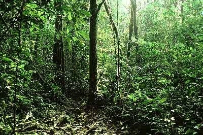
Atlantic Equatorial coastal forest
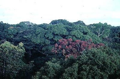 Canopy, Campo Reserve, Cameroon Photograph by David Olson This ecoregion extends from the Sanaga River in west-central Cameroon south to the Cabinda Province of Angola, ending in the extreme west Democratic Republic of Congo, just north of the mouth of the Congo River.
The Atlantic Equatorial Coastal Forests ecoregion has exceptionally high levels of species richness and endemism, contains large blocks of evergreen lowland moist forest, and the central portion has one of the lowest human population densities in Africa.
In terms of the flora, this area and the adjacent Cross-Sanaga-Bioko Coastal Forests ecoregion to the north support about 50 percent of the 7,000 to 8,000 plants endemic to tropical West Africa, mainly in the coastal area of Cameroon. Most of the floral and faunal assemblages are intact, including assemblages of threatened large mammals, such as the western lowland gorilla (Gorilla gorilla gorilla), mandrill (Mandrillus sphinx), and sun-tailed monkey (Cercopithecus solatus). Important centers of endemism are found in this ecoregion, particularly in some of the coastal mountain ranges.
Although considerable areas of rainforest still remain in southern Cameroon, Gabon, and the Republic of Congo, most of these areas have been selectively logged, some several times over. Logging has been particularly severe in Equatorial Guinea, which has lost approximately half of its forest cover, and logging is now becoming widespread in Cameroon and Gabon. Major protected areas in the northern part of the ecoregion are the Campo-Maan National Park and Douala-Edéa Wildlife Reserve in Cameroon.
Central African mangroves
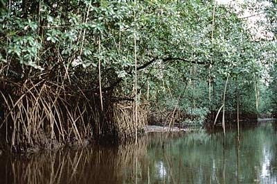 Ndian River Delta, Cameroon. Photograph by WWF/ Mauri Rautkari These mangroves flank the coastline of western and central Africa, in suitable low energy marine environments. The largest mangrove stand is found in the Niger Delta, which supports the most extensive area of mangrove in Africa. The mangroves of this region have no endemic species but support some endangered species, such as manatees and perhaps pygmy hippopotamuses in the Niger Delta. Mangroves are important as nursery and feeding areas for marine fishes, and they trap large amounts of sediment. The oil industry, clearance for salt pans, and overcutting by an increasing human population pose serious threats to these mangroves, but some are contained within protected areas.
In Cameroon, annual rainfall reaches 6,000 milimeters, but is highly changeable because of variation in topography and coastal types. These high freshwater inputs, together with a convergence of the Guinean counter-current, the Benguela current, and an equatorial subsurface current, creates a "piling up" of water that results in an increase in mean sea level of 1.2 m and creates an unusual circulation pattern. It also results in the formation of sandbars and the deposition of large amounts of suspended sediment in the mouths of estuaries.
The most important remaining blocks of habitat are found in the Niger River Delta in Nigeria, to the east of the mouth of the Cross River in Nigeria and Cameroon, and around Doula in Cameroon.
It is believed that 3,165 km2, or 10.68%, of the Central African mangroves, are in some form of Protected Area. These include the Douala-Edea Faunal Reserve in Cameroon (1600 km2).
Mount Cameroon and Bioko montane forests

This ecoregion is unique in west Central Africa in containing a continuous altitudinal gradient from low-altitude (above 200 m on the western slopes) moist forest to subalpine vegetation at the highest elevations.
While portions of this forest gradient persist intact, it is threatened at lower altitudes by subsistence and plantation agriculture.
The ecoregion contains exceptional levels of species endemism and richness, in part due to the great altitudinal range and the resulting diversity of [[habitat]s]. However, the forests of Bioko and Mount Cameroon are inadequately protected and threatened by conversion to agricultural lands, logging, and hunting (bushmeat).
The forests of Mount Cameroon are not currently protected under formal park status.
Cross-Sanaga-Bioko coastal forests
 Korup National Park, Cameroon Photograph by © WWF-Canon/Mauri Rautkari The Cross-Sanaga-Bioko Coastal Forests ecoregion comprises the lowland and coastal forests of southeastern Nigeria, southwestern Cameroon, and the lowlands of the island of Bioko.
The flora includes high numbers of endemic genera, indicating a long history of forest cover. These forests contain some of the highest rates of animal species richness of any African forest, especially in terms of forest-restricted mammals, birds, and butterflies. Many of these animals are endemic to this ecoregion or to the contiguous Atlantic Coastal Forests Ecoregion, but others are found more widely across the Congo Basin.
The ecoregion is heavily impacted by human use, including logging and plantation agriculture.
Despite much deforestation, there are still extensive areas of rainforest remaining in this ecoregion, particularly in the border region between Cameroon and Nigeria. Sayer et al present a map of the remaining forest cover from the late 1980s. At that time the main habitat blocks were between Oban and Obubra in southeastern Nigeria, and northeast along the border between Cameroon and Nigeria. An update of this work confirms that the same areas still have the largest remaining patches of forest.
There are also a number of forest blocks around Korup National Park, which is itself one of the largest protected areas in this ecoregion at 1,259 square kilometers (km2). Additionally, there are a number of important forest reserves in the ecoregion. The most significant is the Takamanda Forest Reserve in Cameroon, which is contiguous with the Okwangwo division of the Cross River National Park.
A number of spectacular primate species in this ecoregion could make suitable flagships for conservation investment, most notably the isolated population of lowland gorilla and the drill.
Cameroonian Highlands forests
 Lake Oku and Mt. Kilum, Cameroon Photograph by © WWF-Canon/Meg Gawler The Cameroon Highlands ecoregion comprises montane forest/grassland patches mainly above 900 meters (m) elevation, scattered in an archipelago along the border area between Nigeria and Cameroon.
Habitat ranges with increasing altitude from sub-montane to montane forests and ultimately subalpine grasslands. The forests and grasslands contain exceptional levels of endemism in all taxa.
The forests and montane grasslands in the ecoregion are poorly protected by reserves, but in some areas there is good traditional protection.
While the different mountains and highlands that comprise this ecoregion are naturally geographically isolated, human activities are increasingly fragmenting, degrading, and isolating the remaining forest patches. The area around Mount Oku in the Bamenda-Banso Highlands supports some 100 square kilometers (km2), and there are other patches in this region. The Bakossi Mts have at least 200 km2 of mid-altitude and montane forest above the altitude of 1,000 meters (m); and the lowland forest ("Western Bakossi") covers some 400 km2. The Mt. Nlonako Faunal Reserve also contains a partial forest continuum from the montane section to the lower levels. Tchabal Mbabo, in the northern sector, has almost 50 km2 of virtually pristine montane forest.
Due to high population pressures the remaining natural [[habitat]s], especially the forests, are threatened by agricultural expansion.
Northwestern Congoloan lowland forests
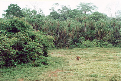 Forest buffalo in Lobéké National Park, East Province, Cameroon. Source: Wikimedia Commons The Northwestern Congolian Lowland Forests ecoregion stretches across four countries - Cameroon, Gabon, Republic of Congo, and the Central African Republic (CAR). It is bordered to the north and south by forest-savanna mosaics and to the east by swamp forest, while the western limit grades gradually into the lowland rain forests of the Atlantic Equatorial coastal forest ecoregion.
The Northwest Congolian Lowland Forest ecoregion contains vast tracts of lowland forest, supporting core populations of the western lowland gorilla (Gorilla gorilla gorilla) and large numbers of forest elephant. Cameroon has 29 species of primate recorded from its forests.
Species richness and endemism are both high.
Important Bird Areas include Dja Faunal Reserve, Boumba-Bek, Nki, and Lobéké National Parks in Cameroon.
Logging concessions and associated bushmeat hunting and agricultural expansion are the main threats to the [[habitat]s] and species. There are some established protected areas, and the gazettement of new protected areas offers good potential for biodiversity conservation in the region.
Northern Congolian forest-savanna mosaic
This northern latitude forest-savanna mosaic occupies the eastern half of White’s Guineo-Congolian/Sudanian phytogeographical [[region]al] transition zone. Forming the northern border of the Congo watershed, it begins east of the Cameroon highlands and extends east through the Central African Republic, northeastern Democratic Republic of Congo and into southwestern Sudan and a sliver of north-western Uganda.
The Northern Congolian Forest Savanna Mosaic ecoregion includes the northernmost savanna woodlands in Africa. Unlike the Zambezian forest-savanna mosaics south and west of the Congo Basin, this narrow transition zone marks an abrupt habitat discontinuity between the extensive Congolian rain forests and Sudanian/Sahelian grasslands.
With their characteristically diverse habitat complexes, forest savanna mosaics support a high proportion of ecotonal habitats, which have high species richness and are possible locii of tropical differentiation and speciation.
Political and economic instability and population growth throughout Central Africa exert intense pressure on parts of this ecoregion, especially in the eastern portion.
The protected areas in this ecoregion are few and widely dispersed. Unprotected patches of suitable but imminently threatened habitat remains scattered throughout this region. For example, extensive fragmentation threatens the endemic plant communities of the Cameroon’s Adamaoua Plateau, which is largely unprotected. The focus of many of the protected areas has been to protect the remaining populations of large game species, often favoring the Isoberlinia woodlands over forest habitat. Garamba National Park in the Democratic Republic of Congo and Mbem-Djerem National Park in Cameroon are the only two areas that conserve the forest savanna transition zone.
Guinean forest-savanna mosaic
The Guinean Forest-Savanna Mosaic runs through West Africa, dividing the Guinean rain forest from the [[Sudan]ian] savanna. The interlacing forest, savanna, and grassland [[habitat]s] are highly dynamic, and the proportion of forest versus other habitat components has varied greatly over time.
These forest-savanna ecotones may offer critical habitat for differentiation and speciation. A number of large charismatic mammal species are found here, but national parks attract few visitors.
The protected areas system is under funded and only covers two percent of the area of this ecoregion.
East Sudanian savanna
This ecoregion lies south of the Sahel in central and eastern Africa, and is divided into a western block and an eastern block by the Sudd [[swamp]s] in the Saharan Flooded Grasslands ecoregion. The western block stretches from the Nigeria/Cameroon border through Chad and the Central African Republic to western Sudan. The eastern block is found in eastern Sudan, Eritrea, and the low-lying parts of western Ethiopia, and also extends south through southern Sudan, into northwestern Uganda, and marginally into the Democratic Republic of Congo around Lake Albert.
The East Sudanian Savanna is a hot, dry, wooded savanna composed mainly of Combretum and Terminalia shrub and tree species and tall elephant grass (Pennisetum purpureum). The habitat has been adversely affected by agricultural activities, fire, clearance for wood and charcoal, but large blocks of relatively intact habitat remain even outside protected areas.
Populations of some of the larger mammal species have been reduced by hunting, but good numbers of others remain. Although numerous protected areas exist, most are under-resourced "paper parks" with little active enforcement on the ground, and some have suffered from decades of political instability and civil unrest.
The poor infrastructure and inaccessibility of the region have resulted in little development of tourism and wildlife-related revenue generation schemes, with the notable exception of sport hunting in the Central African Republic. Considerable external support to this ecoregion from multilateral and bilateral aid agencies is likely to be needed for many years to maintain or improve current levels of biodiversity.
Mandara Plateau mosaic
The ecoregion is located along the border between northeastern Nigeria and northwestern Cameroon (11° N, 14° E). Found in the semi-arid tropics, the ecoregion is within the Sudano-Sahelian belt, and is wetter and more vegetated than the Sahelian zone to the north. It can be divided into three altitudinally distinct zones: mountains, plateau, and plains. Most of the botanical value lies in those highly restricted plateau areas above 1,200 meters (m) in elevation. All parts of this ecoregion are highly degraded.
While the Mandara Plateau Mosaic ecoregion has a long history of intense human use and habitation, its ecology is little known and poorly understood. The area is important because it contains a number of rare and endemic plants with affinities to the East African Mountains and the Highlands of Ethiopia.
The distinctive plant communities associated with the Mandara Plateau receive no protection from the current network of protected areas in the region. There is little available data on this ecoregion, and that which is available relates mainly to [[Cameroon]’s] 14 square kilometers (km2) Mozogo-Gokoro National Park, which is situated in the lower lying regions and is not fully representative of the ecoregion at large.
In 1998, Mozogo-Gokoro National Park had not been burnt for over 40 years, and as a result of this exclusion of fire, much of it has become far more densely wooded, with the establishment of dry thickets and the almost total elimination of grass cover. The woodland savanna is dominated by Acacia albida, with A. senegal, and A. nilotica also present. Other species include: Balanites aegyptiaca, Ziziphus spp., Crateva adansonii, Celtis integrifolia, Ficus spp., and Khaya senegalensis.
Recorded fauna include vervet monkey (Chlorocebus aethiops), patas monkey (Cercopithecus patas), olive baboon (Papio anubis), warthog (Phacochoerus aethiopicus), bushbuck (Tragelaphus scriptus), gray duiker, (Sylvicapra grimmia), and python (Python sebae). Although the park since its inception in 1932 has been treated effectively as a Strict Nature Reserve, with tourism prohibited, current plans are to open it for tourism.
Threats to biodiversity here include heavy grazing, unsustainable collection of firewood, and frequent burning.
Sahelian Acacia savanna
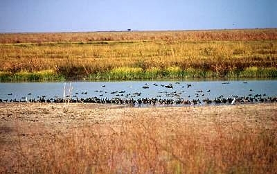 Waza-Logone floodplain, Cameroon Photograph by © WWF-Canon/Meg Gawler Spanning the entire African continent, the Sahelian Acacia Savanna stretches in a continuous band from the Atlantic Ocean to the Red Sea. Although not particularly rich biologically, these savannas once supported a large and diverse ungulate community.
The first European explorers to visit the region found vast herds of game, even larger in number than those of eastern and southern Africa. Sadly, these herds have been reduced to mere remnants due to nearly a century of unregulated over-hunting with modern firearms and vehicles, coupled with habitat loss.
Parks found in this area include the Waza and Kalamaloue National Parks in Cameroon.
Lake Chad flooded savanna
Lake Chad contains the boundaries of four African countries: Cameroon, Chad, Niger, and Nigeria. It is the largest lake in Central and West Africa and the fourth largest lake on the African continent. The lake’s waters presently cover 2,500 square kilometers (km2), only one-tenth the area they covered in the 1960’s.
This permanent shallow lake expands dramatically with seasonal floods, providing a vital refuge for birds migrating between the Palearctic and Afrotropical realms, and for resident animals. Up to one million waterbirds congregate on the lake in the Palearctic winter period.
Located on the southern edge of the Sahara, Lake Chad is also critically important to the people who inhabit its shores. In recent years, these wetlands have come under increasing pressure from drought, plans for water resource projects, and intensified anthropogenic use. An estimated 20 million people rely on Lake Chad/ Hadejia-Nguru for their economic activities, a figure that is projected to rise to 35 million by the year 2020.
The Lake Chad Game Reserve is currently the only protected area on Lake Chad. It occupies 7,044 km2 along 150 km of the western lakeshore in Nigeria, more than half the Nigerian shoreline of the lake. However, this reserve is a conservation area only in theory and that local communities have claimed the land for settlements, farms, cattle grazing and as bases for fishing.
Disagreements over water use can become volatile, sparking conflicts between neighboring provinces and countries. The Lake Chad Basin Commission was formed in 1964 to regulate and plan uses of the water and natural resources within the Lake Chad Basin.
Context
Ecoregions are areas that:
[1] share a large majority of their species and ecological dynamics;
[2] share similar environmental conditions; and,
[3] interact ecologically in ways that are critical for their long-term persistence.
Scientists at the World Wildlife Fund (WWF), have established a classification system that divides the world in 867 terrestrial ecoregions, 426 freshwater ecoregions and 229 marine ecoregions that reflect the distribution of a broad range of fauna and flora across the entire planet.
References
- Adegbehin, J.O., 1993. Mangroves in Nigeria. In E.D. Diop, editor. Conservation and Sustainable Utilization of Mangrove Forests in Latin America and Africa Regions. Part II – Africa. International Society for Mangrove Ecosystems and Coastal marine Project of UNESCO. Mangrove Ecosystems Technical Reports volume 3.
- Agyepong, G.T.K., P.W.K Yankson, and Y. Ntiamoa-Baidu, 1990. Coastal Zone Indicative Management Plan. E.P.C., Accra.
- Ajao, E.A. 1993. Mangrove ecosystems in Nigeria. In E.D. Diop, editor. Conservation and Sustainable Utilization of Mangrove Forests in Latin America and Africa Regions. Part II – Africa. International Society for Mangrove Ecosystems and Coastal marine Project of UNESCO. Mangrove Ecosystems Technical Reports volume 3.
- Appolinaire, Z. Mangroves of Cameroun. In E.D. Diop, editor. Conservation and Sustainable Utilization of Mangrove Forests in Latin America and Africa Regions. Part II – Africa. International Society for Mangrove Ecosystems and Coastal marine Project of UNESCO. Mangrove Ecosystems Technical Reports volume 3.
- Commission of the European Communities, Directorate-General for Development. 1992. Mangroves of Africa and Madagascar. Office for Official Publications of the European Communities. Brussels, Luxembourg. ISBN: 9282639843
- Diop, E.S., editor. 1993. Conservation and Sustainable Utilization of Mangrove Forests in Latin America and Africa Regions. Part II – Africa. International Society for Mangrove Ecosystems and Coastal marine Project of UNESCO. Mangrove Ecosystems Technical Reports volume 3.
- Elijah, A. 2001. Strategies for the sustainable management of mangrove resources in the Niger Delta. Discussion paper.
- Moreau R.E. 1966. The bird faunas of Africa and its islands. London: Academic Press. ISBN: 0125066503
- Morton, J.K. 1986. Montane Vegetation. In Lawson, G.W. (ed.) 1986. Plant ecology in West Africa: systems and process. John Wiley and Son, Chichester. ISBN: 0471903647
- Pérez del Val, J. 2001. Equatorial Guinea. Pp. 265-272 in L.D.C. Fishpool and M.I. Evans (eds). Important bird areas of Africa and associated islands: priority sites for conservation. BirdLife Conservation Series No. 11. Pisces Publications and BirdLife International, Newbury and Cambridge, UK.
- Putz, F.E., K.H. Redford, J.G. Robinson, R. Fimbel, and G.M. Blate. 2000b. Biodiversity conservation in the context of tropical forest management. Environment Department Papers. Biodiversity Series-Impact Studies. Paper No. 75. The World Bank, Washington DC.
- Ray, J.C., and R. Hutterer. 1996. Structure of a shrew community in the Central African Republic based on the analysis of carnivore scats, with the description of a new sylvisorex (Mammmalia; Soricidae). Ecotropica 1: 85-97.
- Reitsma, J.M. 1988. Forest vegetation of Gabon. Tropenbos Foundation, Ede, The Netherlands. ISBN: 9051130074
- Sayer, J.A., C.S. Harcourt, and N.M. Collins. 1992. The Conservation Atlas of Tropical Forests: Africa. IUCN and Simon & Schuster, Cambridge. ISBN: 0131753320
- Stattersfield, A.J., M.J. Crosby, A.J. Long, and D.C. Wege. 1998. Endemic bird areas of the world: priorities for biodiversity conservation. BirdLife Conservation Series No. 7., BirdLife International, Cambridge, UK.
- Stuart, S.N. and R.J. Adams (eds). 1990. Biodiversity in sub-Saharan Africa and its islands: conservation management and sustainable use. Occasional papers of the IUCN Species Survival Commission, Vol. 6. IUCN, Gland, Switzerland.
- White, F. 1983. The Vegetation of Africa: A descriptive memoir to accompany the UNESCO/UNFAT/UNSO vegetation map of Africa. UNESCO, Paris.