Ecoregions of Argentina
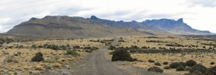
Patagonian steppe landscape in western Argentina. @ C.Michael Hogan
Ecoregions of Countries Collection ![]()
WWF identifies fourteen ecoregions the exist entirely or in part in Angentina:
- Araucaria moist forests
- Humid Chaco
- Arid Chaco (Chaco)
- Southern Andean Yungas
- Central Andean puna
- Central Andean dry puna
- Southern Andean steppe
- Argentine Monte (Low Monte)
- Argentine Espinal
- Humid Pampas
- Paraná flooded savanna
- Valdivian temperate forests
- Patagonian steppe
- Magellanic subpolar forests

Contents
- 1 Araucaria moist forests
- 2 Humid Chaco
- 3 Arid Chaco (Chaco)
- 4 Southern Andean Yungas
- 5 Central Andean puna
- 6 Central Andean dry puna
- 7 Southern Andean steppe
- 8 Argentine Monte
- 9 Argentine Espinal
- 10 Humid Pampas
- 11 Paraná flooded savanna
- 12 Valdivian temperate forests
- 13 Patagonian steppe
- 14 Magellanic subpolar forests
- 15 Protected Areas
- 16 Context
Araucaria moist forests
This ecoregion spans the mountainous areas of southern Atlantic Brazil and extends into northeastern Argentina. These forests are a relict of a once widespread ecosystem of mixed coniferous and broad-leafed trees, spread out across a mountainous landscape. Annual precipitation is high, and ranges from 1300-3000 millimeters (mm). Less than one percent of the ecoregion is covered by protected areas. More reserves are needed to save these biologically rich forest from illegal logging and urban expansion.Most of this ecoregion is on sedimentary rocks of the Paraná Plateaus.
The climate is subtropical with frequent frosts and with no dry season. Annual precipitation shows a significant variation between 1,300 mm and 3,000 mm. The main vegetation is Atlantic moist forest, with a particular 45-meter-tall emergent strata of the Brazilian Araucaria (Araucaria angustifolia). Canopy layers are rich in species of Lauraceae (Ocotea pretiosa, O. catharinense), Myrtaceae (Campomanesia xanthocarpa), and Leguminosae (Parapiptadenia rigida). These forests form complex mosaics of plant associations among the pioneer Brazilian Araucaria and tree species from different types of Atlantic forest. This moist forest ecoregion is recognized as an important Endemic Bird Area. It is also home for Atlantic endemic and threatened vertebrates such as the brown howler monkey (Alouatta fusca) and the red spectacled Amazon (Amazona petrei), which have few populations scattered in remnants of these forests.
Threatened vascular plant species also survive here, including the Brazilian Araucaria. From a evolutionary perspective, Brazilian Araucaria moist forests represent more widespread South America coniferous forests of the past and, therefore, have great importance for conservation. Illegal timber extraction and forest conversion into agricultural lands represent a large threat to the future of these forests because they possess fertile soils that are attractive to agricultural interests.
Humid Chaco
This region is a mosaic of ecosystems, combining woods with savanna. In this mosaic, various species of trees, shrubs, and coarse grass develop and are associated with numerous species of fauna adapted to this diverse environment. Poaching and exploitation of plants are the main threats to the natural habitat in this ecoregion, which has been considerably altered due to cattle raising. The Chaco Humedo ecoregion is located in northeastern Argentina, the center of Paraguay, and small areas in southwestern Brazil. The region slopes gently towards the east and overlooks areas full of depressions. The soils are generally sedimentary, originating from river flows and composed of fine materials. Precipitation varies between 1,300 millimeters (mm) annually in the east and 750 mm in the west.
The vegetation consists of xenophile forests mixed with palm savannas. The grasslands of this region are quite varied depending upon the soils. The fauna is very diversified resulting due to the heterogeneity of the habitat. Among the large mammals we find: maned wolf, black howler monkey, Azara's night monkey, pecaries, giant anteater, capybara, deer, marsh deer, pampas deer, puma, and jaguar. Some of the birds include the ñandú, Crypturellus undulatus, Celeus lugubris, Heterospizias meridionalis, and others. Dinerstein et al. have classified this ecoregion as vulnerable, and of importance on a local and a national scale. Cattle raising and forest exploitation have profoundly changed the composition of the vegetative communities either by destroying the herbaceous layer, eliminating the hardiest forest species or by burning all of the forest for agriculture. Commercial hunting and poaching threaten the fauna chaqueña. Illegal shipments of leather and furs violating the established quotas and/or containing threatened, and thus prohibited, species are found at ports.
Arid Chaco (Chaco)
The Guarani Indians initially described this region as "Gran Chaco", which implies productive hunting grounds. Today much of the northern Chaco is still abundant with large game mammals, suggesting sustainably harvested populations. However, this is no longer the case in much of the southern Chaco where rampant overgrazing and human population growth has preceded the pristine nature of the Chaco. An important migration route, many species of avifauna can be found in this ecoregion throughout the year. More protected areas are needed in order to save this habitat from overwhelming agricultural development.
The Chaco represents a region that was inadequately explored until recently, with new species of large vertebrates such as the Chacoan Peccary (Catagonus wagneri) being discovered as recently as the 1970’s. Moreover, new records of known species are increasingly documented as the international scientific community realizes more fieldwork-hours.
Argentina has several reserves in the Chaco, primarily in the northern Argentine Chaco (RN Formosa, PNs Pilcomayo, Baritú, Callilegua, El Rey, and RPs Agua Dulce, Potreros de Yala, El Bagual), with a couple in the central (RP Los Palmares and RP Copo) and southern (RP Chaco) [[region]s].
Southern Andean Yungas
This ecoregion is extremely fascinating from a biogeographic perspective, as it contains what may be the last of the isolated ‘evergreen’ forests resulting from Quaternary glaciations. This region is rich in fauna species, especially avifauna. Many tropical species meet their southern limits of geographic distribution in this region. The forests of Argentina have suffered more damage than Bolivia. A number of national parks protect the forest of this ecoregion.
This ecoregion essentially forms a mesic habitat that lies between two much drier habitats: the Chaco to the east, and the higher Puna to the west. The habitat is evergreen forest, with canopy height typically not exceeding 15 m. Between 1,200 – 2,500 m the forest is dominated by Andean Alder (Alnus acuminata) and Mountain Pine (Podocarpus parlatorei) or Queñoa (P. australis); at lower elevations these species form a mosaic with other trees, especially Lauraceae and Myrtaceae.
Central Andean puna
This ecoregion is a high elevation montane grassland in the southern high Andes, extending from southern Peru, though Bolivia, into northern Argentina. Open meadows are dotted with an assortment of rock, bunchgrass, herbs, moss, and lichens. The landscape is characteristically mountainous, with snow capped peaks, mountain pastures, high lakes, plateaus, and valleys. The Central Andean Puna, despite its characteristic dryness and because it still maintains nearly unaltered blocks of habitat, represents an important area for the **conservation of endemic species of both flora and fauna. Its climate varies from temperate to cold, it is dry with an average temperature between <0 and 15ºC. Precipitation varies between 250 and 500 millimeters (mm) per year.
This ecoregion rests on formations of volcanic origin subsequent to the formation of the Andes (about 6-8 million years ago). The vegetation is characterized by being notably drier than in the rest of the puna. This ecoregion faces increasing mining activity that is leading to the destruction of its scarce plant cover as well as the contamination of some bodies of water and the soil. In addition, this region has a large number of population centers and highways that cross the Andes, leading to a decline in natural habitat and growing pressures on the existing fauna. Fortunately, a portion of these habitats is represented within some existing protected natural areas and most plant formations are included in these areas. However, there are still some information gaps, particularly in the case of birds, and there are some priority areas to be preserved.
Central Andean dry puna
This ecoregion is a very dry, high elevation montane grassland and herbaceous community of the southern high Andes, extending through western Bolivia and northern Chile and Argentina. The vegetation is characteristically tropical alpine herbs with dwarf shrubs, and occurs above 3,500 meters (m) between the tree-line and the permanent snow-line. Dry puna is distinguished from other types of puna by its annual rainfall, or lack of rainfall. This ecoregion receives less than 400 millimeters (mm) of rainfall each year, and is very seasonal with an eight-month long dry season. The Central Andean Dry Puna is a unique ecoregion with flora and fauna highly adapted to the extreme temperatures and altitudes.
The Andes were formed by large introsions of igneous rock and volcanic activity. The formation was assumed its present form in the Tertiary period approximately 50 million years ago. This ecoregion encompasses many volcanic mountains and the high plateau to the east called the Altiplano. The region lies at an elevation of 3,500-5,000 meters (m) above sea level. The northern part of the ecoregion has a temperature ranging from 8 to 11°C; temperatures in the southern area are lower. The mid-southern sections of the ecoregion are drier than the north, with an annual precipitation that varies from 51 mm to 406 mm.
Southern Andean steppe
The southern Andean steppe ecoregion extends along the high elevations of the Andes of central Argentina and limiting areas of Chile, a generally dry area that includes many of the highest mountains of South America. Several plant genera that are characteristic of the ecoregion have evolved many endemic species in this area. The plants generally show adaptations to extreme dry conditions, cold and wind, and frequently have spines as anti-herbivore defenses and conspicuous flowers to attract pollinators (Pollinator). The fauna is related to that of limiting ecoregions, especially to that of central Andean dry Puna and to the Patagonian steppe.
Argentine Monte
The Argentine Monte is located in north-central Argentina, extending along the eastern foothills of the Andes until it reaches the Patagonian steppe, then extends eastwards to the Pacific Ocean. Here thorn scrub and dry grasslands are common. It is a warm scrub desert extending between the Puna, Patagonia, and Chaco ecoregions. The climate is temperate-arid with very little rainfall (between 80 and 250 millimeters per year). The northern and central regions of the Monte receive rain in summer but in the south is colder and rainfall is distributed throughout the year. The dominant vegetative formation of this ecoregion is scrublands, that at times can be very open. This ecoregion has several endemic species of flora and fauna. The insect fauna is quite well known from the northern part of the Monte where there are a high proportion of endemic genera (10%) and out of species (35%) belong to different families.
Human populations preferred to occupy oases in valleys and other locations close to rivers that make irrigation possible. This is why some sections of the ecoregion were intensively altered but others were not. The forest also underwent significant depredation as man occupied patches and used wood for vineyards, mining, furniture making, construction, and fuel. Overgrazing and deforestation has caused erosion that affected 58 million hectares of the ecoregion. The Monte, as well as in the Chaco and Patagonia lowland, is experiencing seriously damaging effects due to human activities, especially overgrazing by goats, sheep, and cattle; clear cutting for fuel; and land clearing for agriculture, mining, and oil exploration. The deforestation and selective extraction of hardwood and clear cutting of mesquite forests began at the late 19th and early 20th centuries and continues today.
Argentine Espinal
This ecoregion is described as an "espinal", literally meaning a thorny deciduous shrubland forest. The occurrence of this vegetation type is extensive from the central basin of the Paraná River (west of the flooded savannas) westward to the Córdoba Mountains. This region has become developed and cultivated and is threatened by agricultural expansion. In the northern section, the climate is warm and wet with summer rains. It is a mostly flat plain with low hilly areas. In the wetlands we find a very rich and varied fauna, including species adapted to saline environments. The number of avian species recorded is 138, among which we should emphasize the large reproductive colonies of the flamenco chileno (Phoenicopterus chilensis).
This ecoregion has been heavily modified as most of it has been used for agriculture and its forests have been highly exploited and dismantled. The carob tree is a species that has been much used by man, both for the shade it provides and for its fruit that is used as forage for livestock. The Espinal is protected in the Lihué-Calel National Park, La Reforma University Reserve, Chacharramendi Provincial Reserve, and Luro Provincial Reserve. A major threat to the Mar Chiquita lake and the floodplain of the Dulce River within this ecoregion is the growing use of its water by humans in the upper basin.
Humid Pampas
The Humid Pampas ecoregion occupy one of the most human populated areas in Argentina. The ecoregion consists of the plains, many rivers, and lagoons. The natural vegetation in the area is composed of grasslands and xeric woodland. There are various endemic animals that are threatened by habitat destruction and degradation. The ecoregion is considered endangered and is regarded as a high priority conservation area at the regional scale. The Humid Pampas occupy the plains in the east of Argentina, taking up most of the province of Buenos Aires. Horizontal plains and very soft undulations with low peaks that emerge like islands characterize the relief of this area. There are a few slow moving, undulating rivers and many lagoons with fresh and salt water. The pampas plains originated in packed sediment from a large sinking tectonic pit that extends to the Chaco. The climate is hot with rain throughout the year.
The pampas region lacks endemic vegetation of importance. Species in danger of extinction include the pampas deer, a very important herbivore in this area. Little is left of the natural habitat in the Humid Pampas. This is one of the most heavily populated areas of Argentina that has been extensively used for agriculture and cattle grazing. Natural vegetation grows in small patches that persist along the railroad tracks and in some abandoned fields left to rest for many years. Only certain species of animals live in this disturbed and altered habitat. The region has been classified as a maximum priority ecoregion at regional scale. There are two severe threats in the region: conversion of remaining natural habitats for agriculture and degradation through over-grazing are severe threats. Burning and draining of lands are also threatening remaining habitats that could possibly affect protected areas.
Paraná flooded savanna
This flooded savanna, fed by the Paraná river, is located in Argentina. Defined by a almost subtropical temperatures usually found much farther north, this region is rich in flora and fauna that is uncharacteristic of its surrounding regions. A number of national parks protect this habitat, which contains three endemic bird areas. The main threat to this ecoregion is the building of damsand dykes, while hunting, urban expansion, and pollution constitute other threats.
This region includes the floodplains of the middle and lower Paraná river and its tributary the Paraguay river. The southern section includes the Paraná delta and the la Plata river basin. The landscape of this region is represented by low islands that flood and are delimited by the lateral branches and major flows of the great rivers and extensive coastal lowlands.
The permanent presence of large bodies of water create local climatic effects with high ambient humidity and mitigate extreme daily and seasonal temperatures, allowing for the presence of communities and species typical of the humid subtropical regions of the country’s northeast.
The vegetation in this region consists of forest and shrublands in slender coastal strips on albardones Emerging from the water; scrublands and pastures on the islands in open waters; hydrophilic and aquatic communities on the shores of rivers and channels; and interior island lagoons.
The forests consist primarily of Salíx humboldtiana (sauce criollo or sauce colorado), Tessaria intergrifolia (aliso), Erythrina crista-galli (ceibo), etc. Aquatic communities include camalotes, primarily of the genus Eichhornia and Reussia, onagraceae like Victoria cruziana (irupé) with large plate-shaped leaves and white flowers with many petals; we also find Cyperus giganteus (pirí), Typha latifolia and T. Domingensis (totoras) and the beautiful blue-flowered pontederiacea Pontederia lanceolata (cucharero)
Valdivian temperate forests
The Valdivian temperate forests and the more hygrophilous vegetation of the Mediterranean area of central Chile, represent a true biogeographic island separated from climatically similar areas by extensive ocean barriers and deserts.
|
|
| Alerce trees, Lenca, Chile. (Photograph by Marco Cortez) |
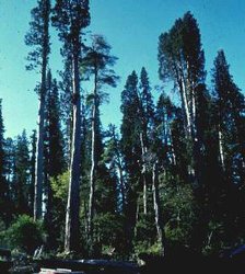
The Valdivian temperate forest is characterized by its extraordinary endemism (e.g., 90% at the
species level and 34% at the genus level for woody species) and the great antiquity of its biogeographic relationships.
Its taxons show close philogenetic relationships dating back to the early Tertiary, with Gondwanic taxons of Oceania forming more recent relationships with Neotropical taxons, separated from other biotas in South America by the great mountainous barrier of the Andes.
The region's ecosystems are frequently threatened and degraded. Urgent action has been recommended to restore the area's ecology and to preserve its remaining [[habitat]s].
Patagonian steppe
This ecoregion extents roughly from the mid-Andean Precordillera southward, ending just north of the Straights of Magellan near the Rio Gallegos. This steppe is bordered on the west by the cold temperate forest slopes of the Andes, and on the east by the Pacific Ocean. It extends north-west as shrubland steppe and to the north as thorn thicket, gradually making the transition to Argentine Monte. This area is a cold desert scrub steppe, with almost constant wind and year round frosts likely. This ecoregion has high levels of endemism in both plants and animals. This Patagonian steppe ecoregion mainly covers the Patagonia region of Argentina from the Atlantic Ocean shore to barely across the border into Chile. A characteristic of the Patagonian climate is the constant drying wind that blows with great force from the western sector, particularly in the summer months. Winter generally lasts for five months from about June to September with averages of the coldest month between 1-3°C below freezing. In general, the vegetation of this steppe ecoregion is xerophytic and highly adapted for protection against drought, wind, and herbivores.
In this ecoregion we find two endemic species of the genus Prosopis, one species of Larrea and species of the genera Lycium and Schinus. The Argentine coasts have high species diversity, including 33 species of cetaceans, 8 species of pinnipeds and more than 450 species of fish in the waters of the Argentine sea. Despite the low density of the human population, this ecoregion has been seriously affected due to the fragility of the environment. This ecoregion has many natural reserves. The major problem is desertification due to over-grazing primarily by sheep, damaging the limited plant coverage and exposing the soil to erosion. In addition, many species of fauna are now in regression due to the tempting prices paid for the skins of chulengos (baby guanacos) and choique rhea feathers. There is also pressure on foxes and pumas from hunting and/or poisoning because they are considered a potential threat to flocks.
Magellanic subpolar forests
The subpolar Nothofagus forests cover the western part of the southern end of South America. The ecoregion is colder and in parts drier than the Valdivian temperate forests, and in general is floristically poorer. The fauna is related to that of the bordering ecoregions, especially to that of the Valdivian temperate forests and the Patagonian steppe. Nevertheless, its varied and majestic landscapes that include high mountain peaks, enormous icefields, and innumerable fjords are inhabited by unique and endemic animal and plant species that are sometimes abundant within this ecoregion. The northern end of the subpolar Nothofagus forests limit with the Valdivian temperate forests and the eastern part with the Patagonian steppe and the Patagonian grasslands. Towards the west the region is in contact with the cold southern Pacific Ocean, and on the high Andes vegetation floristically related to the south Andean steppe appears in parts as interrupted islands.
Permanent snow, ice caps and glaciers are present in the summits of many of the higher elevations. The climate of this area is wet and temperate-cold and very cold at high elevations. The effect of the cold northward Humboldt and Antarctica currents on the western and southern coasts makes the area colder than others at similar latitudes, with mean January (summer) temperatures lower than 10º C. The strong westerly winds blow all year round, producing high rainfall in the windward west side of the mountains and lower precipitation to the east, and no dry season. The vegetation shows principally two types of forest, mainly evergreen Nothofagus betuloides forests to the west and deciduous Nothofagus pumilio and Nothofagus antarctica forests towards the east that extend into Argentina. In the colder areas with high rainfall of the south western most parts of the ecoregion a characteristic vegetation specially termed Magellanic moorland or Magellanic tundra extends through the Chilean archipielago to 48ºS. This tundra is characterized by prostrate dwarf shrubs, cushion plants, grass-like plants and bryophytes on water-logged terrain that in different combinations form vegetation of scrub or bogs. Important levels of endemism are found among plants, with several mostly herbaceous species being confined to the ecoregion.11. Paraná flooded savanna This flooded savanna, fed by the Paraná river, is located in Argentina. Defined by a almost subtropical temperatures usually found much farther north, this region is rich in flora and fauna that is uncharacteristic of its surrounding regions. A number of national parks protect this habitat, which contains three endemic bird areas. The main threat to this ecoregion is the building of dams and dykes, while hunting, urban expansion, and pollution constitute other threats. This region includes the floodplains of the middle and lower Paraná river and its tributary the Paraguay river. The southern section includes the Paraná delta and the la Plata river basin.
Fish perhaps define the most interesting and diverse group in this region with more than 300 species with a predominance of characiforms and siluriforms. Large infrastructure projects such as dykes, dams, waterways, roads, etc. represent a great threat to the flora and fauna of Argentina. In the case of this region, we should add petroleum and mining operations, agriculture, urban expansion, pollution, habitat fragmentation, and poorly-managed tourism. Commercial hunting and poaching also threaten wildlife as illegal shipments of hides and skins, in violation of established quotas and/or involving the hunting of prohibited species, are often detained.
Protected Areas
- Iguazú National Park
- Ischigualasto-Talampaya
- Los Glaciares National Park
- Pali Aike volcanic formations (straddles border with Chile)
- Península Valdés
- Tierra del Fuego National Park
See also:
- Patagonian Shelf large marine ecosystem
Context
Ecoregions are areas that:
[1] share a large majority of their species and ecological dynamics;
[2] share similar environmental conditions; and,
[3] interact ecologically in ways that are critical for their long-term persistence.
Scientists at the World Wildlife Fund (WWF), have established a classification system that divides the world in 867 terrestrial ecoregions, 426 freshwater ecoregions and 229 marine ecoregions that reflect the distribution of a broad range of fauna and flora across the entire planet.
 Image by Raul Senzacqua