Argentine Espinal
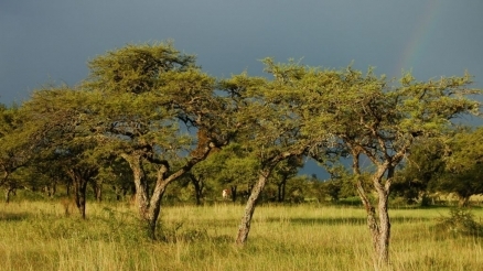
This ecoregion is described as an "espinal", literally meaning a thorny deciduous shrubland forest. The occurrence of this vegetation type is extensive from the central basin of the Paraná River (west of the flooded savannas) westward to the Córdoba Mountains. This region has become developed and cultivated and is threatened by agricultural expansion.
Location and General Description
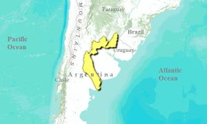
This Argentine espinal ecoregion is located in central Argentina extending from central Santa Fe through the province of Córdoba to the north of San Luis. In the northern section, the climate is warm and wet with summer rains. As happens with other phytogeographic provinces, it has great temperature variations and high average precipitation. It is a mostly flat plain with low hilly areas. Soils are loessoid or sandy.
The vegetation is characteristic of deciduous xerophytic forests, palm groves, grassy savannas, grassy steppes, bushy steppes. Espinal is characterized by the dominance of arboreal species of the genus Prosopis in the climax communities. Mimosoideae leguminosae of the genera Prosopis and Acacia are generally predominant, accompanied by other "chaco type" genera such as Jodina, Celtis, Schinus, Geoffroea, Atamisquea, and others.
The espinal ecoregion can be divided into two subregions, the carob subregion in the north and the caldén subregion in the south. In the first, the dominant arboreal species include Prosopis nigra (algarrobo negro), Prosopis alba (algarrobo blanco), Celtis tala (tala), Geoffoea decorticans (chañar), Acacia caven (espinillo), Jodina rhombifolia (sombra de toro), Scutia buxifolia (coronillo), and Schinus longifolia (incienso). In certain areas there are still caranday palms (Trithrinax campestri) that are isolated or in colonies which occur now as relicts. The caldén subregion is characterized by the abundance of calden trees (Prosopis caldenia) forming more or less dense xerophytic forests. There are also clearings covered by grassy savannas, dunes with ammophilous vegetation and salty soils with scrublands or halophilic steppes.
Biodiversity Features
The plant species found in the espinal are generally also found in other phytogeographic [[ecoregion]s] of Argentina, particularly the chaco region of which it is considered an impoverished southern continuation. According to studies conducted by the International Council for Bird Preservation, there are three species of endemic birds in this ecoregion. There are very few endemic taxons in this ecoregion. The caldén trees (P. caldenia) are one of the few examples of a species confined to this ecoregion.
This ecoregion includes one of the most important wetlands, Mar Chiquita lake and the swamps of the Dulce river, a Ramsar site that is included as a key site for endangered birds of the Neotropics. In these wetlands we find a very rich and varied fauna, including species adapted to saline environments. The number of avian species recorded is 138, among which we should emphasize the large reproductive colonies of the flamenco chileno (Phoenicopterus chilensis).
Current Status
This ecoregion has been heavily modified as most of it has been used for agriculture and its forests have been highly exploited and dismantled. Both the caldenal and the talares types of sparse xerophytic forests that have been exploited for the removal of firewood. The caldén trees have also been used to obtain fence posts, make wooden paving blocks for streets and to operate sawmills for making parquet floors. Now the caldén trees are seriously threatened by the expansion of the agricultural frontier that, thanks to modern irrigation systems, are now reaching areas that in the past were not suited for this type of land management. The carob tree is another species that has been much used by man, both for the shade it provides and for its fruit that is used as forage for livestock. The crushed shells or "chauchas" are used to make sweets (patay) and when allowed to ferment produce a refreshing beverage called "aloja". Its wood was used to construct ranch houses and rustic furniture. It is currently used to make furniture and is thus increasingly threatened.
The Espinal is protected in the Lihué-Calel National Park, La Reforma University Reserve, Chacharramendi Provincial Reserve, and Luro Provincial Reserve.
Types and Severity of Threats
A major threat to the Mar Chiquita lake and the floodplain of the Dulce River within this ecoregion is the growing use of its water by humans in the upper basin.
Justification of Ecoregion Delineation
The delineations for the Argentine Espinal were derived from Daniele and Natenzon, and linework follows their classification of "Espinales y Algarrobales Pampeanas" region. Other resources consulted include Cabrera and Morello.
Additional information on this ecoregion
- For a shorter summary of this entry, see the WWF WildWorld profile of this ecoregion.
- To see the species that live in this ecoregion, including images and threat levels, see the WWF Wildfinder description of this ecoregion.
- World Wildlife Fund Homepage
Further Reading
- Anderson, D.L., Del Águila, J.A. y A.E. Bernardón. 1970. Las formaciones vegetales de la Provincia de San Luis. Rev. Inv. Agropecuaria INTA, serie 2, Biología y Producción Vegetal, 7(3): 83-153.
- Bucher, E.H. 1997. Predicted impacts on Freshwater ecosystems in Latin American. Pages 7-11 in The impact of the water crisis on freshwater ecosystem in Latin American and the Caribbean: Predicted trends and proposed policy responses. Washington: World Wildlife Fund.
- Cabrera, A.L. y A. Willink. 1980. Biogeografía de América Latina. O.E.A. Serie Monográfica N? 4. Washington D.C.
- Cabrera, A.L. 1976. Regiones Fitogeográficas de Argentina. Enciclopedia Argentina de Agricultura y Jardinería. Tomo II. Fascículo I. Editorial ACME S.A.C.I. 85pp.
- Cabrera, A.L. 1976. Regiones fitogeográficas Argentinas. Enciclopedia Argentina de Agricultura y Jardinería, Second Edition, Vol. II, Buenos Aires, Argentina.
- Canevari P., D.E. Blanco, E. Bucher, G. Castro y I. Davidson. 1998. Los Humedales de la Argentina. Clasificación, situación actual, conservación y legislación. Wetlands International. Publicación N? 46. 208pp.
- Cano, E. y C. Movia. 1967. Utilidad de la fotointerpretación en la cartografía de comunidades vegetales del bosque de caldén (Prosopis caldenia). INTA. Instituto Botánico Agrícola. La vegetación de la república Argentina. 8:1-44.
- CIPA 1992. Putting biodiversity the map, priority areas for global conservation. ISBN: 0946888248
- Daniele, C., and C. Natenzon. 1994. Regiones Naturales de la Argentina. Draft map. Argentina National Parks Department, Buenos Aires, Argentina.
- Morello, J. 1968. La vegetación de la República Argentina, No. 10: Las grandes unidades de vegetación y ambiente del Chaco Argentino. Buenos Aires, Argentina.
| Disclaimer: This article is taken wholly from, or contains information that was originally published by, the World Wildlife Fund. Topic editors and authors for the Encyclopedia of Earth may have edited its content or added new information. The use of information from the World Wildlife Fund should not be construed as support for or endorsement by that organization for any new information added by EoE personnel, or for any editing of the original content. |

