Eastern Himalayan broadleaf forests

From The Encyclopedia of Earth
Jump to: navigation, search


May 8, 2014, 4:04 pm
Content Cover Image

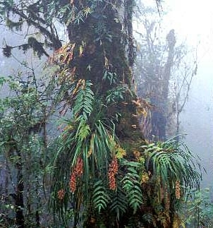
Makalu-Barun National Park, Nepal Photograph by Chris Carpenter

The Eastern Himalayan Broadleaf Forests is one of the few Indo-Pacific ecoregions that is globally outstanding for both species richness and levels of endemism. The eastern Himalayas are a crossroads of the Indo-Malayan, Indo-Chinese, Sino-Himalayan, and East Asiatic floras as well as several ancient Gondwana relicts that have taken refuge here. Overall, this ecoregion is a biodiversity hotspot for rhododendrons and oaks; for instance, Sikkim has more than fifty rhododendron species, and there are more than sixty species in Bhutan.

In addition to the outstanding levels of species diversity and endemism, the ecoregion also plays an important role in maintaining altitudinal connectivity between the habitat types that make up the larger Himalayan ecosystem. Several birds and mammals exhibit altitudinal seasonal migrations and depend on contiguous habitat up and down the steep Himalayan slopes for unhindered movements. Habitat continuity and intactness are also essential to maintain the integrity of watersheds along these steep slopes. If any of the habitat layers, from the Terai and Duar grasslands along the foothills through the broadleaf forests and conifers to the alpine meadows in the high mountains, are lost or degraded, these processes will be disrupted. For instance, several bird species are found in the temperate broadleaf forests of Bhutan where the habitat is more intact and continuous with the subtropical broadleaf forests lower down, but in Nepal where the habitat continuity has been disrupted, these same birds have limited ranges.

Location and General Description
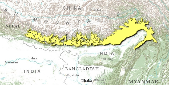
Eastern-himalayan-broadleaf-forests-map.jpg

This ecoregion represents the band of temperate broadleaf forest between 2,000 and 3,000 meters, stretching from the deep Kali Gandaki River gorge in central Nepal, eastward through Bhutan, into India's eastern states of Arunachal Pradesh and Nagaland. Champion and Seth identified a number of broadleaf forest types across the midelevations (1,500-3,000 meters) of the Himalayas: the east Himalayan moist mixed deciduous forests, east Himalayan wet temperate forests, Naga Hills wet temperate forests, Alder forests, east Himalayan oak-rhododendron forests, and Himalayan temperate parkland.

The Himalayas themselves trace their origin to the collision between the Eurasian continent and the northward-drifting Deccan Plateau more than 50 million years ago. The northern edge of the Deccan Plateau pushed beneath the Eurasian continent to raise the latter from beneath the Tethys Sea to create what is now the Tibetan Plateau. During this and three subsequent periods of geologic upheaval and uplift, the Himalayas were thrust upward to form the highest mountain range in the world.

The Himalayan Mountain Range comprises three east-west-directed parallel zones. The southernmost outer Himalayas, or Siwaliks, lie alongside the Indo-Gangetic Plain and is composed of alluvial deposits that have washed down from the north. It is more recent in origin than the other ranges. The next is the Middle Himalayas, a highly folded system of ridges and valleys that rise to about 5,000 meters. The third is the Inner Himalayas, which contain the tallest mountains in the world: Everest, Makalu, Dhaulagiri, and Jomalhari.
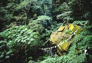
300px-KembalungNepal.jpg Kembalung, Nepal (Photograph by Chris Carpenter)

The monsoon rains provide about 2,000 millimeters of precipitation from May to September. Because these monsoons are funneled in from the Bay of Bengal, the eastern Himalayas receive the greatest rainfall, with a progressively drier trend toward the west. Thus, precipitation, topography, and temperature combine to influence the vegetation across this ecoregion.

Two distinct ecological formations of broadleaf forests can be distinguished in this ecoregion depending on the geology and slope (moisture regime): the temperate evergreen forests of oaks (Quercus spp.), especially Quercus lamellosa in association with Lithocarpus pachyphylla, Rhododendron arboreum, Rhododendron falconeri, Rhododendron thomsonii, Michelia excelsa, Michelia cathcartii, Bucklandia populnea, Symplocos cochinchinensis, and other species of Magnolia, Cinnamomum, and Machilus; and temperate deciduous forests dominated by Acer campbellii, Juglans regia, Alnus nepalensis, Betula alnoides, Betula utilis, and Echinocarpus dasycarpus.

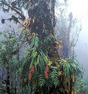
In the wetter parts of eastern Nepal, the forests are composed of a Magnolia-Acer-Osmanthus association, characterized by Magnolia campbellii, Acer campbellii, Osmanthus suavis, Schefflera impressa, and Corylus ferox. Common herbs the include Luculia gratissima, Lilium wallichianum, Pipanthus nepalensis, and Aster himalaicus, which form a ground cover. Shrestha and Joshi (1997) have reported that an understory of bamboo (Arundinaria spp. and Bambusa spp.) or species of Symplocos, Eurya, Rhododendron, Acer, Alnus, Carpinus, and Prunus can also be present in some areas in these elevations in eastern Nepal. In mature forests, the trees are draped with mosses, ferns, and other epiphytes.

Biodiversity Features

The Eastern Himalayan Broadleaf Forests is globally outstanding for both species richness and endemism, especially for its flora. It contains several localized areas of floral richness and endemism-floral hotspots-which are especially rich in rhododendrons and oaks.

The 125 mammal species known to occur in here include four species that are endemic to the ecoregion (Table 1).

Table 1. Endemic and Near-Endemic Mammal Species. Family Species Cercopithecidae Semnopithecus geei Sciuridae Petaurista magnificus Sciuridae Biswamoyopterus biswasi* Muridae Niviventer brahma An asterisk signifies that the species' range is limited to this ecoregion. Three of these species are shared with adjacent ecoregions (Eastern Himalayan broadleaf forests) , but the Namdapha flying squirrel, Biswamoyopterus biswasi, is a strict endemic whose range distribution is limited to the Eastern Himalayan Broadleaf Forests. The golden langur is limited to the broadleaf forests to the north of the Brahmaputra River, which flows along the foothills and between the Sankosh and Manas rivers, which flow south from the mountains. Therefore, despite being shared between this ecoregion and the adjacent Himalayan Subtropical Broadleaf Forests, the golden langur has a very limited range distribution.
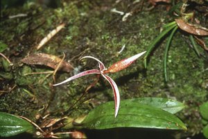
300px-Orchidspeciesbhutan.jpg Orchid species, Bhutan (Photograph by WWF)
The ecoregion also harbors several threatened species, including the endangered tiger (Panthera tigris), red panda (Ailurus fulgens), takin (Budorcas taxicolor), and serow (Capricornis sumatraensis) and the vulnerable Vespertilionidae bat (Myotis sicarius), Assamese macaque (Macaca assamensis), stump-tailed macaque (Macaca arctoides), wild dog (Cuon alpinus), back-striped weasel (Mustela strigidorsa), clouded leopard (Pardofelis nebulosa), and Irrawaddy squirrel (Callosciurus pygerythrus). The ecoregion overlaps with a high priority (Level I) Tiger Conservation Unit, a landscape with the ecological resources to support a viable tiger population over the long term. It also represents the only opportunity to conserve a tiger population that is adapted to survive in these Himalayan temperate broadleaf forests, where, unlike the productive habitats in the Terai and Duar grasslands and tropical dry forests, the tiger's prey densities are much lower. Under these conditions, the tigers are considered to have adapted their territory size, reproductive strategies, and hunting strategies to these ecological conditions. The red panda is more characteristic of the sub-alpine fir forest ecoregion adjacent to and above this temperate broadleaf forest ecoregion. In this broadleaf forest ecoregion, the red panda is limited to patches of mature fir (Abies) forests with a bamboo understory. There are almost 500 bird species, among the highest across the ecoregions in this bioregion. Twelve species are endemic to the ecoregion (Table 2). Of these, eleven are near-endemic species, and one, the rufous-throated wren-babbler, is a strict endemic that is restricted to the Eastern Himalayan Broadleaf Forests. {| border="1" cellpadding="3" align="center" ! colspan="3" align="center" | Table 2. Endemic and Near-Endemic Bird Species. Family Common Name Species Phasianidae Chestnut-breasted partridge Arborophila mandellii Timaliidae Hoary-throated barwing Actinodura nipalensis Timaliidae Ludlow's fulvetta Alcippe ludlowi Turdidae Rusty-bellied shortwing Brachypteryx hyperythra Timaliidae Elliot's laughingthrush Garrulax elliotii Paradoxornithidae Grey-headed parrotbill Paradoxornis gularis Timaliidae Immaculate wren-babbler Pnoepyga immaculata Sylviidae Grey-crowned prinia Prinia cinereocapilla Timaliidae Mishmi wren-babbler Spelaeornis badeigularis Timaliidae Rufous-throated wren-babbler Spelaeornis caudatus* Timaliidae Snowy-throated babbler Stachyris oglei Timaliidae Spiny babbler Turdoides nipalensis An asterisk signifies that the species' range is limited to this ecoregion. The bird assemblage also includes several threatened species of pheasants, tragopans, and hornbills that need mature forests and have low tolerances for disturbance. These species, namely the globally threatened rufous-necked hornbill (Aceros nipalensis) and Sclater's monal (Lophophorus sclateri), and the threatened white-bellied heron (Ardea insignis), Blyth's tragopan (Tragopan blythii) and Ward's trogon (Harpactes wardi), therefore can be considered indicators (Eastern Himalayan broadleaf forests) of habitat integrity and deserve conservation attention. The ecoregion also overlaps with BirdLife International's Endemic Bird Area, Eastern Himalayas (130). ==Current Status== About two-thirds of this [[ecoregion]'s] natural habitat is still intact, with most of the remaining large habitat blocks located in northeastern India and Bhutan. Even though the species-rich Quercus lamellosa forests are quite well represented within protected areas, the Quercus lanata forests in the lower elevations are not. Many of the small areas that remain are so badly degraded that restoration should be considered as a conservation option. Mt. Phulchowki, in the Kathmandu valley, represents an important area of habitat that is currently unprotected and highly threatened. {| border="1" cellpadding="3" align="center" ! colspan="3" align="center" | Table 3. WCMC (1997) Protected Areas That Overlap with the Ecoregion. Protected Area Area(km2) IUCN Category Eagle Nest 120 IV Mouling 200 II Mehao 110 IV Royal Manas 410 II Shivapuri Waters & Wildlife Reserve 90 IV Makalu-Barun Conservation Area 70 II Neora Valley 40 II Torsa 240 I Jigme Dorji 560 II Thrumsing La 310 II Kulung Chhu WS 390 IV Black Mountain 600 II Namdapha 1,580 PRO Kamlang 780 IV Cha Yu 320 Total 5,820 Ecoregion numbers of protected areas that overlap with additional ecoregions are listed in brackets. The fifteen protected areas that extend into the ecoregion (Eastern Himalayan broadleaf forests) cover about 5,800 kilometers2 (7 percent) of the ecoregion (Table 3). With the exception of Namdapha, none exceed 1,000 kilometers2. However, there are several very large reserves that overlap across several ecoregions, although only parts of the reserves are represented in this one. Examples include Thrumsing La, Jigme Dorji, and Black Mountains national parks in Bhutan. The Jigme Dorji National Park exceeds 4,000 kilometers2 and sprawls across three ecoregions to include the alpine meadows, sub-alpine conifer forests, and temperate broadleaf forests represented by this ecoregion. Two others, Kulong Chu and Black Mountains, exceed 1,000 kilometers2, and Cha Yu, Makalu-Barun, Mehao, and Thrumsing La are more than 500 kilometers2. Bhutan recently revised its protected area system to link the existing reserves. Plans to develop similar linkages through conservation landscapes have been proposed in the other areas in the eastern Himalayas. These plans use ecoregions as basic conservation units for representation of biodiversity. ==Types and Severity of Threats== The primary threat to this [[ecoregion]'s] natural biodiversity is forest clearing for agriculture, plantations, and settlements. The upper elevation limit of cultivation in the eastern Himalayas is about 2,100 meters, but the land above the agricultural areas is used for livestock grazing, especially during the summer, and exploited for wood and foliage. Pastoralists often clear and burn these forests to create grazing lands for livestock. Even in the well-represented Quercus lamellosa-dominated forests, the lower areas have been extensively cleared. Because Bhutan is less densely populated than Nepal, habitat loss and degradation are not severe. Therefore, most of the large, intact habitat blocks are in Bhutan. Chakma and Tibetan refugees and lamas from Bhutan have settled the area surrounding Namdapha National Park in northern India. These settlers have begun to clear forests for shifting cultivation, cut trees for timber and fuelwood, and illegally extract agar, dhoop, and other forest products. A proposal to build a dam across the Noa-Dihing River at Burma Nala will result in inundation of land and increased human settlements, presenting serious threats to the natural biodiversity in this area of the ecoregion. ===Priority Conservation Actions===
300px-Makalu-barunnationalparknepal.jpg Makalu-Barun National Park, Nepal (Photograph by Chris Carpenter)
Conservation actions in this ecoregion should be planned and implemented within the context of the larger Himalayan ecosystem. The long-term biological vision developed for the eastern Himalayas should be the foundation for these conservation actions. The ecoregion's biodiversity and conservation needs will be represented in this plan. Some of the important conservation actions that should be addressed include the following: Short-Term Conservation Actions (1-5 Years) * Impose strict controls on illegal hunting of threatened species. * Reforest and restore critical habitats, especially in the broadleaf forests in the lower elevations of this ecoregion. * Stop livestock grazing within protected areas and regulate activities in buffer zones. * Stop deforestation and agricultural expansion on steeper slopes. This is especially relevant in Nepal, where higher and steeper slopes are being cleared. * Conduct biological inventories of many of the protected areas and conservation landscapes. These inventories should be designed with a conservation management focus and not with the intent of merely compiling species lists. Longer-Term Conservation Actions (5-20 Years) * Develop a long-term ecoregion-based conservation plan for the eastern Himalayas. Implement the priority actions identified in this plan. ===Focal Species for Conservation Action=== * Habitat specialists: rufous-necked hornbill * Endangered endemic species: rufous-throated wren babbler, Myotis sicarius * Area-sensitive species: tiger, altitudinal migrant birds * Top predator species: tiger, leopard * Other: red panda, takin, southern serow, great Indian civet, stump-tailed macaque, wild dog, back-striped weasel, clouded leopard, Irrawaddy squirrel, Sclater's monal, white-bellied heron, Blyth's tragopan, Ward's trogon ===Selected Conservation Contacts=== * Department of Forestry, Royal Government of Bhutan * Department of Wildlife Conservation, Government of Nepal * Forest Department, Government of Sikkim, India * Forest Departments of Uttar Pradesh, West Bengal, Assam, and Arunachal Pradesh, India * ICIMOD * King Mahendra Trust for Nature Conservation, Nepal * Resources Himalaya, Kathmandu, Nepal * Royal Society for Nature Conservation, Bhutan * WWF-Bhutan * WWF-India * WWF-Nepal ==Justification of Ecoregion Delineation== MacKinnon identified four biounits along the Himalayas. Because these were based on longitudinal boundaries, each included the range of habitat types represented along the north-south axis of the Himalayas, from the lowlands to the alpine habitats. Because we define an ecoregion as an ecosystem of regional extent, in our analysis we sought to represent these distinct ecosystems in separate ecoregions. We used the deep Kali Gandaki River gorge, an acknowledged biogeographic barrier, as a boundary to separate the band of temperate forests that run along the east-west-directed length of the Himalayas into eastern and western broadleaf forest ecoregions. We then used MacKinnon's digital map of the distribution of original vegetation to separate the temperate forests from the broadleaf subtropical forests to the south and the sub-alpine conifer forests to the north. Therefore, the temperate broadleaf forests to the east of the Kali Gandaki River are represented within the Eastern Himalayan Broadleaf Forests. All the Himalayan ecoregions are part of Udvardy's Himalayan highlands biogeographic province. ==Additional Information on this Ecoregion== * For a shorter summary of this entry, see the WWF WildWorld profile of this ecoregion. * To see the species that live in this ecoregion, including images and threat levels, see the WWF Wildfinder description of this ecoregion. * World Wildlife Fund Homepage
{| width="90%" align="center" | style="border-bottom: 1px solid #D6D6D6; border-top: 1px solid #D6D6D6" | Disclaimer: This article is taken wholly from, or contains information that was originally published by, the World Wildlife Fund. Topic editors and authors for the Encyclopedia of Earth may have edited its content or added new information. The use of information from the World Wildlife Fund should not be construed as support for or endorsement by that organization for any new information added by EoE personnel, or for any editing of the original content. |}
|} |}

Citation

Fund, W. (2014). Eastern Himalayan broadleaf forests. Retrieved from http://editors.eol.org/eoearth/wiki/Eastern_Himalayan_broadleaf_forests