Discovery Coast Atlantic Forest Reserves, Brazil
Contents
- 1 Geographical Location
- 2 Date and History of Establishment
- 3 Area
- 4 Land Tenure
- 5 Altitude
- 6 Physical Features
- 7 Climate
- 8 Vegetation
- 9 Fauna
- 10 Cultural Heritage
- 11 Local Human Population
- 12 Visitors and Visitor Facilities
- 13 Scientific Research and Facilities
- 14 Conservation Value
- 15 Conservation Management
- 16 IUCN Management Category
- 17 Further Reading
Geographical Location
The Discovery Coast Atlantic Forest Reserves (16°09'-16°51'S and 39°19'-39°21'W) are a World Heritage Site located in southern Bahia State and northern Espirito Santo State. Their limits are the Jequitinhonha river to the north; the Jucuruçu river to the south; and the line of six nautical miles off shore to the east. The Discovery Coast belongs to Brazilian Rain Forest biogeographical province.
Date and History of Establishment
The nominated World Heritage Site comprises the following existing and proposed conservation units:
- 1961: Monte Pascoal National Park established by Federal Decree 242 of November 1961;
- 1980: Una Biological Reserve designated by Federal Decree 85,463/1980;
- 1982: Sooretama Biological Reserve established by Federal Decree 87,588/1982;
- 1991: The proposed buffer zone, which is part of the Mata Atlántica Biosphere Reserve declared as an International Biosphere Reserve by UNESCO in 1991;
- 1993: Pau Brasil CEPLAC Experimental Station designated as such by Decree 750 of February 1993;
- 1998: Veracruz Station declared under total legal protection by Resolution 240/1998, and is in process to be transformed into a Private Natural Heritage Reserve; Linhares Forest Reserve, which was created by decision of the Vale do Rio Doce Corporate Company; and the newly established Pau Brasil and Descobrimento National Parks;
- 1999: Inscribed as a World Heritage Site.
Area
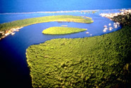 Discovery Coast Atlantic Forest Reserves. (Source: UNESCO)
 The nominated World Heritage Site includes a total area of 111,930 hectares (ha). The site is surrounded by a buffer zone, the area of which has not yet been specified.
Land Tenure
Mixture of public in state and federal protected areas and other sectors of the nominated site, and private.
Altitude
From sea level to 536 meters (m) at the top of Monte Pascoal.
Physical Features
The nominated World Heritage site includes three distinct geomorphologic units, each one corresponding to different geologic phases: (a) Pre-Cambrian metamorphic and magma gneiss outcrops forming round-shaped hills, which are the oldest and highest formations, and are located most distant from the sea. These outcrops are concentrated on the southern part of the area, the most famous being Monte Pascoal; (b) Tertiary sedimentary limestone plateau and tabular hills or "sierras", 100 m in height, which are interrupted by river and stream valleys. The plateau is interrupted near the sea and form a 40 m tall high white or reddish cliffs; and (c) Quaternary mobile sediments and sands from river and sea deposits, which form an irregular coastal stretch of sand plains and paleo-dunes, and accumulate in large river valleys, of which some enter into the sea (e.g. Ponta do Corumbau and Ponta Grande).
River sediments upstream of marine intrusions are made up of stilt gravel and sand. At the river mouths and old lagoons there are deposits of stilt and clay, which are rich in organic matter. Yellow/reddish podzol soils exist on the plateau, whereas in coastal plains they are litholic and sandy. Marine sediments penetrate into the riverbeds up to a long distance from the coast. The main rivers in the nominated site are Jequitinhona, Joao de Tiba, Rio do Frade, Caraiva, Corumbau, Caí and Jucuruçú. They all run westwards and flow into the Atlantic Ocean. Few big rivers originate far from the area in Chapada Diamantina and Espinhaço. Wetlands and seasonally flooded areas exist in large U-shaped river valleys. In general, rivers tend to swell in April and May, due to intense rains. Some streams are saturated with humic acids and show black coloration.
Climate
Brazilian Discovery Coast has a humid tropical climate, which is influenced by South Atlantic oceanic anti-cyclone warm humid winds (southern trade winds) as well as by periodic intrusions of cold winds from the Patagonia anti-cyclone that condense tropical humidity in "frontal rains". Average annual precipitation is 1,500-1,750 millimeters (mm) with two slight minima in August/September and January/February. Dry seasons are more conspicuous inland and away from the oceanic influence. Relative air humidity is around 80% throughout the year. Dominant winds come from the east, being stronger from September to November (spring); in winter, winds are weaker and come from variable directions. Average annual temperature is 22-24°C.
Vegetation
The rainforests of southern Bahia and northern Espirito Santo States (Discovery Coast) are considered as the world's richest in terms of the number of species of trees per hectare. A recent study of CEPLAC and the New York Botanic Garden found 458 different species of trees in one hectare of forest in Bahia. Other surveys identified 476 species/ha in northern Espirito Santo. Until 300 m, the principle vegetation type is highly diverse primary tropical moist broadleaf forest with tall (20-30 m in height) canopy trees. The area contains perhaps the largest number of trees of Pau Brasil Caesalpinia equinata (VU) left on earth. Undergrowth vegetation is rather limited because of poor lighting, but include specimens of jussara palm-tree Euterpe edulis (EN), several species of orchids and lichens. In dryer sectors, piaçaba palm-tree Attalea funifera is frequent and lianas become more abundant. Along the river valleys, there is a gallery forest with jatoba Hymenaea rubriflora, jussara and araça Psidium sp., as well as species typical from surrounding moist forests and areas of restingas. There are areas covered with secondary forests in varying degrees of regeneration. They are rich in epiphytes and parasitic plants and have a dense shrub layer. On sand coastal soils, there is restinga vegetation which, depending on the distance to the shore, includes from humid prairies and shrubs to low forests. Bare sand areas are colonized by very specialized vegetation. Restinga forests contain lianas, orchids and epiphytes. Other types present in the site include seasonally inundated vegetation or "mussunungas", which are endemic to the south of Bahia and north of Espirito Santo; coastal mangroves; and pastures.
Fauna
The fauna is relatively poorly known. Ecological heterogeneity makes precise definition of habitats and local fauna difficult. With the exception of some ecosystems such as wetlands, many organisms are characterized by selecting areas of vegetation gradients and ecotones. Best known groups are birds and primates. Some species present, which are endemic to the Atlantic forest include maned sloth Bradypus torquatus (EN), thin-spined porcupine Chaeotemys subspinosus (EN), jaguar Panthera onca (VU) and Geoffroy's tufted-ear marmoset Callithrix geoffroyi (VU). A rich rodent fauna has been recorded from the region whereas bats from four different families were captured. Diversity of reptiles and amphibians is outstanding; for instance, 60 reptiles and 40 amphibians were collected from the area of Veracruz Station.
Cultural Heritage
The nominated World Heritage Site comprises a series of cultural features, which represent outstanding examples of first European occupation of the New World and a unique testimony of this period in modern history. Some of the most outstanding features are the historic centers of Porto Seguro, Vale Verde, Trancoso and Santa Cruz Cabrália. Numerous archaeological sites, both prehistoric and historic, can be found in the area. The ruins of Brazil's first church lay at the top of a cliff to the north of Porto Seguro. An old Tupi civilization town has recently been unearthed.
There is a population of Pataxó people living in separate indigenous territories, such as Barra Velha (814 inhabitants), Boca da Mata (349), Imbiriba (137), Coroa Vermelha (1,202), Mata Medonha (142), Aguas Belas (65), Corumbauzinho (55) and Trevo do Parque (91). The Pataxó are survivors from the different indigenous cultures that lived in the region.
Local Human Population
Total population in south Bahia State is estimated to be 600,595 people. The municipalities of Porto Seguro (34,661 inhabitants), Santa Cruz Cabrália (6,535), Belmonte (22,070), Itabela (26,904), Itamaraju (44,000), Eunápolis (85,982) and Prado (22,632) lie within the buffer zone. Main economic activities in the region are timber extraction (now stopped by Resolution 240/1998 of the National Environmental Council (CONAMA), cattle ranching, tourism, fruit production and small scale agriculture. The cattle industry is using more than 94% of the land. Cacao production only uses 2.4% of the land in south Bahia, in opposition to the neighboring states to the north, where it used to cover between 40% and 44% of the territory. Main fruit produce is papaya (500,000 tons/year), followed by pumpkin, water melon, coconut, coffee and passion fruit. Monocultures of eucalyptus Eucalyptus spp. are increasing on the plateau. Local industry was dependent on timber and thus now is declining. Other important economic activity is craft fishing along the coast.
Visitors and Visitor Facilities
Available visitation data are from Porto Seguro, which receives average 70,000 visitors per year. Major attractions are beaches and cliffs, offshore coral reef pools, historic monuments, archaeological sites and Monte Pascoal National Park. Tourists are predominantly nationals and from neighboring Argentina. Porto Seguro has 312 hotels and hostages, Cabrália 56, Prado 61 and Belmonte six.
Scientific Research and Facilities
All designated protected areas have some facilities to accommodate visiting scientists. There are also platforms for the collection of specimens from the forest canopy. No detailed information on past or present programs of research was provided.
Conservation Value
The nominated World Heritage Site comprises an outstanding mosaic of terrestrial ecosystems. It also includes an exceptionally high biological diversity with several species of conservation concern. Both existing and proposed conservation units are in excelente state of conservation, and include almost 80% of remaining Atlantic forest that remains in Brazil.
Conservation Management
Federal legislation protects the Atlantic forest in Brazil: Federal Decree No. 750 of 1993 restricts the use or occupation of Atlantic forest vegetation. The extraction, transport and use of Atlantic forest vegetation were completely baned by Resolution 240/1998 of CONAMA. A management plan for Monte Pascoal National Park was prepared in 1979 but was only recently completed by the Emergency Action Plan of 1995. This plan promotes the co-operation with the local industry and is intended to recuperate and improve existing facilities, increase the number of staff and facilitate the integration between local and federal institutions dedicated to activities of research, protection and management. The Pataxó indigenous group and neighboring population are to be actively involved in park's management. The two biological reserves (Sooretama and Una) have management plans under implementation. There is also a directive plan for the Linhares Forest Reserve; this plan has been prepared by the company that owns the property (Companhia Vale do Rio Doce).
Management Constraints
Most of the plateau and hillsides were covered by dense moist broadleaf forest. This are now restricted to the declared and proposed protected areas, and the Bralanda properties in Prado and Porto Seguro. The areas between these forest patches are mainly pasture and cultivated land, with scattered wood lots and gallery forests along the watercourses. The Federal Government is fighting land invasion by rural workers by settling them in non-productive areas thus increasing deforestation.
Staff
Monte Pascoal National Park has a staff of six people, of which one is technical, two are forest agents, two are administrative and one is radio operator. Veracruz Station has a staff of nine people, of which one is technical, one administrative, three are forest agents and four tourist guides. CEPLAC Pau Brasil Station has a personnel (planned) of six people, of whom one is the director, three forest agents, one administrative and one radio operator. Una Biological Reserve has a staff of seven people, of which six are rangers and one administrative. Sooretama has a staff of 23 people, of which one is the director, one secretary, 20 guards and one driver. Linhares Forest Reserve has a total staff of 12 people.
Budget
Varies from protected area to protected area. The 1998's budget of Monte Pascoal National Park was US$156,000, whereas those of Veracruz Station were US$180,000 and US$60,000.
IUCN Management Category
- Una Biological Reserve la (Strict Nature Reserve)
- Pau Brasil CEPLAC Experimental Station la (Ecological Station)
- Sooretama Biological Reserve la (Ecological Station)
- Monte Pascoal National Park II (National Park)
- Pau Brasil National Park II (National Park)
- Descorbimento National Park II (National Park)
- Veracruz Station Private Natural Heritage Reserve la (Private Reserve)
- Linhares Forest Reserve la (Private Reserve)
- Natural World Heritage Site - Criteria ii, iv
Further Reading
The most relevant references included in the nomination are the following:
- Brasil 1989. Unidades de Conservaçao do Brasil, vol. 1: Parques Nacionais e Reservas Biológicas. IBAMA, Ministerio do Interior, Brasilia. 182 pp.
- Companhia Vale do Rio Doce (1999). Plano Diretor de Uso da Reserva Florestal de Linhares. 54 pp.
- MMA, IBAMA and MinC (1998). Presentation of the Brazilian Discovery Coast as natural and cultural property to be nominated for inscription to the World Heritage List 1998. 44 pp.
- MMA/IBAMA (1997). Reserva Biológica de Una (Plano de Manejo). 61 pp.
- Etchevarne, C., Motta, L.B. and Nascimento, L.V. (1998). Mapeamiento de sitios arqueológicos da Costa do Descrubrimiento (Municipios de Porto Seguro e Santa Cruz Cabrália). Relato, Universidade Federal da Bahia, Museu de Archeologia e Etnologia. 5 pp.
- Hetzel, B., Barreira, C. and Castro, E. (1994). Corais do sul da Bahia. ZMAN Leao colaboradores, Nova Fronteira, Rio de Janeiro. 189 pp.
- IBAMA (1995). Plano de açao emergencial para o Parque Nacional de Monte Pascoal. Documento Final. A. Pantoja Consultora, Petrobrás, DIREC, Brasilia. 37 pp.
- IBAMA (1999). Presentation of the Brazilian Discovery Coast as Natural Property to be nominated for inscription to the World Heritage List. 26 pp.
- IBAMA (1999). Plano Básico de Implantaçao do Parque Nacional do Pau Brasil. 7 pp.
- IBAMA (1999). Plano Básico de Implantaçao do Parque Nacional do Descobrimento. 7 pp.
- IBDF 1979. Plano de manejo do Parque Nacional de Monte Pascoal. Brasilia. 155 pp.
- IBDF 1981. Plano de Manejo do Reserva Biológica de Sooretama. 69 pp.
- IUCN (1996). 1996 IUCN Red List of Threatened Animals. IUCN, Gland, Switzerland. 368 pp. + annexes. ISBN: 2831703352.
- Mori, S.A. and Prance, G.T. (1981). Distribution pattern and conservation of eastern Brazilian coastal forest tree species. Brittonia 33:233-245.
- Thomaz, L.D. and Monteiro, R. (1997). Composiçao florística da Mata Atlântica de encosta da Estaçao Biológica de Santa Lúcia, município de Santa Teresa - ES. Boletim do Museu de Biologia Mello Leitao 7:3-48.
| Disclaimer: This article is taken wholly from, or contains information that was originally published by, the United Nations Environment Programme-World Conservation Monitoring Centre (UNEP-WCMC). Topic editors and authors for the Encyclopedia of Earth may have edited its content or added new information. The use of information from the United Nations Environment Programme-World Conservation Monitoring Centre (UNEP-WCMC) should not be construed as support for or endorsement by that organization for any new information added by EoE personnel, or for any editing of the original content. |