Coral bleaching, satellite observations, and coral reef protection
Contents
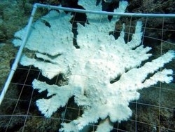
- 1 Introduction Bleached elkhorn coral near St. Croix, USVI, in October 2005. (Source: NOAA Center for Coastal Monitoring and Assessment (Coral bleaching, satellite observations, and coral reef protection) )
- 2 What is Coral Bleaching?
- 3 NOAA Satellites and Sea Surface Temperature
- 4 Monitoring for Coral Bleaching Conditions
- 5 What Can We Do To Protect Coral Reefs?
- 6 Relevant Web Sites
- 7 Further Reading
Introduction Bleached elkhorn coral near St. Croix, USVI, in October 2005. (Source: NOAA Center for Coastal Monitoring and Assessment (Coral bleaching, satellite observations, and coral reef protection) )
The U.S. National Oceanic and Atmospheric Administration (NOAA) uses satellite data to pinpoint areas around the world where corals are presently at risk for bleaching. This article gives a brief background on coral bleaching, and then introduces some satellite tools used to assess bleaching risk in near-real-time.
August is the start of the coral bleaching season in the Caribbean. Average water temperatures reach a maximum in August and September, putting corals at risk. August 2005 saw the beginning of a record-breaking coral bleaching event throughout the Caribbean region, from Belize to the Bahamas and from Tobago to Texas. The U.S. Virgin Islands were hit particularly hard: up to 95 percent of the corals bleached, and some areas saw 50 percent of the coral area killed — an astonishing loss in just a few months.
What is Coral Bleaching?
Mass coral bleaching events like this are caused by unusually high water temperatures and high light that stress corals.
Corals have symbiotic algae, called zooxanthellae, living within their body tissues. The algae provide food and oxygen for the coral, and the algae get the benefit of nutrients and a safe growing environment in return. When corals are stressed, they expel the zooxanthellae. The algae give corals their distinctive colors, so when the coral loses their algae all you see is the white skeleton through the clear coral tissue — thus, the coral appears “bleached.”
Corals can recover from mild bleaching, gradually recovering their color by repopulating their algae. However, if the bleaching is severe or prolonged, individual polyps or whole colonies will die.
Reef-building corals require warm, tropical water — but how warm is too warm? Scientists have discovered that corals become stressed if the water is only one degree Celsius above the average temperature for the warmest month of the year. This temperature is known as the “bleaching threshold.”
If the temperatures don’t get too high or last too long, the corals can recover. They gradually rebuild their stock of zooxanthellae, and will likely go on to live healthy lives. However, if the temperature rises significantly above the bleaching threshold or remains high for several weeks, severe bleaching will occur. Corals that are left without their main food source and are subjected to damage from sunlight can eventually die. Those that do survive are more subject to disease outbreaks, just like a stressed person is more likely to fall ill. These diseases can also kill corals, months after the bleaching occurs.
NOAA Satellites and Sea Surface Temperature
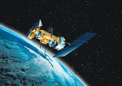 Artist’s rendering of a NOAA polar-orbiting satellite. (Source: NOAA)
 The connection might not be immediately obvious, but NOAA’s polar-orbiting satellites that circle the Earth are a crucial tool in combating coral bleaching. How can a satellite that orbits 850 kilometers (530 miles) above the Earth help the coral colonies that grow meters below the ocean surface?
NOAA operates a system of environmental satellites that orbit around the Earth, passing close to the north and south poles on each orbit many times a day: these are called polar-orbiting satellites (POES). Although they can only measure a given area a few times each day, they are able to take measurements around the entire planet. NOAA’s Coral Reef Watch uses the POES satellites to monitor oceanic conditions around the world, every day.
These satellites carry carefully calibrated, sensitive instruments that measure infrared radiation. They are basically “feeling” the heat that radiates from the ocean surface, producing maps of sea surface temperatures (SST). The instrument used by Coral Reef Watch is called Advanced Very High Resolution Radiometer (AVHRR). For more information about this “radiometer” sensor and how it measures ocean temperature see: NOAA's description of the AVHRR instrument and University of Wisconsin tutorial on infrared imagery.
Monitoring for Coral Bleaching Conditions
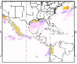
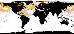 Coral bleaching HotSpots from August 27, 2005. Yellow to orange colors indicate areas above the bleaching threshold. Note the warm waters around the entire Caribbean region. (Source: NOAA)
 NOAA Coral Reef Watch customizes products from these satellite temperature readings to look for areas at risk for coral bleaching. The key is to focus in on regions where the SST is higher than normal — especially where it’s warmer than the mean temperature during the hottest month of the year. For example, consider Sombrero Reef in the Florida Keys: the mean water temperature reaches its maximum value in August and September, peaking at around 29°C (84°F). The NOAA Coral Reef Watch program monitors this site to see if the SST goes above 29°C, creating what is known as a HotSpot. When this same methodology is applied to all global satellite SST measurements, it produces a global map of coral bleaching HotSpots.
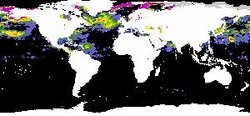 Degree Heating Weeks from August 27, 2005, at the beginning of the bleaching event. Green to red indicates where heat stress has accumulated, and corals are at risk for severe bleaching. (Source: NOAA)
 HotSpots are just the first step in pinpointing areas at risk for bleaching. High temperatures are important, but stress builds up if corals are exposed to high temperatures for weeks at a time. Thus, another important factor that the NOAA Coral Reef Watch program measures is the “cumulative thermal stress” the corals have been exposed to over the past three months —known as Degree Heating Weeks. DHWs are a combined measurement of how high the HotSpots have been, and how long they have lasted. If DHWs rise above four, coral bleaching is expected; values above eight indicate that mass bleaching and some coral mortality is likely. The situation in the Caribbean was so bad in 2005 that some areas reached DHWs over 16 — four times the level of stress needed to cause coral bleaching — resulting in widespread coral bleaching and death in 2005.
The latest tool in the Coral Reef Watch suite of operational data products are the Satellite Bleaching Alerts. For select locations around the world, reef managers and researchers, and even public users, can sign up for free automatic e-mail alerts. The e-mails warn subscribers when ocean temperatures rise to dangerous levels and corals may be at risk.
 Latest HotSpot image for the Caribbean region, updated twice-weekly. (Source: NOAA)
The data products that the NOAA Coral Reef Watch program produces are applicable to a wide range of users: coral reef researchers, climate scientists, managers of coral reef parks and reserves, students and the interested public. Therefore, it is important to provide the data in a variety of different formats to meet the varying needs. Images have always been the most popular format, since they are so widely used, but the NOAA Coral Reef Watch program also offers the raw data, so that a more technical audience can process the data to meet their own individual needs. Recently, NOAA also started making the data available to Google Earth users — providing a flexible and educational new way to see where reefs are currently at risk from coral bleaching.
What Can We Do To Protect Coral Reefs?
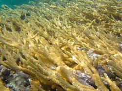 Healthy Acropora prolifera coral, photographed near Lee Stocking Island, Bahamas, February 2005. Image from Mark Eakin, Coral Reef Watch)
 Talking about coral bleaching naturally raises the question — can anything be done to prevent bleaching or to help corals recover? NOAA (in partnership with the Great Barrier Reef Marine Park Authority, the World Conservation Union, The Nature Conservancy, and others) has developed some guidelines to help marine park managers protect their corals from the long-term effects of coral bleaching. There are some mitigation measures that might help:
- Restrict potentially stressful activities (such as diver access, fishing, or nearby construction) during and after a bleaching event
- artificially shade or cool selected reefs to lessen the bleaching impacts
- remove coral predators from the area, to allow corals to recover
- remove obvious coral disease to prevent it from spreading
- enhance the overall health of the corals by reducing pollution, coastal runoff and overfishing—a healthy reef ecosystem is more able to recover
In addition, there are some areas that may be naturally protected from the conditions that cause bleaching or where corals have adapted to the stressful conditions. It is especially critical to identify and protect these areas.
Researchers are still learning about the danger of bleaching events to [[coral reef]s]. NOAA will continue to work with colleagues around the world to monitor coral reefs and their surrounding environment (both from space and in the ocean) during and after bleaching events, to learn more about the causes and consequences of coral bleaching. This knowledge will be critical for the long-term survival of the world’s beautiful and valuable coral reefs.
Relevant Web Sites
- NOAA Coral Reef Watch homepage
- Education materials from NOAA Coral Reef Watch: tutorial, grade-school curriculum, etc.
- More about the 2005 Caribbean bleaching event
- NOAA CCMA Biogeography Program’s report on the 2005 Caribbean bleaching in St. Croix, US Virgin Islands
- Visit the Coral Reef Conservation Program to learn about all of NOAA’s coral reef activities
- Data and publications from all of NOAA’s coral reef activities are available through the Coral Reef Information System.
- Read more about coral bleaching and coral diseases from the NOAA Coral Reef Information System.
Further Reading
- Elvidge, C.D., J.B. Dietz, R. Berkelmans, S. Andréfouët, W. Skirving, A.E. Strong and B.T. Tuttle (2004). Satellite observation of Keppel Islands (Great Barrier Reef) 2002 coral bleaching using IKONOS data. Coral Reefs 23(3): 461-462.
- Glynn, P. W. and L. D’Croz, 1990. Experimental evidence for high temperature stress as the cause of El Niño coincident coral mortality. Coral Reefs, 8, 181-191.
- Goreau, T. J. and R. Hayes, 1994. Coral bleaching and ocean "hot spots." Ambio, 23:176-180.
- Heron, S.F., E.J. Metzger and W.J. Skirving (2006c). Seasonal Variations of the Ocean Surface Circulation in the Vicinity of Palau. Journal of Oceanography 62(4): 413-426.
- Liu, G., A.E. Strong, W.J. Skirving and L.F. Arzayus (2006). Overview of NOAA Coral Reef Watch Program’s Near-Real-Time Satellite Global Coral Bleaching Monitoring Activities. Proceedings of the 10th International Coral Reef Symposium, Okinawa: 1783-1793.
- Liu, G., A.E. Strong and W. Skirving (2003b). Remote Sensing of Sea Surface Temperatures during 2002 Barrier Reef Coral Bleaching. EOS, Transactions of the American Geophysical Union 84(15): 137.
- Strong, A. E., F. Arzayus, W. Skirving, and S. F. Heron. Identifying coral bleaching remotely via Coral Reef Watch – improved integration and implications for climate change. Chapter 9 in Coral Reefs and Climate Change: Science and Management, J. T. Phinney, O. Hoegh-Guldberg, J. Kleypas, W. Skirving, and A. E. Strong (Co-Eds), American Geophysical Union, 2006. ISBN: 0875903592.