Coal fires
| Topics: |
Geology (main)
|
Contents
Definition of coal fires
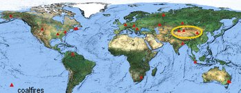
The term coal fire refers to a burning or smoldering coal seam, coal storage pile or coal waste pile. The adsorption of oxygen at the outer and inner surface of coal and resulting oxidation is an exothermic reaction. This leads to an increase in temperature within the coal accumulation. If the temperature exceeds approximately 80°C the coal can ignite and start to burn. This process, referred to as “spontaneous combustion”, is the most common cause for coal fires of large extent. Spontaneous combustion processes can be accelerated through human impact. Mining operations expose formerly covered coal to oxidation processes and additionally lead to the accumulation of large coal waste and storage piles. Coal fires can also be ignited by lightning, forest- or peat fires, mining accidents or careless human interaction. Uncontrolled coal seam fires are an environmental and economic problem of international magnitude. They occur in many countries worldwide including China (Energy profile of China), India (Energy profile of India), Russia (Energy profile of Russia), the United States (Energy profile of the United States), Indonesia (Energy profile of Indonesia), Venezuela (Energy profile of Venezuela), Australia (Energy profile of Australia) and South Africa, but also at a smaller scale for example in Germany (Energy profile of Germany), Romania or the Czech Republic.
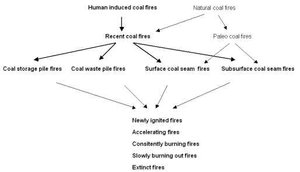
Depending on cause, location, age and burning intensity, coal fires can be classified into different types. Coal fires can be human induced, when coal seams in areas of mining activity start to smolder or burn due to anthropogenic causes. They can occur naturally, when the fire is a result of natural spontaneous combustion. Furthermore, underground and surface coal fires, cold and hot coal fires, paleo- and recent coal fires, as well as coal fires in coal seams, coal waste- or coal storage piles can be differentiated. Others additionally classify shallow (0-10 meters [m]), intermediate (10-30m) and deep fires (>30m), depending on their location underground. The oldest documented coal fire on a global scale, which has been burning for over 2,000 years, is located in New South Wales, Australia. Another case that has attracted strong public attention is the subsurface coal fire in Centralia, Pennsylvania, U.S., which started in 1962. Here, between 1980 and 1998 a whole city had to be evacuated and relocated. The slowly advancing coal fire underneath the city endangered houses and infrastructure. Even today the fire still leads to the collapse of formerly inhabited ground.
In China (Energy profile of China), coal fires are mentioned in historic documents as early as 1000 AC in the travel report of Li Dao Yuan, who explored Northwest China during the “Northern Song Dynasty” (960-1280 AC). Also the travel documents of Marco Polo (1254-1324 BC) mention the “burning mountains along the silk road” as well as paleo coal fires in Xinjiang, which are dated back to be of Pleistocene age. Today, China is the leading country concerning coal production, consumption and export, whereas Russia (Energy profile of Russia) and the U.S. rank first and second in terms of coal reserves on a global scale. Annual Chinese coal production averages above 1500 million tons. The energy supply for approximately 1.3 billion Chinese people, of which over 25% live in cities, is mainly provided by coal. Oil accounts for only 20% of the total energy supply. Only two nuclear power plants exist and gas production is negligible. Next to coal, only hydroelectric power is of higher relevance, showing increasing growth rates in Southwest China. Therefore, the country at present accounts for 28% of the world’s coal use with projected requirements of 1632 million tons coal equivalent in 2010 and faces the problem of numerous uncontrolled burning coal fires.
Coal fires in China
Today, the main coal fire areas stretch along the coal mining belt in China (Energy profile of China), which extends for 5000 kilometers (km) from east to west along the north of the country. Here more than 50 coal fields affected by coal fires have been identified. At present in China an estimated 20-30 million tons of coal burn each year. This corresponds to the amount of Germany’s annual hard coal production. Actually, the tenfold amount of the resource is lost, since coal adjacent to a coal fire becomes inaccessible. The economic loss of the valuable resource in China is estimated to sum up to total 4.2 billion tons since 1960. Thus, China faces the world’s biggest problem of coal fires both in terms of the spatial area affected and the amount of coal lost each year.
Besides the economic loss, coal fires pose many environmental threats. The fires produce large amounts of greenhouse-relevant and partially toxic gases including carbon dioxide (CO2), methane (CH4), nitrogen oxides (NOx), nitrous oxide (N2O), carbon monoxide (CO) and sulfur dioxide (SO2). According to most recent estimations coal fires in China contribute about 0.1% to 0.2% of the annual human induced CO2 emissions globally. They contribute 12% of all Chinese coal-based carbon emissions in the form of CO2. In addition, coal fires lead to the degradation of their direct surrounding area through significant aerosol input to water sources and agricultural areas. Additionally, the toxic fumes released pose a threat to the health of the local inhabitants. Furthermore, land subsidence can occur due to the loss of volume underground, when a coal seam, supporting several layers of overlying strata, turns into ash. The resulting slow or very sudden subsidence can be a threat to infrastructure, local inhabitants and miners. Each year, several thousand workers are killed in mining accidents, which are quite often also coal fire related.
These negative environmental impacts of coal fires explain the urgent need for methodologies to map, analyze and monitor the coal fire regions. Since many Chinese (Energy profile of China) mining regions are located in remote areas, airborne or satellite remote sensing can play a key role for coal fire detection and monitoring. With respect to the large spatial extent of the Chinese coal mining belt and the number of existing coal fire areas, remote sensing is a powerful tool for the generation of land cover- and coal fire maps. Reflective and thermal indicators can be derived from satellite data to develop early warning- or risk assessment strategies and to implement priority schemes for future coal fire extinguishing activities.
Remote Sensing of Coal Fires
Documented coal fire research based on remote sensing data started around 1963, when a company producing airborne thermal cameras tested their equipment above burning coal waste piles in Scranton, Pennsylvania. The thermal imagery clearly showed the burning areas within the coal waste piles as light grey values. Further aerial surveys with thermal cameras in the 1960s and 1970s were conducted by numerous American authors. Their main research foci were investigations of coal fires in the U.S. at a very local scale. These approaches were dominated by visual interpretation and the localization of the well-known fires within the imagery. Density slicing was used exclusively to extract the fires from the image data.
In the early 1980s coal fires were already studied in several countries. Still aerial remote sensing was the main tool applied. In 1983 multi-spectral scanner data and thermal infrared scanner data was used for the investigation of coal fires in the Chinese regions of Taiyuan Xishan in Shanxi province. Coal fire research based on aerial multispectral scanner data continued in India, where several researchers investigated the Jharia coal field, generating coal fire maps derived from the aerial thermal data based on ground truth knowledge. Satellite data based research was mainly focusing on the sensors NOAA AVHRR and Landsat-5 TM thermal band data with 120-meter (m) spatial resolution in the thermal band, which proved sufficient for the detection of surface fires but often proved too coarse to detect very deep or small coal fires.
Overall, studies applying the thermal Landsat-5 TM band 6 were mainly limited to the exact demarcation of hot and large surface coal fires and the rough localization of hot or large underground coal fires supported by field measurements. Research undertaken included the application of this satellite data to different locations, the evaluation of density slicing techniques for coal fire detection, and temperature retrieval in case of coal fires exceeding several pixels in size. Furthermore, time series analyses were pursued to describe the movement of the fires. First relief-based thermal calibration methods, differencing methods between thermal daytime and nighttime data and the combined interpretation of the two were employed. In addition, combining the information of Landsat band 6 with band 5 and 7 (1.55-1.75 micrometers [µm] and 2.08-2.35 µm) was tested. Based on the ‘dual band method’ developed, the size and temperature of very hot surface coal fires occupying sub-pixel portions could be calculated.
Generally, satellite data with a coarser spatial resolution than that of Landsat-TM was rarely used for coal fire research. The spatial resolution of NOAA-AVHRR data (1 kilometer [km]) in general is too low to detect underground coal fires. The same applies to un-enhanced 1km resolution data from MODIS. However, with MODIS data now available as daytime data from the platform TERRA and as very valuable pre-dawn data from the platform AQUA (and data available up to five times a day) the extraction of thermal anomalies resulting from surface coal fires is unsuccessful. Ratio images from MODIS thermal nighttime data were successfully used for the detection.
The above mentioned remote sensing research had a focus on very interactive analyses, where coal fire thermal anomalies were extracted using density slicing and thresholding. Spatially transferable or automated methods did not exist. Coal fire research based on multispectral reflective remote sensing information has only been conducted in rare cases, focusing on local descriptions of coal fire area environments. In the past five years three approaches were developed all aiming at large scale transferable analyses, which enable country-wide monitoring of coal fires. These are the automated demarcation of coal fire risk areas in multispectral satellite data, the automated detection of subtle thermal anomalies in thermal satellite data and the quantification of these detected anomalies.


