Central Suriname Nature Reserve, Suriname
Contents
- 1 Geographical Location
- 2 Date and History of Establishment
- 3 Area
- 4 Land
- 5 Altitude
- 6 Physical Features
- 7 Climate
- 8 Vegetation
- 9 Fauna
- 10 Cultural Heritage
- 11 Local Human Population
- 12 Visitors and Visitor Activities
- 13 Scientific Research and Facilities
- 14 Conservation Value
- 15 Conservation Management
- 16 IUCN Management Category
- 17 Further Reading
Geographical Location
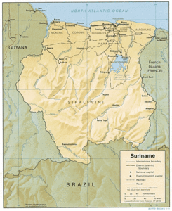
The Central Suriname Nature Reserve (CSNR) is a World Heritage Site located in central Suriname, 200 kilometers (km) south west of Paramaribo, in the District of Sipaliwini. Geographical co-ordinates for the site are: 4ºN 56º W.
Date and History of Establishment
CSNR was designated on July 31, 1998 and is legally protected, under the country’s Nature Protection Act of 1954. The reserve forms a corridor linking 3 former protected areas: Raleighvallen Nature Reserve (78,000 hectares (ha)), Eilerts de Haan Gebergte Nature Reserve (220,000 ha) and Tafelberg (Table mountain) Nature Reserve (140,000 ha). These pre-existing reserves (that are now IUCN category II), were designated by State Resolution on April 22, 1966.
Area
1,600,000 ha.
Land
 Suriname, South America. (Source: University of Texas)
 State-owned.
Altitude
Ranges from 25 meters (m) to 1,23 0m (the summit of Juliana Top, Suriname’s highest peak).
Physical Features
Suriname is part of the Guayana Shield a two billion-year-old Pre-Cambrian formation that stretches over eastern Venezuela, Guayana, Suriname and northern Brazil. The nominated site constitutes a major and representative proportion of this physical feature. Lying between the Amazonian and Orinoco river basins, it is a complex massif of hard, predominantly proterozoic rock-formations, with low mineral content.
Additionally, several unique geological and physical formations occur in the nominated site including several granite inselbergs, granitic outcroppings that rise out of the surrounding tropical forest. These dome-shaped formations were created during the Tertiary and Pleistocene periods, and have steep or vertical sides and little or no vegetation on their summits. The most famous inselberg in the CSNR is the Voltzberg Dome (250 m above sea level). The 360 m high Van Stockemberg formation, is another example of a well-known inselberg in the reserve. Such formations often posses unique vegetation, that differs from that of the surrounding forest. A unique geological feature in the CSNR, is the Devil’s Egg, a giant boulder balanced on top of a granite spire, that is several hundred meters high.
The CSNR encompasses the upstream watershed of the Coppename River, one of Suriname’s largest rivers and the third largest watershed in the country; as well as a portion of the headwaters of the Curuni River and several other headwaters. Significant tributaries of the Coppename include the Rechter-Coppename River, the Midden-Coppename River, the Linker-Coppename River, Adampada creek and Tanjimama Creek. Waterfalls and rapids, are features that are also included in the nominated site. The "sulu complex" near Foengoe Island is of particular significance. It is a 2 km long stretch of river rapids just south of the island, that are essentially non-navigable.
Tepuis (flat topped mountains), are present on the site, particularly in the former Tafelberg Nature Reserve. This reserve includes the most easterly tepui in South America. In the southern portion of the CSNR, lies the Wilhelmina Mountain range, the location of Surnime’s highest peak, Juliana Top (1,230 m).
Climate
Suriname has a typical tropical climate, with a mean daily temperature of about 27ºC and an annual range of only 2ºC. Annual rainfall varies between 1750 and 3000 millimeters (mm), and a generally high humidity prevails throughout the year. There are two rainy seasons, one from approximately mid-April to mid-August and one from December to January (less significant). Dry seasons occur between these two periods. These climatic conditions contribute significantly to the high weathering rates that occur in the region.
Vegetation
Four broad ecological zones are identified in Suriname: the young coastal plain, the old coastal plain, the savanna belt and the interior. The Central Suriname Nature Reserve lies in the interior of the country (three-quarters of Suriname is in this zone), and displays a variety of natural habitats and a rich flora.
Despite relatively nutrient-poor soils, the CSNR is dominated by pristine primary, lowland and montane, tropical rain forest, representing one of the largest tracts of undisturbed, uninhabited and unhunted primary forest in the tropics. Small fragments of marsh forest exist along rivers and creeks, and there are also areas of isolated savanna. The floral diversity of the area is mostly as a result of region’s humid climate. Due to the size of the reserve and its inaccessibility, a detailed inventory of the vegetation occurring throughout the site has yet to be conducted. Information is, however, available for some of the pre-existing reserves that constitute the CSNR, and it is expected that this is representative of much of the reserve.
The former Raleighvallen Nature Reserve contains the majority of the forest systems present in the CSNR. Moist mesophytic forest predominates, although swamp forest, marsh forest, liane forest, savanna forest and mountain savanna forest is distinguished. The canopy of mesophytic forest typically extends to a height of 30 m, although in some instances this increases to 40-50 m. Examples of tree species occurring in the canopies includes: kankantri (Ceiba penandra) and ingipipa (Couratari spp.). Palms constitute much of the understorey, including paramacca (Astrocaryum), kumbumacca (Oenoecarpus bacaba) and maripa (Maximiliana maripa), with ferns and moss-ferns found on the forest floor.
A unique ecosystem occurring in the reserve is the Roraima sandstone savanna, the only one of its type in Suriname. This savanna, known as Rudi Kappel savanna, extends over an area of 1,000 ha, and is situated at an elevation of 300 m. The vegetation of the inselbergs is also unique, as significantly differs from that of the surrounding forest. Xerophytic vegetation occurs on and around the granite outcrops, consisting predominantly of plants from Bromelia, Poaceae and Orchidacea families. Epilitic (growing on stones or [[rock]s]) species of orchids are also often found. To date nearly 6,000 vascular plant species have been collected from the CSNR, with five endemic plant species occurring on the Voltzberg Dome, and 42 endemic species collected from other areas of the reserve.
Fauna
 Suriname, South America. (Source: University of Wisconsin-Madison)
 Suriname is a territory that is rich in fauna. Within the country 680 bird species, 185 mammal species, 152 species of reptiles, 95 species of amphibians and 790 fish species have been recorded. A total of approximately 1,890 vertebrate species are known to exist in the country, 3 percent of which are endemic to Suriname. It is believed that a significant proportion of these species, are present in the nominated World Heritage site.
The CSNR is known to contain more than 400 of Suriname's known bird species, including Scarlet, Red-and-Green and Blue-and-Gold Macaws, (Ara macao, Ara chloroptera, Ara ararauna); Great Tinamou (Tinamus major), Black Curassow (Crax alector) the Guianan Cock-of-the-Rock (Rupicola rupicola) and the Harpy Eagle. The northern section of the CSNR is known globally as one of the best places to see Red and Green Macaws (Ara chloroptera) and the Guianan Cock-of-the-Rock (Rupicola rupicola).
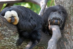
The Reserve is also home to all eight species of Suriname's monkey, representing seven genera and two families. These include the White-faced Saki (Pithecia pithecia) and the common squirrel monkey (Saimiri sciureus) red howler monkey (Alouatta senculus), black spider monkey (Ateles paniscus), red-handed tamarin (Saguinus midas), brown capuchin (Cebus apella) the weeper capuchin (Cebus nigrivittatus) and the black saki (Chiropotes satanas).
Viable populations of the Jaguar Panthera onca (Lr), the Giant Armadillo Myrmecophaga tridactyla (EN) and the Giant River Otter Pteronura brasiliensis (VU) also exist in the nominated site. Other animals that have been recorded include the two-toed sloth Choloepus didactylus, the three-toed sloth Bradypus tridactylus, puma Felis concolor and the tapir Tapirus terrestris.
Much of the Reserve has yet to be explored, thus the true extent of the nominated site’s diversity is not fully known. Faunal checklists are available in STINASU offices in Paramaribo.
Cultural Heritage
Cultural artifacts have been found in the area surrounding the Coppename River, in the Raleighvallen area, indicting that the site was inhabited during pre-Colombian times. Archaeological material from ancestors of the Carib indians has been found near the junction of the Linker-Coppename River, while petroglyphs have been found along a small creek near the Voltberg Dome. The Kwinti Tribe are believed to have settled along the Coppename river in the 17th Century. It is considered that there is likely to be additional archaeological material in the reserve, that may be potentially significant to Suriname’s cultural heritage.
Local Human Population
Although there are no permanent human settlements or inhabitants within the nominated site, there are three communities located nearby that may be affected by the creation of the CSNR. These are the Kwinti Maroon communities of Witagron and Kaaimanston who reside 60 km north of the CSNR, alongside the Coppemame River and the Trio indigenous community of Kwamalaamutu, who reside 100 km to the south of the CSNR border. Members of the Witagron and Kaaimanston communites have acted as guards, porters and guides for visitors and researches at the pre-existing Raleighvallen Nature Reserve.
Visitors and Visitor Activities
Access to the reserve is by river and road (to Raleighvallen only), or by air. Traveling to Raleighvallen by road and river is the usual method of reaching the reserve. Visitors must travel approximately 185 km south to Bitagron from Paramaribo. Upon reaching Bitagron, a 4-5 hour boat trip up the Coppename River to Foengo Island brings travelers to the reserve’s headquarters. There are three airstrips in the reserve.
There are less than 1,000 recorded annual visitors to the CSNR, the majority of whom are foreign. Aracari Tours a nature tour/ecotourism operator, runs tours to the top of the Voltzberg Dome. On average four to six four-day tours (totaling 40 guests), take place during the dry season. Other visitors include researchers, scientists and independent adventure travelers.
Overnight accommodation facilities exist at Raleighvallen which include two guesthouses on Foengoe Island close to the airstrip, and one research/guest facility owned by the Forest Service. Several hiking trails exist in Raleighvallen Nature Reserve, linking Foengoe Island to the airstrip and several locations of interest, such as the Voltzberg Dome. STINASU is responsible for the upkeep of the facilities at Raleighvallen and for promoting tourism to the area. There are plans for the construction of additional visitor facilities at Raleighvallen, although as yet these are not clearly defined.
A recently refurbished guesthouse exists at Rudi Kappel airstrip in the Tafelberg area. Three lodges and additional tour facilities are located at the southern airstrip of Kayser. During the dry season about four groups are accommodated in these facilities (at Kayser). These lodges are managed by The Foundation the Friends of Kayser.
There are several developments planned for the future that aim to address visitor needs. The community-based "Foundation for the Resettlement of Witagron and Kaaimanston", plans to develop facilities to transport visitors to the CSNR by boat. These project activities are to be funded through the UNDP/GEF Small Grants Programme. A guard station is planned at Witagron, and two satellite stations are proposed for two of the adjacent creeks. The Witagron station will also serve as a visitor center and ‘craft store’ for tourists traveling in the region.
Scientific Research and Facilities
The site’s inaccessibility has limited the research that has been possible in the area. Most biological research has taken place within the three originally existing reserves that constitute CSNR. The Raleighvallen area has been utilized for scientific study for many years, and of the three pre-existing protected areas, it has been the main focus for most scientific research. The geology and geography of Raleighvallen was first described by Martin (1888) and Bakhuis (1902). Since that time botanical and zoological fieldwork by researchers from around the world, has continued to occur. Botanical fieldwork has studied tropical rainforest ecology, vegetation survey and forest fruits. Completed zoological studies include work on monkeys, night-jars, reptiles, and Cock-of-the-Rock. In recent years much of the research throughout the reserves has focused upon larger animals such as caimans, primates and Cock-of–the-Rock. Conservation International has recently constructed a research station at the base of Voltzberg Dome and the University of Florida operates a primate research station near Raleighvallen.
Conservation Value
The Central Suriname Nature Reserve represents an example of undisturbed tropical rain forest incorporating three existing protected areas. Suriname is globally and regionally significant in terms of the extent of its tropical forest cover. Approximately 90% of the country’s total area is forested, more forest cover than that in all of Central America; thus it is one of the most forested countries in the world. The huge area of the CSNR (approximately the size of the state of New Jersey, USA) ensures that one of the most biologically diverse areas of the world is maintained.
As the site is uninhabited and has had little disturbance from humans, it provides a valuable baseline for biological and ecological research useful for the conservation of other tropical [[ecosystem]s], and has plant gene-pool benefits. The presence of geological features (inselbergs), is also of great conservation value.
Conservation Management
Nature conservation and reserve management in Suriname, is the responsibility of the Nature Conservation Division of the Forest Service (LBB). At present the only management plan that exists for the site, relates to the former Raleighvallen Nature Reserve portion. This was compiled by WWF in 1993, and is implemented with the assistance of The Foundation for Nature Preservation (STINASU). A management plan and an ecotourism plan for the whole of the CSNR is currently being developed. Due to the site’s inaccessibility, a de facto buffer zone of 100 km width exists around the reserve.
At a national level, a "Conservation Action Plan for Suriname" was published in 1990. This was later complemented in 1994 by the publication " Priority Conservation Activities for Suriname". Sixteen priority initiatives were outlined, including the preparation and implementation of management plans for nature reserves, the training of conservationists, nature conservation education, research on threatened species and the enforcement of nature conservation legislation. A Concept National Environmental Action Plan (NEAP) was drafted in 1996 by the University of Suriname’s Institute for Development, Planning and Management.
The ecotourism plan currently being prepared for the CSNR will aim to promote sustainable ecotourism within the protected area, as part of a central component of tourism infrastructure establishment, policy development and promotion. Management activities will focus on the airstrips.
Management Constraints
Due to the nominated site’s large size and inaccessibility, threats to the CSNR are insignificant. However with the promotion of the site and increased future development, threats could potentially arise.
Pressures that do threaten the site primarily stem from concession activities. Several large-scale mining and logging concessions exist or are being awarded close to the boundaries of the nominated site. Several mining companies are prospecting for gold to the north of Raleighvallen, in the northern portion of the CSNR. Additionally large bauxite deposits have recently been discovered to the west of the reserve, while several exploratory timber concessions are located to the north and east. While these concessions mainly exist outside the boundaries of the CSNR and its watershed, vigilance will be required to ensure future developments or associated increased human activities do not threaten or damage fragile and pristine [[ecosystem]s] within the reserve. Reserve boundaries are not yet marked in the CSNR, thus heightening the need to ensure prohibited or illegal mining or harvesting activities do not occur within the protected area.
Staff
Current staffing levels within the CSNR are relatively low, primarily being due to the site’s isolation. At present a Reserve Manager and 3-4 guards/field workers are employed at Raleighvallen Nature reserve. Gum Air and Aracari Tours take tourists to Tafelberg, where 2 caretaker/managers are employed. There are no permanent staff or guard stations at Eilerts de Haan.
Within the outline for the future CSNR management plan, the need for guard posts at all access points to the reserve has been specified. Three locations around Raleighvallen Nature Reserve have been identified; guard posts are also planned for the 3 airstrips in the reserve.
Budget
The Government of the Republic of Suriname does not currently provide a budget for the management of the site. Future management funds necessary to complete and implement the management plan for the CSNR, as well as long-term financing to support the Reserve’s management is to be provided by the Suriname Conservation Trust Fund (SCF). The SCF was established and launched by Conservation International in 1999, with an initial $1 million endowment. It is anticipated that by 2003, the endowment will reach $15 million, with contributions from the GEF, WWF, UNF and UNDP. This endowment will not just be for the CSNR, but also for field management of Suriname's entire protected area system, with support for biodiversity conservation, management, research and ecotourism development. Additionally in May 1999, the Global Environment Facility (GEF) approved funding amounting to $18.33 million to support and aid the long-term development and conservation goals of Suriname.
IUCN Management Category
- Central Suriname Nature Reserve II
- Natural World Heritage Site (proposed) – Criteria i, ii, iii, iv.
Further Reading
- Reichart H. A. 1993. Raleighvallen/Voltzberg Nature Reserve Management Plan 1993 -1997. LBB, STINASU, WWF.
- Adhin S., F.L.J. Baal, B. de Dijn, S.A.J. Malone, P.E. Ouboter, M.C.M Werkhoven.1998. Draft Nationale Strategie Biodiversiteit. UNDP Subproject RLA/92/932.
- Baal, F.L.J., Mittermeier, R.A and M.G.M van Roosmalen. 1988. Primates and Protected Areas in Suriname. Oryx: 22, 7-14.
- Baal, F. L.J. 1997. Policies, legislation and orgianizational structure for protected areas in Suriname. In J.V. Oltremari (Ed). 1998. Protected Areas in Suriname and Guyana. FAO (Food and Agriculture Organization (FAO))/ROLAC, ACT/CEMAA . p 7-18.
- Government Suriname. 1954. Natuurbeschermingswet 1954 (Nature Protection Law 1954 in Government Bulletin 1954 No. 26) Dutch and English texts.
- Government Suriname. 1998. Natuurbeschermingsbesluit 1998 (Nature Protection State Resolution 1998). State Bulletin 1998 No. 65
- Hiwat, H.1997. Protected Areas in Suriname. In: J, V, Oltremari (Ed.) 1998. Protected Areas in Suriname and Guyana. FAO/RDLAC, ACT/CEMAA. p 19-40.
- Institute for Development Planning and Management. 1996. Concept Suriname National Environmental Action Plan. 100 pp.
- Lideman, J.C. and Mori, S.A. 1989. The Guianas. In: Campbell, D.G. and Hammond H.D. (Ed)s. Floristic Inventory of Tropical Countries. New York Botanical Garden, New York. 375-391. ISBN: 0893273333.
- Mittermeier R. A., S. A. Malone, M. J. Plotkin, F. L. J. Baal, K. Mohadin, J. Mac Knight, M.M. Werkhoven, T. H. Werner. 1990. Conservation Action Plan for Suriname. Conservation International, Suriname Forest Service, WWF-USA, STINASU, University of Suriname. 45 pp.
- Stichting Planbureau Suriname. 1988. Suriname Planatlas. OAS, Washington. ISBN: 0827028377.
- UNDP. 1995. PRIF/GEF Project Proposal: Enhancing the Capacity of Suriname to Conserve Biodiversity. 24 pp
- WWF. 1993. Raleighvallen/Voltzberg Nature Reserve Management Plan 1993-1997. World Wildlife Fund (WWF) USA and Nederland and Suriname Forest Service, Paramaribo, Suriname. 161pp.
- Werkhoven, M. C. M. and M.M. Held. 1989. Conservation of Natural Ecosystems versus Land-Use in Suriname (Suriname Country Paper for Workshop 90: Priority Areas for Conservation in Amazonia).
- Werkhoven MCM, P.E. Ouboter and K. Mohadin.1997. Area profiles dossier for the Workshop (Selection Protected Areas.University of Suriname 4 July 1997). Environment Research Center, University of Suriname, Paramaribo. 42 pp.
| Disclaimer: This article is taken wholly from, or contains information that was originally published by, the United Nations Environment Programme-World Conservation Monitoring Centre (UNEP-WCMC). Topic editors and authors for the Encyclopedia of Earth may have edited its content or added new information. The use of information from the United Nations Environment Programme-World Conservation Monitoring Centre (UNEP-WCMC) should not be construed as support for or endorsement by that organization for any new information added by EoE personnel, or for any editing of the original content. |