Bay of Biscay
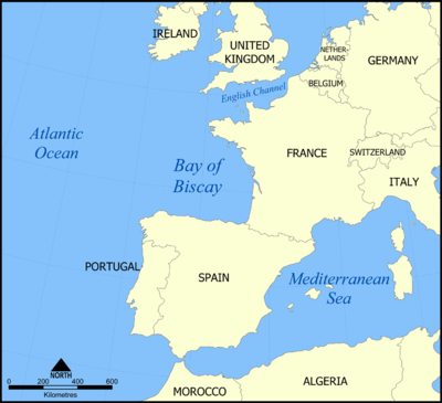
Seas of the World  The Bay of Biscay is located off the north coast of Spain and the west coast of France in the Atlantic Ocean, south of the Celtic Sea. The southern part of the Bay of Biscay along the northern Spanish coast is known as the Cantabrian Sea. The Bay of Biscay is known for its severe winter storms and early summer fog and rain. It is generally known as Golfo De Vizcaya in Spanish and Golfe De Gascogne in French.
While the Gulf Stream provides the greatest source of water input to the Bay of Biscay, freshwater discharges from the Loire, Gironde and Adour estuaries induce buoyant plumes which drive significant northward currents over the inner Armorican shelf.
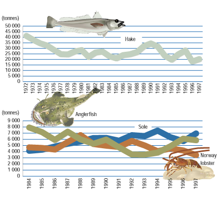
There is a conserable diversity of macro-fauna in the Bay of Biscay including a broad variety of marine mammals and over 200 species of demersal fish. Significant commercial fisheries are found here for Sole, Anchovy, Anglerfish, Norway lobster and other species. Numerous species of wintering and migrant seabirds are found along the shores; furthermore, several species of nesting seabirds exist in the Bay of Biscay ecosystem.
Contents
Geography and Physical Oceanography
|
The oceanic boundary of the Bay of Biscay is not universally and precisely defined, therefore the area given here is approximate. The bay of Biscay is generally reported by several to cover an area of 223,00 km2 (86,000 miles2) with an estimated average depth of 1,744 m and a greatest depth of 15,525 feet (4,735 m). Off the French part of the Bay, the continental shelf extends approximately 140 km in the north off the Brittany coast, but narrows to about 50 km in the south where France borders Spain. Along the coast of Northern Spain, the continental shelf becomes even narrower, in places extending only 12 km from the coast. A catchment area is defined by a number of hills and mountain ranges such as the hills of Normandy and Brittany, the Central Massif of France, the northern and western Pyrenees, the Basque Hills, the Cantabrian Range and the Galician Massif. River systems flowing in the Bay include:
The Garonne and Dordogne river system supplies that largest amount of runoff to the Bay (~31.2 km3/year) followed by the the Loire (~26.0 km3/year). Important ports on the Bay of Biscay include:
| |
|
In the northeast zone of the Bay (Brittany), the continental shelf is more than 140 km wide with gentle slopes. The shelf narrows to 50 km in the south (near the French/Spanish border). Off the northern coast of Span the shelf narrows in places to just 12 km. The fall off at the edge of the shelf ("shelf break") occurs at depths of around 200 m, beyond which is a steep slope with canyons and cliffs. Two exceptions to this pattern are "a few small terraces mainly to the north and the deep (500–800 m) Landes Plateau in the southern Bay of Biscay." (ICES, 2008) Off the South West Brittany coast, of the shelf is a large mud plain (300 km long and 30 km wide)known as La Grande Vasière (large muddy area) which is bordered by an extensive coral reef on the slope of the shelf. Beyond the continental shelf is the far deeper Biscay Abyssal Plain, whose generally flat topography covers about half of the Bay and has a maximum depth of 4550 m (15,000 ft). Other important physical features within the Bay include (Figure 2):
|
|
|
The major water mass in the Bay of Biscay is the Gulf Stream, which is referred to as the North Atlantic Current as it approaches Europe (Figure 3); a fork of which flows into the south part of the Bay before during north in a counter-clockwise circulation around the entire bay (Figure 4.) "Freshwater inputs from the Loire, Gironde and Adour estuaries induce buoyant plumes which drive significant northward currents over the inner Armorican shelf (Figure 4). As river water is considerably colder than sea water in winter and spring, the river plumes are easy to identify in satellite images of sea surface temperature. As shown by a recent three-dimensional hydrodynamic model (Lazure and Jegou, 1998), freshwater run-off imposes seasonal variability and its interaction with the wind-induced circulation promotes mesoscale variability." (OSPAR, 2000) |
 Figure 3. Gulf Stream and the North Atlantic Current. UC San Diego Figure 3. Gulf Stream and the North Atlantic Current. UC San Diego
|
 Figure 4. Schematic illustration of circulation in the Bay of Biscay. Source: Koutsikopoulos and Le Cann (1996)/OSPAR
Biodiversity
See: Celtic-Biscay Shelf large marine ecosystem
Marine Mammals
Information on the presence of marine mammals is based on past whaling activities, strandings on coasts and systematic and opportunistic sightings. A wide variety of species, both boreal and temperate, have been reported in the Bay of Biscay and Iberian Atlantic waters, including seven species of Mysticeti, twenty-three species of Odontoceti and seven Pinniped species.. The main habitats and status of these species is summarised in Table 1. (OSPAR 2000)
| Habitat | Status* | |
| Mysticeti | ||
| pelagic, continental shelf | rare, frequent | |
| pelagic | exceptional | |
| pelagic | frequent | |
| pelagic | exceptional | |
| pelagic | exceptional | |
| pelagic | rare | |
| pelagic | exceptional | |
| Odontoceti | ||
| pelagic | exceptional | |
| coastal, continental shelf | frequent | |
| pelagic | frequent | |
| pelagic | rare | |
|
Common dolphin |
pelagic, continental shelf | frequent |
| continental shelf | exceptional | |
| continental shelf | exceptional | |
| pelagic, continental shelf | frequent | |
| pelagic | exceptional | |
| pelagic, continental shelf | frequent | |
| pelagic, continental shelf | exceptional | |
| pelagic | rare | |
| Harbour porpoise | coastal | frequent |
| continental shelf | exceptional | |
| Sperm whale | pelagic | frequent |
| pelagic | exceptional | |
| pelagic | exceptional | |
| pelagic | rare | |
| Northern bottlenose whale | pelagic | exceptional |
| True’s beaked whale | pelagic | exceptional |
| Gervais’ beaked whale | pelagic | exceptional |
| Sowerby’s beaked whale | pelagic | exceptional |
| Blainville’s beaked whale | pelagic | exceptional |
|
Pinnipeda |
||
| coastal | exceptional | |
| coastal | exceptional | |
| coastal | exceptional | |
| coastal | exceptional | |
| coastal | rare | |
| coastal | exceptional | |
| coastal | exceptional |
- Frequent implies a species considered to be abundant or frequently sighted within the area; ‘rare’ implies a species within its main area of distribution but which is not abundant; ‘exceptional’ implies a species that has been observed in the area but which is outside its distribution range or is within its supposed range of distribution but which is extremely scarce.
The Grey seal (Halichoerus grypus) is permanent in Brittany, the southernmost breeding colony of the species, and in increasing in numbers due to dispersion of young from British breeding colonies.(ICES, 2008). The Common dolphin (Delphinus delphis) accounts for over half of all marine mammal strandings.
Fish
ICES (2008) reports: "Fish diversity is quite high in relation to the co-occurrence of subtropical, temperate, and boreal species, with relative abundances following latitudinal gradients. . . The main pelagic (not living near the bottom of the sea) species are sardine (Sardina pilchardus), anchovy (Engraulis encrasicolus), mackerel (Scomber scombrus), horse mackerel (Trachurus trachurus), and blue whiting (Micromesistius poutassou). . . . Seasonally, albacore (Thunnus alalunga) occur along the shelf break. Immature northern bluefin tuna (Thunnus thynnus) migrate to the feeding areas in the innermost part of the Bay of Biscay, from late spring to mid-autumn, returning to the Gulf of Cadiz and Atlantic Moroccan coasts in winter."
More than 200 species of demersal (living on or near the bottom of the sea) fish occur in the northeast Bay of Biscay but only five species make up more than 50% of the total biomass and abundance of demersal fish. The greatest diversity of species is found in coastal shallow waters, down to 50 metres. (ICES, 2008) The main commercial demersal species caught by the trawl are hake, megrims, monkfish, and sole. (ICES 2008).
The main elasmobranch species in the region are the rays, Raja clavata, R. montagui, and R. miraletus and the catsharks, Scyliorhinus canicula and Galeus melastomus, at the coast and on the inner and outer shelf, respectively (Sánchez et al., 2005a). Widely migratory sharks occur in this region such as Blue shark (Prionace glauca), Shortfin mako (Isurus oxyrnchus), Porbeagle (Lamna nasus), Tope (Galeorhinus galeus), and Spurdog (Squalus acanthias). Some are taken in trawl and longline tuna, swordfish, and scabbardfish fisheries. (ICES, 2008)
Birds
"Nesting seabirds in the area include European storm petrel (Hydrobates pelagicus), European shag (Phalacrocorax aristotelis), Yellow-legged gull (Larus michahellis), Lesser black-backed gull (Larus fuscus), Kittiwake (Rissa tridactyla), and Common guillemot (Uria aalge). Another group of 25 species are wintering or migrant seabirds along the northern Spanish coast (Valeiras, 2003; Valeiras et al., 2007). The most important species in terms of abundance are the Northern gannet (Morus bassanus), the Larus spp. gulls (7 species), the Balearic shearwater (Puffinus mauretanicus), the Manx shearwater (Puffinus puffinus), the Sooty shearwater (Puffinus griseus), the Cory’s shearwater (Calonectris diomedea), the Razorbill (Alca torda), and the Atlantic puffin (Fratercula arctica)." (ICES, 2008)
Fisheries
Phytoplankton
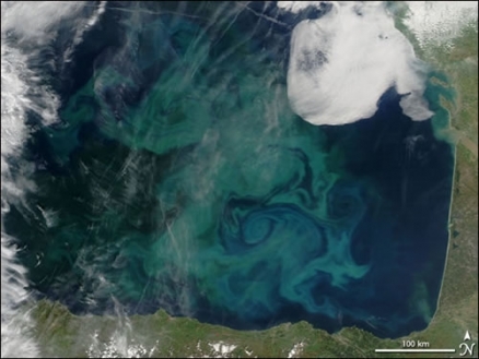
In March-April there is typically a rapid seasonal growth of phytoplankton (a bloom) in Biscay Bay (see image at article top) which covers the entire offshore region and then declines sharply from May onwards.
Governance
The eastern and northern part of the Bay is within the jurisdiction of France, while the southern and central part of the Bay is within the jurisdiction of Spain.
The Bay of Biscay is part of Region IV (Bay of Biscay and Iberian Coast) of the OSPAR Commission, "the mechanism by which fifteen Governments of the western coasts and catchments of Europe, together with the European Community, cooperate to protect the marine environment of the North-East Atlantic."
Much research in the Bay of Biscay is promoted and coordinated by the intergovernmental International Council for the Exploration of the Sea (ICES) which includes it within one of its areas of focus in the North Atlantic.
Litter
 Figure 6. Density of litter in the bay of Biscay. Source: IFREMER.
Further Reading:
- Physical Oceanography Index
- Seas of the World
- OSPAR Commission
- Quality Status Report 2000 Region IV Bay of Biscay and Iberian Coast, OSPAR Commission for the Protection of the Marine Environment of the North-East Atlantic
- Report of the ICES Advisory Committee, 2010 Book 7: Bay of Biscay and Atlantic Iberian Waters
- Report of the ICES Advisory Committee, 20108 Book 7: Bay of Biscay and Atlantic Iberian Waters
- XI International Symposium on Oceanography of the Bay of Biscay. ‘Revista de Investigación Marina’ 3: 289 pp. 2008
- Bay of Biscay and Western Iberia, International Council for the Exploration of the Sea (ICES). Report of the ICES Advisory Committee, 2008. ICES Advice, 2008. Book 7, 122 pp.
- La Grande Vasière - A Potential MPA, Sabine Christiansen, World Wildlife Fund
- Koutsikopoulos C. and Le Cann, B. 1996. Physical processes and hydrological structures related to the Bay of Biscay Anchovy. Sci. Mar. 60: 9–19.
- Lazure, P. and Jegou, A.M. 1998. 3D modelling of seasonal evolution of Loire and Gironde plumes on the Bay of Biscay’s continental shelf. Oceanol. Acta, 21: 165-77.
- Huret, M. 2005. Apports des données 'couleur de l'eau' à la modélisation couplée physique-biogéochimie en milieu dynamique côtier. PhD Thesis, University of Brest, France, 264 pp.
- Rodríguez-Marín, E., Rodríguez-Cabello, C., De La Serna, J. M., Alot, E., Cort, J. L., Macias, D., and Quintans, M. 2007. Bluefin tuna (Thunnus thynnus) conventional tagging carried out by the Spanish Institute of Oceanography (IEO) in 2005 and 2006. Results and analysis including previous tagging activities. ICCAT Stand.Com. Res. Stat. (SCRS)/2007/038.
- Souissi, S., Ibanez, F., Ben Hamadou, R., Boucher, J., Cathelineau, A. C., Blanchard, F., and Poulard, J. C. 2001. A new multivariate mapping method for studying species assemblages and their habitats: example using bottom trawl surveys in the Bay of Biscay (France). Sarsia, 86: 527–542.
- Poulard, J. C., Blanchard, F., Boucher, J., and Souissi, S. 2003. Variability in the demersal assemblages of the Bay of Biscay during the 1990s. ICES Marine Science Symposia, 219: 411–414.
- Bertrand J. A. 2004. L’état des communautés exploitées au large des côtes de France. Application d’indicateurs à l’évaluation de l’impact de la pêche. IFREMER report, DRV/RH/RST/04–001. 170 pp.
- Blanchard, F. 2001. Une approche de la dynamique des peuplements de poissons démersaux exploités: analyse comparée de la diversité spécifique dans le golfe de Gascogne (océan Atlantique) et dans le golfe du Lion (mer Méditerranée). Aquatic Living Resources, 14: 29–40.


