Angola Current
The Angola Current is the eastern part of a cyclonic gyre centered around 1oS and 4oE that is driven by the South Equatorial Countercurrent in the Atlantic Ocean. This subsurface circulation gyre extends from just below the surface to around 300 meters (m) depth with velocities of about 0.5 m/s in the section nearest the African coast. The confluence between this southward flowing current and the northward flowing Benguela Current near 16oS off the African coast is called the Angola-Benguela Front.
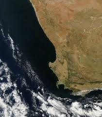
|
Atlantic currents west of Africa. |

Ecology
The Angola Current and its contact with the Benguela Current change over time, with a measurable change in location of the Angola-Benguela Front transpiring over a time frame of a few years to decades. The marine organisms that thrive in the two current zones have a dramatically different composition due to the temperature differential within the two currents; the Benguela Current is the cooler of the two.
Besides the temperature differential, there are some marked biogeographical consequences of the movement of the Angola-Benguela Front. For example, at the mouth of the Kunene River, which divides Angola from Namibia, there is a trapped ecosystem, which has formed disjunctive populations of a number of marine organisms, most notably Leatherback Turtles.
Angola-Benguela Front
The Angola-Benguela Front (ABF) is a oceanic front caused by the confluence of the southward flowing Angola Current and the northward flowing Benguela Current presently near 16oS off the African coast. This can be identified in the temperature of the upper 50 metres (m) and in the salinity to at least 200 m in depth. The ABF varies somewhat in its exact location depending upon the regional meteorology, but is generally in the vicinity of the border between Angola and Namibia at the mouth of the Kunene River.
Further Reading
- Peter Saundry. 2011. Seas of the world. Topic ed. C.Michael Hogan. Ed.-in-chief Cutler J.Cleveland. Encyclopedia of Earth.
- Matthias Tomczak and J. Stuart Godfrey. Regional Oceanography: An Introduction. Pergamon, 1994.
- H.U.Lass, M.Schmidt, V.Mohrholz, and G.Nausch. Hydrographic and current measurements in the area of the Angola–Benguela Front. J. Phys. Oceanogr., 30:2589–2609, 2000.
- G.Nelson. 1992. Equatorial wind and atmospheric pressure spectra as metrics for primary productivity in the Benguela system. S. Afr. J. Mar. Sci. 12: 19–28