Wetland (Wetland classifications)
Contents
Wetland classifications
Wetland Classification
Wetlands vary greatly in their genesis, geographical location, water regime, chemistry, and plant communities. To permit description of the wetlands in Canada, a classification system was developed by the National Wetlands Working Group in 1988. This system classifies wetlands on the basis of their biotic and abiotic characteristics. This system recognizes five main wetland classes in Canada: bogs, fens, marshes, swamps, and shallow open waters. Each of these classes of wetland is further divided into wetland forms based upon surface morphology, landform drainage, and proximity to water bodies. Finally, each form is broken down into different wetland types based upon vegetation morphology.
Bogs
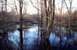
Bogs are the most common type of wetland in northern Canada, especially in arctic and subarctic regions. In fact, bogs are very common across the entire northern hemisphere in previously glaciated areas. Bogs are characterized by substantial peat accumulation (> 40 centimeters), high water tables and acidic loving vegetation. There are no significant inflows or outflows of water from a bog, resulting in stagnant, unproductive environments. Canada possesses 35% of the world's peat accumulating wetlands, termed peatlands.
Bogs are covered with a layer of floating vegetation which may look like solid ground. However, it is easy to fall through the bog surface into the pit of water below. In 1950, a sacrificial victim who was buried more than 2000 years ago in a Danish bog was found with his clothes and hair intact. As this case makes clear, the process of decay is slowed in bog environments.
Origin and Development
Many bogs lie in depressions created by the melting of ice blocks buried at the time of glacial retreat more than 10,000 years ago. Since this time organic debris has accumulated in these lakes, converting them into peat bogs, some over 50 feet deep. However, not all bogs began in old glacial lakes. Some bogs formed in sloughs and depressions where there is little or no drainage.

Different kinds of bogs arise under different conditions. Canadian bogs evolve from two main processes, terrestrialization (filling of shallow lakes) and paludification (blanketing of terrestrial ecosystems by overgrowth of bog vegetation). Quaking or basin bogs develop via the terrestrialization of kettle lakes, gouged out depressions, and dammed valleys. A mat of vegetation (floating or partially rooted in the basin bottom) gradually develops from the edges, migrating toward the middle of the lake and is soon consolidated by Sphagnum moss, other bog plants, and trees along the edges of the mat. Peat continuously accumulates, isolating the plants from their nutrient supply so the bog becomes increasingly nutrient poor. Over time the bog mat may cover the entire bog surface so there is no longer any open water. More trees begin to root and peat accumulation persists. The area may evolve into a bog forest which is differentiated from a swamp by the presence of Sphagnum. The term quaking bog is derived from the quaking sensation one feels while walking across these floating vegetative mats.
Raised or domed bogs evolve through a variation of terrestrialization in old glacial lake basins or in shallow plains. These bogs have a convex surface and pools of water encircle the central area. Peat deposits fill the entire basin and isolate the bog from groundwater sources. In this case, its own hydrological system is created which acts to raise the local water table. However, a permanently high water table cannot be maintained and the bog becomes isolated from all water sources except precipitation. Trees or shrubs often establish themselves on the outer margins of these bogs.
Another common type of bog, especially in the maritime region where there is an abundance of moisture, is the blanket bog. Blanket bogs arise from paludification where peat spreads beyond the boundaries of the basin encroaching on formerly dry land. Paludification may be induced by climate change, construction of beaver dams, logging of forests or by the natural advancement of the peatland. The lower layers of peat compress, becoming impermeable, resulting in a perched water table near the surface of the former mineral soil. Wet, acidic conditions arise that may kill or stunt trees, allowing bog species to persist.
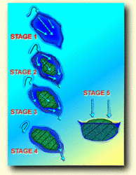
The final type of bog evolution is flow-through succession. These bogs arise through a combination of terrestrialization and paludification. In this case, the development of peat modifies the surface flow of water. This type of bog forms in a basin of a lake that originally had continuous inflow and outflow of surface and groundwater. The successional pattern is outlined below.
- Stage 1: A buildup of material in the lake basin occurs from the inflow of sediments and the production of excess organic matter.
- Stage 2: The buildup of peat continues until the bottom rises above the water level and the flow of water is channeled around the peat.
- Stage 3: Peat continues to accumulate until the major inflow of water is diverted.
- Stage 4: Areas may develop that are cut off from the past water source and become inundated only during high rainfall.
- Stage 5: The bog remains above the groundwater level and becomes ombrotrophic.
Peatlands only develop in areas where precipitation exceeds evapotranspiration leading to moisture accumulation. Bogs are common in the arctic regions of Canada which are characterized by low precipitation but evapotranspiration rates are also extremely low. Bogs are especially common in the mid- and low arctic regions where there is more precipitation than in the high arctic. Permafrost and frost action play a major role in facilitating the formation of polygon shaped bogs which are common in the arctic.
Vegetation and Wildlife
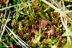
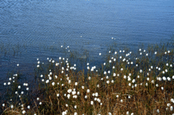
The plants which grow on bogs are unique species, adapted to wet, acidic, and nutrient-poor soils. The edge of the bog mat is a region of new growth, often beginning with reeds, followed by shrubs and trees. Moss growth creeps over the surface increasing the acidity of the environment. This kills existing plants but new vegetation grows which tolerates this low pH. Sphagnum moss is the dominant plant in bogs but some uncommon wildflowers, especially orchids, are also found in these environments. The mosses grow in cushion-like, spongy mats often associated with cotton grass and willow shrubs. Tamarack or black spruce trees are open-canopied and stunted. Moose are frequently seen feeding at the edges of these wetlands and songbirds take cover in the trees surrounding these bogs. Few amphibians live in bogs as they cannot withstand the highly acidic conditions.
Hydrology
Bogs are ombrotrophic referring to their lack of a connection with groundwater, lakes or rivers. During their early development, bogs may still be connected to groundwater or other sources of water, but as they develop precipitation becomes their sole water supply.
Soil

Mineral [[soil]s], sands and gravels cover the original bog floor. However, these soils are overlain by peat accumulation. The main types of soils found in bogs are Fibrisols, Mesisols, and Organic Cryosols (permafrost soils). In order to fully understand the formation of bogs, one must study the accumulation of peat. The accumulation of peat in bogs is determined by the production of litter from primary production and its slow decomposition. Primary productivity is minimal due to low nutrient levels and pH, but mosses thrive in these environments. Since bog waters are covered with a layer of mosses and peat, there are no underwater plants (Aquatic plants) or wave action to introduce oxygen. The low oxygen levels and acidic conditions slow decomposition, leading to an accumulation of organic matter in a form called peat.
Near the surface of the bog or fen, decomposition rates are higher due to the availably of oxygen. As one progresses downward, decomposition rates drop due to increasing anaerobic conditions. Any decomposition that does occur is due to microorganisms in the soil.
String bogs develop in northern Canada as a result of differential rates of peat accumulation. String bogs have pools of water between ridges of peat accumulation. Decomposition occurs faster in hollows than on ridges, with accumulation rates as great as 100 - 200 centimeters (cm) per 1,000 years in North America.
pH
The water in bogs is acidic with pH levels varying from 3 to 5. The acidity derives from cation exchange with mosses, oxidation of sulfur compounds and presence of organic acids. Sphagnum moss requires calcium, Magnesium, and sodium ions for growth and absorbs them from the water. To prevent a buildup of positive ions (since these ions are positively charged) and to aid in their uptake from the water, the moss releases hydrogen ions (H+) causing the pH in the peat and water to drop. This process is known as ion exchange.
Trophic State
Bogs are oligotrophic which means that they have very low productivity. The few nutrients available to support plant growth derive from precipitation.
Fens
Fens are a type of peatland which resemble bogs as they too contain at least 40 cm of peat. However, fens support marsh-like vegetation including sedges and wildflowers. This type of wetland is found throughout Canada but is most common in arctic and subarctic regions. The main differences between fens and bogs are in flora, hydrology and water chemistry.
Origin and Development
Fens are fragile environments and walking across one may leave footprints which last for decades. Fens evolve similarly to bogs, and show a lack of oxygen and bacteria which results in slow decomposition of organic material, leading to the accumulation of peat. This accumulation can fill lake basins and depressions in the landscape. Since fens and bogs accumulate peat, many argue that fens are simply developing bogs.
The two most common types of fens in Canada are raised and ribbed fens. Raised fens form in old glacial lake basins or in shallow plains where the water table meets the surface of the land. Vegetation overlaying accumulated peat grows upward resulting in a raised appearance. Ribbed or patterned fens have parallel peat ridges with pools of water oriented perpendicular to the direction of slope and drainage. The peaty ridges and pools can comprise 75% of these two types of patterned fens. Many bogs in southern Ontario in limestone basins resemble fens, as the limestone elevates alkalinity and increases vegetation diversity and peat decomposition.
Vegetation and Wildlife
One of the main distinguishing features between a fen and a bog is the difference in flora. Fens lack the abundant Sphagnum moss growth which characterizes bogs, but they support more marsh-like vegetation including sedges. Where nutrient levels are sufficient, there are wildflowers, cedar or tamarack trees, and shrubs, increasing habitat for animals. Fens have a greater diversity of plant species than bogs due to their increased nutrient levels.
Hydrology
Fens generally have a high groundwater level and occupy a low point of relief in a basin. There is usually very slow internal drainage of the fen through seepage. True fens receive water that has passed through mineral soils and are referred to as minerotrophic. Poor fens are intermediate between mineral nourished water and mineral deficient water (ombrotrophic).
Soil
Soils found in fens are mainly Mesisols, Humisols and Organic Cryosols. However, the mineral soil is covered by a layer of peat at least 40 cm thick, which accumulates because of slow rates of microbial degradation.
The water in fens can vary from slightly alkaline to slightly acidic with pH values ranging from 5 to 8. Fens are less acidic than bogs due the lesser abundance of Sphagnum and their occurrence on a limestone or clay base which increases their alkalinity. See the water chemistry section in General Features for a more detailed explanation.
Trophic State
Streams, runoff and groundwater provide nutrient enrichment to fens. Therefore, fens receive more nutrients than bogs which increases their productivity. However, they are generally not very productive environments.
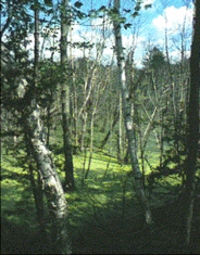
Swamps
A swamp is a wetland class associated with streams, rivers or lakes which has water flowing through it. They are often confused with marshes but are distinguished by the presence of trees and shruss. Swamps occur on saturated [[soil]s] and are flooded for most if not all the growing season. The main swamp regions in Canada are Vancouver Island, the southern Pacific Coast and the Great Lakes region.
Origin and Development
Swamps develop in depressions where there is poor drainage and/or the water table is high. Despite the water trapped in these areas, they are colonized by trees. These [[forest]ed] wetlands develop in still or slowing flowing water around lake margins, along floodplains, and by oxbow lakes.
Poorly drained depressions and areas subject to periodic flooding have mucky soils that are too wet for surrounding forest species but are ideal for swamp plants (Aquatic plants). Swamps may evolve from sedge and cattail marshes as water levels decrease due to organic matter accumulation, sedimentation or lowering of the water table. As water levels decrease, red maples and other swamp species become established and as they grow, they shade out light demanding marsh plants. Marsh animals such as ducks and muskrats leave the area and are replaced by swamp species.
Swamps may develop on the surface of old fens and bogs (peatlands), after terrestrialization is complete. In fact conifer swamps are often mistaken for bogs. As a bog develops, the open water area may eventually be covered with a vegetative mat and trees can become well established. However, the presence of moss and wet, spongy ground distinguishes a bog from a swamp. A conifer swamp is established with the same trees as a bog, but there is no moss and the area is flooded for a part of the year with water from rivers, lakes, spring runoff or groundwater.
Vegetation and Wildlife
The vegetation in swamps is predominately dense coniferous or deciduous forest or tall shrub thickets. The trees which inhabit a swamp are dependent upon climatic conditions. Northern boreal swamps are usually dominated by white and black spruce but more nutrient-rich sites have cedars. As one progresses south, red maple, ash and yellow birch become more common in swamps. In southern Ontario, swamps are dominated by the silver maple. Ferns, blueberries, touch-me-nots, orchids, and skunk cabbage are common swamp plants.
Swamps provide habitat for a wide variety of wildlife and in many parts of rural Ontario, swamps are the only remaining natural cover for larger wildlife, such as deer. Common swamp animals include wood frogs, salamanders, and both wood and black ducks.
Hydrology
Swamps may be flooded with water on a permanent, semipermanent or seasonal basis. However, most swamps are flooded for much of the growing season. Swamps are reservoirs of water which may be important in times of drought. Standing or gently moving water in swamps is seasonally or periodically flooded, leaving the subsurface continually waterlogged. Groundwater is the primary source of water in swamps.
Soil
Swamps have a mixture of mineral and organic [[soil]s]. There is usually a peat layer which is different from that in bogs and fens because it is woody and humified rather than being derived from mosses. High oxygen levels and abundant decomposers create conditions which prevent extensive peat accumulation. Oxygen levels are high due to the constant aeration from flowing water and plant life beneath the surface of the water. As plants photosynthesize they release oxygen into the water. The water table may drop seasonally below the rooting zone of vegetation which also aerates the surface. Although many of the wetlands in southern Ontario have been drained, some swamps remain because they are poor agricultural lands.
pH
The water in swamps is usually neutral with a pH of approximately 7.2.
Trophic State
Swamps are generally nutrient-rich, productive and have lush vegetation. The primary productivity of a swamp is closely tied to hydrological conditions. The highest productivity occur in a pulsing hydroperiod wetland that receives high inputs of nutrients, while lower productivity characterizes either drained or continuously flooded swamps.
Marshes
Marshes are frequently or continually flooded wetlands characterized by emergent herbaceous vegetation adapted to saturated soil conditions, changing water flows, and mineral soils. Marshes contain shallow water varying from 15 to 90 cm in depth. Expansive stretches of open water are uncommon and islands of vegetation are often present. Marshes are the most common wetland type in North America.
Marshes are separated into freshwater and saltwater types. Freshwater marshes are primarily inland, while salt marshes line the coasts of North America. The main freshwater marsh areas in Canada are the prairie potholes and the Great Lakes marshes. Coastal salt marshes lie along Hudson and James Bay, as well as the Atlantic, Pacific and Arctic coastlines.
Origin and Development
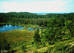
Freshwater marshes are the most abundant and broadly distributed wetlands in Canada. Most marshes occur along the borders of lakes, ponds, rivers. The prairie pothole marshes stretch from the upper mid-west of the United States, to the south-central portions of Canada across the three prairie provinces. These habitats have been evolving for over 10,000 years, as depressions filled with water from melting glaciers. These glacial sloughs and depressions are dominated by marsh plants, ducks, muskrats and other marsh organisms. Most prairie potholes are freshwater but some are saline, closed systems which have accumulated salts leached from their watershed.
The marshes surrounding the shores of the Great Lakes were originally formed in river deltas and protected shallow areas, often behind natural barrier beaches or levees created by wave action on the shore. Since water levels were stabilized along the Great Lakes, many of the remaining Great Lakes marshes are now managed and protected from water level changes by artificial dikes. Beaver dams contribute to the formation of freshwater marshes as older dams breakdown and leak.
Tidal salt marshes flourish where the accumulation of sediments is more than the rate of land subsidence and where there is adequate protection from destructive waves and storms. The structure and function of salt marshes are impacted by the frequency and duration of tidal flooding, soil salinity and nutrient levels, especially nitrogen. Salt marshes can be narrow fringes on steep shorelines or up to several kilometers in width. They are found near river mouths, in bays or lagoons on protected coastal plains.
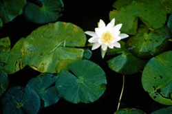
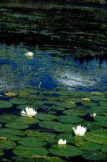
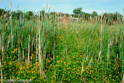
The vegetation in freshwater marshes is characterized by tall reeds and rushes such as Typha and Phragmites, grasses and sedges such as Cyperus and Carex. Pickerelweed, Pontederia cordata, often adds color to the surface waters. There are also broad-leaved plants such as Sagittaria and floating aquatic plants such as Nymphaea, Nelumbo, and the yellow pond lily Numphar. Due to their abundant vegetation, marshes provide an invaluable food source for many animals.
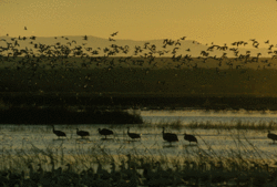
The muskrat and mink are two of the most important mammals in freshwater marshes. Muskrats open pathways for fish and other animals in the dense cattails. Turtles and frogs are abundant in these waters while ducks and waterfowl use marsh habitats for feeding, shelter and reproduction.
Coastal marshes support salt-tolerant grasses and rushes whose composition varies in response to the frequency and duration of tidal flooding, soil salinity and nutrient levels. Arctic marshes usually have numerous inflowing streams and contain brackish rather than saline water. Various species of sedges and grasses dominate these habitats. In the Bay of Fundy marshes, river and tidal erosion is high, producing an abundance of reddish silt. The large tidal range leads to few marshes in protected areas. Puccinellia americana dominates marsh while Juncus balticus is found on higher marshes. On the western coasts, salt marshes are poorly developed because of the geomorphology of the coastline. A narrow belt of Spartina foliosa is often bordered by broad belts of Salicornia and Suaeda. Fish, waterfowl and an array of invertebrates make their homes in the brackish or saline waters of coastal marshes.
Hydrology
Although marshes may receive water from groundwater, precipitation or runoff, flooding from adjacent water bodies is usually their most important source of water. Marshes are subject to a gravitational water table, yet water remains within the rooting zone of plants for most of the growing season. There is a relatively high oxygen saturation.
Most freshwater marshes intercept groundwater and their water levels therefore reflect the local water table and contribute to it. Although less than 20% of the water impounded in freshwater wetlands enters the groundwater supply, this volume is often an important contribution to the watershed. Inland marshes are generally mineralotrophic, the inflowing water shows zonal or mosaic surface patterns composed of pools or channels interspersed with clumps of emergent vegetation. Coastal salt marshes are typically found in areas that are at least occasionally inundated by high tide but not flooded during low tide. A gentle shoreline slope allows for tidal flooding and stability for rooting vegetation.
Soil
Marshes are underlaid with Gleysols, Humisols and Mesisols. Sand and gravel often cover the mineral soil and marshes lack a distinct peat layer. There may be an accumulation of organic matter resulting from high production but not from the inhibition of decomposition by low pH. A high population of soil microbes contribute to the rapid decomposition of organic material. In coastal marshes, the sediments that build salt marshes originate from upland runoff, marine reworking of coastal shelf sediments, or organic production within the marsh itself.
pH
Marshes have neutral to alkaline waters with pH values around 7 or 8.
Trophic State
Marshes are among the most productive ecosystems on earth. Coastal marshes have nutrient rich waters and are often particularly eutrophic. Inland marshes have a medium to high nutrient loading but not as high as those in tidal marshes. Flooding in inland marshes tends to result from seasonal changes in rainfall, subsequent runoff and evapotranspiration. Therefore, groundwater sources are more important to inland marshes as a source of nutrients. There is high soil-microbial activity that leads to rapid decomposition, rapid nutrient recycling and nitrogen fixation. Most of the primary productivity is routed through detrital pathways but herbivory can be important, particularly by muskrats and geese.
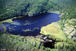
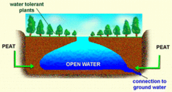
Shallow Open Water
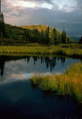
Shallow open waters are small bodies of standing or gently flowing water that represent a transitional stage between lakes and marshes. They vary greatly in physical and chemical composition. Their mid-summer depth is less than 2 meters (m) and open expanses of water comprise at least 75% of their area. Ponds, pools, oxbows and channels are all different types of shallow open water. Their surface is free of vegetation except for aquatic macrophytes. Unlike lakes, the water temperature in shallow open waters is uniform, lacking any stratification.
Origin and Development
Shallow open waters arise from the same processes which produce lakes, so you may refer to the Lakes section for a more detailed description of their modes of origin. Shallow open waters in Canada were formed most commonly through glacial action. However, many are also man-made [[habitat]s] such as irrigation ponds, watering holes for livestock, and reservoirs. Shallow open waters may often develop into other types of wetlands, such as swamps or marshes.
Common types of shallow open waters in Canada include delta and channel ponds. Delta ponds result from the impounding of waters by shifting river channels and sedimentation. Channel water is shallow intermittently flowing water in abandoned eroded glacio-fluvial spillways, where the water source is from spring snowmelt or exceptionally high precipitation.
Vegetation and Wildlife
Common vegetation in shallow open water includes milfoils (Millefolium), water hyacinth (Eichhornia crassipes), duck weed (Lemna spp.), and water lilies. They are usually free of emergent vegetation, but floating, aquatic macrophytes may be present. Amphibians, reptiles, crustaceans, mammals, and fish all thrive in these [[habitat]s]. Beavers and moose can often be found near shallow open waters.
Hydrology
Shallow open waters are usually connected to sources of groundwater and receive additional inputs from runoff, precipitation and other water bodies. Their depth is usually less than 2 m. Shallow open waters are characteristic of intermittently flooded, permanently flooded or seasonally stable water regimes. They may dry out due to water losses from seepage or evaporation.
Soil
The [[soil]s] in shallow open waters tend to be mucky and highly organic. Many are underlain with sands and gravels. Soil type is highly dependent upon their origin. See the lakes section.
pH
The pH of shallow open waters is dependent upon their water source, soils, bedrock, and mode of origin. Their pH range is similar to that of lakes.
Trophic State
Shallow open waters tend to be highly productive. Since they are connected to many water sources, there are varied nutrient inputs. High vegetation density in these areas provides water, food and shelter for many animals.
Wetland Forms
Wetland forms are the second classification level developed by the National Wetlands Working Group. Forms are dependent upon the surface morphology of the wetland (flat, raised, sloping), presence of patterns (ridges, nets, palsa mounds, polygons), position in the landscape (valley, delta, basin), tidal effects and proximity to water bodies. The forms reflect the differences caused by environmental factors including the origin of the water (rainwater, groundwater flow, and water bodies), differential peat development and permafrost (palsas and polygons). To date the five wetland classes have been divided into 70 forms including 18 bog forms, 17 fen forms, 15 marsh forms, 7 swamp forms, and 13 shallow open water forms.