West Norwegian Fjords – Geirangerfjord and Nærøyfjord, Norway
Contents
- 1 Geographical Location
- 2 Dates and History of Establishment
- 3 Area
- 4 Land Tenure
- 5 Altitude
- 6 Physical Features
- 7 Climate
- 8 Vegetation
- 9 Fauna
- 10 Cultural Heritage
- 11 Local Human Population
- 12 Visitors and Visitor Facilities
- 13 Scientific Research and Facilities
- 14 Conservation Value
- 15 Conservation Management
- 16 IUCN Management Category
- 17 Further Reading
Geographical Location
The West Norwegian Fjords are a World Heritage Site located in southwestern Norway 240 kilometers (km) and 120 km northeast of Bergen. The Geirangerfjord area lies 60 km inland between 62° 00’ - 62° 17’ N and 06° 55’ - 07° 24’ E in Møre & Romsdal county. The Nærøyfjord area, 120 km to its south, lies 100 km inland between 60° 45’ - 61° 09’ N and 06° 41’- 07° 16’ E in Sogn & Fjordane and Hordaland counties.
Dates and History of Establishment
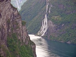 A waterfall in the Geirangerfjord area in Norway. (Source: Wikimedia)
 - 1933: Hatle-Styve Natural Monument designated, for a distinctive tree
- 1970: The Nature Conservation Act decreed the protection of all significant natural features, Protected Landscapes, Nature Reserves and Natural Monuments; it succeeded a similar act passed in1905
- 1978: The Cultural Heritage Act was passed to protect all pre-Reformation (1537) monuments and sites, establishing a 5 km buffer zone around each; later extended to cover all pre-1650 monument
- 1984: Kallskaret Nature Reserve designated, for geology and scenery
- 1985: Planning and Building Act: Environmental Impact Assessments were required nation-wide for all major new developments affecting natural or cultural assets
- 1995: Grånosmyrane Nature Reserve designated, for its wetland and bird life
- 1999: Nordhelmsdalen Nature Reserve designated, for virgin pine woodland
- 2002: Nærøyfjorden Protected Landscape Area designated, for a natural and cultural landscape
- 2003: Hyskjet Nature Reserve designated, for its woodland
- 2004: Geiranger-Herdalen and Bleia-Storebotnen Protected Landscape Areas and Bleia Nature Reserve; proposed for scenery, geology, wildlife and cultural landscapes: approval expected
Area
- Total area: 122,712 hectares (ha). Land: 111,966 ha (including settlements); Fjord: 10,746 ha
- Geirangerfjord: 51,802 ha. Land: 46,151ha; Fjord: 5,651ha
- Nærøyfjord: 70,910 ha. Land: 65,815 ha. Fjord: 5,095 ha
Land Tenure
Public. The State owns 14.5% of the areas (17,771 ha). Privately owned lands comprise 81.6% of the areas (100,103 ha); the nature conservation areas cover 96.1% of total area.
Geirangerfjord. Total area excluding settlements: 49,887 ha.
Private land: 45,302 ha owned by 330 owners;
State owned area of fjord: 4,585 ha.
Protected areas are under the management of the Governors of Møre & Romsdal county.
Nærøyfjord. Total area: excluding settlements: 68,346 ha.
Private land: 55,160 ha owned by 262 owners; State owned land: 9,800 ha;
State owned area of fjord: 3,386 ha.
Protected areas are under the management of the Governors of Sogn & Fjordane and Hordaland counties. The Borough Councils in each sector are responsible for the management of inhabited areas.
Altitude
Sea level to 1,850 meters (m) [[mountain] above Geirangerfjord) and 1,761m (Stiganosi mountain above Nærøyfjord).
Physical Features
These dramatic fjords are the grandest landscapes in a country of spectacular fjords, and the rivers which enter them have not been developed for hydroelectric power. Each is at the upper end of a major fjord system that developed along faults and fracture zones at right angles, giving them a characteristic zigzag form. Both fjords are submarine hanging valleys, which have floors between 300-500 m deep in ice-scoured basins, the floor of Nærøyfjord ending 1,000 m above the floor of Sognefjord. Though their differences are not dramatic, the two areas comprising the nominated property complement each other.
The Geirangerfjord area is 60 km inland at the end of Storfjord. It branches into two: Sunnylvsfjord of which Geirangerfjord is a branch, and Norddalsfjord of which Tafjord is a branch. Its fjords are 1-2 km wide and their sides reach a height of 1,300 m in places with old transhumance farms in the hanging valleys. They are surrounded by mountains 1,600-1,700 m high, carrying glacial lakes. The highest peak, Torvløysa, 1,850 m, rises north of Geiranger. The Geirangerfjord mountains are more alpine in character than those of the more southerly Nærøyfjord; block fields are more prevalent there and permafrost and glaciers persist on the highest summits. Nærøyfjord is located 100 km inland near the end of Sognefjord, and Aurlandsfjord branches off it. Its fjords are 250 m - 2.5 km wide with sides in places 900-1,400 m high. The surrounding mountains are smooth-topped with high glacial lakes, a plateau glacier in Fresvikbreen and reach to 1,761 m in Stiganosi, above the Syrdal glacier. The uplands of Nærøyfjord preserve much of the rounded landforms of the pre-glacial fluvial-dominated landscape.
The Management Plan describes five main landscape types in the area. The fjord system with shore areas and undisturbed hillsides where the physical relief is more prominent than any other feature. Farms of three distinct types with their surrounding cultural landscapes: fjord-side, valley and mountain-ledge. Valleys of which a large number extend into the mountains, have been used for centuries for transhumant summer grazing and are marked by pastures and sheilings. Woods which are deciduous in the valleys and on mountainsides, coniferous at higher elevations. On mountains the tree line is at 900 m and 1,100 m, up to 1,300-1,400 m the vegetation is alpine. Above this the landscape becomes one of scree, block fields, snow fields and, over 1,700 m, glaciers.
Geologically, the areas are extremely well-developed examples of fjord landscape and excellent examples of young active glaciation. Relatively recently, in geologic terms, the products of glacial weathering were removed, leaving ice- and wave-polished surfaces on the steep fjord sides which provide superbly exposed and continuous three-dimensional sections through the bedrock. In Geirangerfjord these are Precambrian gneisses of the West Gneiss Region, a world-class example of deeply subducted continental crust and of well preserved high-pressure rocks. In Geirangerfjord there are outcrops of peridotite and serpentinite in the predominant gneiss bedrock. In Nærøyfjord. the underlying rocks are anorthosite and gabbro, with softer phyllite in Aurlandsfjord. The high mountain surface is a slightly undulating peneplain dissected by rivers, the courses of which were deepened, widened and scoured 20,000 years ago by the glaciers of the last Ice Age. Later melting of the heavy ice cap allowed the land to rebound by some 110 m, deepening the fjords, and by 5000 years ago most of the glaciers had disappeared leaving thick till in places and many moraines. Where fractured, the crystalline rocks are unstable and in weathering have created a wide variety of rock-slide scars and slumps, active screes and snow avalanche paths. Unpredictable rockfalls are still frequent hazards and, in extreme cases, have created local tsunamis in the enclosed waters of some fjords (62 m high in Tafjord in 1934). Most of the soils derived from gneiss and anorthosite are nutrient-poor, but there are pockets of richer soil on the other minerals and from newly eroded slides.
Climate
This is transitional between oceanic and continental, but varies markedly with aspect and altitude. Approximate measurements can be given based on nearby readings: the average annual temperature for the Geirangerfjord area is 6.6 degrees Celsius (°C), ranging from 0.5°C in January to 13.8°C in July with an average rainfall of 1180 millimeters (mm), decreasing towards the east. Nærøyfjord being further inland is some 1.5°-3°C colder and 120 mm drier. Snow persists from October to late May on the mountains and from late November to March in the valleys of the northern site, but only 2-3 weeks at Nærøyfjord. Winter ice periodically ices over the fjord heads for 1-3 weeks, though in Nærøyfjord it lasts longer. Large [[avalanche]s], of both powdery snow and wet slabs regularly occur. The narrow valleys can generate strong down-valley winds, and avalanche air blasts can be very dangerous.
Vegetation
The vegetation is typical of this part of West Norway, but it is moderately diverse despite the nutrient-poor soils. This is because of the range of gradients from coast to inland, from north to south, from sea level to 1,600 m and the consequent variety of terrains and microclimates. Pockets of peridotitite and serpentinite rocks in the Geirangerfjord area give nutrient-rich soil. Its main vegetation types are temperate woodland, rock and scree, alpine grassland and man-made meadows. The woodland includes old deciduous woods, pinewoods on peridotite, wooded pasture and small patches of very diverse deciduous woods on warm south-facing slopes. Around Nærøyfjord woodlands are similar but vary with the soil, moisture, exposure, altitude above sea level and use. There are large natural woods of Scots pine Pinus sylvestris, but birch Betula spp. woodland communities are the most common. A somewhat richer grey alder Alnus incana community dominates on avalanche fans beside the fjords. The best virgin pine woodland in western Norway is found in Nordheimsdalen and below Bleia. In a belt of phyllites around Flamsdalen 500 species have been recorded including unusual species.
The Alpine flora of the Geirangerfjord area is dependent on snow cover and ranges from dwarf birch Betula spp. and polar willow Salix polaris to herb-rich grassland; the grassers of the grazed meadows host many rare fungi. Above the tree line which is between 800 m and 900 m are scree, blockfields, snow fields and glaciers. The tree line above Nærøyfjord is between 900 and 1,100 m. Half the alpine flora of Norway is found on its high mountains, on carbonate rocks and lenses of phyllite. In the ungrazed high land of Bleia there is natural grassland and, on its screes, a rare sub-species of arctic poppy Papaver radicatum ssp. relictum.
Fauna
 Nærøyfjord makes for one of the grandest landscapes in Norway. (Source: Wikimedia)
 These districts are one of few areas in Norway where all four native deer occur together: reindeer Rangifer tarandus, three separate strains of which are found here, the rarer elk Alces alces in the east, red deer Cervus elaphus and roe deer Capreolus capreolus. Arctic foxes Alopex lagopus, brown bears Ursus arctos, lynx Lynx lynx, wolverine Gulo gulo (VU) and otter Lutra lutra (VU) are occasionally seen. Marine species have been well surveyed only in Nærøyfjord where the water is unpolluted and 76 species, including Atlantic salmon Salmo salar, are recorded. Species common in deep seawater are found here in much shallower water, including Norway lobsters and sea pens, one from a depth of more than 300 m down Kophobelemnon stelliferum, occurring here at a depth of 35 m. A common seal Phoca vitulina colony of 15-30 individuals has a pupping site in Nærøyfjord, and the common porpoise Phocoena phocoena is common in both areas. White-beaked dolphins Lagenorhynchus albirostris, sperm whales Physeter macrocephalus, minke whales Balaenoptera acutorostrata and killer whales Orcinus orca occasionally occur. Some 100 bird species breed in the area, all typical of western Norway, but because of the diversity of habitats they range from coastal birds to high mountain species. The rivers have the densest population in Norway of the national bird, the dipper Cinclus cinclus. The alpine and subalpine mires attract many waders and the cliffs host several raptors. The invertebrate fauna is not well known, but most of the habitats may have quite a rich range of species.
Cultural Heritage
Many carefully recorded relics are present in the area such as Neolithic tools, burial mounds, hunting hides and reindeer pitfall traps in the mountains, some of which were still in use 400 years ago. Viking houses a thousand years old are present and over 350 registered old buildings. These include stave churches (Undredal church dates from 1147), abandoned farms, some perched high on fjord sides, and transhumance farm sheilings. Farming was the main source of income until the mid -19th century when emigration accelerated and tourism began to become important.
Local Human Population
A population of 473 people exists within the nominated area. This is relatively dense for a mountainous region of Norway but it only inhabits 1.4% of the total area. In Geirangerfjord there are 230 people in two settlements of which Geiranger is much the larger. In Nærøyfjord there are 243 people in four small settlements. The main local villages of Flam and Aurlandsvangen border the site. These valley settlements are at river mouths and fjord heads at points at least risk from [[avalanche]s]. There are 56 farms within the Nærøyfjord area of which 12 main farms and 24 smaller holdings are still worked. In the Geirangerfjord nominated area there are 12 working farms and 24 with grazing. The average area is ten hectares, with orchards, small arable infields and much grazing mainly for goats and sheep using the marginal upland valleys. Hunting is undertaken to cull the deer but local fishingis now mostly recreational.
Visitors and Visitor Facilities
These fjords are one of the cradles of scenic tourism in Europe, visited for more than 150 years by scientists, artists and tourists. Their values having been preserved by their steepness and inaccessibility, the two fjords remain among the least affected by development and have attained iconic status. Local people have learned to cope successfully with great numbers of tourists without degrading the landscape. More than a million people are believed to visit the areas annually. Most touring is done from cruise ships (151 in Geirangerfjord in 2003, 157 in Nærøyfjord in 2002) but the fjords can be reached by car, train, boat and by foot along a number of good trails and roads: Nærøyfjord is on the main Bergen to Oslo highway. The Tourist Board figures for visitors arriving by cruise ships in 2002 are 378,000 for Geirangerfjord and 296,800 for Nærøyfjord, totalling about three-fifths of the total visitor numbers to each area.
Geiranger has four large modern hotels, the Norwegian Fjord Centre, a national Geological Park and a tourist information center. In 2004 the world’s largest cruise liner visited the fjord. There are many hotels, guesthouses, holiday flats, cabins and campgrounds in both areas, most in Nærøyfjord being outside the nominated site. A tourist information office exists there and a Fjord Heritage Foundation is to be established there. Both areas have traditional working farms on display: Herdalssaetra in the upland above Geirangerfjord, Styvi farm and museum on Nærøyfjord. There are guided walking and boat tours. Maps, guides and documentation for the area, including films, are excellent.
Scientific Research and Facilities
There has been continuous investigation of aspects of the terrestrial biology since the mid-18th century, now recorded on the National Database. A report on the entire biological diversity of the Geirangerfjord area was published in 2001 and the birds of rivers in the Nærøyfjord area were also recorded. Marine investigations have been fewer, but the waters of the Nærøyfjord area and the seals of Sognefjord have been studied. Both areas are important for geomorphological research, having some features seldom seen elsewhere or revealed so clearly. Historic rockslides and the related tsunamis such as the Tafjord disaster became internationally known through early studies; and the continuing active mass movements on the steep slopes create opportunities for useful research into geohazards. The recently established International Centre for Geohazards financed by the Norwegian Research Council, will focus on this region in future. The [[avalanche]s] and landslides can be used as indicators of climatic change, using the records of past events: several sites around Geirangerfjord have been studied for the frequency of avalanches, and connections have been made with changes in meteorological conditions. The sites are also recorded on a National Register of Valuable Cultural Landscapes.
Conservation Value
The starkly dramatic landscapes of Geirangerfjord and Nærøyfjord are exceptional in scale and grandeur in a country of spectacular fjords. They are extremely well-developed and pristine examples of a classic fjord and glaciated landscape which is still actively evolving. The West Gneiss Region is among the most important reference landscapes of its type in Europe.
Conservation Management
The areas have a tradition of conservation. Maintenance of their natural condition is essential to tourism in the area. The Protected Landscapes safeguard their natural beauty, cultural interest and geology. The Nature Reserves safeguard smaller more specific aspects, geological, floral and faunal. They are regulated by many national acts, covering buildings near the sea, open-air recreation, forest protection, traffic on uncultivated land and waters, land, wildlife, pollution, salmonid and freshwater fish and protection of watercourses from development. Seven local rivers are legally protected from any hydro-electric schemes. There is also a wide range of up-to-date county, municipal and local development plans and sub-plans. The Storfjord Project report (Geirangerfjord) describes a management strategy for maintaining active farming and spreading awareness locally of the cultural values of the landscape. An action plan for nature and landscape management in Aurland, Nærøyfjord, was drawn up in 1998. In 2004 a Declaration of Intent to cooperate in the World Heritage Areas was agreed on between the main councils and government agencies involved in them: the Directorates for Nature Management and the Norwegian Nature Inspectorate, the Directorate for Cultural Heritage, the Regional Divisions for Environmental Conservation and Agriculture and Departments of Cultural Affairs and Planning. Consultative committees will be established if the site is inscribed.
A management plan was drawn up for the Nærøyfjord area in 2003 and a similar plan is to be drawn up for Geirangerfjord in 2004. This divides the area into protected wilderness, traditionally utilised land, land for multiple/recreational facility use, and settlement zones. The full plan will provide guidelines for natural values and biological diversity, wild areas, archaeological and historical monuments, cultural landscapes, farming, woodlandand forestry, wild reindeer, outdoor recreation, tourism, transport and traffic, the armed forces, rivers and hydroelectric power, research, education, the media and information. There are regulations for each of the Reserves and Protected Landscape Areas. Regulations for settled areas also cover buildings, shoreline development and quarrying. Hunting and fishing are licensed. Monitors for the following areas have already been assigned: geological activity, flora and fauna, monuments, buildings and landscapes, farmland, tourism and land-use.
Management Constraints
 The densest population in Norway of the dipper Cinclus cinclus, which is the national bird, is found in these areas. (Source: Berkeley, University of California)
 Almost the whole area is covered by detailed protective regulations. However, there are several issues of concern. There is potential for viable miningand quarrying. Peridotitemining occurs very near Geirangerfjord and anorthosite rock is mined underground within the nominated area in the Nærøy river valley. However, any future developments will be subject to thorough environmental impact assessment. In Geirangerfjord avalanches remain a threat to open roads in places and avalanche blast can affect settlements across the valley (as at Gudvangen), but local expertise in siting buildings and the use of tunnels in the Nærøyfjord area have generally forestalled losses. Abandonment of the traditional but not very profitable farms would lead to loss of biodiversity, though niche farming could be encouraged. Threats from military training maneuvers, hydroelectric plants and aquaculture have now been eliminated. A vast bluff of the mountain above Akernes is moving and threatening to slide into Sunnylvsfjord. It is being carefully monitored and evacuation routines are in place at the valley head. Damage from tourism is limited by the confined nature of the communications and is not significant despite the high numbers of visitors.
Comparison with Similar Sites
The west coasts of Canada, southern Alaska, southern Chile and Norway itself all have many comparable inlets and fjords but no other World Heritage fjord landscape exists within either of the two biogeographical provinces. In Norway the two sites are acknowledged to be the least disturbed of the dramatic interior fjordlands. Glacier Bay, in the St Elias parks complex in Alaska, is already a World Heritage site as are three other notable fjord landscapes: Ilulissat Icefjord, west Greenland, Gros Morne National Park, Newfoundland and Te Wahipounamu, South Island, New Zealand. These are all much shorter in length than the nominated sites. Glacier Bay is also shorter but is very deep and part of a very high mountain landscape with glaciers actively calving into the bay. Ilulissat is basically an ice sheet in a lower hinterland. Gros Morne is again in lower surroundings with no ice. Te Wahipounamu is geologically a young landscape of tectonic origin. None is closely comparable nor do they show the same degree of historically settled landscape and (except for Ilulissat) minuteness of past and present geological study.
Staff
In Geirangerfjord a Warden is to be appointed for the Geiranger-Herdalen Protected Landscape Area. In Nærøyfjord the Aurland Municipal Council for Marginal Land operates a wardening system for its lands. Three new wardens from the Norwegian Nature Inspectorate have been appointed for nature conservationduties within any future World Heritage Site. Further surveillance duties are carried out by the Nordfjella Wild Reindeer Committee, the local police, local cultural maintenance contracts and private landowners.
Budget
The Directorate for Cultural Heritage allocates the funds necessary for cultural World Heritage sites and monuments and the Directorate for Nature Management will do the same for natural sites. The farms, forests and cultural landscapes may receive funding from other sources. No further details are currently available.
IUCN Management Category
- Geirangerfjord area:
- Hyskjet Nature Reserve: I 52 ha
- Kallskaret Nature Reserve: I 90 ha
- Geiranger-Herdalen Protected Landscape Area (proposed): V 49,745 ha
- Total: 49,887 ha
- Nærøyfjord area:
- Hatle-Styve Natural Monument: III 0 ha
- Grånosmyrane Nature Reserve: I 357 ha
- Nordheimsdalen Nature Reserve: I 1,330 ha
- Bleia Nature Reserve (proposed): I 2,180 ha
- Bleia-Storebotnen Protected Landscape Area (proposed) V: 6,595 ha
- Nærøyfjorden Protected Landscape Area V: 57,884 ha
- Total: 68,346 ha
Further Reading
- Gregory, J. (1913). The Nature and Origin of Fjords. London, J. Murray. ASIN: B000863GT8
- IUCN (2005). World Heritage Nomination Technical Evaluation, West Norwegian Fjords - Geirangerfjord and Nærøyfjord (Norway). IUCN, Gland.
- Suul, J.,Sønstebø, G. & Nordgulen, Ø. (eds, Directorate for Nature Management) (2004). The West Norwegian Fjords. Norwegian Nomination 2004. UNESCO World Heritage List. Ministry of the Environment, Oslo.159 pp. with Maps and Photographs. A bibliography of 250 largely technical references, in Norwegian.
- Suul, J.,Sønstebø, G. & Nordgulen, Ø. (eds, Directorate for Nature Management) (2004). Management Framework and Plans. The West Norwegian Fjords. Norwegian Nomination 2004. UNESCO World Heritage List. Oslo. 65 pp.
| Disclaimer: This article is taken wholly from, or contains information that was originally published by, the United Nations Environment Programme-World Conservation Monitoring Centre (UNEP-WCMC). Topic editors and authors for the Encyclopedia of Earth may have edited its content or added new information. The use of information from the United Nations Environment Programme-World Conservation Monitoring Centre (UNEP-WCMC) should not be construed as support for or endorsement by that organization for any new information added by EoE personnel, or for any editing of the original content. |