Water profile of Vietnam
Contents
Geography and Population
Vietnam is located in the eastern part of the Indochina peninsula. It is bounded by China in the north, Lao People's Democratic Republic (PDR) and Cambodia in the west and the South China Sea in the east. The total land area is 325,490 kilometers squared (km2). The country is divided into seven regions based on topographic, climatic, and socio-economic conditions. For administrative purposes, there are 38 provinces, including the capital city, Hanoi.
Mountains and hills cover more than three-quarters of the territory, although over 70 percent of the country lies below 500 meters (m) above sea level. Vietnam has a dense hydrographic network. About 25 percent of the total land area is covered by plains, the most important being the Bac Bo and Nam Bo, corresponding to the courses of the Red and Mekong rivers respectively.
 Map of Vietnam. (Source: FAO)
 The total cultivable land area is 7,086,000 hectares (ha), of which 3,300,000 ha are in delta areas. The cultivated land area is about 6,757,000 ha, or 95 percent of the total cultivable area. In 1995, about 5,509,000 ha were covered by annual crops (mainly rice), and the remaining 1,248,000 ha were under permanent crops such as coconut, tea, and rubber.
The total population is estimated at 75,181,000 inhabitants (about 79 percent rural), and is growing at an annual rate of 2.2 percent. The average population density in Vietnam is about 227 inhabitants/km2, ranging from 115 inhabitants/km2 in the northern mountains and midlands region to 1,085 inhabitants/km2 in the Red River Delta region.
Agriculture, including forestry and fisheries, is the largest sector in the economy accounting for 34 percent of gross domestic product (GDP) and employing 69 percent of the labor force. The agriculture sector grew at an annual rate of 4.2 percent between 1991 and 1995.
Climate and Water Resources
Climate
The climate varies from temperate and subtropical in the north to tropical in the south. Precipitation varies from 2,000 to 2,500 millimeters (mm) in the mountainous areas and from 1,600 to 2,200 mm in the midlands and plains. The average annual rainfall is 1,960 mm, with a minimum of 650 mm in Phan Rang, and a maximum of 4,760 mm in Bac Quang. The rainy season lasts from April/May to October/November. Some 70-80 percent of the total annual precipitation occurs during the 3-6 months of the rainy season.
The driest periods are either from December to February or from January to March depending on location. The temperature varies from 15°C in winter to 25°C in summer. The annual average evaporation of the territory is 953 mm.
River Basins and Water Resources
There are 16 river basins larger than 2,000 km2, nine of which are considered major rivers, each with a catchment area larger than 10,000 km2. These nine major basins are the Bang-Ky Cung, Red River/Thai Binh, Ma, Ca, Thu Bon, Ba, Dong Nai, and the Mekong Delta. Other basins are either small in area (the Tien Yen and Muc) or have several small rivers grouped together such as the Giang/Huong, Tra Khuc and Cai-Luy. The nine major basins represent 80 percent of the country's area and 70 percent of its water resources. The largest basins are the Mekong and the Red River/Thai Binh, covering half of the country's territory.
Vietnam has abundant surface water resources in terms of total runoff, of which the Red and Mekong rivers carry 75 percent, while each of the other basins carries 1-3 percent of the water resources. The mean annual runoff totals approximately 878 km3/year, of which about 354 km3/year (40 percent) are generated within the country (corresponding to a runoff coefficient of 0.5).
About 60 percent of the total flow in Vietnam originates outside the country. More than 90 percent of the Mekong basin lies outside Vietnam. Half of the Red River basin lies outside the country. The Ma and Ca rivers both have about 40 percent of their basin area outside the country and the Dong Nai has 15 percent of the basin area outside the country. The contribution from neighboring countries to the runoff in Vietnam is estimated at 524.7 km3/year, including 470.1 km3/year (Mekong) and 1.4 km3/year (Dong Nai) from Cambodia, 44.1 km3/year (Red) from China, 9.1 km3/year (Ca and Ma) from Lao PDR.
The distribution of water resources in the country during the year is highly variable due to unevenly distributed monsoon rainfalls. High variations combined with limited storage and flood control infrastructure result in devastating floods in the wet season and extremely low flows in the dry season. About 70-75 percent of the annual runoff is generated in three to four months.
The groundwater recharge in the country is estimated at 48 km3/year. Over 50 percent of these resources are in the central part, about 40 percent in the north and 10 percent in the south. A large amount of water is stored in unconsolidated alluvial sand and gravel geological formations found in plains and valleys. A substantial part of these resources (estimated at 35 km3/year) returns to the rivers as base flow. The exploitable reserves (the volumes of flows of satisfactory quality which can be extracted economically given the present technology) are estimated at about 6-7 km3/year.
By adding together the internal and external water resources, the total renewable water resources are estimated at 891 km3/year.
International Agreements
Vietnam is a downstream riparian state for most of its transboundary rivers. Six major rivers cross international boundaries. The Bang-Ky Cung and Red rivers are shared with China; the Ma and Ca cross from Lao PDR; and the Dong Nai and Mekong cross the Cambodian border. Most of the rivers flow to the Gulf of Tonkin and the South China Sea. Two exceptions are the Bang-Ky Cung, which drains to China, and the Srepok, which drains to the Mekong in Cambodia.
The 1995 agreement established by the four lower Mekong riparian countries offers new opportunities for regional collaboration in developing the basin's resources (water and related ecological resources). Some examples of promising collaboration are related to flood control in the Mekong Delta with Cambodia, and the possible importation of hydropower from upper riparians. There are no similar arrangements for other rivers.
Dams and Lakes
There are two natural lakes in Vietnam: Lake Ho-Tay with a surface area of 4.13 km2 and a volume of 8 million meters cubed (m3); and Lake Ba Be with a surface area of 4.5 km2 and a volume of 90 million m3.
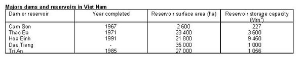 Table 1: Major dams and reservoirs in Vietnam. (Source: FAO)
 There are 3,500 small reservoirs and 650 large and medium reservoirs. Data on the major dams and reservoirs of Vietnam are presented in Table 1. These reservoirs are multipurpose: hydropower, flood control, navigation, irrigation, and fisheries.
Four large hydropower plants provide a total of 2,608 megawatts (MW): Thac Ba (108 MW), Da Nhim (160 MW), Tri An (420 MW) and Hoa Binh (1,920 MW). Approximately 200 small hydropower plants with a total capacity of 3.7 MW are in operation, as are numerous micro-hydropower plants with a total capacity of 30 MW. Seventy percent of electricity is generated by hydropower.
Water Withdrawal
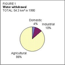 Figure1: Water withdrawal. (Source: FAO)
 The total annual water withdrawal for agriculture, industries, and domestic purposes was estimated at 54.3 km3 in 1990 (Figure 1). The total domestic demand in 1990 was estimated at 2.0 km3/year for both urban and rural consumers. This volume for domestic water use was estimated at 1.3 km3 in 1980 and is expected to reach 2.9 km3 by 2000. National industrial demand was 1.5 km3 in 1980, rising to 5.3 km3 in 1990. It is expected to reach 16.0 km3 in 2000. In 1980, agriculture used 35.0 km3 of water. In 1990, agricultural water withdrawal was estimated at 47.0 km3, or 86.5 percent of the total water demand, of which some 6.5 million m3 were for livestock. The estimated water demand for agricultural purposes for 2000 is 60.5 km3.
It is estimated that 1.46 percent of Vietnam's water demand is met by groundwater. The balance comes from surface water sources such as rivers, lakes, and reservoirs. Groundwater is mainly used for domestic water supply in urban areas.
To date, no treatment facilities have been available in plants, factories, and sewer systems before wastes are discharged into water bodies. In Hanoi, 300,000 m3/day of wastewater are discharged into the rivers.
Irrigation and Drainage Development
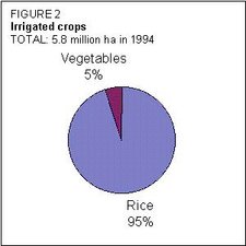 Figure 2: Irrigated Crops. (Source: FAO)
 Small indigenous irrigation systems have long been employed in Vietnam. Modern irrigation development stagnated until the reunification of the country in 1975.
Early post-1975 growth was in small and medium irrigation schemes, while in the period 1985-1990, growth was concentrated in large irrigation and multipurpose schemes. The total irrigated area expanded at a rate of 2.9 percent/year in the period 1980-87, while between 1988 and 1994 it was 4.58 percent/year.
In 1994, there were about 3 million ha of irrigated land in Vietnam. About 73 percent of this land, or 2.1 million ha, was devoted to rice with a cropping intensity of 2.6, giving an aggregate irrigated rice area of about 5.46 million ha. In addition, 0.3 million ha of irrigated area were devoted to subsidiary vegetable and industrial crops, giving a total annual harvested irrigated area of about 5.8 million ha (Figure 2).
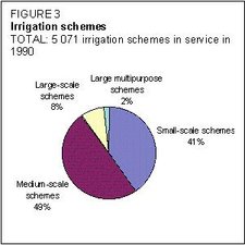 Figure 3: Irrigation schemes. (Source: FAO)
 It is estimated that by rehabilitating existing infrastructures in the Red and Mekong deltas, there is the potential to expand irrigation to some 700,000 ha. The overall irrigation potential in Vietnam is estimated at 6,000,000 ha.
In 1994, the actual irrigation capacity was just 70 percent of the 3 million ha of equipped area. Two-thirds of this area were in the two large deltas (37 percent in the Red Delta, and 27 percent in the Mekong Delta). In 1994, about 49 percent of the cultivated area was irrigated. In 1990, there were 5,071 irrigation schemes in operation (Figure 3).
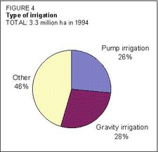 Figure 4: Types of irrigation. (Source: FAO)
 Of the total area irrigated in 1994, formal government schemes covered about 54.4 percent, equipped with pumped or gravity irrigation. The remainder consisted of private land irrigated by swing baskets, buckets, small private pumps, and, probably, small gravity diversions (Figure 4). This type of irrigation is concentrated in the Mekong Delta and, to a much lesser extent, in the Red Delta. Some 59 percent of the pump irrigation capacity is electrically driven, the remainder relying on oil-powered engines.
The drainage system covers over 1 million ha, mostly in the northern and central parts of the country, particularly the Red Delta.
The average aggregate yield for both irrigated and non-irrigated rice is 3.3 tons/hectare (t/ha), with the spring crop providing the highest yield of around 5 t/ha, and the summer crop providing the lowest yield of around 2.8 t/ha.
Irrigation fees were first established in 1984 in some provinces, such as Vinh Long. The fee for irrigation and drainage services represents about 4-8 percent of the total crop output. After remaining constant for a number of years, water fee collections rose in the 1986-1991 period with an average collection of 31.6 kilograms (kg) paddy/ha, while from 1992 to 1994, collections averaged 38.8 kg paddy/ha.
Institutional Environment
The Ministry of Water Resources (MWR) is the main body charged with setting policy, and responsible for the planning, management, and allocation of water resources at the central level. The MWR is responsible for constructing headworks and canals for schemes larger than 150 ha, while the provinces are responsible for developing smaller schemes.
Several divisions of the MWR are particularly important for agricultural water control. The Institute of Water Resources Planning prepares national plans, policies, objectives, and strategies for water resources management and development which are used as guidelines by the provinces. It also prepares prioritized lists of investment projects for consideration by the state planning committees.
The Office of Irrigation and Drainage Management oversees the management of irrigation and drainage structures, develops policy guidance, produces operations, and maintenance guidelines and collects data. It operates one national irrigation scheme in Dau Tieng, and interacts with other schemes through provincial or regional Irrigation and Drainage Management Committees and Provincial Peoples Committees.
The Vietnamese Hydraulic Investigation and Design Company is the technical design arm of the MWR.
The Construction Management Department, financially autonomous since 1994, develops procurement and construction management policies and guidelines for the water resources sector and monitors the activities of construction enterprises building MWR schemes.
There are a number of other institutions involved with irrigation planning and management, such as the Ministry of Science, Technology and Environment, which formulates environmental policies, which may include water-related issues.
The General Department for Meteorology and Hydrology undertakes surveying and hydrographic data collection and monitoring.
The Ministry of Energy manages electricity generation, transmission, and distribution for uses including irrigation pumping.
Trends in Water Resources Management
The Government has prepared plans and targets up to 2000. These plans indicate an accelerated growth rate of 4.5-5 percent for the agriculture sector. Other targets include: reducing the number of very poor people by 50 percent; reducing malnutrition among children to less than 30 percent; providing clean drinking water to all the urban population and 80 percent of the rural population. About 40 percent of the investment needed is projected to come from the Government, 15 percent from State enterprise and the rest from the private sector. The main items in the public investment program are transport and water supply (33 percent), and irrigation and agriculture (24 percent).
The Ministry of Agriculture and Rural Development (MARD) has prepared a program for rural development, which complements and builds on the strategy for the agriculture sector. The major objectives of this program are to raise incomes and living standards in rural areas; diversify the rural economy through increased production of high value crops; and conserve the natural resource base, particularly land and water.
For 2010, the main targets are to: raise gross domestic product (GDP) per capita in the rural areas to US$1,000, irrigate 80 percent of all cultivated land, increase forested areas, and raise food production to 40-45 million tons.
The World Bank irrigation rehabilitation project, being implemented since 1995, is funding the rehabilitation and completion of seven irrigation schemes comprising a total area of 130,000 ha. It is to be completed in five years at a total investment cost estimated at US$40 million.
The Mekong Delta water resources development project is expected to finance integrated water resources development, including irrigation, drainage, saline intrusion control, navigation, rural water supply, and agricultural diversification, in three geographical areas (South Manh Thit, Omon-Xano and Quanlo-Phunghiep) covering five delta provinces. The project is expected to start in late 1998, and the investment cost is about US$130-140 million.
The Red Delta water resources sector project provides US$75 million, financed by the Asian Development Bank, to rehabilitate or upgrade 20-30 small to medium-scale irrigation schemes in the Red Delta. The project is being implemented by the MARD and it is expected to be completed by 2000.
Further Reading
- Country Water Action: Vietnam, Asian Development Bank.
- Water Resources and Freshwater Ecosystems: Vietnam, EarthTrends.
- Wastewater Reuse in Agriculture in Vietnam: Water Management, Environment, and Human Health Aspects, Liqa Raschid-Sally, Wim van der Hoek, and Mala Ranawaka.
| Disclaimer: This article is taken wholly from, or contains information that was originally published by, the Food and Agriculture Organization. Topic editors and authors for the Encyclopedia of Earth may have edited its content or added new information. The use of information from the Food and Agriculture Organization should not be construed as support for or endorsement by that organization for any new information added by EoE personnel, or for any editing of the original content. |