Water profile of Suriname
Contents
Geography and Population
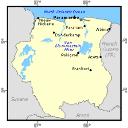
Suriname, located on the northeastern coast of South America, lies between latitudes 2° and 6° N and between longitudes 54° and 58° W. It is bordered by the Atlantic Ocean to the north, Guyana to the west, French Guyana to the east, and Brazil to the south. The country has an area of 163,270 square kilometers (km2), of which 80% is covered with tropical rain forests. Only 1.5 million hectares (ha) are considered suitable for agriculture. In 1997, the total cultivated area was estimated at 67,000 ha, of which 57,000 ha were annual crops, with rice being dominant, and 10,000 ha permanent crops, with bananas, plantains, coconut, citrus, and palm oil trees being the major crops. For administrative purposes, the country is divided into ten districts.
Suriname can be divided into four major ecological zones. The Young Coastal Plain, about 16,200 km2, consists of clay flats at sea level, covered in the estuarian zone with mangrove forests, coastal lagoons, and brackish swamps. It includes the delta systems which extend along the entire coast between the border River Maronwijne in the east and the Corantjin in the west. The width of the Young Coastal Plain varies from 8 kilometers (km) in the East to 50 km in the west. The Old Coastal Plain, about 4 300 km2, consists of remnants of 4 to 10 m high sandy ridges and clay islands, both covered with rain forests. These higher elements are surrounded by clay and peat soil, both at sea level, which are covered with freshwater swamps, swamp wood, and swamp forests.
The Savannah or Zanderij Belt, about 8,750 km2, 10 to 100 meters (m) above sea level, consists of rolling and dissected plains, characterized by unbleached loams and coarse white sands, both of continental origin. The vegetation consists of rain forests, xerophytic forests, and, to a lesser extent, open savannas. The Residual Uplands (interior), cover four-fifths (134,000 km2) of the land surface. This area is part of the Guyana Shield, with hills and mountains up to 1,230 m above sea level, and is mainly covered with undisturbed rain forests.
From a hydrographic point of view Suriname is not part of the Regional Amazon System because its territory is not part of the Amazon Basin. However, Suriname belongs to the Amazon Cooperation Treaty (ACT) because of vegetation, more specifically the tropical rain forest ecosystem in and around the Amazon Basin.
Suriname's population was 437,000 inhabitants in 1997, of which almost 50% are rural. The average density is estimated at 2.7 inhabitants/km2, but about 95% of the country's population live in the coastal plain, with the capital Paramaribo as the main urban center where approximately 70% of the population are concentrated (about 1,000 inhab./km2). On the other hand, residual uplands are sparsely populated, with just 5% of the total population (0.1 to 0.2 inhab./km2). Ninety percent of the country is uninhabited. The average annual population growth rate in the 1990-1997 period has been estimated at 1.2%. Agriculture contributed around 7% of Gross Domestic Product (GDP) in 1996, employed about 20% of the labor force in 1997 and is the primary source of livelihood in the rural areas.
Within the agricultural sector, rice has been the most important crop in the recent past, followed by bananas, vegetables, and fruits. Suriname's rice and banana exports have so far had preferential access to the European and CARICOM markets, a situation changed in the recent EU-ACP (Amazon Cooperation Treaty) negotiations.
Estuarine fisheries constitute a significant economic activity from a national point of view, although direct involvement of Suranimese citizens in the fisheries operations can be considered negligible. The major exports of Suriname in 1996 were bauxite and alumina (about 72%), shrimp and fish (11%), crude oil (3.5%), rice (8.0%), timber and bananas (1.5% each), and others (4.5%).
Climate and Water Resources
Climate
Suriname has a tropical climate. The populated area in the north has four seasons: a minor rainy season from early December to early February, a minor dry season from early February to late April, a major rainy season from late April to mid-August and a major dry season from mid-August to early December. Daytime temperatures in Paramaribo range between 23° and 31° C, with an annual average temperature of 27° . The range in average temperatures between the warmest month, September, and the coldest, January, is only 2° C.
Rainfall is highest in the central and southeastern parts of the country. Annual rainfall averages 1,930 millimeters (m) in the west and 2,400 mm in Paramaribo. The relative humidity is very high, from 70 to 90%.
Water Resources
Annual average rainfall in Suriname is 2,200 mm or 355 km3/year in the country's territory. It is considered that evapotranspiration and evaporation losses represent 49% of this precipitation. IRWR are about 88 km3/year. Suriname's major rivers flow northward into the Atlantic. The main characteristics of these rivers are detailed in the next table.
Major River Basins of Suriname
|
Table 1. Major river basins of Suriname River basin Catchment Area (including the catchment area outside the country) (km2) Discharge at the outfall (km3/year) Maroni 68,700 56 Commewijne-Cottica 6,600 4 Suriname 16,500 13 Saramacca 9,000 7 Coppername 21,700 6 Nickerie 10,100 6 Corantyne 67,600 50 Total 200,200 142 (Water profile of Suriname) |
|---|
Water Withdrawal
Water withdrawal in 1987 was 460 million cubic meters (m3), 6% in the domestic sector, 5% for industrial purposes and the remaining 89% for agriculture. Only surface water is used for agricultural purposes, while groundwater is used as drinking water because of its high quality and the relatively higher extraction cost. In urban areas, approximately 95% of the population has access to running water (90% by house connections) and only some 3% of the population has sewerage connections. In rural areas about 70% of the population has running water in the house. Typically, the sewage from individual houses in Paramaribo area is treated by septic tanks, causing problems of pollution during heavy rainfalls. A Master Plan for the expansion and structural improvement of the sewer system of Greater Paramaribo should be completed by 2001.
Lakes and Dams
Lake Blommestein Meer, located on the Suriname River, is the biggest lake in the country. There is one hydroelectric dam in the Suriname River at Atobakka. In the past, there were plans to use part of this water for agricultural purposes.
Irrigation and Drainage Development
Virtually all economic developments of significance have taken place in the deltas (Suriname-Commewijne, Coppername-Saramacca, and Corantijn-Nickerie). In the 17th century, Dutch settlers introduced practices for reclamation of tidal flood lands, converting large areas of the [[coast]al plain] into polders (e.g. an area of low-lying land that has been reclaimed from a body of water and is protected by dikes) suitable for the establishment of plantations for the production of staple products such as cotton, cocoa, coffee, and sugar. The design of water management systems that facilitated the economic utilization of the tidal movements for agricultural production constituted a prime concern in the spatial layout of the polders, established in the form of rectangles 50 to 1,000 ha in size. In the course of the 17-18th centuries, about 1,000 polders of this type were built. After the abolition of slavery in 1863, the human resources demand for plantation-production was met by laborers contracted in China, India, and Indonesia, that were entitled to obtain small plots of farmland. The replacement of the liberated slaves by Asian laborers led to the introduction of rice cultivation into the economic production structure of Suriname. By 1950 large-scale mechanized rice farming based on river diversion irrigation was introduced, with the execution of the Wageningen mechanized rice production development scheme in the District of Nickerie, subsequently followed by the gradual expansion of irrigated farmland on both sides of the Nickerie River to a total of approximately 50,000 ha by 1998. Currently, although the Government controls the largest farms and exports of rice, private farmers account for most of the harvest. Irrigation is mainly applied in the production of rice and banana. The major irrigation technique is surface irrigation, while sprinkler is only used in part of the banana irrigated area. According to the most recent statistics, the irrigated land in 1998 for rice was 49,350 ha and 1,830 ha for the banana crop, 858 of which by sprinkler irrigation. A very small number of farmers use localized irrigation.
Institutional Environment
The Ministry of Agriculture, Animal Husbandry and Fisheries is in charge of the irrigation and drainage management. Water supply systems in urban areas are operated under the supervision of the Suriname Water Company. The Water Supply Service of the Ministry of Natural Resources and Energy is responsible for water supply systems in rural areas. A number of urban and rural water systems are operated by private bodies or other government institutions. The establishment of a Water Supply Administration to protect sources of drinking water supply is under way. The Electric Utility Company of Suriname under the Ministry of Natural Resources and Energy is responsible for the generation and distribution of electricity. There is substantial self-generation of electricity among the industries. The largest self-producer, the Suriname Aluminium Company sells electricity to the Government under a long-term agreement signed in 1957 which expires in 2045. The Government resells the energy to the Electric Utility Company. The Hydrological Department of the Ministry of Public Works is in charge of flood control and mobilization of water resources. Government is compelled to define management plans for all actions in the coastal wetlands and the estuarine zones and it is expected that the entire Young Coastal Plain (deltas) will be designated as a multiple-use management area (MUMA). The Planning Act defines area-wise conditions to be taken into account with respect to land use and rational exploitation of the prevailing natural resources, as well as the prerequisites to be observed with respect to special management by, as well as on behalf of, the Government.
Trends in Water Resources Management
In the 1994-1998 Government's Multi-annual Development Plan, the revitalization of agriculture was emphasized through rehabilitation and modernization of the [[agricultural] sector], modernization of agro-industries, improvement in traditional export production, and expansion of non-traditional agro-cultural production. The policies focused on: (i) increasing and stimulating export oriented and import substitution activities; (ii) supporting agricultural activities in connection with sustainable measures against poverty; (iii) increasing of foreign exchange earnings; and (iv) implementing an investment program for rehabilitation of physical infrastructure and most-needed logistics for a limited number of priority sectors. In addition to the above, the 1996-2001 Agricultural Policy Document mentions certain policy measures, notably: removal of subsidies to agricultural parastatals, their privatization, incentives for export and domestic food production and improvement of physical infrastructure. Specific policies are geared towards: (i) sustained palm oil production to develop spearrot disease resistant hybrids and expand production; (ii) increased efficiency of the rice sector and reactivation of rice research to compete in the world market; and (iii) improved competitiveness and productivity of banana production. Programs to be implemented include, the improvement of statistical collection methods and irrigation and drainage. It is expected to increase the irrigated area by 16,000 ha in the period 1998-2010 and increase the area used for annual cropping by 30,000 ha. For vegetables and fruit, it is also necessary to improve access to information and marketing skills, including better conditions for air freight. The Multi-Purpose Corantijn Project in the district of Nickerie includes the construction of a 66 km irrigation canal to bring water to existing and projected new areas to produce an increased 12,500 ha of rice (paddy) and raise cropping intensity from 1.22 to 1.90. Vegetables, perennial fruit crops, and pastures are mainly rainfed, although modern irrigation and drainage systems are needed to make production less dependent on rainfall.
Further Reading
- FAO. 1997. Suriname. FAO Representative's Annual Report (January to December 1996). Paramaribo.
- FAO. 1996. Draft Strategy for National Agricultural Development. World Food Summit Follow-Up. Horizon 2010. Rome.
- Janssen, B. H. and Wienk J. F. 1990. Mechanized Annual Cropping on Low Fertility Acid Soils in the Humid Tropics. A Case Study of the Zanderij Soils in Suriname. Wageningen Agricultural University Papers. No. 90.5. The Netherlands.