Water profile of Republic of Korea
Contents
Geography and Population
The Republic of Korea is located in the semi-tropical area along the east coast of the Asian landmass. It is bounded by DPR Korea in the north, the Sea of Japan in the east, the Yellow Sea in the west, and is separated from Japan by the Korea Strait to the south and southeast. For administrative purposes, the country is divided into one metropolitan city (the capital Seoul), five extensive cities and nine provinces.
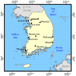 Map of Republic of Korea. (Source: FAO)
 The country has a total land area of 98,730 square kilometers (km2), which represents about 45 percent of the Korean peninsula. Some 65 percent of the land is mountainous, especially along the east coast with the highest point (Halla-san) at 1,950 meters (m) above sea level. The main mountains are the Taebaek range, which cross the country from north to south with their highest point at Mount Sorak (1,708 m), and the Sobaek range running from the southwest to the northeast, whose highest point is Chiri mountain (1,915 m). Thebplains are located mainly along the west and south coasts.
The cultivable area is relatively small and is largely spread along the southwest coast. Most of the cultivable area in the country has been reclaimed and is intensively cultivated. In 1996, about 1,176,000 hectares (ha), or 60 percent of the cultivated area, were cultivated, mainly with rice. About 10 percent of the cultivated area, or 198,443 ha, was occupied by permanent crops.
In 1996, the total population was estimated at 45,314,000 inhabitants. Due to the rapid industrialization of the country, the agricultural population decreased from 68 percent of the total in 1965 to 17 percent in 1996. The average population density is 457 inhabitants/km2. The highest population density is 17,289 inhabitants/km2 in Seoul and the lowest density is 284 inhabitants/km2 in Cheju province. The annual population growth rate was 1 percent in 1996.
The agriculture, forestry, and fisheries sectors produced 17,583,000 million won or about 6.5 percent of Gross National Product (GNP) in 1996 at the 1990 constant price (the average currency exchange rate of the Korean won to one US dollar in 1990 was 707.8), a much reduced contribution from the almost 40 percent of 1965. An average farm family earned an annual income 23,298,000 won in 1996, of which non-agricultural earnings constituted 32.1 percent. In 1996, 11 percent of the employed population was engaged in agriculture.
Climate and Water Resources
Climate
The country's climate is determined by its latitude and geography, and presents four distinct seasons. Wind and precipitation are largely affected by the surrounding Pacific Ocean in the south and the Eurasian landmass in the north.
The mean annual rainfall is 1,274 millimeters (mm), of which about 70 percent is concentrated during the summer months from June to September. The rainfall is evenly distributed over the country. The average annual precipitation is 1,300 mm in Seoul in the north, 1,100 mm in Taegu in the center, and 1,400 mm in Pusan in the south. Typhoons accompanied by heavy rainfalls during summer or early autumn often cause severe crop damage, as do the droughts before the beginning of the summer monsoon.
The mean monthly temperature varies from below freezing in winter to over 25 °C in summer. Frost-free days extend from around the end of April until mid-October, varying from 175 days a year in the north to 220 days in the south. Double cropping is practiced in the south.
River Basins and Water Resources
Most of the rivers flow west and south through the plains. There are five main drainage systems, which altogether cover two-thirds of the territory:
- the Han River basin in the northwest, with an average runoff estimated at 19.4 cubic kilometers per year (km3/year) and a drainage area of 26,018 km2;
- the Kuem River basin in the west, with an average runoff estimated at 6.2 km3/year and a drainage area of 9,810 km2;
- the Nag Dong River basin in the south, with an average runoff estimated at 13.9 km3/year and a drainage area of 23,817 km2;
- the Seom Jin River basin in the south, with an average runoff estimated at 3.8 km3/year and a drainage area of 4,897 km2;
- the Young San River basin in the south, with an average runoff estimated at 2.6 km3/year and a drainage area of 3,371 km2.
The total annual volume of surface runoff produced internally is estimated at 62.25 km3, while internal groundwater resources amount to approximately 13.3 km3. About 10.7 km3 of groundwater resources constitute the base flow of the rivers. Some transboundary rivers cross the border with DPR Korea. By analogy with the annual discharge of the Han River in DPR Korea (19.4 km3/year with a catchment basin four times that of the basin flow into the Republic of Korea), the inflow to the Republic of Korea from DPR Korea is estimated at 4.85 km3/year. The total average surface water discharge in the Republic of Korea is therefore estimated at 67.1 km3/year. Due to the intensive nature of the rainfall and the steeper natural channel slopes, about 37 percent of the annual water resources are flood runoffs, concentrated in summer. Out of the 64.5 km3 of river runoff, 47 km3 run off in flooding time. The total renewable water resources are estimated at 69.7 km3/year
Lakes and Dams
During the last 50 years, a considerable effort has been made to regulate the course of rivers. Multipurpose river basin schemes have been developed for flood control, irrigation, community water supply (Society and water resources), and hydropower production. In 1997, there were 765 dams of over 15 m in height. There are more than 18,000 small irrigation reservoirs. Man-made lakes account for 93 percent of all lakes in the Republic of Korea. The water storage for dams and reservoirs totals 16.2 km3.
In 1997, the total hydropower electricity generation amounted to 5,404 gigawatt-hours (GWh), representing 2.4 percent of the country's total electricity generation.
Non-conventional Water Sources
In 1996, total produced wastewater was estimated at 7,947 million cubic meters (m3). Only 4,180 million m3 were treated. A desalination plant has recently been installed at a steel-milling factory in the southeast. However, this has not been included in the water balance as its capacity is insignificant.
Water withdrawal
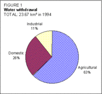 Figure 1. Water withdrawal. (Source: FAO)
 In 1994, the total water withdrawal for agricultural, industrial, and domestic uses was estimated at 23.7 km3/year (23.4 km3/year in 1975) (Figure 1). In addition, about 6,476 million m3 were withdrawn for river maintenance uses.
Rapid industrialization and economic growth have changed the pattern of water demand. Domestic and industrial water consumption increased steadily from 10 percent and almost 0 percent in 1975 to 26 and 11 percent respectively in 1994, while agricultural water consumption decreased from 90 to 63 percent in the same period.
Irrigation and Drainage Development
Irrigation development in Korea has a long history. Weirs (headworks) were built in the first century, and the first reservoirs were constructed in 390 AD. Historical records show that there were about 26,000 diversion weirs, ponds, and dikes for irrigation water supply in 1910.
Irrigation development in Korea (Figure 2) can be divided into three stages:
- stage I, before 1945, when numerous small-scale systems were constructed by mobilizing local technology;
- stage II, 1946-1961, when existing systems damaged by war were repaired;
- stage III, since 1961, when large-scale comprehensive agricultural development projects have been implemented. During this stage, the Government has invested large amounts from international loans for the development and rehabilitation of irrigation systems and for the improvement of technical, institutional, and social aspects of irrigation.
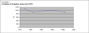 Figure 2. Evolution of irrigation areas since 1977. (Source: FAO)
 In 1982, the estimation of water requirements for irrigation was adjusted to cover the ten-year drought frequency, and an inventory of existing irrigation systems throughout the country was prepared to identify rehabilitation requirements. As a result, many systems with insufficient capacities were categorized for rehabilitation.
In 1996, approximately 76 percent of all paddy was under irrigation. The main irrigated crop is paddy rice. The potential irrigable area has been taken as the same as the total cultivated area, or 1,945,480 ha.
Installed irrigation systems cover approximately half of the cultivated area. However, most of the cultivated areas are irrigated by virtually any means during the critical crop periods when threatened by drought. Typically, in high valleys where irrigation systems are not economically viable, farmers irrigate by pumping water from rivers, streams, and reservoirs using small portable pumps or power tillers.
As fertile paddies can be more easily and economically developed in flat plains than hilly areas, more farmland and consequently the accompanying irrigation systems have been developed by reclaiming river plains and tidelands. This also partly explains why surface drainage predominates. It is difficult to find a large and shallow river-swamp left idle in Korea. Irrigation development along the west coast is often implemented as part of tideland reclamation.
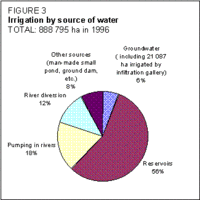 Figure 3. Irrigation by source of water. (Source: FAO)
 The main type of intake system is the reservoir. Reservoirs are used to store concentrated runoff during summer. Out of the total area of irrigated paddy of 888,795 ha, the area served by surface water is 770,917 ha, which consists of about 504,987 ha fed by 18,000 reservoirs, 159,987 ha by 6,000 pumping stations, and 105,943 ha by 18,000 headworks. The area irrigated by groundwater is 49,639 ha, using 15,156 tube-wells and 3,921 infiltration galleries (Figure 3).
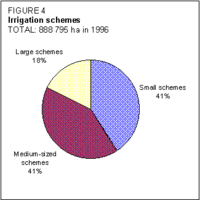 Figure 4. Irrigation schemes. (Source: FAO)
 Irrigation systems are classed as small (<50 ha), medium (51-3,000 ha), or large (>3,000 ha) (Figure 4). Using local government budgets, small systems are constructed by the cities or counties, and handed over to farmers' organizations for operation and maintenance (O&M). Medium-scale systems are funded from the central government's budget, constructed by the provinces, and handed over for O&M to Farmland Improvement Associations (FLIAs). Large systems are financed by the central government, executed by the Rural Development Corporation (RDC), and also handed over to FLIAs for O&M. There are some privately developed and owned irrigation systems, but no data on their area are available.
In any system, the full cost of construction is paid for by the Government. The farmers still provide labor for the final land leveling of paddies to avoid possible dissatisfaction or disputes over quality control. The cost of land acquisition is always paid for by the Government, and the farmers pay more than 6,000 won (US$7.72) per 0.1 ha of paddy as an annual fee.
The cost of irrigation development has increased sharply in recent years. This has largely been due to rising labor costs and land prices. The cost of developing conveyance systems down to secondary canals was approximately US$5,000/ha of irrigated area in 1989.
The major irrigated crops are paddy rice, vegetables and fruits. Winter barley is mostly sown on paddies after the rice harvest in autumn, and grown without irrigation during the winter with residual soil moisture until spring. Wheat and maize are seldom cultivated on irrigated paddy for economic reasons. The average yield of irrigated rice was 6.8 tonnes per hectare (t/ha) for single cultivation in 1996. The yields of other crops (partly irrigated) were 3.9 t/ha for wheat, 4.3 t/ha for winter barley and 4.0 t/ha for maize.
Institutional Environment
The main institutions involved in irrigation and drainage include the Ministry of Agriculture, Forestry. and Fisheries (MAFF), the RDC, the Federation of Farmland Improvement Association (FFIA), the FLIAs and the WUAs.
The MAFF, through the Rural Development Bureau (RDB), is responsible for policy, planning, and financing of all rural infrastructure projects, and for the supervision of local government institutions, the RDC, the FFIA, the FLIAs, and the WUAs.
The RDC is a semi-autonomous agency which carries out the planning, study, design, and supervision of the rural infrastructure projects in the country and overseas; the execution of large-scale agricultural development projects; the O&M of the important facilities of large-scale agricultural development projects; and the provision of O&M training courses for FLIA staff as well as engineering and administrative training courses for its own staff.
The FFIA is a public corporation which mainly carries out the planning, design, and supervision of the farmland improvement projects for farmland consolidation as well as providing guidance on the operational improvement of FLIAs.
There are 105 FLIAs in the country which are responsible for the O&M of public irrigation systems.
WUAs are organized by the farmers for the O&M of small irrigation systems which are not included in FLIA systems. The small systems are constructed and/or rehabilitated by the Government through the cities or the counties before being transferred to WUAs.
Trends in water Resources Management
Agricultural consumption of water is generally decreasing, while domestic and industrial consumption are increasing. However, peak irrigation water requirements are tending to increase because the extensive use of rice-transplanting machines has led to a reduced duration of the transplanting period in spring. Due to urbanization and industrialization, water consumption in and near cities and industrial sites is growing more rapidly. Water quality is deteriorating rapidly in the natural channels and reservoirs.
As the remaining development options become increasingly expensive, emphasis is being placed on the efficient use of water resources and on the rehabilitation and upgrading of existing systems. The need to save water resources and contain rising labor costs the installation of automatic control systems more feasible.
Further Reading
- Cho Hong-rae. 1996. Korea history of irrigation works. Korea National Committee on Irrigation and Drainage.
- Kim Dong-hak. 1993. The 2nd basic investigation of groundwater resources. IDP-94-1a, Report. Ministry of Construction and Transportation, Korea Water Resources Corporation.
- Lee Yun-sik. 1990. A report on long-term comprehensive plan of water resources (1991-2011). Korea Water Resources Corporation.
- Ministry of Agriculture, Forestry and Fisheries, Rural Development Corporation. 1995. Yearbook of land and water development statistics.
- Ministry of Agriculture, Forestry and Fisheries, Rural Development Corporation, & Institute of Agricultural Science and Development, Seoul National University. 1993. Modelling and optimization of rural water resources systems (III).
- Ministry of Agriculture, Forestry and Fisheries, Rural Development Corporation. 1996. Report on overcoming drought in Korea.
- Ministry of Agriculture, Forestry and Fisheries, Rural Development Corporation. 1983. A safe supply plan of agricultural water.
- Ministry of Agriculture, Forestry and Fisheries. 1995. Statistical yearbook of agriculture, forestry and fisheries.
- Ministry of Agriculture, Forestry and Fisheries. 1995. Status of wells and pumping facilities.
- Ministry of Construction and Transportation. 1992. Yearbook of construction statistics.
- Ministry of Construction and Transportation. 1994. A study on water recycling system.
- Ministry of Construction and Transportation. 1995. Report of groundwater management investigation.
- Ministry of Environment. 1995. Environmental statistics yearbook.
- Ministry of Environment. 1995. Environmental white paper.
- Ministry of Health and Welfare. 1995. Yearbook of health and welfare statistics.
- Ministry of Home Affairs. 1995. Yearbook of land register statistics.
- National Statistical Office. 1995. Korea statistical yearbook.
- Park Yong-dae. 1991. Climatological standard normal of Korea. Volume II. Korea Meteorological Administration.
- Shu Jae-myung. 1993. Water resources prospect for the 21st century. IPD-93-2, Research Report. Ministry of Construction and Transportation, Korea Water Resources Corporation.
| Disclaimer: This article is taken wholly from, or contains information that was originally published by, the Food and Agriculture Organization. Topic editors and authors for the Encyclopedia of Earth may have edited its content or added new information. The use of information from the Food and Agriculture Organization should not be construed as support for or endorsement by that organization for any new information added by EoE personnel, or for any editing of the original content. |