Water profile of Namibia
Contents
- 1 Geography, Climate, and Population
- 2 Economy, Agriculture, and Food Security
- 3 Water Resources and Use
- 4 Irrigation and Drainage Development
- 5 Water Management, Policies, and Legislation Related to Water Use in Agriculture
- 6 Environment and Health
- 7 Perspectives for Agricultural Water Management
- 8 Further Reading
Geography, Climate, and Population
Namibia lies along the southwestern coast of Africa, and is bordered by Angola in the north, Zambia and Zimbabwe in the northeast, Botswana to the east, South Africa in the south, and the Atlantic Ocean to the west. It occupies an area of 824,290 square kilometers (km2). Its north-south extent is about 1300 [[meter|kilometers] (km), while it measures between about 450 and 900 km from east to west, excluding the Caprivi Strip panhandle in the northeast. The highest point is the Konigstein with an altitude of 2,606 meters (m).
The country is divided into three topographical regions:
- The [[coast]al] desert region, which includes the Namib Desert and follows the entire length of the coastline. This area is composed of mobile dunes, gravel, and sandy plains.
- The inland plateau region, which is a continuation of the South African Plateau and stretches from the southern to the northern border and covers more than half of the country. It contains the isolated massifs of the Tsaris Mountains in the southwest, the Anas Mountains in the central area and the Erongo Mountains in the west. This plateau comprises mountains, highland areas and the Great Western Escarpment.
- The dune- and grass-covered Kalahari Desert to the east and south of the inland plateau region. This area is covered by sand of different thicknesses.
The three main vegetation regions are:
- Savannah, covering about 64 percent of Namibia’s land surface.
- Desert vegetation, covering about 16 percent.
- Dry woodlands, covering about 20 percent of the land.
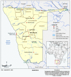 Map of Namibia. (Source: FAO)
 The cultivable area is estimated to be 25 million hectares (ha). In 2002, the cultivated area was 820,000 ha, of which 816,000 ha arable land, while 4,000 ha were under permanent crops, accounting together for about 1 percent of the total land area of the country and 3 percent of the cultivable area (Table 1).
Namibia’s climate is characterized by hot and dry conditions and sparse and erratic rainfall. Within Africa the climate is second in aridity only to the Sahara Desert and 92 percent of the land area is defined as hyper-arid, arid or semi-arid. Rainfall patterns are characterized by their high temporal and spatial variability. Conventional statistical descriptors such as mean and even median are often difficult to use and estimates of rainfall characteristics and patterns based on point measurements are problematic.
Mean annual rainfall is estimated to be 285 millimeters (mm). Of the total rainfall, 83 percent evaporates, 14 percent is used up by vegetation, 1 percent recharges groundwater and only 2 percent becomes runoff and may be harnessed in surface storage facilities. Net evaporation can be as high as 3,700 mm per year. In the [[coast]al] plateau the average monthly evapotranspiration always exceeds the rainfall by a factor of up to five. The coastal region is an arid desert less than 300 meters (m) above sea level. Along the coastal belt, precipitation from advective fog exceeds precipitation from rainfall.
Mean annual temperatures are below 16 °C along the southern coast, between 20 °C and 22 °C in large parts of the country’s interior and the eastern parts, and above 22 °C in the north. Temperatures are moderated by the cold Benguela currents along the coast. In Windhoek average temperature ranges are from 6 °C to 20 °C in July to 17 °C to 29 °C in January.
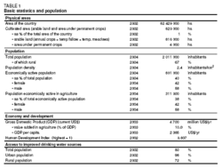 Table 1. Basic statistics and population. (Source: FAO)
 The country’s population is about 2 million (2004), with an annual growth rate of 2.1 percent (Table 1). Of the total population, 67 percent are rural. Namibia is one of the world’s most sparsely populated countries with a population density of 2.4 inhabitants/km2. Wealth distribution is highly inequitable, and there is a high incidence of extreme poverty. In 1998, 10 percent of the population received 65 percent of income leaving only 35 percent for the remaining 90 percent. Subsistence farmers and livestock herders, who earn their livelihoods in extremely harsh and stressful conditions account for 70 percent of the population. The unemployment rate is 40 percent. In 2002, 98 percent of the urban and 72 percent of the rural population were using improved drinking water sources; coverage is 80 percent at the national level (Table 1).
Economy, Agriculture, and Food Security
Namibia’s Gross Domestic Product (GDP) was US$4,700 million in 2003. The value added by agriculture was 10 percent of GDP, of which 75-80 percent are attributed to livestock farming. The sector provides occupation for 38 percent of the economically active population and 58 percent of the population working in agriculture is male.
Agriculture is segmented in two very different sectors:
- The commercial sector, with around 4,000 mostly white freehold farmers concentrating on livestock.
- The communal sector, mainly in the north, supports around 140,000 families. It is characterized by low levels of agricultural productivity, high incidences of poverty, food insecurity, lack of appropriate farming methods, and high unemployment levels. Farmers in communal areas engage in rainfed crop and livestock production, making the sector vulnerable to climatic variability, which is reflected in the high variability of output from one year to another; the sector is further constrained by poor marketing initiatives. Access to land is governed by custom, which contributes to a low level of technology and output due to lack of official ownership, which hampers access to funding.
Growth in the agricultural sector has averaged 1.2 percent per year since independence in 1988, while since 1993 growth has averaged 2.8 percent per year. The sector is strongly influenced by climatic conditions and as a result the contribution to GDP has varied between 6.8 percent and 12.3 percent since 1990, with low contributions in drought years. Since 1995, agricultural growth has barely kept pace with population growth, which can be attributed directly to the below-average rainfall in Namibia over the past few years. As a result of low rainfall there was considerable destocking of livestock in 1996, which led to a 60 percent drop in the number of cattle marketed in 1997. Cereal production has been similarly affected. Growth in the agricultural sector is expected to be weak in the coming years, implying negative per capita growth. Food imports amount to about 7 percent of the total value imports. Namibia imports sugar, maize, edible offal, wheat, concentrated milk and cream, cheese, and butter. Agricultural exports comprise mainly livestock and meat products and account for about 15 percent of all Namibian exports.
The value added per cubic meters (m3) of water in irrigation is very low compared to manufacturing and service sectors, about US$1.20/m3 compared to U$44/m3 and US$93/m3 respectively.
Water Resources and Use
Water Resources
The main river basins in Namibia are:
- The Zambezi River Basin with a basin area of 17,426 km2 in Namibia is the country’s richest water source. The Zambezi has a mean flow of 40 km3/yr and in the northeastern Caprivi strip forms the border between Zambia and Namibia for about 100 kilometers (km) and over a short distance between Zimbabwe and Namibia.
- The Okavango River basin is an interior basin with an area of 106,798 km2 in Namibia. The river rises in Angola, then, flowing in a narrow alluvial plain up to 6 km wide, forms the border with Namibia for some 350 km before crossing the Caprivi Strip and flowing into Botswana, where it forms the Okavango Swamps. Its mean flow is slightly above 10 km3/yr. It has two major tributaries, the Cubango and the Cuito. While the flow in the Cubango River upstream of the Cuito River confluence drops to very low levels during dry years, the flow from the Cuito River is more reliable. A Namibian tributary of the Okavango is the Omatako River, which contributes no flow at all. Originating in the dry interior of Namibia, there is no evidence that the Omatako has ever flowed further than 400 km from its source.
- The southwest coast basin including the Kunene River covering an area of 17,549 km2. Rainfall over the Kunene catchment is unreliable and variable, and the mean flow of the river is 5 km3/yr. The relatively small catchment area and steep river bed slope in the upper section also mean that flows run relatively quickly to the coast, leaving the river almost dry at the end of the dry season. With the inception of the Ruacana hydroelectric scheme and its associated storage dams, flows should have become more regulated; this did not happen because the Gove Dam in Angola has never been adequately operational. In addition to being used to generate hydropower, the Kunene also supplies a significant amount of water to the four northern regions of Namibia, where approximately 700,000 people or over one third of the total population live. The demand is at its peak in October, which corresponds with the period of minimum flow in the Kunene.
- The south Atlantic coast including the Huab, Ugab, Omaruru, Swakop, and Kuiseb Rivers with a total area of 264,160 km2.
- The Orange River Basin has an area of 219,249 km2 in Namibia. The river forms the southern border of Namibia with South Africa over a distance of approximately 600 km. It has a mean flow of about 11 km3/yr. The major Namibian tributary, the Fish River, has a mean flow of 0.48 km3/yr at its confluence with the Orange River. The flow in the lower parts of the Orange has been cut by nearly two thirds, especially over the last 35 years since the start of the Orange River Project (ORP) in South Africa. This project transfers water from the Caledon and Orange Rivers to rivers outside of the basin that flow towards cities in the Eastern Cape Province in South Africa. In order to operate the ORP there are more than a dozen dams with a combined capacity of 8.5 km3. The key structure in this development is the in 1979 completed Gariep Dam, previously known as the Hendrick Verwoerd Dam, with a reservoir capacity of almost 5.7 km3.
- The interior basins, including the Cuvelai River basin and part of the Kalahari desert, cover an area of 199,718 km2; The Cuvelai River enters Namibia as a 130 km wide delta of ephemeral watercourses, known as oshanas, which then converge to terminate in the Etosha Pan. Runoff in the Cuvelai is erratic and has been observed to vary from no flow to 0.1 km3/yr, as was gauged in 1995. Due to flat topography and shallow saline groundwater, surface water storage facilities are limited to shallow earth or excavation dams, which suffer from high evaporation rates.
The percentage of mean annual precipitation that ends up as river flow in ephemeral systems in Namibia varies from as little as below 1 percent up to around 12.5 percent for parts of the Fish River basin. The remainder goes to direct evaporation and evapotranspiration, with the latter being by far the greatest component. Some of the runoff recharges alluvial aquifers on its way downstream, and in so doing the majority of ephemeral river floods ultimately disappear entirely into the sand. Namibia’s ephemeral rivers are "effluent" systems. This means that the river feeds the groundwater table, rather than having its flow sustained by a high groundwater table, as is the case with "influent" rivers.
Namibia’s groundwater occurs in a wide range of rock types making groundwater management a complex process. It provides a buffer against drought in many [[region]s] of the country, but it does remain inherently vulnerable to overabstraction and pollution. Aquifers occurring in Namibia are classified as alluvial, Kalahari, fracture, Karst or artesian aquifers. Parts of the Grootfontein-Otavi-Tsumeb Karstland aquifer have been subject to thorough investigations and modeling, and for the Otavi Mountain Area the following recharge conditions were identified:
- The recharge rate amounts to 2 percent of the long-term mean annual rainfall after a sequence of rainy seasons in each of which the long-term annual rainfall is exceeded;
- The recharge rate amounts to 1 percent of the long-term mean annual rainfall after a single rainy season in which the long-term mean annual rainfall is exceeded;
- The recharge rate amounts to 0 percent if the rainfall does not exceed the long-term mean annual rainfall.
Although the ephemeral [[river]s] of Namibia have dry sandy or [[rock]y] river beds for most of the year, they are conduits for subsurface flow and contain a number of wetlands defined as "shallow, swampy or marshy areas with little or no water flow" or "waterlogged solid dominated by emergent vegetation". In Namibia this description applies to most sections of all westward flowing rivers north of the Kuiseb River. Wetlands are periodically used for hunting and seasonal fishing. Currently, their utilization includes communal domestic stock farming, small mining enterprises and small-scale gardening. The ecology of Namibia’s wetlands is very fragile. Over-exploitation of alluvial aquifers and the building of dams, especially on the Kunene River and the Orange River, which reduce the flow downstream are potential threats to those wetlands that depend on them. The protection and conservation of wetlands is therefore an important priority and the government of the Republic of Namibia has initiated several efforts towards ensuring this. Wetlands of international importance in Namibia, and Ramsar sites, are the Etosha Pan, the Orange River Mouth, Sandwich Harbour, and Walvis Bay.
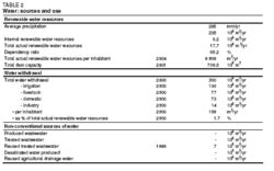 Table 2. Water:sources and use. (Source: FAO)
 Total natural renewable water resources of Namibia are estimated at 45.46 km3/yr, of which only 6.16 km3/yr are internally produced (Table 2). Over half of the external water resources comes from the Zambezi River, while smaller amounts are contributed by the Orange, Kunene and Kwando rivers and [[river]s] from the Okavango. From the total accounted natural flow of the border rivers Zambezi, Kunene and Orange of 28 km3/yr, only 0.255 km3/yr is under agreement (0.07 from the Orange River and 0.185 from the Kunene River) and should thus be considered as actual flow. This reduces the natural renewable water resources of 45.46 km3/yr to actual renewable water resources of 17.715 km3/yr.
A number of ephemeral [[river]s] have been tapped by building dams. The total storage capacity of the major dams is about 0.71 km3 and their 95 percent assured combined yield is 95.83 million m3/yr. In addition to these larger reservoirs, there are thousands of small farm dams scattered around the ephemeral river basins.
The total assured safe yield of Namibia’s water resources is 660 million m3/yr, distributed as follows: groundwater 300 million m3/yr, ephemeral [[river]s] 200 million m3/yr, perennial rivers 150 million m3/yr and unconventional sources 10 million m3/yr.
Treated wastewater is used more and more often for applications that do not require drinking water quality, such as landscape irrigation. It was found that the return flow in Windhoek and urban centers equals 40 percent of freshwater consumption and can be reused after treatment. Reuse of water is practised in Namibia in many urban areas such as Swakopmund, Walvis Bay, Tsumeb, Otjiwarongo, Okahandja, Mariental, Oranjemund, and Windhoek. In Windhoek, 1.14 million m3 of treated effluent were used for irrigation in 1997 and reclamation of water for potable reuse has been practiced since 1968. The plant could supply 8,000 m3/day, which was about 19 percent of the average daily water demand of the city in 1997. A new reclamation plant with an increased capacity of 21,000 m3/day was completed in 2002, and the old plant will in future be used for reclaiming irrigation water. Wastewater recycling is practiced by a number of mines. It is estimated that in the future 7 million m3/yr from Windhoek and 10 million m3/yr from other centers could potentially become available.
Recently a contract for the design and construction of a [[coast]al] desalination project was tendered.
Water Use
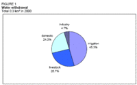 Figure 1. Water withdrawal. (Source: FAO)
 Total water consumption in Namibia was 300 million m3 in 2000 (Table 2 and Figure 1). Agriculture was the largest water user accounting for 213 million m3, of which 136 million m3 for irrigation (45 percent of total) and the remaining 77 million m3 for livestock (26 percent). The domestic sector followed with 73 million m3 (24 percent) and industry with 14 million m3 (5 percent).
The highest consumption of irrigation water was in the Fish and Orange River Basins with 41.5 and 41.0 million m3 respectively. In 2000, 30 million m3 of groundwater were used for irrigation, which is 22 percent of the total consumption of irrigation.
International Water Issues
Namibia shares the following perennial [[river]s] with five riparian states:
- The Orange River with Botswana, Lesotho, and South Africa in the south of the country with a mean annual runoff (MAR) of 11 km3 at Noordoewr. The existing agreed abstraction is 70 million m3/yr, and estimated actual abstraction was 36.2 million m3 in 1996 and 48.8 million m3 in 1999.
- The Kunene River with Angola in the north to northwest of the country, with a MAR of 5 km3 at Ruacana. The existing agreed abstraction is 185 million m3/yr. Estimated actual abstraction was 51 million m3 in 1996 and 23 million m3 in 1999.
- The Okavango River with Angola and Botswana, with a MAR of 5.5 km3 at Rundu and 10 km3 at Mukwe. The estimated abstraction at Rundu, without an agreement in place at present, was 27 million m3 in 1996 and 21.5 million m3 in 1999.
- The Kwando River with Angola with a MAR of 1.3 km3 at Kongola. Estimated actual abstraction in 1996 was minimal.
- The Zambezi River with Angola, Botswana, Malawi, Mozambique, the United Republic of Tanzania, Zimbabwe, and Zambia with a MAR of 40 km3 at Katima Mulilo. Estimated abstraction, without an agreement in place at present, was 2.3 million m3 in 1996 and 6.4 million m3 in 1999.
A number of ephemeral [[river]s], such as the Auob and Nossob cross into Botswana and South Africa, but their flows are so irregular that their importance as shared surface water sources is not significant. Groundwater flow in eastern Namibia is generally in an eastern direction, but no attempt has been made to quantify this flow and it has not been raised as an issue of shared resources.
Namibia is highly dependent on its neighboring countries for securing its water supply, particularly South Africa and Angola due to the large portion of the country’s population living near or along the banks of the [[river]s] shared with these countries. It is estimated that shared rivers currently provide around one third of the water consumed in Namibia. Total abstraction from the shared perennial rivers in 1999 was estimated at almost 100 million m3. To ensure good cooperation with its neighbors, Namibia has developed a regulatory framework, facilitates the establishment of a Basin Management Committees and is reviewing all agreements signed during pre-colonial and post-colonial times. The process of setting up a structure for dealing with shared water issues is in an advanced stage.
Some of the existing agreements and commissions between Namibia and its neighbors as related to internationally shared water resources are:
- The Permanent Joint Technical Commission (PJTC) between Angola and Namibia on the Kunene River Basin was established in 1990. Its current major priority is the development of a hydroelectric power scheme on the lower Kunene River.
- The Joint Operating Authority between Angola and Namibia was reinstated in 1990. It deals specifically with the operation of the regulating dam on the Kunene River at Gove (Angola), and with the infrastructure for the Ruacana hydropower station on the same river in Namibia. The power station itself is in Namibia, but part of the infrastructure (diversion weir, intakes) are situated in Angola.
- The Joint Permanent Water Commission (JPWTC) between Botswana and Namibia concerning the development and utilization of water resources of common interest was established in 1990, after the countries had cooperated on a technical level since the early 1980s. It has jurisdiction over activities in the Kwando-Linyanti-Chobe System in the Zambezi River Basin and had jurisdiction over the Okavango River before OKACOM was formed.
- The Permanent Okavango River Basin Water Commission (OKACOM) between Angola, Botswana, and Namibia was established in 1994 and oversees developments in the Okavango basin.
- The Permanent Water Commission (PWC) between Namibia and South Africa was established in 1992 to deal with water matters of mutual concern. Since the re-integration of Walvis Bay into Namibia in 1994, the Commission has concentrated its activities on the Orange River Basin.
- The Treaty of the Vioolsdrift and Noordoewer Joint Irrigation Scheme between Namibia and South Africa was also signed in 1992, establishing a parastatal authority to operate the irrigation project located on both sides of the Orange River at Vioolsdrift and Noordoewer.
Namibia has either signed or ratified numerous international protocols and conventions concerning water, notably those designed to protect the environment, including: i) the Zambezi River System Action Plan (ZACPLAN); ii) the UN Convention on the Law of the Non-Navigable Uses of International Watercourses; iii) the International Convention on Wetlands (Ramsar); iv) the SADC Protocol on Shared Watercourses. Another multinational agreement with a bearing on water matters is the Southern African Regional Commission for the Conservation and Utilization of the Soil (SARCCUS) established in 1948 with Angola, Botswana, Lesotho, Malawi, Mozambique, Namibia, South Africa, and Swaziland as members. One of its components was the Standing Committee for Hydrology.
Irrigation and Drainage Development
Evolution of Irrigation Development
Irrigated crop production has been practiced since soon after the arrival of the first European settlers, mainly on a small scale. The Noordoewer Scheme on the Orange River was established during the 1930s. The main State investment in irrigation was in the Hardap Scheme that became operational in the late 1960s. The Isisi Scheme on the Zambezi started in the 1980s, while the Etunda Project on the Kunene became operational in 1995/96.
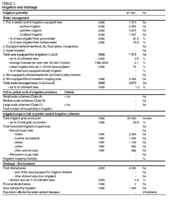 Table 3. Irrigation and drainage. (Source: FAO)
 In 2002, 7,573 ha were equipped for irrigation (Table 3). The main irrigated areas are:
- The Hardap Scheme, supplied from the Hardap Dam. Equipped area is about 2,260 ha;
- Schemes along the Orange River (such as Noordoewer Scheme, Aussenkehr Scheme). Equipped area is about 2,000 ha;
- Schemes along the Okavango River (such as Shadikongoro Scheme) with about 1,350 ha equipped area, of which about 600 ha are upstream of the confluence with the Cuito River, and about 750 ha are downstream of the junction;
- The Etunda Scheme on the Kunene River with about 640 ha equipped area;
- Schemes on the Zambezi River, like the Katima Farm (approximately 200 ha) and the Isisi Scheme (36 ha, currently not operational).
In addition to that, flood recession cropping (mainly maize) is practiced in the flood plains of the Okavango and Zambezi rivers; in 1992, this activity covered 2,000 ha.
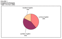 Figure 2. Irrigation techniques. (Source: FAO)
 No recent information on areas under different irrigation methods is available. In 1992, 2 950 ha were under surface irrigation (basin and furrow), 1,845 ha were under center pivot and sprinkler and 1,347 ha under drip or micro-sprinkler. New developments favor the use of sprinkler irrigation technologies and at present the figures are estimated to be 2,950 ha, 3,276 ha and 1,347 ha respectively (Table 3 and Figure 2). Irrigation methods practiced in some of the major schemes are:
- Hardap Scheme: mainly surface and sprinkler, some farmers are changing to drip;
- Noordoewer Scheme: mainly flood irrigation;
- Etunda Scheme: surface irrigation (day) and center pivot irrigation (night);
- Shadikongoro Scheme: center pivot;
- Isisi Scheme: flood irrigation (paddy rice).
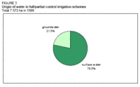 Figure 3. Origin of water in full/partial control irrigation schemes. (Source: FAO)
 The majority of the irrigation schemes use surface water. About 78 percent are estimated to be irrigated from surface water, the remaining from groundwater (Figure 3). It is estimated that irrigation water is pumped to 79 percent of the equipped areas.
There are four basic categories of farming in the irrigation sub-sector:
- Smallholders, generally on 1 ha plots, receive substantial government support, with free extension support, water and inputs, including land preparation;
- Medium-scale commercial farmers have been settled on 30 ha blocks and are able to obtain safe loans from the government through the Land Bank;
- Large-scale commercial farms are the major participants in the sub-sector and consist of private landowners who have undertaken irrigation on their own account, albeit often with support from the government;
- Parastatal or state farming, carried out by the National Development Corporation (NDC). These farms are commercially operated as State Farms, with management and paid labor. Several schemes under the NDC have been settled by farmers on 3 to 4 ha plots. The NDC manages and provides inputs to farmers as credits under soft loans. Any new government development is normally executed by the NDC.
Role of Irrigation in Agricultural Production, the Economy, and Society
No recent information on irrigated crops is available. In 1991, the major irrigated crops were maize, alfalfa and pasture, wheat, and cotton (Table 3). Irrigated land areas may be characterized by low-value crops such as wheat, maize, and alfalfa, and high-value crops including grapes, dates, cotton, and melons. The bulk of irrigated areas is under low-value crops. Currently irrigation development is taking place along the Orange River for the production of table grapes for the European and USA markets.
No nationwide study of the costs and benefits of irrigation is available. However, for example, the water supply in Hardap is heavily subsidized, rather than being charged for at an economic] rate, or the irrigation projects are not economically viable.
One constraint to some of the areas with large irrigation potential is that markets are far away:
- In the case of the Orange River area, Windhoek and Capetown are both about 800 km away, although the area lies adjacent to the main Namibia-South Africa road;
- In the case of the Zambezi area, Windhoek or Walvis Bay are about 1,300 km away;
- The Kunene basin is a remote and isolated area.
No monitoring system for water used per crop is in place, and the efficiency with which water is used in irrigation is generally not measured. Thus, farmers are not encouraged to invest in high-value crops, which Namibia imports heavily. Water used in subsistence agriculture seems to be more productive than in the commercial sector.
Status and Evolution of Drainage Systems
It is estimated that in 2003, about 2,000 ha were drained with subsurface drains. It is known that there are problems with the drainage system in the Hardap scheme, where the subsurface system has become blocked and the surface drainage canals and riverbed have become infested with reeds (Phragmites australis), which block the flow during floods, causing a severe problem.
Water Management, Policies, and Legislation Related to Water Use in Agriculture
Institutions
A number of institutions are responsible for different aspects of water supply, management, and use, including government departments, parastatal institutions (such as municipalities and community-based Water Point Committees), private organizations, and individuals.
Three key institutions involved are:
- NamWater, a parastatal institution that is responsible for bulk water supply;
- The Department of Water Affairs (DWA) within the Ministry of Agriculture, Water and Rural Development, which is responsible for all water resource development projects, including irrigation planning and development;
- The National Development Corporation (NDC) that executes new government developments and also manages schemes.
Water Management
Government policy is that so-called "irrigation scheme management boards" should be established to take over ownership and responsibility for irrigation scheme infrastructure. Management agreements would be established for each scheme.
A Joint Irrigation Authority between Namibia and South Africa, known as the Noordoewer/Viooldrift Irrigation Board, was established 1993. This board only covers irrigation schemes along the Orange River. In the Etunda scheme, lack of continuity in proper management and discipline is evident, leading to poor performance and maintenance. In the Shadikongoro scheme there was a lack of a clear understanding between project management and the local authority. This led to continuous interference by the local authority and resulted in unrest amongst the workers on more than one occasion. Eventually the farm manager was removed and since then, with proper management in place, the project seems to be coping financially and good yields have been achieved.
Decentralization is a national policy and thus responsibility for rural water supply is being transferred to the regional level through the establishment of Water Point Committees (WPCs) in the communal areas of Namibia. In total 3,673 WPCs are needed. By 1997/1998, 1,703 (or 46 percent) of those had been established. It is hoped that by 2007 complete community-based management of the water points will have been achieved.
Finances
According to the Water and Sanitation Sector Policy (WASP) of 1993, water supplied for irrigation by the State is to be charged at an economic rate, which may be reduced through a special subsidy. In the Hardap irrigation scheme, for example, NamWater supplies unprocessed water to farmers at a tariff of US$0.005/m3.
Full cost recovery in the water sector represents one of the major challenges for the water sector. Opposition to water pricing is widespread in Namibia and subsidies for water consumption still exist in many sectors, and particularly in the irrigation sector.
Policies and Legislation
According to Article 100 of the Constitution of the Republic of Namibia, "Land, water and natural resources below and above the surface of the land...of Namibia shall belong to the State if they are not otherwise lawfully owned".
The Water Act 54 of 1956 has a colonial origin and applies to Namibia the riparian principles of well-watered European countries. It is not only outdated but also, and above all, inconsistent with the country’s hydrologic reality. It predicates the right to water through ownership of riparian land and thus effectively excludes non-landowners, particularly in the rural areas, from having adequate access to water. The Government of Namibia is currently in the process of drafting the blueprint for a new Water Act for Namibia to replace the Water Act 54 of 1956. The draft of the new legislation includes:
- The establishment of a Water Advisory Council as the nation’s supreme advisory authority in water resources matters;
- The establishment of units of water resources governance at the river-basin level, with broad-based stakeholder representation;
- The creation and regulation of Water Users’ Associations (WUAs) for the management of rural water supply services;
- The formation and periodic review of a National Water Master Plan.
Legislation on irrigation in Namibia has been in draft form since 1993. Two main constraints are impeding progress. On the one hand, the government lacks the capacity to draft legislation which is in line with existing national and neighboring country legislation. On the other hand, massive investment is needed to upgrade existing irrigation scheme infrastructures to levels that users could be expected to assume responsibility for.
The National Agricultural Policy of 1995 has the following guidelines relating to irrigation:
- To improve regional irrigation performance through improved economic efficiency.
- To ensure that future irrigation development should be socially and economically viable.
- To minimize direct government intervention and investment in present and future irrigation development, thereby reducing the government’s financial burden within the sector. This should not however exclude the government from providing major, general infrastructural investment.
- To create an enabling atmosphere, whereby the non-government sector is encouraged to invest in irrigation development and manage their own operations.
- To establish the principle that the water user, rather than the government, pays for irrigation operation and maintenance.
- To encourage and support development of the informal irrigation sector, bearing in mind the need to limit direct government financial intervention.
- The government to provide sound national planning, monitoring, and evaluation of irrigation development.
- To provide sound extension to irrigators, especially smallholders.
- To encourage the participation of women at all levels of the irrigation sector.
- To ensure that future irrigation development is environmentally sustainable.
- To ensure adequate health standards on irrigation schemes.
- To ensure close regional cooperation in future irrigation development.
The Namibia Water Corporation Act 12 of 1997 (also known as NamWater Act) stipulates the objectives of NamWater.
In 1998, the Government of Namibia launched a major review of current water resource management practices, approaches, and policies through the Namibia Water Resources Management Review, with the long-term objective of achieving equitable access to, and the sustainable development of, water resources by all sectors of the national population.
The National Water Policy was adopted in 2000 and paved the way for the implementation of integrated water resources management.
Environment and Health
A variety of environmental problems are experienced in Namibia’s irrigation schemes. While no figures exist as to the extent of these problems, anecdotal evidence suggests that most are small-scale and manageable. Environmental problems include soil salinity problems in the Hardap and Aussenkehr Schemes, siltation of and reed growth in canals and weed invasion in the Hardap Scheme, soil compaction and runoff problems at the Shadikongoro farm in the Okavango Region.
Apart from the above, good drainage and/or good quality water leave most schemes trouble-free. For example, although the Naute Scheme’s soils are saline, water quality and drainage are good and so leaching effectively deals with salinity. On small-scale groundwater irrigation schemes, it is often found that boreholes with sufficient pressure for irrigation tend to be those with good quality water, and vice versa.
Perspectives for Agricultural Water Management
Given the water scarcity of Namibia, it is natural that there is competition for water. According to the WASP of 1993, the first priority for water allocation should be accorded to domestic use, while irrigation has second priority together with mining and industry. It was also proposed that irrigation should be regarded as an interim use until the water is used for higher value consumption with higher economic returns.
While most irrigation problems are technically manageable, in terms of dealing with proximate causes (such as excessive use of water and lack of maintenance of drainage systems), it is essential to address the ultimate causes such as low water costs and lack of user responsibility for irrigation scheme infrastructure, so as to encourage farmers to change their management practices.
To ensure a sustainable and economically viable future development of irrigation, the following issues would need to be addressed:
- Passage of relevant legislation;
- Introduction of pricing policy on cost-recovery basis;
- Promotion of high-value crops instead of the currently irrigated low-value crops in order to increase, or achieve, economic viability;
- Increase of water use efficiency;
- Essential upgrading of irrigation infrastructures so that responsibility for maintenance can reasonably be handed over to irrigation boards;
- Establishment of irrigation boards;
- Establishment of management agreements between the government and irrigation boards.
It is estimated that the country’s total water demand will reach about 475 million m3/year by 2015, against 300 million m3 at present, made up of 93 million m3 for domestic purposes (including industry and tourism), 342 million m3 for agriculture (including irrigation and livestock), and 40 million m3 for mining.
Further Reading
- Christelis, G. and Struckmeir, W. (eds). 2001. Groundwater in Namibia: an explanation to the Hydrogeological Map.
- The World Conservation Union (IUCN). 2002. Overcoming constraints to the implementation of Water Demand Management (WDM) in southern Africa. Namibia country report. Prepared by Karukirue Tjijenda, Department of Water Affairs, Namibia.
- Ministry of Environment and Tourism. 2001. Environmental Assessment Guidelines. Sector: Irrigated Agriculture.
- Ministry of Environment and Tourism. 2001. Environmental Assessment Guidelines. Sector: Water Infrastructure. Prepared by: Namibia Resource Consultants cc. Windhoek.
- Ministry of Environment and Tourism. 1999. State of Environment Report. Agriculture and land resources and freshwater resources.
- Ministry of Agriculture, Water and Rural Development, Department of Water Affairs. 1991. Perspective on Water Affairs.
- Ministry of Agriculture, Water and Rural Development, Department of Water Affairs. 1993. Central Area Water Master Plan. Phase I. GTZ.
- Ministry of Agriculture, Water and Rural Development. 1994. Identification and prioritization of irrigation development opportunities on the Orange River.
- SADCC African Development Coordination Conference. 1992. Regional Irrigation Development Strategy, Country Report: Namibia.
- UNDP. 1998. Namibia Human Development Report 1998. Prepared by UNDP and UN Country Team.
- Van der Merwe, B., et al. 1999. IUCN Water Demand Management Country Report - Namibia.
- Windhoek Consulting Engineers (WCE). 2000. Analysis of Present and Future Water Demand in Namibia.
| Disclaimer: This article is taken wholly from, or contains information that was originally published by, the Food and Agriculture Organization. Topic editors and authors for the Encyclopedia of Earth may have edited its content or added new information. The use of information from the Food and Agriculture Organization should not be construed as support for or endorsement by that organization for any new information added by EoE personnel, or for any editing of the original content. |
