Water profile of Mongolia
Contents
Geography and Population
Mongolia is located in the north of the central Asian plateau and has a total area of 1,566,500 square kilometers (km2). It is bordered in the north by Siberian Russia, and in the east, south and west by China. There are 18 provinces (aimags), each with a provincial capital and a local government headed by an aimag governor. In addition, there are three self-governing cities: Ulaanbaatar (the national capital), Darkhan, and Erdenet.
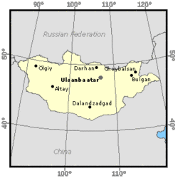 Map of Mongolia. (Source: FAO)
 The country consists principally of inter-mountain plateaux. About 80 percent of the territory lies above 1,000 meters (m). The main mountain ranges are the Mongolian Altai in the west and the Hangai and Hentii mountains in the north and center, with the large depression of the Great Lakes located between the two ranges. A large part of south Mongolia is covered by the Gobi Desert steppe, while the eastern part consists of elevated plains.
The total cultivable area is estimated at 1.8 million hectares (ha), which is about 1 percent of the total area. Some 80 percent of the total land area can be used for pastoral activities. The main crop growing areas are in the central-northern part of the country and include portions of Selenge, Tuv, and Bulgan aimags, which account for about 67 percent of all cultivated land. These areas comprise a broad basin draining to the north. Only valley bottom land and the lower slopes of hills with sufficiently deep soils are cultivated. In 1992, the total cultivated area was 664,700 ha. Cereals, occupying nearly 600,000 ha or over 90 percent of the total cropped area in 1992, are the most important crops, but have declined recently due to the reduced availability and increased cost of production inputs and shortage of working capital. About 53,000 ha, or 8 percent of the total arable area, were devoted to fodder crops in 1992. Potatoes and vegetables together accounted for 11,000 ha, or 1.5 percent of the area planted, while fruit trees covered an area of about 700 ha.
In 1996, the population of Mongolia was estimated at 2.5 million inhabitants (600,000 in Ulaanbaatar). The annual population growth rate in the 1980s was 2.7 percent. Mongolia is sparsely populated with an average density of 1.6 inhabitants/km2, and about 38 percent of the population is rural. In 1995, the agriculture sector (including livestock) accounted for over 25 percent of Gross Domestic Product (GDP), and employed 28 percent of the economically active population.
Climate and Water Resources
Climate
The country has severe climatic conditions with long cold winters. The average annual precipitation is 251 millimeters (mm), ranging from 400 mm in the north to less than 100 mm in the southern Gobi region. The mean monthly temperature is below 0°C over the entire country between November and March. Late spring and early autumn (even late summer) frosts reduce the vegetation period to 80-100 days in the north and 120-140 days in the south. Summer precipitation occurs between June and August, representing 80-90 percent of the total annual rainfall. Other climatic factors affecting agricultural production include low soil moisture and air humidity in spring and early summer, and strong winds in spring, resulting in high evaporation and soil erosion.
River Basins and Water Resources
Mongolia's water resources include 32.70 cubic kilometers (km3) of surface water and 6.10 km3 of groundwater. Part of the groundwater flow (estimated at 4 km3/year) returns to the river system as base flow, the rest evaporating in endoreic basins. The river network is more developed in the north than in the south. Several of Asia's major rivers rise in Mongolia including the Yenisei, Irtysh, and Selenge rivers. Rainfall is the principal source of water for the rivers of the region, while water from melting snow makes up 15-20 percent of the annual runoff. From November to May, the rivers in the north are frozen. Further south, the shallow water courses of the Gobi are fed almost exclusively by groundwater.
Mongolia can be divided into five major river basins:
- the Amur basin in the east, comprising the Kerulen River, which flows into Lake Hu-Lun in China, and the Onan River, a tributary of the Amur River; the outflow to China from this group of [[river]s] is estimated at 1.4 km3/year;
- the Lake Baikal basin in the north-central part of the country, with the Orhon and Selenge rivers rising in the north and central mountains;
- the Shishhid basin in the northwest is an extension of the Yenisei basin; the total outflow of the Mongolian rivers to the Russian Federation is estimated at 25 km3/year;
- the Bulgan basin is an extension of the Irtysh basin in the southwest of the country;
- the Gobi Desert basin covers the south and west of the country and consists of small rivers which drain internally into lakes or are lost in the ground.
About two-thirds of the surface runoff leaves Mongolia. Mongolia has a formal understanding with the Russian Federation on water quantity and quality.
Lakes and Dams
The largest lakes are in the northwest. Among these are the Uvs Nur, a large saline lake without an outlet with an area of 3,350 km2; and the Huvsgul, the largest (2,620 km2) and the deepest (238 m) freshwater lake in Mongolia, which is fed by 46 [[river]s] and other large lakes.
About 27 earth dams currently store water for sprinkler irrigation systems. A small part (55 km2) of the catchment drained by the Boroo River is intercepted by the Shariin Am dam and storage reservoir facility. The Shariin River is a narrow and shallow river with a small dam about 4 m high capable of impounding a small storage reservoir with a regulating capacity of about 250,000 m3.
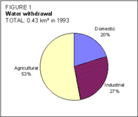 Figure 1. Water withdrawal (Source: FAO)
 Mongolia is estimated to have a theoretical hydropower potential of 5,500-6,000 megawatts (MW). There is a 528 kilowatts (kW) mini-hydroplant in operation (the Kharakhoum scheme) on an irrigation canal which diverts water from the Orkhon River.
Water Withdrawal
The total water withdrawal was estimated at about 0.43 km3/year in 1993, of which 52 percent was for agriculture (Figure 1). Groundwater is currently the main source of supply for household and drinking use, watering points for pastures, and industrial consumption. About 82 percent of the total water supply is contributed by groundwater resources (Figure 2).
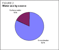 Figure 2. Water use by source (Source: FAO)
 Irrigation and Drainage Development
Irrigation in Mongolia was probably developed under the Huns in the first century AD. Irrigation development appears to have peaked at about 140,000 ha during the seventeenth and eighteenth centuries.
Traditional irrigation methods had been largely abandoned by the end of the nineteenth century. Chinese "migrants" developed comparatively small-scale schemes on the larger [[river]s]. Modern irrigation development started in the 1950s, and the first modern irrigation scheme was designed in 1955.
About 518,000 ha of irrigation potential area were identified at reconnaissance level in the early 1970s, of which 117,000 ha have been studied in more detail for potential development. Starting in 1971, some small irrigation schemes were built in the western aimags. A government campaign began in 1975 to produce irrigated fodder in the western and Gobi regions. The construction of further irrigation schemes, large and small, continued until 1988.
In the 1980s, irrigation schemes were characterized by sprinkler systems, generally serving 400-500 ha or more, primarily for fodder and cereal production and, to a lesser extent, for vegetables and potato production (Figure 3).
 Figure 3. Evolution of irrigation, 1982-1993 (Source: FAO)
 In 1993, the total irrigated area was estimated at 84,300 ha. The total area equipped for irrigation amounted to 57,300 ha, of which 43,400 ha under sprinkler systems (registered schemes) and about 13,900 ha of systems using surface irrigation methods (unregistered schemes) (Figure 4). In addition, an estimated 27,000 ha of pasture benefited from traditional floodwater diversion (Figure 5).
There is an inventory of 156 registered schemes, covering a total of 43,400 ha, varying in size between 5 and 3,300 ha, two-thirds of them being smaller than 50 ha. Most schemes have been developed in the north (48 percent) and west (47 percent). Unregistered schemes, an estimated 80 percent of them concentrated in the west of the country, are smaller in size (1-100 ha) and are the result of spontaneous efforts by local people, or are state schemes taken over by companies and private individuals after being abandoned.
Of the sprinkler irrigated area, side-roll systems account for 43 percent; tractor mounted water guns or sprinkler booms, 28 percent; center pivots, 25 percent; and movable laterals, 4 percent. About 46 percent of the total irrigated area is served by gravity canals and the remaining 54 percent by buried steel pipes.
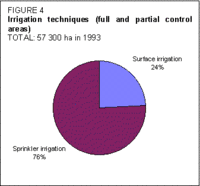 Figure 4. Irrigation techniques (full and partial control areas) (Source: FAO)
 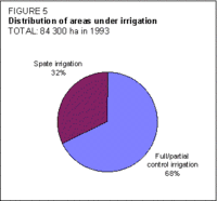 Figure 5. Distribution of areas under irrigation (Source: FAO)
 The total sprinkler irrigated area has been in steady decline with the privatization of the state farms operating the systems and the subsequent lack of finance. In 1992, only 52 percent of the total area under sprinkler systems, or 22,000 ha, was operational. Of the remaining area, 11,000 ha are classified as abandoned for irrigation purposes, while the other 10,000 ha are defined as non-functional due to failed or missing equipment. Individual irrigators have established plots on schemes as the farming companies have withdrawn from irrigation.
According to updated cost estimates provided by the Ministry of Food and Agriculture, registered irrigation investment averaged about US$1,300/ha at 1993 prices, with infrastructure representing 87 percent of this amount. In 1995, an FAO (Food and Agriculture Organization (FAO)) mission estimated new irrigation establishment costs at approximately US$2,000/ha and rehabilitation costs at approximately US$700-1,000/ha.
During the 1980s, fodder crops accounted for approximately 50 percent of the area irrigated under sprinkler systems; annual cereal crops (mainly wheat), 20-40 percent; potatoes, 5-10 percent; vegetables (mainly cabbage, onions, carrots, and turnips), 5-10 percent; and fruit (seabuckthorn, black currant, and Siberian apples), less than 2 percent. Unregistered irrigation schemes have focused primarily on potatoes, vegetables, and fruit production, with significant areas of fodder production in the west and south. Fodder, cereals, and potatoes have suffered from the reduction in irrigation extension. Vegetables, some fruits, and early potatoes are the main crops currently grown on irrigation schemes.
Institutional Environment
The main institutions dealing with agriculture and water resources development are the Ministry of Food and Agriculture (MOFA) and the Ministry for Nature and the Environment (MNE).
The MOFA has overall responsibility for formulating irrigation development policy through the Crop, Machinery and Irrigation Department. A three-member Irrigated Crop Unit is located within the Ulaanbaatar head office of the department, with responsibilities extending into rural water supplies and groundwater, as well as irrigated crop production. However, the ministry does not have a design function in the planning of irrigation schemes.
The MNE is responsible for implementing state policy related to land, weather, water, wildlife, and forests. It determines whether water use by irrigation schemes has impacts on the environment. Institutes relevant to irrigation within the MNE are the Water Policy Institute, the Land Policy Institute, and the Hydrometeorological Research Institute.
The MOFA and MNE are represented at aimag level through the Chief of Agricultural and Environmental Section (CAES). The CAES is assisted by a team of technicians and is answerable to both the aimag government chairman and the MOFA. There are a number of crop and irrigation technicians posted at soum level (soum is an administrative subdivision of the aimags) in charge of assisting large crop production farms.
A water law has been in force since June 1995.
Trends in Water Resources Management
Mongolia's goal is to develop a market-oriented agriculture sector with minimal state intervention. According to the 'Mongolia irrigation rehabilitation project' the objectives are:
- to restore to full productive capacity around 1,550 ha of irrigation schemes in the north-central region;
- to strengthen the capacity of government and private institutions involved in irrigation development;
- to form WUAs and train farmers in the O&M of irrigation systems and irrigated crop production;
- to develop irrigated crop production technologies adapted to the new production systems, especially to smallholders, and to identify and promote new irrigated crops adapted to Mongolian conditions.
In addition, a 12-15 MW hydropower project has been planned for the west of the country, on the Haraigth River in Hovd province. It has been designed by Erdenet University of Mongolia with the Hydroprojekt Institute of the Russian Federation. A 2 MW hydroplant is soon to be completed in the province of Zafkhan.
Further Reading
- FAO. 1994. Irrigation rehabilitation project site-specific studies. Report No. 85/94 ADB-MONGOLIA. Rome.
- FAO. 1996. Irrigation rehabilitation project: preparation project. Volumes 1, 2 and 5. Report No. 96/006 ADB-MONGOLIA. Rome.
- FAO. 1996. Irrigation rehabilitation project: preparation report. Volume 1. Report No. 96/006 ADB-MON. Rome.
- Statistisches Bundesamt. 1992. Landerbericht. Mongolei, p. 84.
- UNDP. 1996. Development cooperation, 1995 report: Mongolia, p. 207.
- United Nations Industrial Development Organization. 1993. Mongolia: restructuring for a market economy, p. 74. Industrial development review series.
- World Bank. 1994. Mongolia country economic memorandum: priorities in macroeconomic management, p. 37. Report No. 13162-MOG.
- World Bank. 1995. Mongolia: prospects for wheat production, p.33. Report No. 13882-MOG.
- Water Profile of Mongolia, Food and Agriculture Organization.
- World Factbook: Mongolia, Central Intelligence Agency.
| Disclaimer: This article is taken wholly from, or contains information that was originally published by, the Food and Agriculture Organization. Topic editors and authors for the Encyclopedia of Earth may have edited its content or added new information. The use of information from the Food and Agriculture Organization should not be construed as support for or endorsement by that organization for any new information added by EoE personnel, or for any editing of the original content. |