Water profile of Maldives
Contents
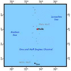
Geography and Population
Maldives consists of 1,190 low-lying islands, lying along a north-south axis over a distance of some 1,000 kilometers (km), about 600 km southwest of Sri Lanka in the Indian Ocean.
The total land area of Maldives is 300 square kilometers (km2). The islands form 26 natural atolls, which for administration purposes are grouped into 19 units. Most of the islands are small, few with a land area in excess of 1 km2, and with elevations of not more than 2 meters (m) above sea level. The atoll lagoons are shallow, but there are deep passages between the atolls. All the main islands lie on the edge of the atolls around their rim. Some sandbars and cays are found within the atolls.
In 1974, the cultivable area was estimated at some 2,800 hectares (ha), 9 percent of the total land area. However, in 1995 the total cultivated area was estimated to be 3,000 ha. Of the cultivated area, 2,000 ha were under permanent crops such as coconut and arecanut. Annual crops such as maize, sorghum, cassava, onion, and chilies were grown on an area of 1,000 ha.
In 1996, the total population was estimated at 263,000 inhabitants with an annual average growth rate of 2.8 percent. The population is concentrated on Male island, which had about 63,000 inhabitants in 1995 . Many of the other islands remain sparsely populated and the average population density is 877 inhabitants/km2.
In 1995, the country's Gross Domestic Product (GDP) was US$270.9 million, of which the agriculture sector contributed approximately 7.7 percent. In 1996, the agriculture sector provided employment for 29 percent of the population.
Climate and Water Resources
Climate
The islands have a tropical climate with two monsoons, which are:
- The southwest monsoon from May to September
- The northeast monsoon from November to March
During the months of April and October, the islands experience many thunderstorms. The precipitation is uniformly distributed throughout the year, except for a dry period of about 90 days from January to March. The mean annual rainfall for the period 1991-1995 was 1,883 millimeters (mm).
The daily temperature varies little throughout the year. The annual mean temperature is 28°C, ranging from 26.2° to 30.6°C.
River Basins and Water Resources
The islands do not have any rivers, but small brackish ponds are found on some islands. Rainwater is collected through water harvesting on a small scale and used for drinking purposes.
Groundwater is found in freshwater lenses underlying the atolls and floating on top of the saline water. Heavy abstraction of this as the main source of drinking water has depleted the freshwater lenses, especially in the capital city of Male, causing salt water intrusion. Groundwater is recharged by rainfall but becomes contaminated while percolating through the soil, which is generally polluted with organic and human wastes. A rough estimate of the groundwater resources, based on an assumed 0.1 m/year recharge throughout the country (300 km2), is 0.03 cubic kilometers per year (km3/year), which would be the only renewable resource of Maldives, though hardly exploitable because of seawater intrusion and pollution.
Maldives finds it extremely difficult to obtain suitable drinkable water. In 1991, there were three desalination plants in operation with a total production of 1,000 m3/d.
According to 1990 statistics, 98 percent of the urban population in the city of Male and 57 percent of the rural population on the atolls had access to safe drinking water.
Water Withdrawal
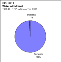
In 1987, water demand for domestic (including municipal) and industrial (including commercial) uses were 3.32 and 0.054 million m3 respectively (Figure 1).
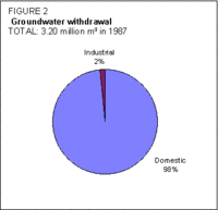
Groundwater sources met the majority of this demand with quantities of 3.15 and 0.053 million m3 (Figure 2). There is no irrigation and crops are rainfed.
Irrigation and Drainage Development
Available information indicates that irrigation activities are insignificant.
Further Reading
- ESCAP. 1995. Guidebook to water resources, use and management in Asia and the Pacific, p. 305. Volume 1: Water Resources and Water Use, Water Resources Series No. 74. ISBN: 9211197058
- Ministry of Planning and Environment. 1991. National development plan 1991-1993: volume 1, p. 168.
- Ministry of Planning, Human Resources and Environment. 1996. Statistical year book of Maldives 1996, p. 342.
- Water Profile of Maldives, Food and Agriculture Organization.
- World Factbook: Maldives, Central Intelligence Agency.
| Disclaimer: This article is taken wholly from, or contains information that was originally published by, the Food and Agriculture Organization. Topic editors and authors for the Encyclopedia of Earth may have edited its content or added new information. The use of information from the Food and Agriculture Organization should not be construed as support for or endorsement by that organization for any new information added by EoE personnel, or for any editing of the original content. |