Water profile of Sierra Leone
Contents
Geography, Climate, and Population
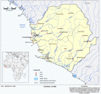 Map of Sierra Leone. (Source: FAO)
 Sierra Leone is located in West Africa between about 10° and 13° W and 7° to 10° N. The country’s total area is 71,740 square kilometers (km2) and it has a north-south extent of about 340 kilometers (km) and a maximum east-west extent of about 300 km. Sierra Leone is bordered by Guinea in the north and east, and by Liberia in the east and south. Its Atlantic Ocean coastline in the south and west is about 400 km long. The country’s highest point is Loma Mansa (Bintimani) reaching 1,948 meters (m). There are four main physical regions:
- Coastal plains (covering 14 percent of the country’s area)
- Interior plains (43 percent)
- Plateau (22 percent)
- Hills and mountains (21 percent)
About 74 percent of the country’s area is considered suitable for crop production on a sustainable basis. In 2002, the cultivated area was estimated at 600,000 hectares (ha), or 8 percent of the country’s area and 11 percent of the cultivable area, of which 535,000 ha was arable land and 65,000 ha under permanent crops.
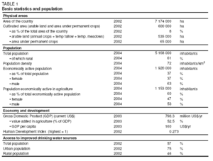 Table 1. Basic statistics and population. (Source: FAO)
 Sierra Leone is situated at the northern limit of the equatorial rainforest zone, with a hot and humid tropical climate. The country is well watered and is one of the most humid countries of Africa with a mean annual rainfall of 2,526 millimeters per year (mm/yr), ranging from 1,900 to more than 4,000 mm/yr. There are two distinct seasons: the pronounced dry season lasts from December to March and receives 6 to 7 percent of the annual total rainfall, coinciding with solar radiation of between 25.9 and 60.9 kilocalories per cubic centimeter (kcal/cm2) and low humidity. Relative humidity is between 95 and 100 percent in the rainy season but it can drop down to 20 percent in the harmattan season. Evaporation is between 1,200 and 1,900 mm/yr. The mean daily temperature varies between 25°C and 28°C.
In 2004, Sierra Leone’s population was almost 5.2 million, of which 61 percent were rural (Table 1). Population density was 72 inhabitants/km2, and the annual population growth rate was 2 percent. By 2003, Sierra Leone’s human development and social indicators were about the worst in the world. They include low Gross Domestic Product (GDP) per capita, lagging primary school enrollments, low life expectancy, and high infant mortality rates, while endemic diseases, especially malaria and HIV/AIDS loom as a menace.
After the decade-long war, poverty in Sierra Leone is severe with about 80 percent of the population living in absolute poverty with expenditure levels below US$1 per day. Poverty is primarily rural, as 62 percent of the country’s population live in rural areas. The incidence of poverty, based on the information for 2003, is 88.3 percent in rural areas, compared to 70.6 percent in small towns and 76.6 percent in large towns. In 2001, the Government formulated an Interim Poverty Reduction Strategy Plan (I-PRSP), and is now embarking on the formulation of the full PRSP. In 2002, 57 percent of the population had access to improved drinking water sources. This coverage was 75 percent in urban areas and 46 percent in rural areas.
Economy, Agriculture, and Food Security
Sierra Leone’s GDP was US$793.3 million in 2003. Agriculture is a vitally important component of the national economy; in 2002, it represented 52.5 percent of GDP and employed 60 percent of the total economically active population, mostly in small-scale, peasant production. The agriculture sector has four subsectors: crops, contributing the largest share to agricultural GDP, livestock, forestry, and fisheries.
The civil conflict has seriously disrupted agricultural activities countrywide. As a consequence, in 2003 only about 47 percent of the natural cereal requirement of 626,704 tonnes were domestically produced. Livestock population and fish production have also been reduced significantly.
Food poverty is widespread. Most households do not have access to an adequate food supply due to both low domestic production levels and abysmally low incomes. In May 2002, Sierra Leone’s President announced his determination to ensure that by 2007 no Sierra Leonean would go to bed hungry.
In 2002, the most important staple food, rice, occupied nearly 402,200 ha. Cassava, the second most important food crop, took 81,540 ha and sweet potato 10,390 ha. During the war period, there was a perceptible change in crop production patterns as tuber crops (cassava and sweet potato) were becoming more widespread because tubers, and in particular cassava, require relatively low husbandry and are less vulnerable to looting. Other food crops grown in the country include maize, sorghum, fundi (cereal), and groundnuts. In the area of tree crops, cocoa, and coffee are grown largely for exports. Others include oil palm and kola nuts.
The predominant type of farming in Sierra Leone is the bush fallow system, with holdings ranging from 0.5 to 2 ha. Up to 10 different crops are traditionally grown in mixed stands in one season, with rainfed upland rice dominating, being grown by 96 percent of farmers. Traditionally, farmers use the inland valley swamps (IVS) for rice in the rainy season, followed in the dry season by groundnut, vegetables, potatoes, and cassava.
Typically, crop production is characterized by low yields and productivity and occurs in a setting severely deprived of institutional facilities. Farm inputs, including tools, seeds, and technology are inadequate and rudimentary. The typical farmer exhibits a very poor knowledge of agronomy and is inhibited by the absence of institutional credit as well as organized markets for farm produce. The bad state of the overall road network, particularly feeder roads, restricts access to major markets. These factors severely constrain the expansion of farm incomes to pay for other necessities, including food. The sector policy framework is inadequate. No official comprehensive and coherent agricultural and food security policies have ever been adopted. However, in 2002 a draft Agricultural Development Policy was prepared.
Water Resources and Use
Water Resources
Sierra Leone can be divided into twelve river basins, of which five are shared with Guinea and two with Liberia. The most important ones, from west to east, are: the Kolente (Great Scarcies), Kaba, Rokel, Pampana (Jong), Sewa, Moa, and Mano. The groundwater resources of the country have not been extensively studied. They correspond almost totally to the baseflow of the rivers and the permeability of the substratum is high.
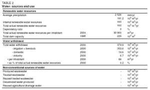 Table 2. Water sources and use. (Source: FAO)
 Internal renewable water resources are estimated at 160 cubic kilometers (km3/year), with surface water accounting for 150 km3/year of them. Seasonal variations are important: only 11-17 percent of the annual discharge occurs between December and April, with minimum discharge in April. Internally produced groundwater is estimated to be 50 km3/year. Of that, 40 km3/year is considered to be overlap between surface water and groundwater.
Wetlands are important in rice and vegetable production. Sierra Leone signed the Ramsar Convention on Wetlands in 1999 and 66 Ramsar sites exist in the country.
Sierra Leone has only one major dam, the 68 meter-high Guma dam, built for hydroelectricity purposes close to Freetown. However, there is considerable potential for the development of small-scale hydroelectric schemes that could also be designed to accommodate irrigated agriculture. An inventory identified 21 sites for hydropower development, with a hydroelectric potential which already exceeds by far the medium-term demand of the country (the total potential is believed to be much higher).
Water Use
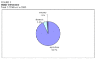 Figure 1. Water withdrawal in Sierra Leone. (Source: FAO)
 Total water withdrawal in the year 2000 was estimated to be 379.9 million cubic meters (m3) (Table 2). Irrigation is the major water user, with a withdrawal of 353.6 million m3 in 2000, followed by the domestic sector with 19.6 million m3 and industry with 6.7 million m3 (Figure 1). About 80 percent of the rural population obtains its water from surface sources, including many streams and ponds. Groundwater is used for a limited number of rural wells and recent installations for large cities. A good number of provincial towns enjoy pipe-borne treated water.
International Water Issues
Sierra Leone shares several river basins with neighboring countries, such as the Kolente (Great Scarcies) and the Kaba with Guinea, the Mano with Liberia, and the Moa with Guinea and Liberia. The inflows into Sierra Leone from these transnational watercourses are considered negligible. Sierra Leone is a member of the Mano River Union, a regional body whose activities impact on agriculture and rural development.
Irrigation and Drainage Development
Evolution of Irrigation Development
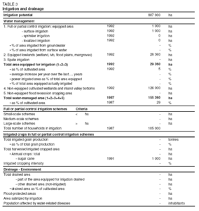 Table 3. Irrigation and drainage. (Source: FAO)
 Sierra Leone’s irrigation potential was estimated at 807,000 ha in 1981 (Table 3). The breakdown of cultivable land into upland]and lowland is given in Table 4. It shows the relative importance of the four classes of lowlands, with a total area of 1.165 million ha: inland valley swamps (IVS), bolilands which are drainage depressions, mangroves in the coastal tidal zone, and annually flooded riverine grasslands. It should be noted, however, that these 1.165 million ha correspond to the total area of lowlands. Lowland suitable for development is about 807,000 ha, corresponding to the above irrigation potential, leaving aside environmental aspects.
Irrigated agriculture is poorly developed in Sierra Leone, and no recent data on its extent are available. Generally, areas with good water control and having the possibility of more than one crop a year are very limited. In 1992, 1,000 ha were reported to be irrigated for sugar cane production and 28,360 ha of wetland had been equipped for rice cultivation, although most of it was not operational. Thus the area equipped for irrigation was 29,360 ha in 1992. In 1992, 126,000 ha of non-equipped wetlands and inland valley bottoms were cultivated, bringing the total water managed area in 1992 to 155,360 ha (Table 3 and Figure 2).
|
Table 4. Breakdown of cultivable and cultivated land (1992) Ecology Cultivable (ha) Cultivated (1992) (ha) Cultivated, as percent of cultivable (%) Upland 4,200,000 500,000 11.9 Lowland 1,165,000 155,000 13.3 -IVS 690,000 100,000 14.5 -Boliland 145,000 10,000 6.9 -Riverine grasslands 130,000 20,000 15.4 -Mangrove 200,000 25,000 12.5 Total 5,365,000 655,000 12.2 Simple drip irrigation systems (bucket & hose type) are currently being introduced to Sierra Leone by an nongovernmental organization (NGO), which distributed about 500 kits in 2003 after test systems met with approval. The NGO plans to ship another about 4,000 kits to the country. (Water profile of Sierra Leone) Role of Irrigation in Agricultural Production, the Economy, and SocietyThe main irrigated crop is rice, and five principal rice ecosystems are generally identified: 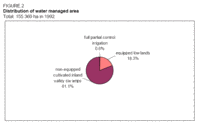 Figure 2. Distribution of water managed area. (Source: FAO) Figure 2. Distribution of water managed area. (Source: FAO)
The reduced fallow period, induced by increasing population pressure, has had adverse impacts on the soil fertility for upland cropping. The IVS have relatively more fertile soils than the upland areas and can support a higher cropping density. Although the government has attempted to develop double cropping of rice by developing the IVS for irrigation, the high cost of development and weak extension capability has so far made this option unsuccessful. Rice yields in traditional wetland are about 1.5 tonnes/ha, while in upland areas they are around 1 tonne/ha. In farmer-managed demonstration plots, yields reach an average of 3.2 tonnes/ha. The other two main crops grown in wetlands, namely cassava and sweet potato, have an average yield of 2.2 tonnes/ha and 2.7 tonnes/ha respectively. Water Management, Policies, and Legislation Related to Water Use in AgricultureInstitutionsSeveral agencies have been, to a limited extent, involved in the assessment of the potential water resources, such as the Guma Valley Water Company, Department of Energy and Power, Water Supply Division, Geological Survey, and Land and Water Development Division (LWDD) of the Department of Agriculture and Forestry. The LWDD is responsible for appraisal of the land and the water resources of the country and to help develop sustainable agriculture. It has several technical sections: agronomy, remote sensing, soils, agroclimatology, analytical laboratory, water resources, and cartography. The Water Resources Section is in charge of investigating the water resources of the country with regard to their utilization for agricultural and rural development. This includes design preparation for swamp development. It liaises with the Water Supply Division of the Ministry of Energy and Power to investigate groundwater resources potential and for the siting and drilling of wells. The Guma Valley Water Company is responsible for supplying water throughout Freetown and its environs; it supplies treated water from its main source at Guma Dam. Water ManagementAs water resources have never been a serious constraint to development in Sierra Leone, no base exists for their management (except for the water supply and sanitation sector). Policies and LegislationThere is no comprehensive water resources development policy or strategy (except for the water supply and sanitation sector with the Sierra Leone Water Company Act of 1991) in Sierra Leone, for the same reason already mentioned above: water resources have never been a serious constraint to development in the country. Environment and HealthIn the context of the World Wetlands Day Celebrations (2003) in Sierra Leone the following threats to wetlands in the country were identified:
The traditional slash-and-burn agriculture has resulted in deforestation and soil exhaustion. Perspectives for Agricultural Water ManagementIn 1990, the country’s target was to reach self-sufficiency in rice production and the major focus for increasing rice production is the further development of the inland valley swamps. Such developments have largely failed to date for lack of appropriate water control technologies adapted to the farmers’ needs, and the proper economic incentives. The development of wetlands to allow for double cropping has so far proved to be unsuitable and costly. Future efforts will probably concentrate on increasing yields in swamp rice cultivation, by concentrating on the most productive land and intensifying the use of available production technology. The returns from mechanization have proved to be higher in the riverine grasslands than in the other rice cultivation ecologies. Bolis, given their poor soil conditions, are not expected to play a major role in the future in rice production. Uncertainty and transition characterize the current situation and there is no clear agriculture and food security policy and strategy at the central government level. The anticipated support from the African Development Bank and the FAO (Food and Agriculture Organization (FAO)) should assist in strengthening the capacity of the Ministry of Agriculture, Forestry and Food Security (MAFFS) to develop its functions and to formulate appropriate policies for, amongst all the other sectors, water resources management and irrigation. The African Development Bank has shown interest in financing the Rhombhe and Rolakoh Irrigation Studies program (US$2 million) and study activities are expected to begin soon. The future of irrigation and agriculture in general is primarily related to a return to political stability. Further Reading
| ||||