Water profile of Nigeria

From The Encyclopedia of Earth
(Redirected from Water in Nigeria)
Jump to: navigation, search


October 6, 2008, 4:12 pm
Source: FAO
Topics:

Geography, Climate, and Population

Nigeria is located in the tropical zone of West Africa between latitudes 4°N and 14°N and longitudes 2°2?E and 14°30?E and has a total area of 923,770 square kilometers (km2). The country’s north-south extent is about 1,050 km and its maximum east-west extent is about 1,150 km. Nigeria is bordered to the west by Benin, to the northwest and north by Niger, to the northeast by Chad and to the east by Cameroon, while the Atlantic Ocean forms the southern limits of Nigerian territory. Land cover ranges from thick mangrove forests and dense rain forests in the south to a near-desert condition in the northeastern corner of the country.

Three broad ecological zones are commonly distinguished in the country: i) The northern Sudan Savanna; ii) The Guinea Savanna zone or Middle Belt; and iii) The southern rainforest zone. Based on rainfall and temperature the county is divided into eight agro-ecological zones. In Table 1 these zones are presented in a north-south succession, except the mountainous zone which is found at the border with Cameroon and the plateau zone in the center of the country.

200px-Mapofnigeria.gif 
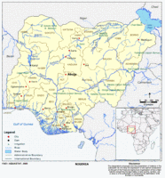
Map of Nigeria. (Source: FAO)

The climate is semi-arid in the north and humid in the south. Except for an ultra-humid strip along the coast with rainfall averages of over 2,000 millimeters pear year (mm/year), where it rains almost all year round, rainfall patterns are marked by distinct wet and dry seasons. Rainfall is concentrated in the period June-September. Deficiency in total annual precipitation is a problem in parts of the country, particularly in the northern parts. In most other areas, however, the major problems are the distribution in time and space and the low dependability of rainfall. Mean annual rainfall over the whole country is estimated at 1,150 mm. It is about 1,000 mm in the center of the country and 500 mm in the northeast. Mean annual pan evaporation is 2,450 mm in the southeast, 2,620 mm in the center and 5,220 mm in the north of the country.

Total cultivable area is estimated at 61 million hectares (ha), which is 66 percent of the total area of the country. In 2002, the cultivated area was 33 million ha, of which arable land covered 30.2 million ha and permanent crops 2.8 million ha (Table 2). About two-thirds of the cropped area is in the north, with the rest about equally distributed between the Middle Belt and the south.

Table 1. Agro-ecological zones in Nigeria Zone description Percentage of country area Annual rainfall Monthly temperature Maximum Normal Minimum (%) (mm) (°C) (°C) (°C) Semi-arid 4 400-600 13 32-33 40 Dry sub-humid 27 600-1,000 12 21-31 49 Sub-humid 26 1,000-1,300 14 23-30 37 Humid 21 1,100-1,400 18 26-30 37 Very humid 14 1,120-2,000 21 24-28 37 Ultra humid (flood) 2 › 2,000 23 25-28 33 Mountainous 4 1,400-2,000 5 14-29 32 Plateau 2 1,400-1,500 14 20-24 36 Table 2. Basic statistics and population. (Source: FAO (Water profile of Nigeria) )

Nigeria is by far the most populous country in Africa, with its 127 million people accounting for about one-seventh of the total population of Africa’s 53 countries (2004). Population density is 138 inhabitants/km2, annual growth rate is 2.2 percent and 52 percent of the population is rural. In 2002, 60 percent of the total population was using improved drinking water sources, with 72 percent in urban areas and 49 percent in rural areas (Table 2).

Poverty worsened during the 1980s and 1990s, with more than 35 percent of the population living below the US$1/day poverty level in 2001. Real income and consumption per capita are as low as at independence 40 years ago. Poverty is particularly widespread in rural areas, where 40 percent of the population lives below the poverty line. More than 5 percent of the rural population is affected by HIV/AIDS and more than 50 million Nigerians suffer from a combination of diseases of protein-energy malnutrition. The social and economic consequences of this pandemic and malnutrition are felt widely, not only in the health subsector, but also in education, agriculture, services, and human resources.

Economy, Agriculture, and Food Security

Nigeria’s economy is highly dependent on oil revenues, which account for about 90 percent of total exports and for about 70 percent of government revenues. The country’s Gross Domestic Product (GDP) in 2003 was estimated at US$50.2 billion, and in 2002 the contribution from agriculture was 37.4 percent, with about 90 percent of the agricultural output coming from the smallholder sector. Agriculture provides occupation for 30 percent of the economically active population. Thirty eight percent of agricultural workers are female.

Nigeria is listed by FAO (Food and Agriculture Organization (FAO)) among those nations that are at the moment technically unable to meet their food needs from rainfed production at a low level of inputs and appear likely to remain so even at intermediate levels of inputs at some points in time between 2000 and 2025. Farming systems are mainly smallholder-based and agricultural landholdings are scattered. Simple, low-input technology is employed, resulting in low-output labor productivity. Typical farm sizes range from 0.5 ha in the densely populated high-rainfall south to 4 ha in the dry north.

Nigeria’s wide range of agro-ecological zones allows for a diversity of crop production activities:

  • The dry northern savanna is suitable for sorghum, millet, maize, groundnuts, and cotton; sorghum and millet are the most important crops
  • In the Middle Belt and south the main food crops are cassava, yam, plantain, maize, and sorghum
  • In the south, the main cash crops are oil palm, cocoa, and rubber
  • Low-lying and seasonally flooded areas are increasingly producing rice

Water Resources and Use

Water Resources

The country is well drained with a close network of rivers and streams. Some of these, particularly the smaller ones in the north, are seasonal. There are four principal surface water basins in Nigeria:

  • The Niger Basin has an area of 584,193 km2 within the country, which is 63 percent of the total area of the country, and covers a large area in central and northwestern Nigeria. The most important rivers in the basin are the Niger and its tributaries Benue, Sokoto, and Kaduna.
  • The Lake Chad Basin in the northeast with an area of 179,282 km2, or 20 percent of the total area of the country, is the only internal drainage basin in Nigeria. Important rivers are the Komadougou Yobe and its tributaries Hadejia, Jama’are, and Komadougou Gena.
  • The southwestern littoral basins have an area of 101,802 km2, which is 11 percent of the total area of the country. The rivers originate in the hilly areas to the south and west of the Niger River.
  • The southeastern littoral basins, with the major watercourses being the Cross and Imo Rivers, have an area of 58,493 km2, which is six percent of the total area of the country, and receive much of their runoff from the plateau and mountain areas along the Cameroon border.

Nigeria has extensive groundwater resources, located in eight recognized hydrogeological areas together with local groundwater in shallow alluvial (fadama) aquifers adjacent to major rivers:

  • The Sokoto Basin Zone comprises sedimentary rocks in northwest Nigeria. Yields range from below 1.0 to 5.0 liter per second (L/s).
  • The Chad Basin Zone comprises sedimentary rocks. There are three distinct aquifer zones: Upper, Middle, Lower. Borehole yields are about 1.2 to 1.6 L/s from the Upper unconfined aquifer and 1.5 to 2.1 L/s from the Middle aquifer.
  • The Middle Niger Basin Zone comprises sandstone aquifers yielding between 0.7 and 5.0 L/s and the Alluvium in the Niger Valley yielding between 7.5 and 37.0 L/s.
  • The Benue Basin Zone is the least exploited basin in Nigeria extending from the Cameroon border to the Niger-Benue confluence. The sandstone aquifers in the area yield between 1.0 and 8.0 L/s.
  • The Southwestern Zone comprises sedimentary rocks bounded in the south by the coastal Alluvium and in the north by the Basement Complex.
  • The South-Central Zone is made up of Cretaceous and Tertiary sediments centred on the Niger Delta. Yields are from 3.0 to 7.0 L/s.
  • The Southeastern Zone comprises Cretaceous sediments in the Anambra and Cross River basins. Borehole numbers are low due to abundant surface water resources.
  • The Basement Complex comprises over 60 percent of the country’s area. It consists of low permeability rocks and groundwater occurs in the weathered mantle and fracture zones with yields of between 1.0 and 2.0 L/s.

Lake Chad is an important wetland lying in the semi-arid Sahel corridor. With a mean depth of 3.9 meters (m), its surface area is highly variable, ranging from a minimum of 2,000 km2 in 1907 to a maximum of 22,000 km2 in 1961.

200px-Nigeriawatertable3.gif 
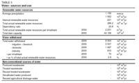
Table 3. Water: sources and use (Source: FAO)

Low-lying areas flooded during the wet season, known as fadama areas, are scattered across the ecological zones of Guinea Savanna, Sudan Savanna, and the Sahel. These diverse wetlands are valuable for grazing, agriculture, and other domestic uses, and are deemed of international importance as breeding grounds for migratory birds, thereby having a global value for biodiversity.

Nigeria’s total annual renewable water resources are estimated at 286.2 km3 (Table 3). Annual internally produced resources amount to 221 cubic kilometers (km3), made up of 214 km3 surface water and 87 km3 groundwater, while 80 km3 of the latter is assumed to be overlap between surface water and groundwater. External water resources are estimated at 65.2 km3/year, being surface water coming from Niger, Cameroon, and Benin. Exploitable surface water resources are estimated to be 80 percent of the natural flow, which is about 96 km3/year. Annual extractable groundwater resources are about 59.51 km3, distributed as follows: 10.27 km3 in northern Nigeria; 25.48 km3 in the Middle Belt; 23.76 km3 in the south. Dam capacity is estimated to be 44.2 km3.

Water Use

200px-Nigeriawaterfigure1.gif 
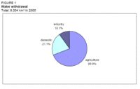
Figure 1. Water withdrawal. (Source: FAO)

Total annual water withdrawal was estimated at 8 km3 for the year 2000. Agriculture was the biggest water user with 5.5 km3, or 69 percent of the total water withdrawal, followed by the domestic sector with about 1.7 km3 (21 percent) and industry with 0.8 km3 (10 percent) (Table 3 and Figure 1).

International Water Issues

Nigeria is a member of two regional authorities dealing with the management of shared water resources:

  • The Niger Basin Authority (NBA) was formed in 1964 and is made up of the nine countries that share the Niger Basin (Guinea, Côte d’Ivoire, Mali, Burkina Faso, Algeria, Benin, Niger, Chad, Cameroon). The principal aim of the authority is to ensure the integrated development of the basin.
  • The Lake Chad Basin Commission (LCBC) comprises representatives of Cameroon, Central African Republic, Chad, Niger, and Nigeria. Its objective is to ensure a rational and equitable development of natural resources, including water, of the Lake Chad Region.

In addition, Niger and Nigeria by signing the Maiduguri Agreement in 1990 have established a joint commission to monitor and assess development options, in particular water resources development, in the four major sub-basins common to the two countries. However, the implementation of the Agreement has been ineffective so far.

Irrigation and Drainage Development

Evolution of Irrigation Development

Irrigation potential estimates in Nigeria vary from 1.5 to 3.2 million ha. The latest estimate gives a total of about 2.1 million ha, of which about 1.6 million are from surface water and 0.5 million ha from groundwater. However, as far as groundwater is concerned, it should be mentioned that while the extractable water resources are sufficient for up to 0.5 million ha in the north of Nigeria, areas suitable for irrigation with groundwater have, as yet, not been assessed. Areas with irrigation potential using surface water are given in Table 4.

Table 4. Irrigation potential using surface water Zone Uplands River valleys Inland swamps Delta swamps Total (ha) (ha) (ha) (ha) (ha) % North 343,000 578,500 154,100 - 1,075,600 68 Middle Belt 82,000 28,000 28,000 - 138,000 9 South 180,000 11,000 93,400 78,000 362,400 23 Total (ha) 605,000 617,500 275,500 78.0 1,576,000 100 % 38 39 18 5 100 Figure 2. Structure of the irrigation sub-sector in Nigeria in 2004. (Source: FAO (Water profile of Nigeria) )
</div>

During the oil boom of the 1970s, an investment program in support of public irrigation was launched. Public irrigation in the Nigerian context means schemes run either by River Basin Development Authorities (RBDAs) or by the States (Figure 2). The program included the construction of large dams and pumping stations, especially in the drier northern part of the country. By 1990, 162 dams had been constructed with a total storage capacity sufficient to irrigate 725,000 ha if developed. Many of these dams, however, were built with little or no infrastructure and the sites chosen do not always have sufficient irrigable areas close by. The schemes that were developed have not been brought into production fully or they have been implemented with inappropriate infrastructure. By 2004, only about 20 percent of the area planned for public sector irrigation had been developed and only 32 percent of the developed area was being irrigated.

The poor utilization of the developed irrigation area in the public irrigation sector can be attributed to a number of factors including: i) the lack of a coherent irrigation subsector development policy and strategy; ii) insufficient attention to management systems; iii) inadequate funding (including poor cost recovery); iv) high capital and operating costs; v) inadequate farm support services; vi) poor operation, repair and maintenance; vii) a low level of project ownership acceptance by the direct beneficiaries; and viii) uncertain financial and economic viability. Because of these lapses, a number of schemes have already deteriorated badly and are in urgent need of major renovation and repair, less than 20 years after their construction.

200px-Nigeriawatertable5.gif 
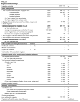
Table 5. Irrigation and drainage. (Source: FAO)

Traditionally many farm families in Nigeria had cultivated small areas in fadamas during the dry season, using water manually drawn from shallow wells or streams. Major fadama areas are located along the flood plains of the Niger, Sokoto Rima, Benue, and Yobe rivers. The promotion of pumps and tubewells, which allow for the extraction of greatly increased amounts of water, began in the late 1980s through Agricultural Development Projects (ADPs). By 1992, more than 80,000 pumps each irrigating between 0.5 and 1.0 ha had been distributed. From 1993 onwards, the National Fadama Development Project (NFDP) funded by the World Bank built on the ADPs’ achievements and by the end of the project in 1999, over 55,000 pump sets had been distributed with an equipped area of about 1 ha per pump.

Private sector irrigation in Nigeria is small-scale with the exception of two sugar estates, which operate as private companies but receive government support (but they are almost non-existent at present; for example, of the 7,000 ha equipped for irrigation in Savanna sugar estate only 500 ha were cropped and irrigated in 2004). About two-thirds of the irrigated area of the private sector are small-scale areas of commercial vegetable, horticulture, and flower producing schemes around larger cities. The remaining is classified as fadama irrigation, which resulted from the NFDP.

The Special Program for Food Security (SPFS) of the FAO (Food and Agriculture Organization (FAO)) commenced in 1999 with a pilot phase including 280 ha in three villages in Kano State, where farmers were provided with motorized pumps and tubewells to enable them to engage in irrigated agriculture in the fadama lands. The project adopts a participatory community development approach, where farmers’ groups themselves are primarily responsible for planning and have ownership of the project. After the success of the pilot phase, the project was extended in 2002 to 109 sites in all 36 States.

Table 6. Structure of the irrigation sub-sector in Nigeria in 2004 Scheme type Equipped area (ha) Actually irrigated area (ha) Actually irrigated as percent of equipped area (%) River Basin Development Authority 92,317 29,140 32 State schemes 12,200 6,700 (estimated) 55 Private sector- sugar schemes (not including Savannah Sugar Scheme) 5,600 0 0 Private small-scale schemes (as estimated by FMWR) 128,000 128,000 100 Improved fadama (equipped lowland) 55,000 55,000 100 Total 293,117 218,840 75 The area equipped for irrigation in 2004 was 293,117 ha, comprising 238,117 ha of full or partial control irrigation and 55,000 ha of equipped lowlands, i.e. improved fadamas. About 75 percent, or 218,840 ha, of the equipped area were actually irrigated in 2004 (Table 5, Table 6 and Table 7). Non-equipped flood recession cropping is being practiced on 681,914 ha, bringing the total water-managed area to 975,031 ha. Surface irrigation in its various forms (basins, borders, and furrows) is used predominantly for water application in both public and private irrigation schemes. Sprinkler irrigation was practiced on only 3,570 ha in 1991 and was reduced to about 50 ha by the end of 2004. Table 7. Equipped and actually irrigated areas in the River Basin Development Authorities for the year 2004River Basin Development Authority Equipped area (ha) Actually irrigated area (ha) Actually irrigated as percent of equipped area (%) Anamra-Imo 3,941 10 0.3 Benin-Owena 317 0 0 Chad Basin 26,180 1,000 3.8 Cross River 364 40 11.0 Hadejia Jama'are (including areas outside of equipped area using water from main canal) 18,475 21,000 113.7 Lower Benue 1,310 70 5.3 Niger Delta 187 0 0 Lower Niger 1,344 115 8.6 Upper Niger 3,697 722 19.5 Ogun-Osun 512 110 21.5 Sokoto Rima 27,580 5,290 19.2 Upper Benue 8,410 783 9.3 Total 92,317 29,140 31.6 The existing water lifting options or small scale basin irrigation in thenorthern States of Nigeria (Water profile of Nigeria) were found to be:

  • Manual lifting from an open well using a calabash or similar container to irrigate 0.01-0.05 ha. Resource poor farmers with very small land holdings and limited water supplies use this option.
  • Manual lifting with a mechanical advantage using a Shadouf or treadle pump to irrigate 0.05-0.1 ha. The use of Shadoufs is declining with the introduction of small-motorized pumps. Treadle pumps are little known and in general not liked by both men and women. Costs for a pump and well are estimated at US$5-20 for the Shadouf and US$70 for the treadle pump.
  • Fully mechanized lifting using 3.5-5.5 horsepower (HP) petrol motors driving small centrifugal pumps. Irrigated areas are 0.5-1.5 ha, and costs are between US$500-700 for a motor, pump, and well, depending on the water source. Extraction from a river is the cheapest and from a tubule the most expensive option. Before the 1980s, water sources were mostly rivers or open wells in fadamas. Today, washbores and tubewells are most common in fadamas.
  • Single-cylinder water-cooled diesel motor driving a pump and extracting from a tubewell in a fadama or in alluvial plains. Irrigated areas are 0.5-2.0 ha, and costs for a motor, pump, and well are about US$950. This technology is not widely found and usually installed by well-off farmers for multipurpose use. A problem is that diesel is difficult to buy in rural areas, while petrol is always available.

An analysis of developed and actually irrigated areas in RBDA schemes reveals a large difference in performance between gravity-fed and pumped schemes. While 59 percent of the area originally developed for gravity irrigation was irrigated in 2000, this portion dropped to 6 percent for schemes originally developed for using pumps and sprinklers.

Role of Irrigation in Agricultural Production, the Economy, and Society

200px-Nigeriawaterfigure3.gif 
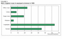
Figure 3. Main irrigated crops in equipped schemes in 1999. (Source: FAO)

With irrigated land being less than one percent of the cultivated area, the contribution of irrigated agriculture to total crop production is small. The impact of irrigation is felt only with regard to specific crops such as wheat, sugar cane, and to some extent rice and vegetables. In the 2003-2004 season irrigated grain production contributed to 0.9 percent of the total grain production and irrigated vegetable production contributed to 2.3 percent of the total vegetable production. The main irrigated crops in 1999 were vegetables, wheat, maize, and sugar cane (Table 5 and Figure 3). Other irrigated crops were rice, potatoes, cotton, cowpeas, oil palm, citrus fruits, cocoa, rubber, taro, and cashew nuts. Typical irrigated crop yields in Nigeria are given in Table 8. The crop with the highest increase in net return resulting from irrigation is sugar cane, due to a four-fold per hectare yield increase. Next are onions and tomatoes, the least profitable crops being rice and wheat. Cropping patterns and crop yields in the Kano River Development Project Phase I for the years 1997 and 1998 are given in Table 9.

Table 8. Selected crop yields in Nigeria in 1998/99 Crop Yield Rainfed Irrigated (t/ha) (t/ha) Wheat (northern Nigeria, dry season) - 2.8 Rice (weighted avg. yield) 2.2 3.5 Sugarcane 6.5 26.0 Tomatoes 6.4 10.0 Onion 6.1 6.6 Pepper 3.2 5.3 Operation and maintenance (O&M) costs are estimated at US$61/ha for gravity-fed schemes and US$530/ha for schemes using pumps. Current policy is for RBDAs to charge on average US$10/ha per season for irrigation water supply (with some variations between schemes), but the fees have proven difficult to recover. Costs recovered vary from scheme to scheme but in any case cover only a fraction of the O&M costs. Nigeria (Water profile of Nigeria) has no culture of maintenance, certainly in the public sector, and it has been shown that small-scale individual farming schemes are successful and maintained when they are farmer-owned and individually operated. Of the larger schemes, few are operable and all are beset with O&M problems including the supply of and access to spare parts.

The capital cost of public sector irrigation schemes in Nigeria is high by any standard. Costs in some projects have been:

  • The Kano River Development Project: US$6,700/ha in 1978 (US$13,500/ha in year 2000 terms) with storage and gravity supply for 15,000 ha of surface irrigation.
  • The Bakolori Project: US$13,500/ha in 1978 (US$27,000/ha in year 2000 terms) for storage and gravity distribution for 15,000 ha of surface irrigation.
  • The Lower Anambra Irrigation Project: US$8,500/ha when completed in 1987 (US$11,200/ha in year 2000 terms) for a river lift (pump) scheme of 3,850 ha with a gravity distribution system.

In contrast, farmer-owned and operated irrigation has low investment costs of about US$530 for a 3 HP pump able to irrigate about 1 ha, and annual operating costs of about US$280/ha. Returns are high as was demonstrated by NFDP. The predominance and availability of the small close-coupled centrifugal pump/motor units, in loan packages that do not reflect the full capital costs, has worked against the introduction of lower cost options such as the treadle pump. In addition, there was a negative experience with the treadle pump in some States due to bad publicity and poor performance of the first pumps. The truly resource-poor farmers still do not have easy access to lifting equipment.

Table 9. Cropping patterns and crop yields in the Kano River Development Project Phase ICrop Wet season Dry season Crop area Yield Crop area Yield 1997 1998 1997 1998 1997 1998 1997 1998 (%) (%) (t/ha) (t/ha) (%) (%) (t/ha) (t/ha) Rice 59 45 3.5 3.5 - - - - Maize 21 27 2.2 2.2 35 51 2.5 2.5 Vegetables (tomatoes, onions, chillies, peppers and okra) 12 19 5.0 5.0 32 25 6.0 6.0 Sorghum 8 9 3.0 3.0 - - - - Wheat - - - - 25 18 2.5 2.5 Other - - - - 8 6 - - Total 100 100 - - 100 100 - - Dry-season farming on fadama lands has two advantages for farmers: Fadama cultivation in the dry and wet season in addition to wet season upland farming allows crop diversification so that if one crop fails other crops will ensure food security.The income realized from dry-season cash crops improves household economics allowing investments for improving productivity and provides money to buy food in the event of crop failure.Although the culture in some of the northern States prevents married women from direct participation in farming, it is the main productive activity and one of the most important occupations of women. Most women describe themselves as farmers first before they talk about other off farm activities. Where cultural practices are enforced strictly, so that married women cannot engage directly in fadama farming, they cultivate land they may inherit or purchase by using the labor of their husbands, friends, other male relatives or hired workers. This presents a cost disadvantage to such women as all fadama cultivation involves relatively high labor inputs. Women who do not farm on their own land work on their husband’s farms and women from poorer households work on farms as farm laborers. In some communities there is a belief that fadama farming is too complicated for women and women are excluded from the more productive aspects of farming. (Water profile of Nigeria)

Status and Evolution of Drainage Systems

It is estimated that 4,000 ha are drained in Nigeria.

Water Management, Policies, and Legislation Related to Water Use in Agriculture

Institutions

The Federal Ministry of Water Resources (FMWR) is the main national coordinating body in the water sector. Its principal functions are to:

  • Formulate and implement national irrigation policy
  • Develop and support irrigated agriculture
  • Coordinate the development and utilization of water resources for irrigation and other purposes
  • Update and implement the Water Resources Master Plan
  • Collect, store, analyze and disseminate hydro-meteorological, hydrological, and other data
  • Support, monitor, and evaluate programs and performances of the RBDAs and the National Water Resources Institute (NWRI)
  • Formulate appropriate water resources legislation
  • Undertake studies and investigations to allow the efficient use of Nigeria’s water resources

Four of FMWR’s eight departments are directly concerned with irrigation subsector matters:

  • The Department of Irrigation and Drainage (DID): among its major responsibilities are the supervision and monitoring of the River Basin Development Authorities (RBDAs)
  • The Department of Planning, Research and Statistics
  • The Department of Hydrology and Hydrogeology
  • The Department of Dams and Reservoir Operations

Other federal institutions involved in the irrigation subsector are:

  • The National Council of Water Resources (NCWR) is the most important water resources policy formulating body.
  • The National Technical Committee on Water Resources (NTCWR) is a sub-committee of the NCWR. The NTCWR has five specialist sub-committees that are important for information exchanges between federal and state level agencies: dams, water supply, irrigation, and drainage, hydrology, and hydrogeology, manpower.
  • The Federal Ministry of Agriculture and Rural Development (FMARD) was involved in irrigation development in the past as it funded, with World Bank support, a series of state-run Agricultural Development Projects (ADPs), including the promotion of irrigation owned and managed by the farmer, particularly in fadama areas, and the provision of extension services to the public sector irrigation schemes of the RBDAs and the State Irrigation Departments.
  • The River Basin Development Authorities (RBDAs) are the main bodies in charge of administering and developing Nigeria’s water resources and are responsible for public sector irrigation at the federal level. They were established in the mid-1970s and the areas of operation are determined by the extent of the river basins they serve. The RBDAs were favorably financed until the end of the oil boom, when their scope and autonomy were limited.

State agencies involved in the irrigation subsector are:

  • The State Ministries of Agriculture (SMAs). They were responsible for irrigation development before RBDAs were established. Irrigation responsibility within the Ministries is with the State Irrigation Departments (SIDs). In most States they are small and suffer from funding constraints and lack of staff capacity and capability to design, implement, and monitor irrigation schemes. Their programs consist more of plans than actual irrigation development, which amounts to 12,200 ha (2004), of which about 6,700 ha are actually irrigated. The informal division within a State is that schemes larger than 2,000 ha are handled by the RBDA concerned.
  • State Ministries of Water Resources exist in some States, and where they exist the SID has been transferred to them.
  • The Agricultural Development Projects (ADPs). They became involved in irrigation in the early 1980s, mainly in small-scale fadama development. In most States, they are responsible for extension services.
  • Local Government Authorities are involved in irrigation in some limited instances by making small pumps available to farmers for fadama-type irrigation.

Water Management

Semi-autonomous project management units manage federally owned and funded irrigation schemes. Those units usually consist of 3-4 departments such as Irrigation, Agriculture, Accounts, Stores, and Workshops, etc. A Project Manager who reports directly to the Managing Director of the RBDA concerned heads the units.

Government policy is to subdivide schemes along the lines of one Water User Association (WUA) per distribution canal; thus, a WUA comprises 10-25 farmers. Responsibilities include O&M of the canal and its structure and adherence to water scheduling programs. A scheme management committee (SMC), for which each WUA elects a representative, then acts as the interface between the WUAs and RBDA or other authorities. Currently WUAs are being established in two RBDA schemes and their activities include the desilting of distribution and tertiary canals and the collection of water charges.

The National Fadama Development Project (NFDP) resulted in the formation of more than 9,000 Fadama User Associations (FUAs). Most were formed with assistance from ADP staff and require further assistance and capacity building to face the challenges of operating and maintaining their schemes.

Finances

Under public sector irrigation (RBDA and SID schemes) the full costs of the schemes as well as a high portion of O&M cost are met by the Federal Government in the case of RBDA schemes and by State Governments in the case of SID projects. However, even in the case of SID schemes the Federal Government meets the cost indirectly as the States depend heavily on federal transfer.

One of the constraints to production under irrigation is the lack of agricultural credit.

Policies and Legislation

Water legislation in Nigeria is use-oriented dealing with navigability, shipping, and domestic use; navigability and confusion over the legal ownership of water as a resource can impede irrigation development. Decentralization is the defining feature of water administration in Nigeria, leading to different ministries and agencies at different levels administering laws without adequate coordination.

The functions of the RBDAs related to irrigation are defined in the River Basin Development Authorities Act No. 35 of 1986.

The Environmental Impact Assessment Decree No. 86 of 1992 lists drainage and irrigation as a Mandatory Study Activity, thus prescribing that environmental impact assessments are to be carried out for irrigation projects.

The Water Resources Decree No. 101 of 1993 gives the FMWR significant power to control and coordinate activities for proper watershed management and resources protection and for public administration of water resources. It confers to the FMWR the responsibility to make proper provision for adequate supplies of suitable water for, amongst others, agricultural purposes in general and irrigation in particular.

Nigeria’s irrigation policy of 1995 is being updated by the FAO (Food and Agriculture Organization (FAO)). The second draft in 2000 makes provision for:

  • Being responsive to macro-economic drivers, commodity prices, and input costs;
  • Sustainable operation, maintenance, and management (including cost recovery);
  • Better integration with agricultural production systems;
  • Support services in irrigated agriculture including credit facilities, fertilizer, seeds, and machinery. However, it includes access to land and water in with "support services" when this should be a separate category;
  • Formation of WUAs - confirmation of legal status, training, and transfer of O&M of some levels of the irrigation systems when WUAs are ready;
  • Advice on on-farm water management;
  • Research on irrigation including technology, environmental conservation, economics, sociology, health links, and preservation techniques;
  • Marketing strategies include a Government commitment to building rural roads, small-scale food processing, storage, and price guarantees.

Environment and Health

In the past, no serious attention was paid to environmental considerations in the planning and implementation of water resources development projects, resulting in environmental damage. Hydrology downstream from dams and major diversions and pumping stations has been modified, especially in the north. Extensive areas of fadama, fisheries and wildlife habitats were wiped out. It is however encouraging that the functions of the DID were modified to include environmental impact assessments.

The Hadejia Nguru Wetlands in the northeast of the country receive their water from the Hadejia and Jama’are Rivers, which meet to form the Komadougou Yobe River, flowing northeast into Lake Chad. So far, more than half of the wetlands have been lost due to drought and upstream dams. It is feared that new development projects could divert still more water from the wetlands for irrigated agriculture in upstream areas. Apart from the ecology, such developments would also negatively affect irrigated agricultural production in the floodplain using water from the shallow groundwater aquifer, as recharging would decrease further.

Expansion of irrigated crop production in the fadama lands has led to a lowering of the water table in some areas. There is a need for detailed aquifer assessments prior to the installation of additional pumps.

In the Niger Delta, water resources are being polluted from oil exploration activities such as oil drilling and pipe leakages.

Perspectives for Agricultural Water Management

The latest policy statement from the FMWR in 2000 proposed an updating of the National Water Resources Master Plan (NWRMP) and the strategies the Ministry intends to follow in the irrigation subsector are:

  • Rehabilitation or completion of eight large dams (Goronyo, Zobe, Owena, Alau, Omi-Kampe, Kagara, Waya, Obudu).
  • Rehabilitation of four existing irrigation schemes (Bakolori, Rivers State Rice project, Galma, Zauro) totaling 43 000 ha.
  • Completion of five ongoing irrigation projects (Hadejia Valley, Kampe, Middle and Lower Ogun, Middle Rima) associated with dams and totaling 18,400 ha. Actions have also been initiated to assess needs for the completion of another ten schemes totalling over 100,000 ha.
  • Institutional reform, greater farmer participation, training and capacity building, reintroduction of extension services by the RBDAs and assistance to farmer groups to improve input supply.
  • A review study of the public irrigation subsector with the FAO (Food and Agriculture Organization (FAO)) to develop an action plan for utilizing public irrigation schemes and improving crop output as well as an assessment of their financial and economic viability. The results of the study were to be used to prepare a National Irrigation and Drainage Policy in early 2005.

The FMWR has proposed a program of community irrigation schemes in which the benefiting communities would play the central role by providing the land, 5 percent of investment cost, active participation in the implementation and taking over full responsibility for O&M. Components of the program would be:

  • Weirs, suction wells or small earth dams as necessary
  • Irrigated area of up to 1,000 ha per scheme
  • Domestic and livestock water supply
  • Aquaculture and vegetable gardens

A Second National Fadama Development Project, taking place over six years from 2004 to 2009, is planned, including the following components:

  • Capacity building of the Fadama Community Associations (FCAs);
  • Investment in infrastructure, both water resources/irrigation infrastructure and general rural infrastructure;
  • Pilot asset acquisition support, to enhance the fadama users' productivity and income by facilitating their acquisition of productive assets;
  • Demand-responsive advisory services, to enable Fadama User Groups (FUGs) participating in the project to adopt productivity enhancing techniques and appropriate marketing practices.

The results of the FAO (Food and Agriculture Organization (FAO))-initiated Special Program for Food Security are encouraging and the impact of the project on food security is felt in each of the 109 project sites. In this regard, there is great potential for extending some of the technologies introduced and improvements made.

Farmer-owned and -operated small pump schemes, mostly of the fadama type, continue to expand. With the simplicity of their technology, easily manageable infrastructure and relatively low costs of development and operation, these schemes will increasingly play a catalytic role in rural development.

Land tenure has a bearing on the scope for increasing the number of farmers using irrigation. Many who do not have rights to land and only rent or lease, will not invest in any infrastructure. While land tenure and ownership is a difficult, complex and sensitive issue, it is clear that farmer-owned land in irrigation schemes is better looked after, more sustainable, and has greatly reduced opportunities for abuse by the farmer or the allocating agency when compared with leased or allocated lands.

Further Reading

  • Water profile of Nigeria, Food and Agriculture Organization.
  • World Factbook: Nigeria, Central Intelligence Agency.
  • Enplan Group. 2004. Review of the Public Irrigation Sector in Nigeria. Draft Final Report of Project UTF/046/NIR/UTF.
  • FAO. 1992. Irrigation Subsector review. Investment Centre Report No. 89/91 CJP-NIR 45 SR.
  • FAO. 1997. Irrigation potential in Africa. A basin approach. FAO Land and Water Bulletin 4. Rome.
  • FAO. 2000. Nigeria. Irrigation Sub-Sector Study. Main Text and Annexes. Investment Centre Report No. 00/076 CP-NIR.
  • Geheb, K., and Sarah, M.T. (eds.). 2002. Africa’s inland fisheries: the management challenge. Fountain Publishers. Kampala.
  • International Fund for Agricultural Development (IFAD). 2001. Federal Republic Of Nigeria. Country Strategic Opportunities Paper (COSOP). Rome.
  • Japan International Cooperation Agency (JICA). 1993. The Study on the National Water Resources Master Plan. Federal Ministry of Agriculture, Water Resources and Rural Development.
  • McAllister Anderson, I. 2001. Appropriate water-lifting technologies. West Africa. Data and information gathering: Nigeria. Preliminary Study. Ashford, Kent, U.K.
  • World Bank. 2003. Nigeria. Poverty-Environment Linkages in the Natural Resource Sector. Empirical Evidence from Nigerian Case Studies with Policy Implications and Recommendations. Africa Environment and Social Development Unit, World Bank Institute. Report No. 25972-UNI.


<center>

Disclaimer: This article is taken wholly from, or contains information that was originally published by, the Food and Agriculture Organization. Topic editors and authors for the Encyclopedia of Earth may have edited its content or added new information. The use of information from the Food and Agriculture Organization should not be construed as support for or endorsement by that organization for any new information added by EoE personnel, or for any editing of the original content.
</center>

Citation

(2008). Water profile of Nigeria. Retrieved from http://editors.eol.org/eoearth/wiki/Water_profile_of_Nigeria