<center>Table 2. Water: sources and use Renewable water resources Average precipitation 1,181 mm/yr 140 109m3/yr Internal renewable water resources 16.14 109m3/yr Total actual renewable water resources 17.28 109m3/yr Dependency ratio 6.6 % Total actual renewable water resources per inhabitant 2004 1,401 m3/yr Total dam capacity 2002 43 106m3 Water withdrawal total water withdrawal 2000 1,005 106m3/yr -irrigation + livestock 2000 810 106m3/yr -domestic 2000 148 106m3/yr -industry 2000 47 106m3/yr -per inhabitant 2000 88 m3/yr -as% of total actual renewable water resources 2000 5.8 % Non-conventional sources of water Produced wastewater - 106m3/yr Treated wastewater - 106m3/yr Reused treated wastewater - 106m3/yr Desalinated water produced - 106m3/yr Reused agricultural drainage water - 106m3/yr Lakes are a main feature of Malawi’s water resources (Water profile of Malawi) and the main ones are:
- Lake Malawi, which is the third largest freshwater lake in Africa and the eleventh largest in the world, has a total surface area of 28,760 km2 (including the part of the lake belonging to Mozambique). The lake is 570 km long, 16 to 80 km wide, and has a total storage of 1,000 km3. Its average depth is 426 m, while its maximum depth is 700 m. It is the most important single water resource and plays a vital role in the socio-economic development of the country.
- Lake Malombe covers 303 km2, is about 30 km long, 15 km wide and has an average depth of 4 m.
- Lake Chilwa lies on the border between Malawi and Mozambique. Being the "sink" of an endorheic basin, its surface area is very variable but is on average 683 km2, of which 721 km2 lies in Malawi. It is a shallow, saline lake with an average depth of 2 m.
- Lake Chiuta, separated from Lake Chilwa by a sand bar of 20-25 m height, lies on the border between Malawi and Mozambique. It covers 200 km2 of which 40 km2 belong to Mozambique. Its depth is 5 m.
There are nine major dams with a height of more than 12 m and with a total storage of slightly over 43 million m3. They have been constructed mainly for municipal water supply, except for two that were constructed in the 1950s near Blantyre for hydroelectric purposes. In addition there are 700,750 small dams with a storage capacity of approximately 64 million m3, most of which were built during the colonial period and are in various states of disrepair. Due to lack of maintenance over a long period, most of these small dams require major rehabilitation. Currently the government has embarked on the rehabilitation of some of these small dams through various programs as part of the national water conservation strategy. According to the Water Resources Board, any dam with a dam height of 4.5 m and above is classified as a large dam; for that reason, dam design reports and drawings have to be available for technical consideration when a water right application is processed.
Malawi is rich in wetlands, which include lakes, [[river]s], many reservoirs spread over the country, and marshes. The most important marshes are the Elephant and Ndindi marshes in the Lower Shire Valley, the Vwaza Marsh in the Rumphi district, and the Chia Lagoon in Nkhotakota. The major wetlands of Lake Malawi and Lake Chilwa are closely monitored under the RAMSAR and UN biodiversity conventions.
The history of groundwater development in Malawi dates back as far as the early 1930s. By 1994, there were about 9,600 boreholes and 5,600 protected shallow wells, the majority of which were constructed by the government. However, since then the increase in boreholes drilled by the government, non-governmental organizations, and the private sector has been dramatic, and according to the Ministry of Water Development there were about 19,000 boreholes drilled in 2001. This trend is continuing and the number of boreholes is continually increasing as a result of the proliferation of drilling contractors in the country. Furthermore, due to the recent frequent occurrence of droughts, the number of hand-dug shallow wells has considerably decreased because they are highly vulnerable and prone to drying up, and therefore people have opted for boreholes instead of shallow wells.
Water Use
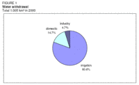 Figure 1. Water withdrawal. (Source: FAO)
 Major water users in the country are the domestic sector, irrigation, hydropower, industry, navigation, recreation and tourism, fisheries, and biodiversity. Water withdrawal for agricultural and domestic purposes has increased over the last decade as a result of socio-economic development and population growth. Agriculture/irrigation is still by far the major water-withdrawing sector, followed by the domestic and municipal water supply and industry (Table 2 and Figure 1). However, an updated and comprehensive water resources and water use information database is not available in the country.
International Water Issues
A great part of Malawi’s water resources, such as Lake Malawi, Lake Chilwa, Lake Chiuta, and Shire, Ruo and Songwe Rivers are shared with the neighboring countries of Mozambique and the United Republic of Tanzania as trans-boundary and cross-boundary waters. So far, no major conflicts have arisen over the utilization of these resources. However, in order to avoid potential conflicts, Malawi is signatory to a number of international treaties and conventions, including the SADC Protocol on Shared Watercourses and the 1997 UN convention of non-navigational uses of international waters.
At a bilateral level, Malawi is implementing a project for the stabilization of the Songwe River course jointly with the United Republic of Tanzania, through the Malawi/the United Republic of Tanzania Joint Permanent Commission of Cooperation (JPCC). The agreement on the establishment of a Joint Water Commission between Malawi and Mozambique has been signed in November, 2003. With Lake Malawi and the Shire River system being a sub-basin of the Zambezi watercourse, Malawi actively participates in the Zambezi Watercourse Commission (ZAMCOM), which was signed by the eight riparian member states of the Zambezi River Basin in July 2004 in Kasanne, Botswana. Within the SADC region, Malawi is part of other initiatives such as the SIDA initiative and the FAO (Food and Agriculture Organization (FAO))-supported Convention on the Management of Lake Malawi/Nyasa for Sustainable Development.
Irrigation and Drainage Development
Evolution of Irrigation Development
The total potential for irrigation was estimated in the early 1990s to be 161,900 ha, including the existing dambos. Other estimates range from 200,000 ha for formal irrigation up to 480,000 ha for informal irrigation. The potential for small-scale irrigation is estimated at 100,000 ha. Most of the potentially irrigable land lies in the plains along the shores of Lake Malawi in Karonga and Nkhotakota - Salima, the Lake Chilwa Plain, the Lower Shire Valley and the flood plain of the Limphasa River in Nkhata Bay. Of these, the Lower Shire Valley has the greatest potential for irrigation development in the country. These areas have fertile soils and adequate water resources for the development of irrigated agriculture.
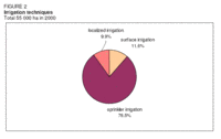 Figure 2. Irrigation techniques. (Source: FAO)
 Irrigated agriculture in Malawi started in the late 1940s with the development of the Limphasa Irrigation Scheme in the Nkhata Bay District. In the mid-1950s, two more schemes were established in the Chilwa Phalombe Plain and an irrigated crop research station was developed at Makhanga. In 1965 the Sugar Corporation of Malawi (SUCOMA) started the production of sugar cane under irrigation. Further irrigation development took place between 1968 and 1979 when 16 schemes with a total irrigable area of 3,600 ha were constructed by the government, with a view to increasing rice production and, amongst other objectives, to serve as training grounds for farmers in irrigation skills. These government schemes are located in Karonga, Mzuzu, Salima, Machinga, and Ngabu Agricultural Development Divisions (ADDs).
In 2000, the total area equipped for full or partial control irrigation was 55,000 ha, with almost 80 percent being under sprinkler irrigation (Figure 2). Almost all irrigation is from surface water. Some small lakeshore areas are irrigated by groundwater. In 2002, an estimated 56,390 ha were equipped (Table 3). Of these, 48,135 ha belonged to estates cultivating sugar cane, tea, and coffee under irrigation. Sugar cane is the main irrigated crop, followed by tea (Figure 3). Other irrigated crops include rice and vegetables in smallholder schemes. Currently the yields for rice in the government-owned irrigation schemes are as low as 1 tonne/ha, and improving irrigation efficiency should be a priority concern for the government.
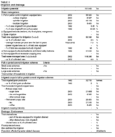 Table 3. Irrigation and drainage. (Source: FAO)
 Irrigation schemes in Malawi can be categorized into four main groups:
- Private large commercial schemes (> 100 ha), such as the Nchalo and Dwangwa sugar estates and Kawalazi coffee estates, are mostly owned by foreign investors, such as Illovo, Commonwealth Development Corporation (CDC), etc.
- Private small commercial schemes owned by individuals (< 100 ha).
- Government-operated smallholder schemes established by the government to give irrigation opportunities to local small-scale farmers at almost no cost. The farmers pay no water charges.
- Self-help smallholder schemes run by the farmers themselves on a self-help basis or in certain cases by non-governmental organizations (NGOs).
The Department of Irrigation (DoI) uses the following, informal classification for its work: small schemes have a gross area of less than 50 ha, medium schemes are between 50 and 500 ha and large schemes are over 500 ha. Within each of these size classes there are differences depending on how the scheme is farmed and managed. Therefore, DoI subdivides the schemes as follows:
- Informal schemes: developed by farmers themselves, with limited or no technical input to design;
- Semi-formal schemes: received some kind of technical support and are usually farmer-initiated self-help schemes;
- Formal schemes: planned, designed and built according to technical standards and by professionally trained staff; they include both smallholder and estate schemes and many schemes that were in the public domain in the past.
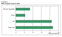 Figure 3. Main irrigated crops in 2002. (Source: FAO)
 In 1997, the construction of the Bwanje Valley Irrigation Development Project commenced with grant aid from Japan. The 800 ha scheme was developed by the JICA and aimed at enabling 2,240 smallholder farmers to produce rice and other crops for food security and economic development at household level among others. It included works in the basin of the Namikokwe River, which were the largest scale construction works on irrigation facilities in Malawi so far. There are, however, critical voices saying that instead of the implemented diversion that leads river water into the canal, a dam would have been far more efficient, since during the dry period large parts of the scheme cannot be irrigated because of the reduced river flow.
The oldest traditional irrigation method used in the country is the watering can. It is probably the cheapest and simplest technology and hence most widely used by smallholder farmers in self-help schemes. Since about 1998, the DoI has introduced several irrigation technologies targeting smallholder farmers, including motorized pumps, river diversions, and manual pumps (treadle pumps). The demand for the latter is reported to be high: by 2001 Malawi had imported 10,000 treadle pumps. The Ministry of Agriculture introduced motorized and treadle pump schemes for employees to purchase the pumps on loan. The use of motorized pumps is widely common, especially by the estates and private commercial farmers. In 2001 the Malawi Project Inc., with support from Healing Hands International, purchased 3,000 drip irrigation systems and organized the training of Malawians as instructors. As a result, two and in some cases three crop harvests were brought in from the drip program farms. The area of non-equipped wetlands (dambos) was estimated at 61,900 ha in 1992 (Table 3).
Role of Irrigation in Agricultural Production, the Economy, and Society
Large-scale commercial estate production of sugar cane under irrigation is well established in the Chikwawa and Nkhotakota Districts. Supplementary irrigation of tea and coffee is used on estates in Thyolo, Mulanje, and Nkhata Bay. Smallholder schemes are mainly used for growing rice, vegetables, and maize (Table 3). In the wetlands (dambos), simple irrigation is used for vegetable and rice production.
Over the last 15 years, irrigation has had a low priority in agricultural production. The main constraints have been:
- Focusing of the agricultural economy on rainfed agriculture and existing irrigation schemes, where emphasis was on funding extension activities;
- Reluctance of donors to fund irrigation development;
- Replacement of irrigation services under the Ministry of Agriculture, which has focused on rainfed agriculture;
- Price setting for crops not viable for irrigation;
- Almost no irrigation technology training facilities within the country;
- A poorly funded and understaffed Department of Irrigation;
- Lack of farmer ownership of plots on government schemes.
Over a considerably long period, informal irrigation in the country has been growing steadily to supplement all other efforts by the government, as well as the private sector, to improve the food availability and security situation. At the same time individuals have benefited as a source of regular income for their households comes from the sale of their produce.
Water Management, Policies, and Legislation Related to Water Use in Agriculture
Institutions
The development of irrigated agriculture is supported by several institutions including the Ministry of Agriculture and Irrigation (MAI), the Ministry of Water Development (MWD), the Department of Environmental Affairs, the Water Resources Board, the Department of National Parks and Wildlife, the Department of Forestry and training institutions.
The Department of Irrigation (DoI), which is part of the MAI, has in the past been responsible for the actual implementation of irrigation activities. Now, the responsibility for developing irrigation projects rests with the beneficiary community, and the DoI plays the role of a facilitator. It is the duty of the Department to provide advisory services in the development of irrigation programs in the country. The Department consists of a Head Office and eight Agricultural Development Divisions (ADDs). One task of the ADDs is to manage irrigation schemes directly. The problems of the DoI are that it is heavily understaffed and that most of the present staff require training in irrigation technology.
The central function of the MWD is to facilitate the development and management of water resources in the country. Among its responsibilities are ensuring access to safe water and related sanitation services, the provision of safe drinking water to rural communities the collection of hydrological data and catchment protection. It has been noted that the link between the DoI and the MWD is very weak and needs to be strengthened.
The Water Resources Board is an institution within the MWD and is responsible for the granting of water rights for abstractions and discharge of effluents, as well as for monitoring the adherence to the water rights. For the development of irrigation schemes, water rights for abstraction and discharge of wastewater drained from irrigation schemes have to be granted by the Board.
The primary function of the Department of Environmental Affairs is to ensure that the implementation of projects does not result in the degradation of the environment. For all irrigation schemes of more than 10 ha, environmental impact assessments are conducted.
The Department of National Parks and Wildlife and the Department of Forestry are responsible for the protection of catchment areas that fall within their jurisdiction. Some of the [[river]s] that are diverted for irrigation purposes arise from areas designated as national parks/game reserves or forest reserves and therefore, there is a need for collaboration between these departments and the Department of Irrigation.
Water Management
Both the Irrigation Act 2001 and the Water Resources Act 1969 provide for the formation of water user associations or irrigation management authorities to promote local community or farmers’ participation in the development and management of irrigation and drainage, and proper utilization of the available water resources.
By 1999, the ADDs directly managed over 40 irrigation schemes. These are mainly smallholder irrigation schemes for rice production developed in the 1960s and 1970s. However, the level of farmers’ involvement in the operation and maintenance of the irrigation schemes has been limited and their experience in scheme and water management is thus very low. This has been attributed to the top-down approaches used in the development and management of these schemes, which were initiated, designed, constructed and managed by the Government, without farmers’ participation in the development process. To improve the situation, the DoI is currently transferring responsibility to the local smallholder farmers and empowers them to manage the schemes by themselves. To this effect, the DoI initiated the formation of water user associations or other farmer organizations, such as Trusts and Cooperatives, for a number of irrigation schemes.
The Government considers that extension services, especially those targeted at smallholder farmers, should remain part of its core functions. There is, however, a strong argument for partially commercializing extension and research services, in particular those delivered to the medium and large farmers who have the capacity to pay. The approach has in fact been tried with the irrigation and coffee trust, but it is too early to gauge its success.
Finances
Government policy on financing irrigation developments in the country is that such developments are only minimally subsidized. The government aims to optimize its investment in irrigation development through the application of the principles of cost sharing and cost recovery.
Policies and Legislation
Policy issues are addressed by the National Irrigation Policy and Development Strategy (2000) developed by the DoI, the Water Policy (1996), the Water Resources Management Policy and Strategy (2000) developed by the MWD, and the Environmental Management Policy (1996). Main legislation concerned with issues of water resources and irrigation are the Water Resources Act of 1969 and the Irrigation Act of 2001.
According to the Irrigation Policy and Development Strategy, the mission of the DoI is to manage and develop water and land resources for diversified, economically sound and sustainable irrigation and drainage systems under organized smallholder and estate management institutions and to maintain an effective advisory service. Following this policy, an Irrigation Act (No. 16 of 2001) was passed by Parliament in November 2001. The Act makes provision for the sustainable development and management of irrigation, protection of the environment from irrigation related degradations, establishment of a National Irrigation Board and for matters connected therewith or incidental thereto.
The overall policy goal of the Water Resources Management Policy and Strategy is [[sustainable] management] and utilization of water resources in order to provide water of acceptable quality in sufficient quantities, and ensure availability of efficient and effective water and sanitation services that satisfy the basic requirements of every Malawian. The Policy is currently being revised to include a number of issues that were not clearly addressed in the previous policy documents.
Under the Water Resources Act of 1969 all water abstractions must be licensed, except for general household domestic use, as well as all industrial effluent discharges into public water bodies, including human sewage. Annual permits are required for abstractions greater than 1,000 L/day, except for domestic use. The charging system is based on the water source and type of usage; however, the collection of revenue is severely limited by lack of staff. Together with the efforts to revise the above policy there are attempts to revise and amend the Water Resources Act of 1969. The process of the revision of the Act has been very slow. In fact efforts to revise the Act started in the mid 1980s but they never materialized due to a number of factors. However, following recent revision of the policy, efforts are underway to finally amend the Act. The existing Act makes provision for the control, apportionment and use of the country’s water resources.
Environment and Health
The quality of the water resources in Malawi is dependent on three major factors:
- Chemical composition of the parent rocks existing in the area;
- Extent of agricultural activities (application of agrochemicals, farming practices, land husbandry);
- Disposal of industrial waste products as well as human sewage, particularly in urban areas.
Generally both surface water and groundwater are acceptable for human consumption. However, due to recently increased agricultural activities, there has been considerable degradation of water resources as a result of increased siltation in [[river]s] and reservoirs. This is most severe in areas that are under immense population pressure, resulting in serious deforestation and cultivation of marginal and other fragile areas. Groundwater is more mineralized in alluvial aquifers than in the weathered basement aquifers. Areas such as the lower Shire Valley, eastern Bwanje valley and around Lake Chilwa have saline waters. As such the utilization of groundwater in such areas is limited due to high contents of iron, fluoride, sulphates, nitrates (Nitrogen), and Total Dissolved Solids (TDS).
Irrigation development in Malawi has not had any very serious negative environmental impacts. Most of the areas that have been developed for irrigation have for as long as people can remember been considered waterlogged areas for most of the year. As a result the impact of irrigation development in terms of waterlogging is minimal.
Water-related vector-borne diseases such as malaria, typhoid, cholera, and bilharzia have infected most people around the irrigation schemes in Malawi. In order to reduce the spread and intensification of such diseases, most of the schemes, and particularly those operated by the government, include a water supply and sanitation component to provide for potable water through sinking of boreholes, and proper sanitation facilities. In addition, health clinic facilities are provided to provide treatment for the affected population as well as health hygiene and education. However, there are quite a number of schemes, and especially self-help schemes, where such facilities are lacking.
Perspectives for Agricultural Water Management
Since 1994 the new Government has realized the importance of irrigation as a means of ensuring food security at both household and national levels. This has been demonstrated by raising the status of irrigation to Ministry level and recent Government pronouncements suggest that irrigation will be the cornerstone of the country’s agricultural development strategy. The new Ministry has put forward a 23-point irrigation development strategy plan for poverty alleviation. Its main features are to:
- Give highest priority to the development of irrigation and water resources and strengthen the MAI with sufficient funds and staffing to undertake studies on pumping sites, boreholes, and dam development;
- Establish a National Committee on Irrigation and Drainage and promote irrigation research;
- Recommend power lines be installed along [[river]s] and the lakeshore to encourage irrigation development and agro-industries;
- Facilitate arrangements for the provision of input support to small farmers, including credit facilities;
- Increase the development of self-help farmer schemes, and hand over operation and management of existing government-run schemes following completion of rehabilitation;
- Support irrigation development in the private sector, and support smallholder farms with irrigation technology and diversified cropping systems;
- Provide training at field and management levels and assist farmers in the organization of water user associations to ensure that future irrigation development is socially and economically viable;
- Ensure women’s participation at all levels and ensure adequate health standards on schemes;
- In close collaboration with other relevant Ministries and organizations, ensure the enforcement of legislation on water conservation and catchment protection;
- Strengthen monitoring activities to ensure projects are executed as planned.
The MAI (1999) had identified unreliable water supplies as a main restriction to developing irrigation and presented the following strategies to overcome the problem:
- More small earth-dams will be constructed over [[river]s] to create reservoirs for use in irrigation farming. The dams will not only guarantee availability of water for crops during the dry season and drought periods, but they will also control floods by retaining excess runoff during heavy storms thereby protecting crops from flood damage.
- Catchment areas of rivers supplying water to irrigation schemes and fragile areas such as riverbanks and wetlands will be protected. This is necessary because, due to the encroachment upon catchment areas by human activities, such as agricultural production and settlements, most of the land has been devoid of vegetation cover thus preventing adequate amounts of rainwater from infiltrating into the ground to recharge aquifers and causing soil erosion leading to serious siltation problems and choked canals.
- Environmental impact assessments will be conducted on all irrigation schemes of more than 10 ha.
- Alternative sources of water supply will be exploited. In this respect, groundwater resources should be developed for irrigation. This also applies to water from Lake Malawi, which will be tapped using canals or pumps to irrigate areas along the lakeshore. Areas between Liwonde and Mangochi and between Karonga Boma and Songwe would benefit from such irrigation projects.
- Imported "orphan" pumps, i.e. pumps for which spare parts are not locally available and which farmers cannot repair, will not be used for irrigation.
In 2002/2003, the MAI revised its irrigation development program for the next five years. This development program prioritizes irrigation development aimed at increasing agricultural productivity and at the same time at promoting the use of appropriate and simple irrigation technologies. The program focuses largely on the use of treadle pump technology by smallholder farmers, with the objective of considerably increasing the coverage of irrigation development in the country. It is planned that an estimated 300,000 treadle pumps will be installed for smallholder farmers until 2008, and that an estimated 495 km of canals will be built over the same period. Other technologies, such as river impoundments and the use of small motorized pumps, will be exploited further. It is planned that by the end of 2008 at least 100,800 ha of irrigation development will be added to the current status. To achieve this development goal, a total of almost US$78 million would be required to cover the procurement of 300,000 treadle pumps, the construction of 495 km canals, the procurement of 2,000 small motorized pumps and other equipment (bulldozers, excavators) and the provision of extension services.
The country is blessed with large water bodies, [[river]s], lakes, and dambo wetlands, and there is large scope for sustainable production expansion under irrigation. There is considerable scope for expanding rice production in Malawi under irrigation, but there is also a high potential for the production of high value crops, other than rice, for the export and domestic [[market]s] under irrigated agriculture.
Further Reading
- African Development Fund. 1998. Smallholder Irrigation Project. Appraisal Report. Republic of Malawi.
- AHT International GMBH. 2001. Smallholder Floodplains Development Programme. Final Technical Assistance Report. Republic of Malawi, Ministry of Agriculture and Irrigation and IFAD.
- Chavula, G.M.S. and Chirwa, A.B. 1998. Impacts of Climate Change on Water Resources in Malawi: A Vulnerability Assessment and Adaptation Strategies.
- Chirwa, A.B. 2001. Natural Resources Management in Malawi. Final Report.
- Department of Environmental Affairs. 1998. State of Environment Report for Malawi 1998.
- Department of Environmental Affairs. 2001. State of Environment Report 2001.
- Department of Environmental Affairs. 2002. National Environmental Action Plan 2002.
- Department of Irrigation. 2000. Irrigation Development Report: Reporting Period 1994 - 1999.
- Department of Irrigation. 2002. Sub-sector Studies for Irrigation - Institutional Development, Part 1: Socio-economic Aspects of Irrigation Technologies in Malawi, and Part 2: Irrigation and Environmental Planning and Irrigation and Health Planning.Draft Final Reports.
- FAO. 1985. Smallholder Irrigation in Malawi. Project Findings and Recommendations. Terminal Report of project MLW/80/013.
- Geheb, K., and Sarah, M.T. (eds.). 2002. Africa’s inland fisheries: the management challenge. Fountain Publishers. Kampala.
- Government of Malawi. 2001. Irrigation Act (No. 16 of 2001).
- Hunting Technical Services. 1986. Irrigation Study Phase II: Feasibility Studies. Final Report, Vol. 4, Annex: Self-Help Schemes.
- ICID (International Commission on Irrigation and Drainage). Sprinkler and Micro-Irrigated Areas in some ICID Member Countries.
- Kaluwa, P.W.R., Mtambo, F.M. and Fatch, R. 1997. The Country Situation Report on Water Resources in Malawi. UNDP/SADC Water Initiative.
- Ministry of Agriculture and Irrigation. 1999. Review of Malawi Agricultural Policies and Strategies.
- Ministry of Agriculture and Irrigation. 2000. National Irrigation Policy and Development Strategy.
- Ministry of Agriculture and Irrigation. 2003. Simple Priority Irrigation Programs.
- Ministry of Agriculture and Livestock Development. 1994. The Agricultural and Livestock Development Strategy and Action Plan.
- Ministry of Water Development. 1999. Water Resources Management Policy and Strategies.
- Ministry of Water Development. 2002. Joint Sector Review of Malawi Water and Sanitation Sector, Issues and Priorities.
- Mzembe, C.P. 1994. Overview of Irrigation Development in Malawi.
- SADCC (Southern African Development Coordination Conference). 1992. Regional Irrigation Development Strategy. Country Report Malawi.
- UNDP. 1986. National Water Resources Master Plan. Projects MLW 79/015 & MLW/84/003. Department of Water, Ministry of Works and Supplies.
- World Bank. 1994. Water Services Sector Study. Final Report, prepared by Cowiconsult A/S and Norconsult A/S.
- World Bank. 1994. National Water Development Project - Project Document. Cowiconsult A/S and Norconsult A/S.
- Water Profile of Malawi, Food and Agriculture Organization.
- World Factbook: Malawi, Central Intelligence Agency.
<center>
| Disclaimer: This article is taken wholly from, or contains information that was originally published by, the Food and Agriculture Organization. Topic editors and authors for the Encyclopedia of Earth may have edited its content or added new information. The use of information from the Food and Agriculture Organization should not be construed as support for or endorsement by that organization for any new information added by EoE personnel, or for any editing of the original content.
|
</center>
</center>
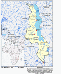 Map of Malawi. (Source: FAO)