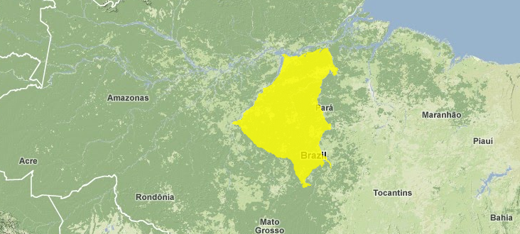
Tapajós-Xingu moist forests
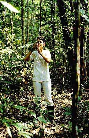
Tapajos National Forest, Brazil Photograph by WWF/ J. Natalino
This ecoregion lies between the Tapajós and Xingu rivers that flow within the Amazon Basin of central-eastern Brazil.
Characterized by a high density of lianas (woody vines), which create a low, open understory, this region hosts an impressive level of biodiversity; over one hundred and sixty species of mammals are found here and more than five hundred and fifty species of avifauna.
With few protected areas, the Transamazon Highway transects this ecoregion and has increased the level of urbanization, timber extraction, and gold mining.
Contents
Location and General Description
The Tapajós-Xingu moist forest ecoregion lies in central-eastern Brazil south of the Amazon River, comprising the interfluvial plain between the Tapajós and Xingu Rivers, both major tributaries to the Amazon River. The region extends southward to the base of the Serra do Cachimbo in the southwest corner of the Brazilian State of Pará. These hills separate this watershed from the neighboring Madeira-Tapajós moist forest. The region mostly lies on the well-weathered Brazilian Shield, formed one billion years ago, which provides a hard crystalline basement. The environment is heterogeneous with undulating terrain and numerous smaller rivers that dissect the interfluve. The largest of these rivers is the Rio Iriri, which flows into the Xingu River. Others include the Jamanxim, Curuá, Crepori, Curuá-una, and Jarauçu. These are all stable blackwater rivers, those which carry few or no suspended sediments, and whose banks sometimes flood creating white-sand igapó forest. Some soils are eutrophic, or nutrient-rich, in many areas. But other areas are characterized by oligotrophic soils on the uplands, meaning they are poor in nutrients. Elevations range from 5 meters (m) on the Amazon River to 200 m in the uplands to the south. Annual rainfall in middle Xingu is 1,500 to 2,000 millimeters (mm).
 Source: WWF
Topographic variability begets biological heterogeneity in the Tapajós-Xingu region, and where there are eutrophic soils they sustain a rich and diverse biota with a high occurrence of endemism. The forests are generally evergreen tropical rain forest on terra firme (non-flooded land). They are characterized by patches of dense submontane forest in a matrix of open-canopy submontane forest. Lowland forest occurs just along the Amazon River. The Tapajós-Xingu region hosts a peculiar forest type characterized by a high density of lianas (woody vines). These liana forests occupy thousands of square kilometers on the high relief in the south and southeast portion of the region. These are typically open forests that occur on richer soils with a lower (less than 25 m) and more open canopy than the typical humid terra firme forest. The difference between these and the more typical open forest is that in these forests many huge woody vines occur throughout the forest strata. Their presence gives this forest a structural complexity unequaled elsewhere.
The most important family containing lianas is Bignoniaceae, followed by Leguminosae, Hippocrateaceae, Menispermaceae, Sapindaceae, and Malpighiaceae. Nevertheless, these forests host large trees such as Apuleia molaris, Bagassa guianensis, Caryocar villosum, Hymenaea parvifolia, Tetragastris altissima, Astronium graveolens, A. le-cointei, Apuleia leiocarpa var. molaris, Sapium marmieri, Acacia polyphylla, and Elizabetha sp.
Brazil nut trees (Bertholletia excelsa) and mahogany (Swietenia macrophylla) are also found here. Numerous endemic trees and vines occur, including Cenostigma tocantinum, Ziziphus itacaiunensis, and Bauhinia bombaciflora. Zollernia paraensis, a leguminous tree, Theobroma grandiflorum, a fruit similar to cacao called cupuaçu, and Cordia goeldiana, a common timber tree, are all well-known in eastern Pará. They reach their western limit at the Tapajós River. Along the clearwater Tapajós River, the white-sand igapó forest is predominant with members of the Myrtaceae family and Triplaris surinamensis, Piranhea trifoliata, Copaifera martii, and Alchornea castaneaefolia. The famous pau d’arco roxo, Tabebuia ipe, a valuable timber tree, is common there.
Biodiversity Features
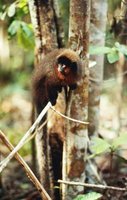 Titi monkey. (Photograph by WWF-Canon/Edward Parker)
 The fauna of the region includes 161 species of mammals and 556 species of birds. The Tapajós River is a barrier to the distribution of animals, plants, and insects. For example, the white-fronted capuchin (Cebus albifrons) and saki (Pithecia hirsutus) occur on the west-side of the river but not on the east, while the bearded saki (Chiropotes albinasus) only occurs on the east. The tiny titi monkey (Callicebus moloch) also occurs here, and the gray-necked night monkey (Aotus infulatus) and spider monkey (Ateles marginatus) are endemic to this and the interfluve to the east. River wildlife includes the spectacled caiman (Caiman crocodilus), black caiman (Melanosuchus niger), yellow-spotted sideneck turtle (Podocnemis unifilis), American manatee (Trichechus inunguis), and river dolphins (Ina geoffroyensis, Sotalia fluviatilis).
Other large mammals include white-lipped peccaries (Tayassus pecari), collared peccaries (T. tajacu), pumas (Puma concolor), panthers (Panthera onca), tapir (Tapirus terrestris), and brocket deer (Mazama spp.). The many interesting birds found here include ospreys (Pandion haliaetus), harpy eagles (Harpia harpyia), toucans (Ramphastos vitellinus), little chachalacas (Ortalis motmot), nine tinamous (Crypturellus spp., Tinamus spp.), seven macaws (Ara spp.) including hyacinth macaws (Anodorhynchus hyacinthinus) which live in few other places, many parakeets (Paratinga spp., Pyrrhura spp., Brotogeris spp.), parrots (Amazona spp., Pionus spp.), and hoatzins (Opisthocomus hoazin).
Current Status
The Transamazon Highway and road south to Cuiabá traverse the Tapajós-Xingu moist forest region. Along these roads, colonization, logging, ranching, and large-scale development projects result in large-scale deforestation and land degradation. Urban centers here include Altimira on the Iriri River, Santarém at the mouth of the Tapajós, and Aveiro on the Lower Tapajós. Very few protected areas are established here. The Amazonia National Park straddles the Tapajós River near Itaituba covering 9,935 km2 but suffers from inadequate administrative capacity. Tapajós National Forests offers little protection to the forests near Aveiro.
Types and Severity of Threats
Rapid expansion of the helter-skelter development patterns along roads and riverways with increasing colonization pose the greatest threat to the environment and its inhabitants. Large anthropogenic fires that often burn out of control threaten the remaining forests and environment in terms of both habitat loss (Land-use and land-cover change) and degradation of water and air quality. Timber extraction also has degraded many of the forests near the Madeira River and the highways. Mining for gold and other minerals continues to threaten aquatic life and to destroy landscape elements. This is considered a frontier region where continued development poses a major threat to the wildlife and ecological integrity. The remaining forests are severely threatened by human activities.
Justification of Ecoregion Delineation
This interfluvial ecoregion is bound by the Tapajós River to the west, the Xingu River to the east and the Solimões (Amazon) River and várzea to the north. These three very large rivers act as formidable barrier to the dispersal of many species, and the ecoregion thus hosts a number of endemic species. The linework follows the IBGE classifications of "lowland dense ombrophilous forest", "submontane dense ombrophilous forest", and "submontane open ombrophilous forest" within the parameters of these rivers. To the south this ecoregion abuts to distinct seasonal forest – savanna transition.
Additional Information on this Ecoregion
- For a shorter summary of this entry, see the WWF WildWorld profile of this ecoregion.
- To see the species that live in this ecoregion, including images and threat levels, see the WWF Wildfinder description of this ecoregion.
- World Wildlife Fund Homepage
Further Reading
- Ducke, A., and G. A. Black. 1953. Phytogeographical notes on the Brazilian Amazon. Anais da Academia Brasileira de Ciências 25: 1-46.
- Fundação Instituto Brasilero de Geografia Estatástica-IBGE. 1993. Mapa de vegetação doBrasil. Map 1:5,000,000. Rio de Janeiro, Brazil.
- Gentry, A. H. 1991. The distribution and evolution of climbing plants. Pages 3-49 in J. Putz and H. Mooney, editors, The biology of vines. Cambridge: Cambridge University Press. ISBN: 0521392500
- Pires, J. M. 1984. The Amazonian forest. Pages 581-602 in H. Sioli, editor, The Amazon: Limnology and landscape ecology of a mighty tropical river and its basin. Junk, Dordrecht. ISBN: 9061931088
- Prance, G. T., and K. S. Brown Jr. 1987. The principle vegetation types of the Brazilian Amazon. Pages 30-31 in T. C. Whitmore and G. T. Prance, editors, Biogeography and Quaternary History in Tropical America. Oxford: Clarendon Press. ISBN: 0198545460
- Silva, J.M. C. 1998. Um método para o estabelecimento de áreas prioritárias para a conservação na Amazônia Legal. Report prepared for WWF-Brazil. 17 pp.
| Disclaimer: This article is taken wholly from, or contains information that was originally published by, the World Wildlife Fund. Topic editors and authors for the Encyclopedia of Earth may have edited its content or added new information. The use of information from the World Wildlife Fund should not be construed as support for or endorsement by that organization for any new information added by EoE personnel, or for any editing of the original content. |