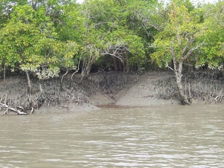
Sundarbans
Contents
- 1 Sundarbans, Bangladesh
- 1.1 Date and History of Establishment
- 1.2 Map of Bangladesh. (Source: University of Texas Libraries)
- 1.3 Area
- 1.4 Land Tenure
- 1.5 Altitude
- 1.6 Physical Features
- 1.7 Climate
- 1.8 Vegetation
- 1.9 Fauna
- 1.10 Cultural Heritage
- 1.11 Local Human Population
- 1.12 Visitors and Visitor Facilities
- 1.13 Scientific Research and Facilities
- 1.14 Conservation Value
- 1.15 Conservation Management
- 1.16 IUCN Management Category
- 1.17 Further Reading
Sundarbans, Bangladesh
The Sundarbans (21°30'- 22°30'N, 89°12'-90°18'E) are a World Heritage Site which consists of three wildlife sanctuaries (Sundarbans West, East and South) lying on disjunct deltaic islands in the Sundarbans Forest Division of Khulna District, close to the border with India and immediately west of the principal outflow of the Ganges, Brahmaputra and Meghna rivers. The Sundarbans belong to Bengalian Rainforest biogeographical province.
Date and History of Establishment
- 1977: All three wildlife sanctuaries established under the Bangladesh Wildlife (Preservation) (Amendment) Act, 1974,
- 1878: The three sanctuaries gazetted as forest reserves.
- 1996: The total area of wildlife sanctuaries extended; the entire Sundarbans is reserved forest, established under the Indian Forest Act, 1878.
- 1997: The Sundarbans inscribed on the World Heritage List.
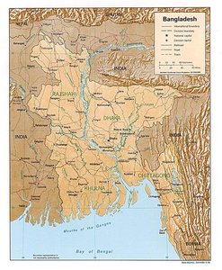 Map of Bangladesh. (Source: University of Texas Libraries)
Area
The total area of the Bangladesh section of Sundarbans is 595,000 hectares (ha) of which 139,699ha are protected as follows: Sundarbans West Wildlife Sanctuary with 71,502ha; Sundarbans East Wildlife Sanctuary with 31,226 hectares; and Sundarbans South Wildlife Sanctuary with 36,970ha. Sundarbans National Park (133,010 hectares), a World Heritage Site, is situated to the west in India.
Land Tenure
The Sundarbans are entirely state owned.
Altitude
Ranges from sea level to three meters in elevation
Physical Features
The Sundarbans, covering some 10,000 square kilometers of land and water, is part of the world's largest delta (80,000sq.km) formed from sediments deposited by three great rivers, the Ganges, Brahmaputra and Meghna, which converge on the Bengal Basin. The total area of the Bangladesh Sundarbans is 5771 square kilometres (nearly 62 percent of the total), of which 4071 square kilometres is land and the balance is covered by water. This area is approximately half the size of the area of mangroves (Sundarbans mangroves) that existed two centuries earlier, the other half suffering habitat destruction, having beencleared and converted to agricultural land.
The land is molded by tidal action, resulting in a distinctive physiography. An intricate network of interconnecting waterways, of which the larger channels of often a mile or greater in width extend in a generally north-south direction, intersects the whole area. Innumerable small khals drain the land at each ebb.
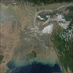 The combined delta of the Ganges and Brahmaputra Rivers is the largest in the world. This true-color image from the Moderate-resolution Imaging Spectroradiometer (MODIS) shows both the delta and sediment flowing into the Bay of Bengal. (Source: Earth Observatory of NASA)
 Rivers in this ecoregion tend to be long and straight, a consequence of the strong tidal forces and the clay and silt deposits which resist erosion. Easily eroded sands collect at the river mouths and form banks and chars, which are blown into dunes above the highwater mark by the strong southwest monsoon. Finer silts are washed out into the Bay of Bengal but, where they are protected from wave action, mud flats form in the lee of the dunes. These become overlain with sand from the dunes, and develop into grassy middens. This process of island building continues for as long as the area on the windward side is exposed to wave action. With the formation of the next island further out, silt begins to accumulate along the shore of the island and sand is blown or washed away. Apart from Baleswar River the waterways carry little freshwater as they are cut off from the Ganges, the outflow of which has shifted from the Hooghly-Bhagirathi channels in India progressively eastwards since the 17th century. They are kept open largely by the diurnal tidal flow.
Alluvial deposits are geologically very recent and quite deep. The soil is a silty clay loam with alternate layers of clay, silt and sand. The surface is clay except on the seaward side of islands in the coastal limits, where sandy beaches occur. In the eastern part of the Sundarbans the surface soil is soft and fertile, whereas it is harder and less suitable for tree growth in the west . The potential of hydrogen (pH) averages 8.0, or slightly basic.
Climate
Rainfall is heavy and humidity high (80%) due to the proximity of the Bay of Bengal. About 80% of the rain fall in the monsoon, which lasts from June to October. Mean annual rainfall varies from about 1,800 millimeters (mm) at Khulna, north of the Sundarbans, to 2,790mm on the coast. There is a six-month dry season during which evapotranspiration exceeds precipitation. Conditions are most saline in February-April, the depletion of soil moisture being coupled with reduced freshwater flow from upstream. Temperatures rise from daily minima of 2-4 degrees Celsius (°C) in winter to a maximum of about 43°C in March and may exceed 32°C in the monsoon. Storms are common in May and October-November and may develop into cyclones, usually accompanied by tidal waves of up to 7.5 meters (m) high. Climatic data for Khulna are summarised by Christensen.
Vegetation
The mangroves of the Sundarbans are unique when compared to non-deltaic coastal mangrove forest. Unlike the latter, the Rhizophoraceae are of only minor importance and the dominant species are sundri Heritiera fomes, from which the Sundarbans takes its name, and gewa Excoecaria agallocha. The reason for this difference is the large freshwater influence in the north-eastern part and the elevated level of the ground surface. The Sundarbans can be classified as moist tropical seral forest, comprising a mosaic of beach forest and tidal forest. Of the latter, there are four types: low mangrove forests, tree mangrove forests, salt-water Heritiera forests and freshwater Heritiera forests. Sundarbans West occurs within the salt-water zone, which supports sparse Ecoecaria agallocha, a dense understory of Ceriops, and dense patches of hantal palm Phoenix paludosa on drier [[soil]s]. Dhundal and passur Xylocarpus spp., and Bruguiera occur sporadically throughout the area. Sundri and gewa cover most of the Sundarbans but Oryza coarctata, Nypa fruticans, and Imperata cylindrica are prevalent on mud flats. Large stands of keora Sonneratia apetala are found on newly accreted mudbanks and provide important wildlife habitat.
Prain gives an account of the flora of the mangrove forest of the Ganges-Brahmaputra delta. Seidensticker and Hai report a total of 334 plant species, representing 245 genera, present in the Bangladesh portion of the delta, and list principal woody and herbaceous species. Chaffey and Sandom provide a detailed list of trees and shrubs in the Bangladesh portion. Islam provides an account of the algal flora of the mangroves.
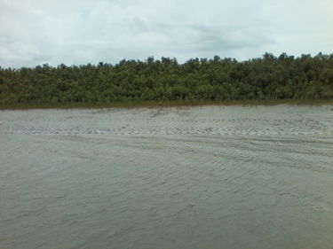 Coastal mangrove vegetation (Source: Saikat Basu, own work) Coastal mangrove vegetation (Source: Saikat Basu, own work)
|
 Tidal creeks adjoining mangrove belts (Source: Saikat Basu, own work) Tidal creeks adjoining mangrove belts (Source: Saikat Basu, own work)
|
Fauna
The Sundarbans is the only remaining habitat in the lower Bengal Basin for a variety of faunal species. The presence of 49 mammal species has been documented. Of these, no less than five spectacular species, namely Javan rhinoceros Rhinoceros sondaicus (CR), water buffalo Bubalus bubalis (EN), swamp deer Cervus duvauceli (VU), gaur Bos frontalis (VU) and probably hog deer Axis porcinus (LR) have become locally extirpated since the beginning of this century. The only primate is rhesus macaque Macaca mulatta, considered by Blower to number in the region of 40,000 to 68,200, based on surveys by Hendrichs and Khan, respectively, as compared to the much higher estimate of 126,220 derived by Gittins.
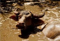 Water buffalo; Type: Mammal; Diet: Herbivore; Size: Head and body, 8 to 9 feet (2.4 to 2.7 m); Tail 2 to 3.3 feet (60 to 100 cm); Weight: 1,500 to 2,650 lbs (700 to 1,200 kg).
The domesticated water buffalo is often referred to as the “living tractor of the East,” as it is relied upon for plowing and transportation in many parts of Asia. The water buffalo, or Asian buffalo, as it is often called, is the largest member of the Bovini tribe, which includes yak, bison, African buffalo, various species of wild cattle, and others. (Source: National Geographic)
.The Sundarbans of Bangladesh and India support one of the largest populations of the Tiger (Panthera tigris) (EN), with an estimated 350 in that of the former. Again, Gittins' estimate of 430-450 tigers may be overoptimistic. Spotted deer Cervus axis, estimates of which vary between 52,600 and 80,000, and wild boar Sus scrofa, estimated at 20,000, are the principal prey of the tiger, which also has a notorious reputation for man-eating. Of the three species of otter, smooth-coated otter Lutra perspicillata (VU), estimated to number 20,000, is domesticated by fishermen and used to drive fish into their nets. Other mammals include three species of wild cat, Felis bengalensis, F. chaus and F. viverrina, and Ganges River dolphin Platanista gangetica (EN), which occurs in some of the larger waterways. Species accounts and a check-list are given by Salter.
The varied and colourful bird-life to be seen along its waterways is one of the Sundarbans' greatest attractions. A total 315 species have been recorded, including about 95 species of waterfowl and 38 species of raptors. Among the many which may be readily seen by the visitor are no less than nine species of kingfisher, including brown-winged and stork-billed kingfishers, Pelargopsis amauropterus (NT) and P. capensis, respectively; the magnificent white-bellied sea-eagle Haliaeetus leucogaster which, at a density of one individual per 53.1 kilometers (km) of waterways, is quite common; also the much rarer grey-headed fish eagle Ichthyophaga ichthyaetus (NT), Pallas's fish-eagle Haliaeetus leucoryphus and several other raptors. Herons, egrets, storks, sandpipers, whimbrel, curlew and numerous other waders are to be seen along the muddy banks and on the chars or sandbanks which become exposed during the dry season. There are many species of gulls and terns, especially along the coast and the larger waterways. Apart from those species particularly associated with the sea and wetlands, there is also a considerable variety of forest birds such as woodpeckers, barbets, shrikes, drongos, mynahs, minivets, babblers and many others. Scott gives further details of the avifauna.
Some 53 reptile species and eight of amphibians have been recorded. Of these mugger Crocodylus palustris (VU) is now extinct, probably as a result of past over-exploitation, although it still occurs in at least one location nearby. Estuarine crocodile C porosus still survives but its numbers have been greatly depleted through hunting and trapping for skins. There are also three species of monitor, Varanus bengalensis, V. flavescens and V. salvator, and Indian python Python molurus (NT). Four species of marine turtle have been recorded from the area, olive ridley Lepidochelys olivacea (EN) being the most abundant. Green turtle Chelonia mydas (EN) is rare due to excessive fishing, while loggerhead Caretta caretta (EN) and hawksbill Eretmochelys imbricata (CR) are not common although there have been some reported on the beaches. River terrapin Batagur baska (EN) is also present. The eighteen recorded snake species include king cobra Ophiophagus hannah and spectacled cobra Naja naja, three vipers and six sea-snakes.
Over 120 species of fish are reported to be commonly caught by commercial fishermen in the Sundarbans. According to Mukherjee only brackish water species and marine forms are found in the Indian Sundarbans, freshwater species being totally absent. This may be assumed to apply also to the Bangladesh Sundarbans, except possibly in the eastern portion where there is freshwater (Freshwater biomes) in Baleswar River. Mention should also be made of mud-skippers or gobys which occur in large numbers and are a characteristic feature of mangrove swamps.
Crustacea account for by far the largest proportion of animal biomass, with an estimated 40 million kilograms (kg) of fiddler crabs and 100 million kilograms of mud crabs. The nutrient-rich waters of the Sundarbans also yield a considerable harvest of shrimps, prawns and lobsters. The area supports a varied insect population including large numbers of honey-bees, honey and beeswax being among the economically important products. The insect life of the Sundarbans has been little studied.
Cultural Heritage
There is archaeological evidence of earlier human occupation on the deltaic islands. The human settlements are indicative of the former presence of abundant freshwater (Freshwater biomes), both from the Ganges and from non-saline groundwater. Human occupation ceased in the 17th century, reportedly due to pirate attacks.
Local Human Population
Approximately 2.5 million people live in small villages surrounding the Sundarbans. The area provides a livelihood at certain seasons of the year for an estimated 300,000 people, working variously as wood-cutters, fishermen, and gatherers of honey, golpatta leaves (Nipa fruticans) and grass.
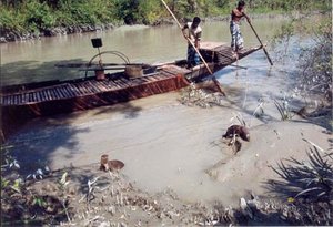 Fishermen are catching fish with the help of otters (Lutra percipicilata) in the Sundarbans of Bangladesh. (Source: Ramsar)
 Fishermen come in their boats from as far away as Chittagong and establish temporary encampments at various sites along the coast, where they remain until the approach of the monsoon season in April before returning to their homes. Apart from the large numbers of people employed by contractors in the commercial exploitation of sundri and other tree species, the local people are themselves dependent on the forest and waterways for such necessities as firewood, timber for boats, poles for house-posts and rafters, golpatta leaf for roofing, grass for matting, reeds for fencing and fish for their own consumption. The season for collecting honey and wax is limited to two and a half months commencing annually on 1 April. Thousands of people, having first obtained their permits from the Forest Department, enter the forest in search of bee nests which are collected and then crushed to extract the honey and wax.
Visitors and Visitor Facilities
Few tourists visit the Sundarbans due to the difficulty and cost of arranging transport and to the lack of suitable accommodation and other facilities. The area has no potential for mass tourism but it does offer obvious possibilities for limited special-interest tourism from October to April or May. The use of launches equipped with catering and sleeping facilities is considered more practicable than permanent land-based facilities and would provide greater flexibility. There is, however, a large well-equipped rest house belonging to the Port Authority at Hiron Point, Sundarbans South Wildlife Sanctuary, and a smaller one belonging to the Forest Department at Katka in Sundarbans East Wildlife Sanctuary.
Scientific Research and Facilities
Considerable research has been carried out on the Sundarbans ecosystem and its wildlife. Hendrichs undertook a three-month field study of tiger, concentrating on the problem of man-eating, and other vertebrates and invertebrates, in 1971. Other faunal surveys include those of Gittins and Khan for rhesus macaque, Khan for spotted deer, Sarker and Sarker for birds, and Sarker and Sarker and Sarker for birds of prey. About 500 foreign tourists visited the area in 1996 plus 5000 domestic tourists, the majority at the South Wildlife Sanctuary.
Conservation Value
The mangrove forest (Sundarbans mangroves)s of the Sundarbans are among the richest and most extensive in the world. The Bangladesh portion, covering six percent of total land area, represents over half of the country's remaining natural forest. The forests and waterways support a wide range of fauna, including a number of species threatened with extinction. As one of the most biologically productive of all natural [[ecosystem]s], it is of great economic importance as a source of timber, fish and numerous other products.
Conservation Management
Three field stations have been established within Sundarbans West. There are no recognized local rights within the reserved forest, entry and collection of forest produce being subject to permits issued by the Forest Department. The Department may issue hunting licenses under the Bangladesh Wildlife (Preservation) (Amendment) Act, 1974, but in practice none is issued and the whole Sundarbans is thus effectively closed to legal hunting. Under the provision of this Act, various activities are prohibited within the wildlife sanctuaries, including inter alia residence, cultivation of land, damage to vegetation, hunting, introduction of domestic animals and setting of fires. Any of these prohibitions may be relaxed, however, for scientific purposes, aesthetic enjoyment or "improvement" of scenery.
The Sundarbans is the only sizeable mangrove forest (Sundarbans mangroves) in the world managed for commercial timber production and it has been under some sort of management since 1879. Early management consisted on revenue collection by enforcing simple felling rules. Subsequently, the progressive enforcement of felling rules reduced the amount of over-cutting of the four species for which felling rules were established. Bangladesh part of Sundarbans is managed as a continuous block of mangrove forest with no permanent human habitation inside.
The Sundarbans has been the subject of a series of successively more comprehensive working plans since its declaration as reserved forest, the most recent of which points out the importance of the tiger in controlling the spotted deer population, and also mentions the intention of establishing compartments 3-7 as a 'game sanctuary', a total area of some 52,320ha. A plan relating specifically to wildlife conservation was prepared under the joint sponsorship of the World Wildlife Fund (WWF) and the National Zoological Park, Smithsonian Institution. Emphasis is directed towards managing the tiger, together with all wildlife, as an integral part of forest management that assures the sustainable harvesting of forest products and maintains this [[coastal] zone] in a way that meets the needs of the local human population. The Sundarbans Forest Development Planning Mission, carried out by Food and Agriculture Organization (FAO) in conjunction with the Bangladesh Forest Department in February-May 1984, collected all available data related to the use and management of forest products, wildlife and fisheries, assessed development potential and prepared proposals for further integrated development and conservation of the natural resources of the area. More recently, Blower reviewed wildlife conservation in the Sundarbans Reserved Forest as part of the Sundarbans Forest Inventory Project, carried out by the Bangladesh Forest Department and the Land Resources Development Centre of the UK Overseas Development Administration. The main purpose of the project is to provide the necessary data on which to base future exploitation of the forest for sustainable use of timber, fuelwood and other forest produce, with due consideration to wildlife conservation and the social amenity value of the area. It has been recommended that the Sundarbans be managed as a single unit with full protection afforded to both wildlife and habitat in the wildlife sanctuaries, and with forest resources exploited at sustainable levels but wildlife protected elsewhere in the reserved forest. The establishment of intermediate buffer zones, in which disturbance is kept to a minimum through restriction of access, is recommended in areas peripheral to sanctuary boundaries. A new management plan is due to be prepared, based on data collected in 1995, and is expected to include detailed prescriptions concerning the conservation and management of the sanctuaries.
Management Constraints
A long-term ecological change is taking place in the Sundarbans, due to the eastward migration of the Ganges, abandonment of some distributaries, diversion of water and withdrawals for irrigation. (Up to 40% of the dry season flow of the Ganges has been diverted upstream, following the completion of the Farraka Barrage in India in 1974.) Decreased freshwater flushing of the Sundarbans results in increased saline intrusion, particularly in the dry season. Concern has been expressed about recent indications of apparent deterioration in the flora, including localised die-back of sundri, commercially the most valuable of tree species. Top-dying of sundri is most likely associated with the decrease in freshwater flow, either as a direct effect of increasing salinity or other associated edaphic changes. A gradual replacement of Heritiera with Excoecaria, therefore, is a likely long-term effect. While deterioration in the vegetation is already well-documented and is the subject of continuing study, no attention has yet been given to the possible effects which these changes might have on the fauna. It is perhaps significant, however, that the stocking of spotted deer appears lower in western areas, where salinity is highest, than in the east where it is lowest. Oil spills are another potential threat and could cause immense damage, especially to aquatic fauna and seabirds and probably also to the forest itself. There have been several spillages from tanks passing nearby. The most recent incidence due to ship wreckage occurred in August 1994 when a Panamanian cargo ship capsized near Dangmari Forest Station. Oil from the fuel tank spread about 15km downstream from the ship and affected a considerable part of the Sundarbans mangrove area. It was found to cause instant mortality of seedlings of Heritiera and Excoecaria while patches of grass which were covered by oil also died. Mortality of fishes, shrimps and other aquatic animals from the Sundarbans has been reported to due the incidence.
Cyclones and tidal waves cause some damage to the forest along the sea-face, and are reported to result occasionally in considerable mortality among spotted deer. The most immediate threat is over-exploitation, both of timber resources, which may have already taken place, and also of the fauna. Agricultural encroachment has already occurred to a limited extent on the eastern and western boundaries and, with increasing population pressure in surrounding settled areas, could reach serious proportions unless checked. Fishermen's camps are a major source of disturbance. There is extensive illegal hunting and trapping, not only by fishermen and woodcutters but also reportedly by naval and military personnel from Hiron Point in Sundarbans South Wildlife Sanctuary. A total of 118 offenses was recorded and over 3,300m of deer nets removed between 1981/82 and 1986/87, but this poaching is now rare. The capture of adult marine turtles and Batagur in fishing nets and their subsequent killing and marketing for food is a potentially serious problem. Smugglers moving to and from India with contraband goods also use the area.
The Sundarbans has been notorious for its man-eating tigers since the 17th century. Numbers of reported deaths has varied from 0 to 47 (mean = 22.1) per annum during the period 1947-1983. In 1988, 65 deaths were reported during a four-month period. Noting that tigers that hunt man like any other prey occurred only in the south and west, Hendrichs hypothesized on a possible linkage between high salinity levels, due to the absence of freshwater (Freshwater biomes), and man-killing. This is not substantiated by more recent analyses, which suggest that man-killing may be at least partly correlated with the availability of easy prey (humans) and the frequency of man-tiger interactions.
Staff
There are three field stations in Sundarbans West Wildlife Sanctuary each with 95 staff (2 officers and 7 forest guards). There are respectively two stations in South Wildlife Sanctuary and three in South East Wildlife Sanctuary.
Budget
No information available
IUCN Management Category
- Sundarbans East, West and South Wildlife Sanctuaries IV (Managed Nature Reserve)
- Natural World Heritage Site - Criteria ii, iv
Further Reading
- Blower, J. (1985). Sundarbans Forest Inventory Project, Bangladesh. Wildlife conservation in the Sundarbans. Project Report 151. Overseas Development Administration, Land Resources Development Centre, Surbiton, UK. 39 pp.
- Chaffey, D. R. and Sadom, J.H. (1985). Sundarbans Forestry Inventory Project. A glossary of vernacular plant names and a field key to trees. Overseas Development Administration, Land Resources Development Centre, Surbiton, UK. 23 pp.
- Champion, H. G. (1936). A preliminary survey of the forest types of India and Burma. Indian Forest Record (New Series) 1: 1-286.
- Choudhury, A. M. (1968). Working plan of the Sundarban Forest Division for the period from 1960-61 to 1979-80. Vol. I. Government of East Pakistan, Forest Department, Dacca. 82 pp.
- Christensen, B. (1984). Ecological aspects of the Sundarbans. FO: TCP/BGD/2309 (Mf). FAO, Rome. 42 pp.
- Gittins, S. P. (1981). A survey of the primates of Bangladesh. Unpublished report. Fauna Preservation Society, London. 64 pp.
- Habib, M. G. (1989). Wildlife management of the Sundarban - a case study. In: Karim, G.M.M.E., Akonda, A.W. and Sewitz, P. (Eds), Conservation of wildlife in Bangladesh. German Cultural Institute/Forest Department/Dhaka University/Wildlife Society of Bangladesh/Unesco, Dhaka. Pp. 161-168.
- Hendrichs, H. (1975). The status of the tiger Panthera tigris (Linne, 1758) in the Sundarbans mangrove forest (Bay of Bengal). Saugetierkundliche Mitteilungen 23: 161-199.
- Hussain, K. Z. and Acharya, G. (eds.) (1994). Mangroves of the Sundarbans. Volume two: Bangladesh. IUCN, Bangkok, Thailand. ISBN: 2831702100.
- Husain, K. Z. Sarker, S. U. and Rahman, M. M. (1983). Summer birds of the Sundarbans' 'Nilkamal Sanctuary', Bangladesh. Bangladesh Journal of Zoology 11(1): 48-51.
- International Engineering Company (1980). Southwest regional plan. Bangladesh Water Development Board, Dacca.
- Khan, M. A. R. (1986). Wildlife in Bangladesh mangrove ecosystem. Journal of the Bombay Natural History Society 83: 32-48.
- Mukherjee, A. K. (1975). The Sundarbans of India and its biota. Journal of the Bombay Natural History Society 72: 1-20.
- Nazrul Islam, A. K. M. N. (1973). The algal flora of the Sundarbans mangrove forests, Bangladesh. Bangladesh Journal of Botany 2(2): 11-36.
- Olivier, R. C. D. (1979). Wildlife and management in Bangladesh. UNDP/FAO Project No. BGD/72/005. Forest Research Institute, Chittagong. 121 pp.
- Salter, R. E. (1984). Integrated development of the Sundarbans, Bangladesh: status and utilization of wildlife. FO: TCP/BGD/2309(MF). Report No. W/R0034. FAO, Rome. 59 pp.
- Sarker, S. U. (1985a). Ecological observation on the endangered whitebellied sea eagle Haliaeetus leucogaster (Gmelin) in the Sundarbans, Bangladesh. In: Symposium on endangered marine animals and marine parks. Vol. 4. Endangered and/or vulnerable other marine invertebrates and vertebrates. Paper No. 58. Marine Biological Association of India, Cochin.
- Sarker, S. U. (1985b). Density, productivity and biomass of raptorial birds of the Sundarbans, Bangladesh. Proceedings of SAARC Seminar on Biomass Production, 15 April 1985, Dhaka. Pp. 84-92.
- Sarker, S. U. and Sarker, N. J. (1985). Birds of prey and their conservation in the Sundarbans mangrove forests, Khulna, Bangladesh. ICBP Technical Publication No. 5. Pp. 205-209.
- Sarker, S. U. and Sarker, N. J. (1986). Status and distribution of birds of the Sundarbans, Bangladesh. The Journal of Noami 3: 19-33.
- Scott, D. A. (Ed.) (1989). A Directory of Asian wetlands. IUCN, Gland, Switzerland and Cambridge, UK. 1,181 pp. ISBN: 2880329841.
- Seidensticker, J. and Hai, M. A. (1983). The Sundarbans Wildlife Management Plan: conservation in the Bangladesh coastal zone. IUCN, Gland, Switzerland. 120 pp.
- Siddiqi, N. A. and Choudhury, J. H. (1987). Man-eating behaviour of tigers (Panthera tigris Linn) of the Sundarbans - twenty-eight years' record analysis. Tigerpaper 14(3): 26-32.
| Disclaimer: This article is taken wholly from, or contains information that was originally published by, the United Nations Environment Programme-World Conservation Monitoring Centre (UNEP-WCMC). Topic editors and authors for the Encyclopedia of Earth may have edited its content or added new information. The use of information from the United Nations Environment Programme-World Conservation Monitoring Centre (UNEP-WCMC) should not be construed as support for or endorsement by that organization for any new information added by EoE personnel, or for any editing of the original content. |
