Southern Ocean
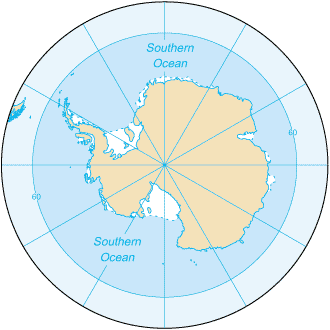
Seas of the World  The Southern Ocean surrounds Antarctica extending to the latitude 60° South. It is sometimes referred to as the Antarctic Ocean (a counterpart to the Arctic Ocean) or the South Polar Ocean.
The Southern Ocean has the unique distinction of being a large circumpolar body of water totally encircling the continent of Antarctica.
This ocean region occupies about 4% of the Earth's surface or about 20,327,000 square kilometers (7,846,000 square miles). It has 17,968 km of coastline.
Seas adjacent or part of this ocean region include the Amundsen Sea, Bellingshausen Sea, Ross Sea, Scotia Sea, and the Weddell Sea.
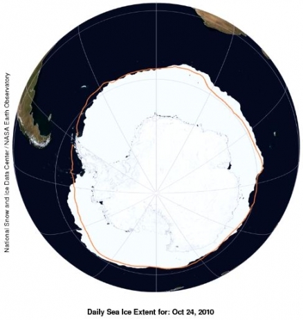
By about September of each year, a mobile icepack situated around Antarctic reaches its greatest seasonal extent covering about 19 million square kilometers (7 million square miles). This icepack shrinks by around 85% six months later in March.
Probable large and possible giant oil and gas fields exist on the continental margin. Other natural resources include manganese nodules, possible placer deposits, sand and gravel, fresh water as icebergs; squid, whales, seals, krill, and fish.
There are few ports or harbors exist on the southern side of the Southern Ocean; ice conditions limit use of most to short periods in midsummer; even then some cannot be entered without icebreaker escort; most Antarctic ports are operated by government research stations and, except in an emergency, are not open to commercial or private vessels.
Contents
Northern Boundary
The northern boundary of the Southern Ocean is not precisely defined. The International Hydrographic Organization (IHO) tentatively set the boundary at the latitude of 60°south in 2000, but has not formally adopted that boundary. The decision of the (IHO) on a boundary addressed a long term dispute about whether the waters around Antarcica should be considered merely southern extensions of the Atlantic, Indian and Pacific Oceans. In adopting its position on the Southern Ocean, Commodore John Leech of the IHO, articulated the rationale for recognizing the ocean:
"A great deal of oceanographic research in recent years has been concerned with ocean circulations, first because of El Nino, and then because of a wider interest in global warming...Research has identified that one of the main drivers of ocean systems is the 'Southern Circulation,' which sets the Southern Ocean apart as a separate eco-system. As a result the term Southern Ocean has been used to define that huge body of water which lies south of the northern limit. Thinking of this body of water as various parts of the Atlantic, Indian and Pacific Oceans makes no scientific sense. New national boundaries arise for geographical, cultural or ethnic reasons. Why not a new ocean, if there is sufficient cause?"
Some oceanographers tend to prefer the Antarctic Convergence, or the boundary between water masses and currents of the oceans to the north (Atlantic, Indian and Pacific Oceans), as the northern limit of the Southern Ocean. While the Antarctic Convergence is approximately at the latitude of 60°south, it moves seasonally and thus provides challenges as a useful boundary to chartographers and others.
The latitude of 60°south coincides with the Antarctic Treaty Limit, the international treaty governing Antarctica.
Australia has argued that the Southern Ocean extends north of the IHO definition south of that country, extending all the way to Australia's southern shore. This assertion is not generally recognized.
Ice
The Southern Ocean includes huge icebergs with drafts up to several hundred meters as well as smaller bergs and iceberg fragments. Many of these derive from the numerous Antarctic Ice Shelves, whose named formations amount to 47.
Sea ice, most often one half to one meter thick, with sometimes dynamic short-term variations and with large annual and interannual variations; covers much of the ocean. The Antarctic icepack grows from an average minimum of 2.6 million sq km in March to about 18.8 million sq km in September, better than a sixfold increase in area. In winter the ocean freezes outward to 65 degrees south latitude in the Pacific sector and 55 degrees south latitude in the Atlantic sector, lowering surface temperatures well below 0 degrees Celsius; at some coastal points intense persistent drainage winds from the interior keep the shoreline ice-free throughout the winter.
Climate
Sea temperatures vary from about 10 degrees Celsius to -2 degrees Celsius.
Cyclonic storms travel eastward around the continent and frequently are intense because of the temperature contrast between ice and open ocean. The ocean area from about latitude 40 south to the Antarctic Circle has the strongest average winds found anywhere on Earth.
Ecology
The Antarctic Convergence concentrates nutrients, which promotes marine plant life, and which in turn allows for a greater abundance of animal life.
Water Masses and Currents
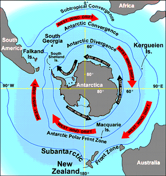
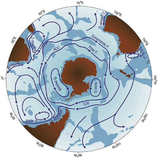 Schematic diagram of the Antarctic Circumpolar Current (ACC). Source: Science in Salamanca
A large body of recent oceanographic research has shown that the Antarctic Circumpolar Current (ACC), an ocean current that flows from west to east around Antarctica, plays a crucial role in global ocean circulation. The Antarctic Circumpolar Current (21,000 km in length) is the world's largest ocean current, transporting 130 million cubic meters of water per second - 100 times the flow of all the world's rivers.
The region where the cold waters of the ACC meet and mingle with the warmer waters of the north defines a distinct border - the Antarctic Convergence - which fluctuates with the seasons, but which encompasses a discrete body of water and a unique ecologic region.
The major chokepoint is the Drake Passage between South America and Antarctica.
Bathymetry
Relative to the other ocean regions, the floor of the Southern Ocean is quite deep ranging from 4,000 to 5,000 meters (13,100 to 16,400 feet) below sea level over most of the area it occupies.
Continental shelf areas are very limited and are mainly found around Antarctica. But even these areas are quite deep with an elevation between 400 to 800 meters (1,300 to 2,600 feet) below sea level.
For comparison, the average depth of the continental shelf for the entire planet is about 133 meters (425 feet). The Southern Ocean's deepest point is in the South Sandwich Trench at 7,235 meters (23,3737 feet) sea level.
Lowest point: -7,235 m at the southern end of the South Sandwich Trench.
Environmental problems and governance
The Southern Ocean has experienced increased solar ultraviolet radiation resulting from the Antarctic ozone hole in recent years, reducing marine primary productivity (phytoplankton) by as much as 15% and damaging the DNA of some fish.
Illegal, unreported, and unregulated fishing has occurred in recent years, especially the landing of an estimated five to six times more Patagonian toothfish than the regulated fishery, which is likely to affect the sustainability of the stock. There is a large amount of incidental mortality of seabirds resulting from long-line fishing for toothfish.
The now-protected fur seal population is making a strong comeback after severe overexploitation in the 18th and 19th centuries.
The Southern Ocean is subject to all international agreements regarding the world's oceans; in addition, it is subject to these agreements specific to the Antarctic region:
- International Whaling Commission (prohibits commercial whaling south of 40 degrees south of 60 degrees between 50 degrees and 130 degrees west);
- Convention on the Conservation of Antarctic Seals (limits sealing);
- Convention on the Conservation of Antarctic Marine Living Resources (regulates fishing)
Many nations (including the US) prohibit mineral resource exploration and exploitation south of the fluctuating Polar Front (Antarctic Convergence).
The Antarctic Treaty defers claims in Antarctica, but Argentina, Australia, Chile, France, New Zealand, Norway, and the Unietd Kingdom assert claims (some overlapping), including the continental shelf in the Southern Ocean; several states have expressed an interest in extending those continental shelf claims under the United Nations Convention on the Law of the Sea (UNCLOS) to include undersea ridges; the United States and most other states do not recognize the land or maritime claims of other states and have made no claims themselves (the US and Russia have reserved the right to do so); no formal claims exist in the waters in the sector between 90 degrees west and 150 degrees west
Further Reading
- PhysicalGeography.net
- Antarctic Oceanography, Chapter 6 of Tomczak, Matthias & J Stuart Godfrey: Regional Oceanography: an Introduction 2nd edn (2003) ISBN: 8170353068
- Southern Ocean, CIA World Factbook
- Canberra all at sea over position of Southern Ocean, Andrew Derby, The Age, December 22, 2003
