Sinú Valley dry forests
For its location at the northwestern extreme of the Andes, near the Darien-Panama bridge and between the two major ecoregions: Chocó wet forests and Magdalena Medio rain forests, the Sinú region is a bridge, a genetic corridor, a contact zone and a center of endemism, and it is strongly believed, a paleo-environment. The altitudinal gradient, from the upper peaks of the Paramillo, at 3.960 meters (m) above sea level (masl.) to the low alluvial valley at 200 masl. and to the mangroves at sea level, makes it possible for the region to have several types of ecosystems and forests in within a relatively small area.
Contents
Location and General Description
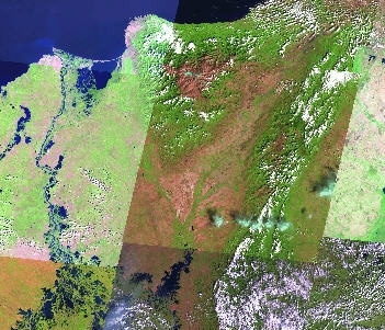
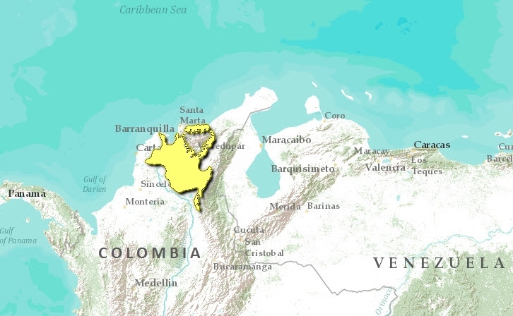
Located in the northern sector of Colombia and the South American continent ( between 7° N, 75° W and 10° N, 77° W ), and surrounded by the Magdalena moist forest, the Sinú river flows from the northernmost branches of the western Cordillera of the Andes, towards the Caribbean sea, forming a valley between the Serranías de Abibe and San Jerónimo and finally forming an alluvial plain of quaternary origin. The Sinú river and its main upper tributaries the Verde and the Esmeraldas, originate in the Nudo de Paramillo, with a maximum height of 3.960 meters above sea level. The alluvial plain, today mostly converted to agriculture and cattle ranching, has many swamps and wetlands and several thousand years ago might have been covered by jungles until the establishment of the Zenú culture, that lasted until the arrival of the Spanish. The Zenú transformed the landscape into agricultural lands and savanna, but moist forests cover the upper parts in the mountains that form the valley.
The Sinú Valley has one of the most fertile soils in Colombia, due to the annual floods of the Sinú River, which together with a seasonal climate, has developed a rich and endemic flora within an ecosystem very abundant in wildlife. Moist forests and the Caribbean sea to the north surround this seasonal dry region. It was the place of origin of the now extinct indigenous Zenú culture, famous for its advanced agricultural channels and its gold work.
The rainfall is highly seasonal, with a dry period between January and March, and the rainy season between April and December, with a short dry period around June. An average of 1,100 to 1,500 millimeters (mm) of rain falls in the region per year, being the southern parts of the valley wetter than the north. The average annual temperature is between 82° F and 86° F.
Today the valley is covered by grasslands for cattle ranching with introduced grass species like Bracchiaria spp. and indigenous grasses as Andropogon spp. Agriculture is mainly commercial today, with such crops as cotton, soybean, rice, papaya, and watermelon. Dispersed in the grasslands are trees of Crecentia cujete, Ceiba pentandra, Lecythis minor, Ochroma pyramidale, Prosopis juliflora, Cavanillesia platanifolia and palms trees of Sabal mauritiiformis, Acrocomia aculeate, Attalea butyracea and several Bactris spp. Last century, many valuable timber species formed extensive jungles of tremendous tree size, but today are almost extirpated, among them were Swietenia macrophylla, Cedrela odorata, Caesalpinia ebenum, Cariniana pyriformis, Tabebuia chrysantha, Bombacopsis sp., Aspidosperma sp. and others. Several orchids are found growing on these trees: Caularthron bicornutum, Oncidium obrizatum and the highly endangered Cattleya aurea. The valley is also known for the huge variety of native and introduced tropical fruits: Achras sapota, Manilkara achras, Chrysophyllum caimito, Pouteria cainito, Persea americana, Mammea americana, Anacardium occidentale, Carica papaya, Annona muricata, Manguifera indica and more.
Biodiversity Features
The region is known for its tremendous [[rich]ness] in terms of biodiversity, due to the amount of species and level of endemism, the diversity of ecosystems present within the ecoregion, the situation as a corridor between South America and the Isthmus of Panamá, and as contact region between the Chocó and the Magdalena Medio.
Due to the amount of wetlands, as lagoons, marshes, swamps, and mangroves to the coast, and its location in the northernmost part of the continent, the valley is the place of arrival of many migratory species of birds of prey, waterfowl, and songbirds during the northern winters. These include the osprey (Pandion haliaetus) and wild ducks such as Anas discors, Anas cyanoptera, Anas acuta, Anas clypeata and Anas americana. Also, important populations of native waterfowl and fishes, inhabit this wetlands. Among these are Chauna chavarria, Cairina moschata, Sarkidiornis melanotos, Dendrocygna autumnalis, Dendrocygna bicolor, and important fishes such as Brycon moorei, Ichthyoelephas longirostris, Prochilodus reticulatus, Petenia krausii, and Tarpon atlanticus. The largest rodent, Hydrochaeris hydrochaeris, the manatee (Trichechus manatus), and the caiman (Crocodylus acutus), live in these wetlands also.
The savanna deer (Odocoileus virginiaunus gymnotis), lives together with the puma (Puma concolor), and several other carnivores such as the crab-eating raccoon (Procyon cancrivorous) and the jaguarundi (Herpailurus yaguaroundi). in the open grasslands taking refuge in the forest patches remaining and along the water currents.
In the moist forest surrounding the valley, and in the upper Sinú, where there are wetter conditions, the forests are very rich in wildlife; it is the only place known where two tapir species are sympatric, Tapirus bairdii and Tapirus terrestris colombianus; also here are found: spectacled bear (Tremarctos ornatus), giant anteater (Myrmecophaga tridactyla), jaguar(Panthera onca), ocelot (Leopardus pardalis), brocket deer (Mazama americana), spider monkey (Ateles geoffroyi), cotton top tamarin (Saguinus oedipus), and white-lipped peccary (Tayassu pecari), among mammals, and the largest eagle the harpy (Harpia harpyja), the endemic curassow (Crax alberti), the great green macaw (Ara ambigua), all of them endangered. Many more species of birds, reptiles, amphibians ,and arthropods are known to occur here, but it is, biologically, one of the least known ecoregions of Colombia.
Besides being the only Colombian region to have naturally grown mahogany (Switenia macrophylla), the Colombian ebony (Caesalpinia ebenum) is endemic to the drier parts of this ecoregion. Another endemic is the golden Cattleya orchid, (Cattleya aurea), that is sympatric in the upper Sinú with the gigas Cattleya orchid, (Cattleya warscewickzii), showing the contact zone between Magdalena Medio and Chocó-Darién; the upper Sinú is the only place where the naturally occurring hybrid, the spectacular (Cattleya X hardyana) has been found.
Species of special concern for this ecoregion are the [[Colombia]n] ebony and the mahogany, among the precious timber; the Cattleya aurea, as this beautiful orchid has suffered from over-collection for more than seventy years; the two species of tapirs present are highly endangered both at the national and international level; the harpy eagle and the blue-billed curassow are also endangered species than still present in the upper Sinú.
Current Status
Due to recent large-scale human intervention, of no more than sixty years, mainly deforestation for cattle ranching and agriculture, damming of the river for large hydroelectric projects, and desiccation of wetlands, very few intact habitat remains in the low valley or in the drier ecosystems, but around it, in the mountains and in the upper Sinú, the forest cover stills present and the presence of a National Park and Indigenous territories assures its conservation.
Wetlands and swamps are at different levels of intervention, but most still in good conditions, until now, when a new dam is filling up in the upper Sinú. The aquatic ecosystems are in need of conservation actions.
Types and Severity of Threats
The recent construction of large dams for hydroelectric power, the Urrá I and II, is going to affect the seasonal floods of the valley, which in turn replenish the wetlands and swamps with fresh water and nutrients, affecting the productivity of the ecosystem and the reproduction of fishery. It will also affect the "Subienda" or up-going of the fishes to spawn by the physical barrier the dam itself is. An indigenous group of Embera people, proper to the upper Sinú, have their ancestral territories in there, and are being badly affected by the intervention of outsiders.
The construction of the Urrá II Project affected the ancestral lands of the Emberá indigenous people by floods and deforestation.
Justification of Ecoregion Delineation
Originally designated as a Pleistocene refuge by Dr. Jorge Hernández Camacho of Colombia, in Hernández-Camacho, J. et al. 1992, this dry forest in northern Colombia in flanked by the Cordillera Oriental of the northern Andes to the east, and the Caribbean to the northwest. This is a region of great climatic transition. The southern delineation follows the transition to moist forests and the northern delineation the transition to xeric desert. Thus the linework here is porous and represents the climatic regime of potential dry forests in this area. As very little of the original vegetation here remains, we relied on expert opinion during a regional priority setting workshop for ecoregions of the Northern Andes.
Further Reading
- Complejo Ecoregional de los Andes del Norte (CEAN). Experts and ecoregional priority setting workshop. Bogota, Colombia, 24-26, July, 2000.
- Dahl, George. 1985. Jaguar. 2 ed. Universidad Nacional de Colombia, Colección Popular, Bogotá, Colombia.
- Gordon, B. Le Roy., 1983. El Sinú, Geografía Humana y Ecología. Bogotá, Colombia: Carlos Valencia Editores., Bogotá, Colombia.
- Hilty, S. L., and W. L. Brown. 1986. A guide to the birds of Colombia. Princeton, New Jersey: Princeton University Press, Princeton, New Jersey, USA. ISBN: 069108372X
- Hernández Camacho, J.,; G. A. Hurtado, G., A.; Q. R. Ortiz, y T. Walschburger. 1992. Unidades bBiogeográficas de Colombia in G. Halffter, editor, La Diversidad Biológica de Iberoamérica. CYTED-D, Acta Zoológica Mexicana, Xalapa, México. ISBN: 9687213310
- Miles, C.Cecil, 1971. Los Peces del Río Magdalena. Ibagué, Colombia: Universidad del Tolima Ediciones, Ibagué, Colombia.
| Disclaimer: This article is taken wholly from, or contains information that was originally published by, the World Wildlife Fund. Topic editors and authors for the Encyclopedia of Earth may have edited its content or added new information. The use of information from the World Wildlife Fund should not be construed as support for or endorsement by that organization for any new information added by EoE personnel, or for any editing of the original content. |

