Sian Ka'an Biosphere Reserve, Mexico
| Topics: |
Contents
- 1 Introduction The Reserva de la Biosfera de Sian Kan'an (19°05'-20°06'N, 87°30'-87°58'W) is a World Heritage Site located in Mexico (Sian Ka'an Biosphere Reserve, Mexico) in the biogeographical province of Campechean/Yucatecan.
- 2 Geographical Location
- 3 Date and History of Establishment
- 4 Area
- 5 Land Tenure
- 6 Altitude
- 7 Physical Features
- 8 Climate
- 9 Vegetation
- 10 Fauna
- 11 Cultural Heritage
- 12 Local Human Population
- 13 Visitors and Visitor Facilities
- 14 Scientific Research and Facilities
- 15 Conservation Value
- 16 Conservation Management
- 17 IUCN Management Category
- 18 Further Reading
Introduction The Reserva de la Biosfera de Sian Kan'an (19°05'-20°06'N, 87°30'-87°58'W) is a World Heritage Site located in Mexico (Sian Ka'an Biosphere Reserve, Mexico) in the biogeographical province of Campechean/Yucatecan.
Geographical Location
Situated (19°05'-20°06'N, 87°30'-87°58'W) on the eastern side of the Yucatan Peninsula in the State of Quintana Roo (municipalities of Solidaridad and Felipe Carrillo Puerto). Where possible, boundaries were defined to coincide with natural features: bounded by the Caribbean Sea and the barrier reef to a depth of 50 meters (m) in the east; the junction between the marshes and semi-evergreen forests in the south-east; and the junction of Chetumal and Espiritu Santo Bays catchment basin in the south. Political boundaries in the north and north-east are defined by the border of Pino Suarez and Chunyaxché farming cooperatives. The northern sites can be reached by a dirt track from Tulum, while Punta Pajaros is only accessible by boat or airplane.
Date and History of Establishment
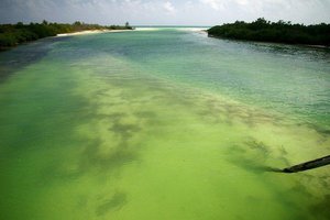 Biosphere Reserve of Sian Ka'an, located in state of Quintana Roo, Yucatán Peninsula, Mexico.. (Source: Wikimedia Commons)
 Sian Ka'an was declared a national biosphere reserve on 20 January 1986 by the Federal Government, and was recognized as an international Biosphere Reserve by the MAB International Coordinating Council in late 1986. Inscribed on the World Heritage List in 1987.
Area
528,000 hectares (ha): 408,000 ha are terrestrial; and 120,000 ha are marine. The core zone of the MAB reserve covers 279,704 ha, and comprises two terrestrial areas and one marine area. Contiguous to Uaymil Protected Area (89,118 ha) in the south.
Land Tenure
94% is under federal ownership, 3% comprises communal lands, and 3% is privately owned.
Altitude
Sea level to 10 m.
Physical Features
Sian Ka'an lies on a partially emerged coastal limestone plain which forms part of the extensive barrier reef system along the eastern coast of Central America. Much of the reserve lies in a zone of recent Pleistocene origin which still appears to be in a transitional stage. A large series of sink holes (cenotes) exist in the area and are characteristic features of the Yucatan and Florida peninsulas. The hydrological cycle is complex and the water table is permanently close to the surface (never deeper than 8 m). As a result, each year during the dry season, about 20% of the terrestrial part of the reserve remains flooded. This figure increases to about 75% by the end of the rainy season. There is little surface running water within the reserve as it usually filters fairly rapidly through the shallow rendzina and 'saskab' (granular whitish and brittle limestone) soils, and the limestone rock to subterranean channels. Due to their hardness, the waters in the reserve are generally very clear. A geological fault crosses the reserve from the south-west to the north-east influencing its topography and hydrology. In general, soils are not suitable for agriculture.
Climate
The climate is tropical with summer rains and occasional cyclones. There are no meteorological stations within the reserve, but data are available from a number of stations within a 25 kilometers (km) radius. In Palmas to the north, mean monthly temperature is 22°C for January/February and 27.8°C for May. Mean annual temperature from 1961 to 1980 was 25.4°C, and minimum and maximum temperatures were 4.5°C and 40.5°C, respectively. Mean annual rainfall is 1,128 millimeters (mm) (derived from 15 years measurement), and three-quarters of this falling between May and October. September is the wettest month (mean 208.1 mm) and March the driest (mean 29.4 mm). Easterly winds blow almost continuously from May to November, while northerly winds, which may reach 100 kilometers per hour (km/h), blow during the dry season. Mean relative humidity is around 80%. Cyclones may occur between June and October, with a peak occurrences in September. Strong marine tornadoes or 'mangueras' can also occur between May and October, although their action is very limited and brief. The most recent severe storm was hurricane Roxanne in October 1995 which caused severe damage to facilities and vegetation.
Vegetation
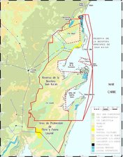 Sian Ka'an Reserve Map. (Source: NOAA Marine Protected Area Management Effectiveness Initiative)
 Olmsted et al. describe the following vegetation types: medium altitude semi-evergreen forest; medium and low altitude semi-deciduous forest; low altitude flood forest; tasistal (or palm savanna) formation; freshwater and saltwater marshes; petenes (or hammocks); dwarfed mangroves; fringing mangroves; and dunes and keys. A total of 859 vascular plant, 15 pteridophyte, 21 bryophyte and 159 algal species have been recorded.
Medium altitude semi-evergreen forest, covering about 108,500 ha, represents the climax vegetation in non-flooded areas, although it is scarce in accessible parts due to disturbance. Some 120 trees and shrubs are listed in Olmsted et al., including larger trees such as Manilkara zapota, Bursera simaruba and Lysiloma latisiliquum, and in some areas Brosinum alicastrum and Mastichodendron foetidissimum. Palm Thrinax radiata, Nectandra coriacea, N. salicifolia, Byrsonima bucidaefolia, Coccoloba sp. and Caesalpinia gaumeri are the most abundant plants. Some 100 tree and shrub species have been identified in medium and low semi-deciduous forest, which extends over 11,700 ha, the main species being Bursera simaruba, Lysiloma latisiliquum, Manilkara zapota, Metopium brownei, Piscidia piscipula and Psidium sartorianum. The abundance of Beaucarnea ameliae and palm Pseudophoenix sargentii (R) is a characteristic feature of this forest type. The height of dominant tree species in the medium forest can reach 14 m but is generally between 10 m and 12 m, while only ranging from two to 9 m in low forest. Flood forest is subdivided into low forest with closed and open canopy tree communities, the latter being found in lower, wetter areas. Dominant species in the tree community are Haematoxylum campechianum, Bucida spinosa and Dalbergia glabra, with others including Byrsonima bucidaefolia, Cameraria latifolia, Erythroxylon areolatum and Malpighia lundellii. Acoelorraphe wrightii and Crescentia cujeteare frequently found in more flooded areas. Aggregations of tasiste Acoelorrhaphe wrightii (flooded palm) are found scattered in slightly higher areas which are frequently flooded, in grass marshlands or amongst dry and flooded forests. It can form monospecific 'islands' on patches of dark soil but is often found in association with Acrostichum danaeafolium, Bucida spinosa, Cladium jamaicense, Conocarpus erectus, Dalbergia glabra, Chrysobalanus icaco and Thrinax radiata.
Grass communities cover large areas to the south and north and occur among mangroves and inland forests (though not in areas of high salinity). This vegetation type occurs as a mosaic with three intermingled associations dominated by Cladium jamaicense, Schoenus nigricans, and Eleocharis cellulosa respectively. Other species found with these communities are Cassytha filiformis, Ipomoea sagittata, Pluchea purpurascens, Crinum americanum, Fuirena breviseta, Dichromena ciliata, Eleocharis caribaea (E), Bletia purpurea, Agalinis sp. and Dichanthelium dichotomum. Petenes or hammocks, emerge from the flooded marshes, covering areas from several tens of meters in diameter to more than one kilometer. Larger petenes may have a central waterbody. These islands are vegetated by aggregations of Cladium spp., Phragmites australis, Bucida spp., Crescentia and Haemotoxylum spp., and trees Metopium spp., Ficus spp. and Plumeria spp., and palms Thrinax spp. and Sabal spp.. There are extensive areas covered by scattered dwarf mangroves to the east of the freshwater marshes. Plants cover 35-40% of the substrate, with Rhizophora mangle (which may reach up to 2 m in height) occupying much of this. Main arboreal components of the fringing mangroves, in order of resistance to salinity are Rhizophora mangle, Avicennia germinans and Laguncularia racemosa. In drier parts, Conocarpus erectus, Manilkara zapota and Thrinax radiata are also present. Non-tree species comprise mangrove fern Acrostichum daneaefolium and the climber Rhabdadenia biflora.
Coastal dunes stretch along 64 km of the coast, from the northern limit of the reserve to Punta Allen and from Punta Hualastoc to Punta Tupac. As Sian Ka'an lies so close to the Caribbean islands, there is a strong affinity between their flora. Some endemics are Cordia sebestana, Metopium brownei, Acoelorraphe wrightii, Suriana maritima, Thrinax radiata and Tournefortia guaphalodes.
The introduction and cultivation of coconut Cocos nucifera, has replaced about 60% of the natural vegetation on the coastal dunes. Selective felling has affected mahogany Swietenia macrophylla, red cedar Cedrela odorata, white cedar Simarouba glauca, Cordia dodecandra, Guaiacum sanctum, Metopium brownei and Thrinax radiata. Anthropogenic fires for agricultural clearance have affected at least 14,000 ha, although only 2,000 ha have been used. These areas are mainly found either sides of the main road.
Fauna
Garcia gives a preliminary checklist of the various vertebrate species found in the reserve, and it is possible that all vertebrate species characteristic of the Yucatan region occur. A total of 103 species of mammals have been recorded including five species of cat, jaguar Panthera onca, puma Felis concolor, ocelot F. pardalis, margay F. wiedii (K) and jaguarundi F. yagouaroundi. Other mammals include Central American tapir Tapirus bardii (V), Caribbean manatee Trichechus manatus (V), spider monkey Ateles geoffroyi (V), howler monkey Alouatta villosa, kinkajou Potos flavus, white-tailed deer Odocoileus virginianus, red brocket Mazama americana, peccaries Tayassu pecari and T. tajacu, paca Agouti paca, tayra Eira barbara and collared anteater Tamandua tetradactyla.
Some 339 bird species have been recorded in Sian Ka'an, with about two-thirds breeding inside the reserve. Due to the great diversity of aquatic habitats, marine and wading birds are well represented. Sixteen raptor species are found, as well as frigate bird Fregata magnifiscens, comorant Phalacrocorax spp., roseate spoonbill Ajaiai ajaja, greater flamingo Phoenicopterus ruber and jabiru Jabiru mycteria. Forty-two species of amphibian and reptile have been recorded. These include four of the six turtle species found along Mexico's coast; green turtle Chelonia mydas (E), hawksbill turtle Eretmochelys imbricata (E), loggerhead turtle Caretta caretta (V), and leatherback Dermochelys coriacea (E). Morelet's crocodile Crocodylus moreletii and American crocodile C. acutus (E) also occur. Other species include Ctenosaura similis, Basiliscus vittatus, Thecadactylus rapicaudus, Boa imperator, Crotalus durissus, Bothrops asper, Bufo valliceps, Hyla stauffery, H. microcephala, H. loquas and Leptodactylus melanonotus. Fish are abundant, and over 52 species have been recorded. A total of 550 terrestrial and 843 aquatic invertebrate species have been observed.
Cultural Heritage
Twenty-three Mayan sites have been recorded in the reserve, while the Chunyaxché ruins, Vigia del Lago and Xamach, are just to the north. Recently, a 24 km-long Mayan artificial canal was discovered.
Local Human Population
The reserve is located in the least developed part of Quintana Roo, and the population is predominantly of Mayan origin. There are reported to be some 800 inhabitants living within the reserve. About 450 people live in the Javier Rojo Gomez settlement on Punta Allen, and a further 50 at Punta Herrero. The rest live in settlements ('rancherias') scattered on the coast and in the forest. Most inhabitants depend on fishing, especially of spiney lobster Panulirus argus, and agriculture, with some 75 ha occupied with maize fields, 1,352ha with livestock and 760 ha with copra. Approximately 200 plant species are used by the Maya people. There are three manned lighthouses within the reserve.
Visitors and Visitor Facilities
Tourism began to develop around the 1970s, when the Tulum beaches to the north started to attract foreign visitors. Despite the lack of basic services (electricity and drinking water), visitor facilities in the form of trailer parks and rustic huts have extended southwards along the coastal strip. In 1983, use of the area by tourists still appeared to be low. In the north, there is a small hotel (Hotel Pez Maya), Boca Paila fishing club, and three areas for trailers and 'cabins', while elsewhere within the reserve there is only a small hotel and cabin area at Punta Pajaros.
Scientific Research and Facilities
Research in the area is coordinated by the Centro de Investigaciones de Quintana Roo (CIQRO), and extensive surveys have been carried out on different aspects of the wildlife, ecology, geology and hydrology. A team from the University of Mexico is currently evaluating the marine resources. In addition, various research institutions carry out research in the reserve. Lodging is available for visiting scientists. To date there have been few meteorological records from the reserve itself, but two climatological stations have now been donated by the National Meteorological Service (SARH). El Ramonal experimental plot has been used to develop agricultural techniques that preserve the delicate Yucatan soil, using mixed cropping and crop rotation. Studies are also being carried out to ensure the sustainable exploitation of lobster and chit palm tree resources, both integral components of the local economy.
Conservation Value
Sian ka'an preserves several endangered and endemic species, and 40 different sites of pre-hispanic culture.
Conservation Management
In 1993, an agreement was signed between the Federal Government and the World Bank to finance ten Mexican reserves through the Global Environment Facility (GEF) program. As a result, an official management program for Sian ka'an has been prepared. The program is comprehensive, identifying management zones and 16 objectives, including protection, resources management, monitoring (Environmental monitoring and assessment), environmental restoration, archaeological and cultural protection and management, social development, public use (tourism), and infrastructure. Achievements to date include control of tree-felling; considerable reduction in commercial hunting and indiscriminate use of forest products (central area); removal of exotic (Exotic species) casarinw trees; establishment of ecological regulations for the relocation of Colonia Punta Herrero, which was considerably damaged by cyclones; and the contracting of local inhabitants from Chunyaxché as reserve workers, and their collaboration in captive breeding projects.
A private foundation, Amigos de Sian Ka'an, comprising dedicated local people, is carrying out studies funded by WWF, The Nature Conservancy and others. In March 1989, a rural training program, part of the Amigos de Sian Ka'an's Regional Development Project, was initiated. A Public Information Project promotes the reserve through the media. A revised management plan was completed in late 1995.
Management Constraints
Of particular concern is the development of tourist facilities in the north of the reserve. The seemingly uncontrolled urban growth along the coast, with inadequate sewage systems which discharge directly into the sea, seriously threatens surrounding reef life. Most tourist activities are planned for the area between Cancun and Tulum. Should these plans proceed, the coastline will be profoundly modified. Recent forest fires have also occurred in this same area, affecting 135,000 ha, which, together with the regular occurrence of cyclones, emphasize the fragility of this ecosystem.
At present, there is a 68 km long coastal belt which is mainly planted with copra, and has 25 small farms ('ranchos'). During the last ten years, 95% of coconut palms have been destroyed by a "lethal yellowing" disease, and farmers are now introducing a new, more resistant variety of palm. Forest exploitation is limited to the collection of useful wild plants and hunting for subsistence, although there is some commercial and sport hunting which should be regulated. Valuable timber species such as mahogany, cedar, 'siricote' and 'guayacan' are being exhausted through over-exploitation. Chit palm is in much demand and is used in the construction of lobster traps. There may also be some impact from fishing, but the extent of this is unclear (although it is apparent that some lobster poaching continues). The surrounding communities are increasingly abandoning traditional ways in favor of more commercial practices that in time may threaten the reserve. There are five unpaved roads in the reserve, whose margins are becoming increasingly disturbed.
Inaccessibility provides a certain degree of protection, but at the same time hinders monitoring (Environmental monitoring and assessment), research, administration and active protection. In addition, there are only ten park rangers to patrol this huge area. Reserve boundaries are not easily defined due to the existence of peripheral "ejidos", and thus their protection is difficult. Due to the high humidity, the cost of building and equipment maintenance is high. This is not helped by the high incidence of cyclones. Soil erosion is increasing in deforested areas. Potential pollution from Felipe Carrillo and Andres Quintana Roo ejidos exists, as these towns are within the hydrographic basin of the reserve and their effluent (domestic and industrial/agricultural (Agricultural pesticide contamination)) may penetrate the water table through absorption by calcareous soils. Water use should be controlled as excessive use could lead to increased salinity. Environmental legislation has recently been reviewed, but it still remains to be adequately enforced.
Staff
A director with a staff of 21.
Budget
Variable. In 1995, government support came from the GEF program. Other financial support from CONABIO Mexico, TNC, WWF-US is directed towards research and restoration programs through NGOs and research centers.
IUCN Management Category
- II (National Park)
- Biosphere Reserve
- Natural World Heritage Site - Criteria iii, iv
Further Reading
- Anon. (1987). Plan de Manejo de La Reserva de la Biosfera Sian Ka'an. Direccion General de Conservación Ecológica de los Recursos Naturales. 141 pp.
- Anon. (1993). Programa de manejo de la Reserve de la Biosfera de Sian ka'an. Instituto Nacional de Ecologia Secretaria de Desarrollo Social. 97 pp.
- Anon. (n.d.a). Mesa sobre problemas ecológicos. Foro de Cultura Caribeña. 2° Festival Internacional de Cultura del Caribe. 8 pp.
- Anon. (n.d.b). Resultados de la primera evaluación académica de la Reserva de la Biosfera Sian Ka'an. 4 pp.
- Aviña, C.R. (1983). La cacería. In: Sian ka'an. Estudios preliminares de una zona en
- Quintana Roo propuesta como Reserva de la Biosfera. Centro de Investigaciones de Quintana Roo, A.C., Puerto Morelos.
- Briones-Fourzan and Phillips, B.F. (1991). Fishery characteristics, growth and movement of the spiny lobster Panulirus arqus in Bahia de la Ascension, Mexico. Fish Bull 89(1).ISBN: 0852382642
- CIQRO (1983). Sian Ka'an: Estudios Preliminares de una zona en Quintana Roo propuesta como Reserva de la Biosfera Centro de Investigaciones de Quintana Roo, A.C., Puerto Morelos.
- Consejo, J.J., Garrido, D. and Lopez, A. (1987). La reserva de la Biosfera Sian Ka'an. Flora, Fauna y Areas Silvestres (3): 15-20.
- Espejel, I. (1983). Vegetacion de la dunas costeras de la Peneinsula de Yucatan 1. Reserva de la Biosfera de Sian ka'an. Quintana Roo, Mexico. Biotica 9(2):183-210.
- Espejel, I. (1986). Coastal dune vegetation of the Yucatan Peninsula II. The Nature Reserve Sian ka'an Quintana Roo Mexico. Biotica 11(1): 7-24.
- Garcia, S.M. (1983). Fauna Silvestre. In: Sian ka'an. Estudios preliminares de una zona en Quintana Roo propuesta como Reserva de la Biosfera. Centro de Investigaciones de Quintana Roo, A.C., Puerto Morelos.
- Lazcano-Barrero, M. A. (1990). Conservacion de Cocodrilos en Sian ka'an. Boletin Amigos de Sian ka'an 6:8-10.
- Lopez, J., Keyes, M., González-Romero, A., Cabrera, E. and Sánchez, O. (1989). Estimación preliminar acerca del efecto de los incendios de 1989 sobre las comunidades naturales de Quintana Roo. 9 pp.
- Lopez, A., (1983). Mapa de vegetacion y uso del suelo. 1:80,000. In: Sian ka'an. Estudios preliminares de una zona en Quintana Roo propuesta como Reserva de la Biosfera. Centro de Investigaciones de Quintana Roo, A.C., Puerto Morelos.
- Lopez, A. (1990). Avifauna de la reserve de la biosfera de Sian ka'an. In: Navarro, D. and Robinson, J.G. (eds). Diversidad Biologica en la Biosfera de Sian ka'an Quintana Roo, Mexico. Centro de Investigaciones de Quintana Roo and the University of Florida. Pp 331-370.
- Lopez, A. and Ramo, C. (1992). Colonial waterbird populations in the Sian ka'an biosphere reserve (Quintana Roo, Mexico). Wilson Bulletin 104:501-515.
- Navarro, D., Jimenez, A., Juarez, J. (1990). Los mamiferos de Quintana Roo. In: Navarro, D. and Robinson, J.G. (eds). Diversidad Biologica en la Biosfera de Sian ka'an Quintana Roo, Mexico. Centro de Investigaciones de Quintana Roo and the University of Florida. Pp 371-450.
- Olmsted, I., Lopez, A. and Duran, R. (1990). La vegetacion de Sian ka'an. In: Navarro, D. and Robinson, J.G. (eds). Diversidad Biologica en la Biosfera de Sian ka'an Quintana Roo, Mexico. Centro de Investigaciones de Quintana Roo and the University of Florida. Pp 47-94.
- Rangel, J., Enriquez, P. and Guzman, J. (1993). Colonias de reproduccion de aves costeras en Sian ka'an. In: Salazar, S.I. and Gonzalez, N.E. (eds). Biodiversidade Marina y costera de Mexico. Centro de Investigaciones de Quintana Roo. Pp 833-840.
- Rosado-May, F.J. (1994). The Sian ka'an Biosphere Reserve project. In: Meffe, G.K. and Carroll, C.R. (Eds). Principles of Conservation Biology. Sinauer Associates. Sunderland, Massachesetts, USA. 600 pp.
- Sheearn-Stone, O. (1989). Sian Ka'an - where the sky is born. WWF Reports December 1989/January 1990. Pp. 10-12.
- Villanueva, R. and Cabrera, E. (1988). Addendum to the floristic list of the Sian ka'an Biosphere Reserve Mexico. Biotica 13(1-2): 141-146.
| Disclaimer: This article is taken wholly from, or contains information that was originally published by, the United Nations Environment Programme-World Conservation Monitoring Centre (UNEP-WCMC). Topic editors and authors for the Encyclopedia of Earth may have edited its content or added new information. The use of information from the United Nations Environment Programme-World Conservation Monitoring Centre (UNEP-WCMC) should not be construed as support for or endorsement by that organization for any new information added by EoE personnel, or for any editing of the original content. |