Saharan halophytics
Scattered across the Sahara, "Sebkhas" or "Chotts" are saline depressions in the desert that remain predominantly dry. Although flooding is rare, some of these areas flood annually. They are important habitats for small rodents and are important for grazing camels during dry seasons. The habitats of this ecoregion are not particularly threatened, as human populations are very small and most of the areas are too saline to be used for farming. Large mammals, however, have been hunted out from these areas. Woody resources, where available, are used by desert people. The only permanently populated part of the ecoregion is the Siwa Oasis in Egypt, which has permanent freshwater sources from large springs.
Location and General Description
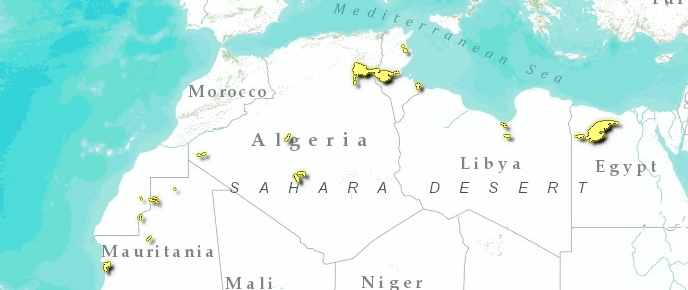
This ecoregion is restricted to some suitable semi-desert and desert locations in the northern portion of Africa, in Morocco, Algeria, Tunisia, Libya, Egypt, Western Sahara and Mauritania. The most extensive of the areas are Chott Melghir, Oued Rir Vally, Hodna, Sebkhat Tidikelet, Sebkha of Timimoun, Tefedest, Chott El Djerid and the Qattara Depression and Siwa Depression in Egypt.
The vegetation of the ecoregion is a part of the Azonal ‘halophytic vegetation’ mapped by White. In the large Djerid Basin, the central portion is covered by stands of Halocnemum strobilaceum (the most adapted phanerogam species) and then followed by vegetation belts of Salsola tetrandra, Suaeda mollis and Suaeda fruticosa. Further out there is a belt of Salsola vermiculata, Traganum nudatum and Atriplex halimus, which indicates that the soil is less salty and might be cultivated. Many species of Atriplex can also be found in the more humid habitats, together with species of Traganum (T. boveana, T. balansae, T. pauciovulata), while the less saline flat playa areas are covered by Limoniastrum guyonianum.
In Egypt the Qattara Depression is 285 kilometers (km) long and 135 km wide, about 19,500 km2 of land below sea level with a maximum depth of 133 meters (m). There are saline marshes under the northwestern and northern escarpment edges, and extensive playas that flood occasionally. Moghra oasis, the one oasis in the depression, is uninhabited and has a 4 km2 brackish lake, including Phragmites swamp. Salt marshes also occur and occupy approximately 300 km2, although in some areas, wind blown sands are encroaching. About one-quarter (26 percent) of the 19,500 km2 area is occupied by playas, which are comprised of hard crust and sticky mud, and which are occasionally filled with water.
The Siwa Depression in Egypt is much smaller; it extends in an east-west direction with a length of 80 km and maximum breadth of 26 km. At its maximum depth it is about 25 m below sea level. It is 82 km long and has a maximum width of 28 km, but narrows in places to 2 km. There are approximately 18 lakes in the depression. Each are surrounded by salt and brackish marshlands, which are the remains of once larger lakes. The paleocoastline of these ancient lakes can be seen 8-12 m below sea level. The present lakes cover approximately 7 km2 as well as another 10 km2 of marshland consisting of Phragmites and Typha swamp. The lakes may dry up in the summer, or shrink considerably. All of the lakes are saline, but are supplied with freshwater from 18 underground springs. These springs supply water that is believed to have been underground for 30,000 to 50,000 years. Only Chara and other algae, as well as a couple of species of fish, are able to survive in the brackish waters of the lakes.
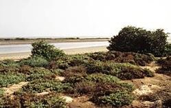
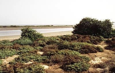
 Banc d'Arguin NP, Mauritania (Photograph by © WWF-Canon/John E. Newby)
 With the exception of the areas outlined above, most of the wetlands in the ecoregion are highly seasonal (or even ephemeral) playas with salty crusts and shifting sands. Gradients of salinity and sand tenure influence the vegetation distribution in these areas.
The reduced wetlands of northern Africa are a recent feature in geological time. There is evidence that much larger areas of the Sahara had adequate water up to 5-6000 years ago, and major drying periods often coincided with glacial periods. There have been several periods of arid and moist climates in the area over the past 20,000 years, with the wetter periods greatly shrinking the Sahara Desert, resulting in lakes and permanent rivers. The component parts of this ecoregion are remnants of the largest of these wetland areas in northern Africa, which have not yet wholly dried up. During these wetter periods, the ecoregion was inhabited by a large mammal fauna that included elephant (Loxodonta africana), hippopotamus (Hippopotamus amphibius) and various species of antelopes and their predators. Human hunters and fishermen also resided in the area at that time. Currently the ecoregion is in a ‘hyper arid’ phase, with high summer temperatures, low winter temperatures and rainfall between 10 and 100 millimeters (mm) per annum. In some years there is no rain at all. The temperature can reach over 50° Celcius (C) in the summer and fall to below 0°C during the winter.
The [[soil]s] of the ecoregion are mainly Solonchaks, which have a high salt content. This ecoregion was once comprised of larger lakes that have since dried up over the past few thousand years as the climate has become drier. This desiccation is the cause of the playa landscapes and the brackish to hypersaline waters that are found in some areas.
The human population of the Qattara and Siwa Depressions is small. Siwa has a permanent town containing a few hundred residents, which has been settled for thousands of years. There are no permanent settlements in the Qattara Depression. In the other areas there are no settlements, with the human population very low to absent.
Biodiversity Features
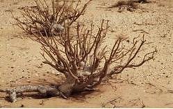
 Desert shrub (Euphorbia balsamifera), near Teichott in Banc d' Arguin National Park, Mauritania (Photograph by © WWF-Canon/Meg Gawler)
 The mammalian, amphibian and reptilian faunas of these habitats comprise a small number of species that contain a mix of Palearctic and Afrotropical affinities. Among the small mammals, gerbils (e.g. Gerbillus campestris and G. nanus) are the most abundant species. There are also a number of other small mammal species. These include fat sand rats (Psammomys obesus and Psammomys vexillaris), which are adapted to feed on the leaves and stems of salty succulents, as well as other desert-adapted species such as Meriones shawi, M. crassus, Jaculus jaculus, J. orientalis, Massoutiera mzabi, Ctenodactylus vali, C. gundi, and Pachyuromys duprasi. One predator in the ecoregion is Vulpes zerda. In the past, addax (Addax nasomaculatus, CR) would probably have occurred in this ecoregion, but it is likely to have been extirpated. Small numbers of scimiter-horned oryx (Oryx dammah, EX) may have also occurred. Other desert antelopes may still be found in small numbers, such as slender-horned gazelle (Gazella leptoceros, EN), Dama gazelle (Gazella dama, EN) and the red-fronted gazelle (Gazella rufifrons, VU).
The reptile diversity is relatively high in and around this ecoregion, including the rare Coluber algirus. There are also a number of desert-adapted birds that are found in the area, such as thick-billed lark (Ramphocoris clotbey), desert wheatear (Oenanthe deserti) and red-rumped wheatear (Oenanthe moesta). In the wetland areas, especially when flooded, a greater diversity of birds can be found. In the Siwa Depression this includes the lesser flamingo (Phoeniconaias minor). It is possible that the globally threatened slender-billed curlew (Numenius tenuirostris, CR) uses some of the ephemeral wetlands in this ecoregion, as this species is also found during the winter months in a few North African coastal wetlands.
Current Status
Very little is known about the conservation status of most of the areas within this ecoregion. An exception would be the Siwa Oasis, which is relatively well known and visited around the edge of the lakes. In general, it is believed that the drier and less frequently inundated saline depressions inland of the main human population centers are largely untouched by man. It is also believed that parts of the ecoregion that support permanent water sources (e.g. Siwa) have been modified, although they still retain much of the original habitat and species (except for the larger mammals) which would have previously occurred in the area. There are no protected areas in the ecoregion.
Types and Severity of Threats
The main threats to these habitats are not well known. Nevertheless, overgrazing in the dry season by camels used for transport by desert people is believed to be a threat to some areas. Moreover, there is a proposed project to flood the Qattara Depression with seawater to make an inland sea that would destroy the natural habitats and replace them with a large salt lake. An additional threat is the continued natural drying of the area (perhaps induced by global warming), which might result in the complete loss of wetland habitats and their replacement with salt flats and sand areas similar to those seen widely in the Sahara Desert.
Justification of Ecoregion Delineation
The linework for this ecoregion is taken directly from the ‘halophytic vegetation’ unit of White. Although White does not separate the northern African from the southern African halophytic areas, experts felt that the geographic distance between and the significant differences in the floristic and faunistic composition were sufficient to justify separating the areas into separate ecoregions.
Additional information on this ecoregion
- For a shorter summary of this entry, see the WWF WildWorld profile of this ecoregion.
- To see the species that live in this ecoregion, including images and threat levels, see the WWF Wildfinder description of this ecoregion.
- World Wildlife Fund Homepage
Further Reading
- Climap 1976. The surface of the ice age earth. Science 191: 1131-1144.
- Guinochet, M. 1951. Contribution à l’étude phytosociologique du Sud-Tunisien. Pages 131-153 in Bulletin de la Société d’Histoire Naturelle d’Afrique du Nord. Tome 42.
- Hilton-Taylor, C. 2000. The IUCN red list of threatened species. Gland, Switzerland and Cambridge, U.K. ISBN: 2831705657
- Hughes, R.H. and J.S. Hughes, 1992. A directory of African wetlands. IUCN, Gland, Switzerland and Cambridge, UK. ISBN: 2880329493
- Lay, D.M. 1991. Implications of climatic change for the distribution and evolution of mammals in the Sahara-Gobian desert complex. Pages 136-146 in J.A. McNeely and V.M. Neronov, editors. Mammals in the Palaearctic Desert: status and trends in the Sahara-Gobian region. The Russian Acedemy of Sciences, and the Russian Committee for the UNESCO programme on Man and the Biosphere (MAB).
- Le Houérou, H.N. 1991. Outline of a Biological History of the Sahara. Pages146-174 in J.A. McNeely and V.M. Neronov, editors. Mammals in the Palaearctic Desert: status and trends in the Sahara-Gobian region. The Russian Acedemy of Sciences, and the Russian Committee for the UNESCO programme on Man and the Biosphere (MAB).
- Nicholson, S.E. and H. Flohn. 1980. African environmental and climatic changes and the general atmospheric circulation in the Late Pleistocene and Holocene. Climatic Change 2: 313-348.
- Ozenda, P. 1983. Flore du Sahara. Pages 21-32. Editions du Centre National de la Recherche Scientifique (CNRS), Paris.
- Petit-Marie, N., G. Delibrias and C. Gaven. 1980. Pleistocene lakes in the Shati area, Fezzan (2730’N). Paleoecology of Africa 12: 289-295.
- Van Zinderen Bakker, Dr. E.M. 1979. Quaternary paleoenvironments of the Sahara region. Paleoecology of Africa 11: 83-104.
- White, F. 1983. The vegetation of Africa, a descriptive memoir to accompany the UNESCO/AETFAT/UNSO Vegetation Map of Africa (3 Plates, Northwestern Africa, Northeastern Africa, and Southern Africa, 1:5,000,000). UNESCO, Paris.
- Zahoran, M.A. and A.J. Willis. 1992. The vegetation of Egypt. Chapman and Hall, London.
| Disclaimer: This article is taken wholly from, or contains information that was originally published by, the World Wildlife Fund. Topic editors and authors for the Encyclopedia of Earth may have edited its content or added new information. The use of information from the World Wildlife Fund should not be construed as support for or endorsement by that organization for any new information added by EoE personnel, or for any editing of the original content. |

