Plymouth, England (Biology)
Contents
Plymouth, England
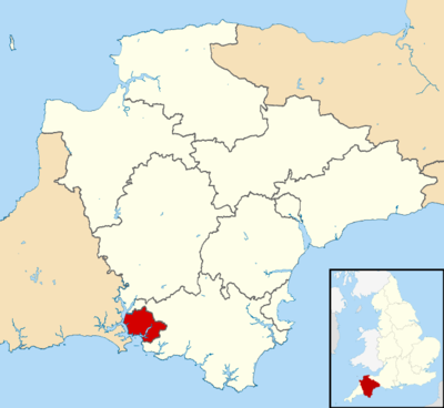
Plymouth, England is a city of about 257,000 people on the south coast of England, approximately 190 miles (310 km) southwest of London.
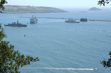
The city developed where Tamar River and the smaller River Plym flow into Plymouth Sound. The sound and the rivers provide a significant natural harbor fronting on to the English Channel, near the Atlantic Ocean.
Since 1967, the City of Plymouth has included the suburbs of Plympton and Plymstock, which are on the east side of the River Plym.
Plymouth's history goes back to the Bronze Age. The earliest settlement grew at Mount Batten on the west side of the Sound at the mouth of the River Plym. This settlement continued to grow as a trading post for the Roman Empire, until the more prosperous village of Sutton, the current Plymouth, surpassed it.
On September 6, 1620, the ship Mayflower, departed Plymouth with 102 passengers. These colonists, now known as the Pilgrims, established Plymouth Colony, the second permanent English settlement in United States of America, in the southeastern portion of the modern state of Massachusetts. Subsequently these Pilgrims, along with local Native American tribes, celebrated one of the first Thanksgiving holidays in the New World.
During the English Civil War the town was held by the Parliamentarians and was besieged between 1642 and 1646.
Throughout the Industrial Revolution Plymouth grew as a major shipping port, handling imports and passengers from the Americas, while the neighbouring town of Devonport grew as an important Royal Naval shipbuilding and dockyard town.
The county boroughs of Plymouth and Devonport, and the urban district of East Stonehouse were merged in 1914 to form the single county borough of Plymouth – collectively referred to as The Three Towns.
The city's naval importance later led to its targeting and partial destruction during World War II, an act known as the Plymouth Blitz. After the war, the city centre was completely rebuilt.
Today the city is home to around 257,000 people, making it the 19th most populous city in England.
Plymouthis governed locally by Plymouth City Council and is represented nationally by three MPs.
Plymouth's economy is still strongly influenced by shipbuilding, but has become a more service-based economy since the 1990s.
It has the 9th largest university in the United Kingdom by number of students, the University of Plymouth.
Plymouth is home to the largest operational naval base in Western Europe – HMNB Devonport. It covers over 650 acres and has 15 dry docks, four miles of waterfront, 25 tidal berths and 5 basins.
Plymouth has ferry links to France and Spain and an airport with European services.
Geography
Plymouth has its origins in the physical geography of it location, the River Plym to the east and the River Tamar to the west; both rivers flow into the natural harbour of Plymouth Sound; a significant natural harbor fronting on to the English Channel, near the Atlantic Ocean.
The valleys were deeply cut by their rivers and subsequently drowned or inundated by the sea at the end of the last ice age. As a result the coastline reaches inland along these deep river valleys producing excellent deep-water anchorages but also cutting the coastline into many small peninsulas, which impede communications by land. Originally these creeks stretched far inland and could only be crossed by fords or bridges high upstream of the muddy inlets. The silting up or deliberate in filling of many of these creeks in later years has hidden the impact that the physical geography exerted on the early settlement in this area. (The early history of Plymouth, Plymouth City Council)
The River Tamar forms the boundary between the counties of Devonshire and Cornwall. The estuary of the Tamar is known as the Hamoaze on which is sited Devonport Dockyard.
The River Plym, which flows off Dartmoor to the north-east, forms a smaller estuary to the east of the city called Cattewater.
Plymouth Sound itself is, naturally, a open bay with a rocky coastline where it has not been modified by settlement.
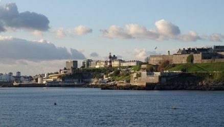
A sizable south facing open public space on the edge of Plymouth Sound is known as Plymouth Hoe or simply the Hoe from Anglo-Saxon word for a sloping ridge shaped like an inverted foot and heel.
The western and northern sides of the old harbour area of Plymouth, regarded as being roughly equivalent to the location and size of the medieval town of Sutton, is known as the Barbican, after the name for a fortified gate, which likely existed in the wall of the medieval town.
Plymouth Sound is protected from the sea by the Plymouth Breakwater, in use since 1814.
Geologically, the bulk of the city is built upon Upper Devonian slates and shales and the headlands at the entrance to Plymouth Sound are formed of Lower Devonian slates, which can withstand the power of the sea. A band of Middle Devonian limestone runs west to east from Cremyll to Plymstock including the Hoe. To the north and north east of the city is the granite mass of Dartmoor.
The Unitary Authority of Plymouth is 30.8 square miles (80 km2), but the city of Plymouth, as cited from Plymouth City Council, is 30.61 square miles (79.3 km2). The topography rises from sea level to a height, at Roborough, of about 509 feet (155 m) above Ordnance Datum (AOD).
Climate
Along with the rest of Southwest England, Plymouth has a temperate oceanic climate (Koppen Cfb) which is generally wetter and milder than the rest of England. This means a wide range of exotic plants can be grown. The annual mean temperature is approximately 11 °C (52 °F). Due to the modifying effect of the sea the seasonal range is less than in most other parts of the UK. February is the coldest month with mean minimum temperatures between 3 °C (37 °F) and 4 °C (39 °F). Snow is rare, not usually equating to more than a few flakes, but there have been exclusions, namely the European winter storms of 2009-10 which, in early January, covered Plymouth in at least 1 inch (2.5 cm) of snow; more on higher ground. Another period of notable snow occurred from 17–19 December 2010 when up to 8 inch (20 cm) of snow fell through the period – though only 2 inches (5 cm) would lie at any one time due to melt. Over the 1961-1990 period, annual snowfall accumulation averaged less than 7 cm (3 in) per year. July and August are the warmest months with mean daily maxima over 19 °C (66 °F).
Southwest England has a favoured location when the Azores High pressure area extends north-eastwards towards the UK, particularly in summer. Coastal areas have average annual sunshine totals over 1,600 hours.
Rainfall tends to be associated with Atlantic depressions or with convection. The Atlantic depressions are more vigorous in autumn and winter and most of the rain which falls in those seasons in the south-west is from this source. Average annual rainfall is around 980 millimetres (39 in). November to March have the highest mean wind speeds, with June to August having the lightest winds. The predominant wind direction is from the south-west.
Typically, the warmest day of the year (1971–2000) will achieve a temperature of 26.6 °C (80 °F), although in June 1976 the temperature reached 31.6 °C (89 °F), the site record. On average, 4.25 days of the year will report a maximum temperature of 25.1 °C (77 °F) or above. During the winter half of the year, the coldest night will typically fall to −4.1 °C (25 °F) although in January 1979 the temperature fell to −8.8 °C (16 °F). Typically, 18.6 nights of the year will register an air frost.
History
Upper Palaeolithic deposits, including bones of Homo sapiens, have been found in local caves, and artifacts dating from the Bronze Age to the Middle Iron Age have been found at Mount Batten showing that it was a significant point of trade at that time.
The settlement of Plympton, further up the River Plym than the current Plymouth, was also an early trading port, but the river silted up in the early 11th century and forced the mariners and merchants to settle at the current day Barbican near the river mouth. This new community, is recorded in the Domesday Book (1086) as Sudtone, Saxon for south farm. In time, Sudtone became Sutton Harbour, the core of medieval Plymouth. The name Plymouth, meaning mouth of the River Plym, was first mentioned in a Pipe Roll (a financial record maintained by the English Exchequer, or Treasury) of 1211.
Counties at this time were subdivided into regions known as hundreds" From Saxon times, plynouth and is predecessors were in the hundred of Roborough. In 1254 the community gained status as a town in a Royal Charter. Later, in 1439, it was granted a Charter by Parliament.
During the Hundred Years War (1337 - 1453), Plymouth was attacked twice; 1340 and 1403. A series of fortifications were built in the Tudor and Elizabethan eras, which include the four round towers featured on the city coat of arms; the remains of two of these can still be found at Mount Batten and at Sutton Pool below the Royal Citadel.
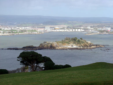
During the 16th century locally produced wool was the major export commodity. Plymouth was the home port for successful maritime traders, among them Sir John Hawkins (1532 - 95), who led England's first foray into the Atlantic slave trade. The Elizabethan navigator, Sir Francis Drake (1540– 96) was born in the nearby town of Tavistock and was the mayor of Plymouth. He was the first Englishman to circumnavigate the world and was known by the Spanish as El Draco meaning The Dragon after he raided many of their ships. According to legend, Drake insisted on completing his game of bowls on the Plymouth Hoe before engaging the Spanish Armada in 1588. A small (6.5 acres) island in Plymouth Sound is named after Drake
On September 6, 1620, the ship Mayflower, departed Plymouth with 102 passengers. These colonists, now known as the Pilgrims, established Plymouth Colony, the second permanent English settlement in United States of America, in the southeastern portion of the modern state of Massachusetts.
During the English Civil War (1642 - 51), Plymouth sided with the Parliamentarians and was besieged for almost four years by the Royalists without success. The civil war ended as a Parliamentary win, but monarchy was restored by King Charles II in 1660, who imprisoned some of the Parliamentary leaders on Drake's Island.
Construction of a fort, the Royal Citadel, began in 1665, at the eastern end of Plymouth Hoe overlooking the Sound.
Throughout the 17th century, Plymouth gradually lost its pre-eminence as a trading port. By the mid-17th century commodities manufactured elsewhere in England cost too much to transport to Plymouth and the city had no means of processing sugar or tobacco imports, although it played a relatively small part in the Atlantic slave trade during the early 18th century.
In 1690 the first major dockyard opened on the banks of the Tamar and further docks were built in 1727, 1762 and 1793. In the 18th century new houses were built near the dock, called Plymouth Dock at the time, and a new town, Devonport, grew up. In 1712 there were 318 men employed and by 1733 it had grown to a population of 3,000 people.
Prior to the latter half of the 18th century grain, timber and then coal were Plymouth's greatest imports. During this time the real source of wealth was from (then a neighbouring town) Devonport – the major employer in the entire region was the dockyard.
The Three Towns conurbation of Plymouth, Stonehouse and Devonport enjoyed some prosperity during the late 18th and early 19th century and were enriched by a series of neo-classical urban developments designed by London architect John Foulston. Foulston was important for the town and was responsible for several grand public buildings, many now destroyed, including the Athenaeum, the Theatre Royal and Royal Hotel, and much of Union Street.
The mile-long Breakwater in Plymouth Sound was designed by John Rennie and work started in 1812; numerous technical difficulties and repeated storm damage meant that it was not completed until 1841, twenty years after Rennie's death. In the 1860s, a ring of Palmerston forts was constructed around the outskirts of Devonport, to protect the dockyard from attack from any direction.
Some of the greatest imports to Plymouth from the Americas and Europe during the latter half of the 19th century included maize, wheat, barley, sugar cane, guano, sodium nitrate and phosphate. Aside from the dockyard in Devonport, industries in Plymouth such as the gasworks, the railways and tramways and a number of small chemical works had begun to develop in the 19th century, continuing into the 20th century.
Between 1439 and 1934, Plymouth had a Mayor. In 1914 the county boroughs of Plymouth and Devonport, and the urban district of East Stonehouse merged to form a single county borough of Plymouth.
During World War I, Plymouth was the port of entry for many troops from around the Empire and also developed as a facility for the manufacture of munitions. Although major units of the Royal Navy moved to the safety of Scapa Flow, Devonport was an important base for escort vessels and repairs. Flying boats operated from Mount Batten. Union Street before World War II shows trams
In 1919 Nancy Astor was elected the first ever female member of parliament to take office in the British Houses of Parliament for the constituency of Plymouth Sutton.
In World War II, Devonport was the headquarters of Western Approaches Command until 1941 and Sunderland flying boats were operated by the Royal Australian Air Force. It was an important embarkation point for US troops for D-Day. The city was heavily bombed by the Luftwaffe, in a series of 59 raids known as the Plymouth Blitz. Although the dockyards were the principal targets, much of the city centre and over 3,700 houses were completely destroyed and more than 1,000 civilians lost their lives. Charles Church, hit by incendiary bombs and partially destroyed in 1941, has not been demolished, as it is now an permanent monument to the bombing of Plymouth during World War II.
On 27 April 1944 Sir Patrick Abercrombie's Plan for Plymouth to rebuild the city was published; it called for the demolition of the few remaining pre-War buildings in the city centre and their replacement with wide, modern boulevards aligned east–west linked by a north–south avenue (Armada Way) connecting the railway station and Plymouth Hoe. Prefabs had started to be built by 1946, and over 1,000 permanent council houses were built each year from 1951–57. By 1964 over 20,000 new homes had been built, more than 13,500 of them permanent council homes and 853 built by the Admiralty. Plymouth is home to 28 parks with an average size of 45,638 square metres (491,240 sq ft). Its largest park is Central Park, with other sizeable green spaces including Victoria Park, Freedom Fields Park, Alexandra Park, Devonport Park and the Hoe.
Postwar, Devonport Dockyard was kept busy refitting aircraft carriers such as the Ark Royal. By the time this work ended in the late 1970s the nuclear submarine base was operational. The army had substantially left the city by 1971, with barracks pulled down in the 1960s, however the city has become home to the 42 Commando of the Royal Marines.
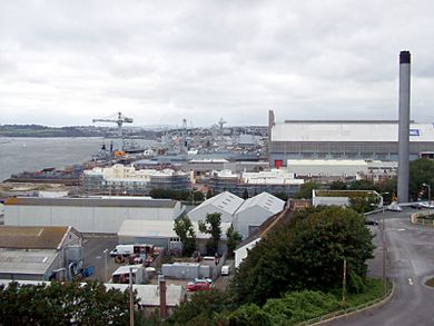 HMNB Dockyard, Devonport. Source: Denna Jones HMNB Dockyard, Devonport. Source: Denna Jones
|
Demography
The first reliable data for Plymouth's population are from the 1801 census.
Earlier estimates are:
- Earth 16th Century - approximately 3,500
- 1588 (year of Spanish Armada) -- approximately 5,000
- 1642 (start of English Civil War) -- approximately 7,000
Prior to 1914 when 1914 the county boroughs of Plymouth and Devonport, and the urban district of East Stonehouse were merged into the City of Plymouth census data was collected separately and here is given as a signle figure.
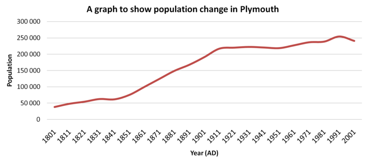 Source: Wikipedia, checked against census figures on PlymouthData.org
The population rose rapidly during the second half of the 19th century, but declined by over 1.6% from 1931 to 1951. In June 2010, the Office for National Statistics estimated that Plymouth's unitary authority area population for mid-2009 was 256,700; 15,980 more people than that of the last census from 2001. The average household size was 2.3 persons. At the time of the 2001 UK census, the ethnic composition of Plymouth's population was 98.4% White, with the largest minority ethnic group being Chinese at 0.3%.
Government
Since 1967, the unitary authority of Plymouth has included the, once independent, towns of Plympton and Plymstock which lie along the east of the River Plym.
In the Parliament of the United Kingdom, Plymouth is represented by the three constituencies of Plymouth Moor View, Plymouth Sutton and Devonport and South West Devon and within the European Parliament as South West England. In the 2010 general election, Sutton and Devonport and South West Devon were held by Conservative MPs Oliver Colvile and Gary Streeter, with Moor View held by Labour MP Alison Seabeck.
Plymouth City Council is formally twinned with:
- Brest, France (1963)
- Gdynia, Poland (1976)
- Novorossiysk, Russia (1990)
- San Sebastián, Spain (1990)
- Plymouth, Massachusetts, United States (2001)
Transport
The A38 dual-carriageway runs from east to west across the north of the city. Heading east, it connects Plymouth to the M5 motorway about 40 miles (64 km) away near Exeter; and heading west it connects Cornwall and Devon via the Tamar Bridge.
A regular international ferry service provided by Brittany Ferries operates from Millbay taking cars and foot passengers directly to France (Roscoff) and Spain (Santander) on the three ferries, MV Armorique, MV Bretagne and MV Pont-Aven. There is a passenger ferry between Stonehouse and the Cornish hamlet of Cremyll, which is believed to have operated continuously since 1204. There is also a pedestrian ferry from the Mayflower Steps to Mount Batten, and an alternative to using the Tamar Bridge via the Torpoint Ferry (vehicle and pedestrian) across the River Tamar.
The city's airport is Plymouth City Airport about 4 miles (6.4 km) north of the city centre. The airport is home to the local airline Air Southwest, which operates flights across Great Britain and Ireland.
Plymouth railway station, which opened in 1877, is managed by First Great Western and also sees trains on the CrossCountry and South West Trains networks. Smaller stations are served by local trains on the Tamar Valley Line and Cornish Main Line.
Education
The University of Plymouth is the 9th largest university in the United Kingdom by total number of students (including the Open University). It has over 30,000 students, almost 3,000 staff. It was founded in 1992 from Polytechnic South West (formerly Plymouth Polytechnic). It has courses in maritime business, marine engineering, marine biology and Earth, ocean and environmental sciences, surf science, shipping and logistics.
The city is also home to three large colleges.
- The University College Plymouth St Mark & St John (known as Marjon or Marjons ), which specialises in teacher training, offers training across the country and abroad.
- The City College Plymouth provides courses from the most basic to Foundation degrees for approximately 26,000 students.
- Plymouth College of Art offers a selection of courses including media. It was started 153 years ago and is now one of only four independent colleges of art and design in the UK.
Plymouth also has 71 state primary phase schools, 13 state secondary schools, eight special schools and three selective state grammar schools, as well as an independent school, Plymouth College.
Plymouth is home to the Marine Biological Association of the United Kingdom (MBA) which conducts research in all areas of the marine sciences. The Plymouth Marine Laboratory is an offshoot of the MBA. Together with the National Marine Aquarium, the Sir Alister Hardy Foundation for Ocean Sciences, Plymouth University's Marine Institute and the Diving Diseases Research Centre, these marine-related organisations form the Plymouth Marine Sciences Partnership. The Plymouth Marine Laboratory, which focuses on global issues of climate change and sustainability. It monitors the effects of ocean acidity on corals and shellfish and reports the results to the UK government. It also cultivates algae that could be used to make biofuels or in the treatment of waste water by using technology such as photo-bioreactors. It works alongside the Boots Group to investigate the use of algae in skin care protects, taking advantage of the chemicals they contain that adapt to protect themselves from the sun.
Services
Since 1973 Plymouth has been supplied water by South West Water. Prior to the 1973 take over it was supplied by Plymouth County Borough Corporation.
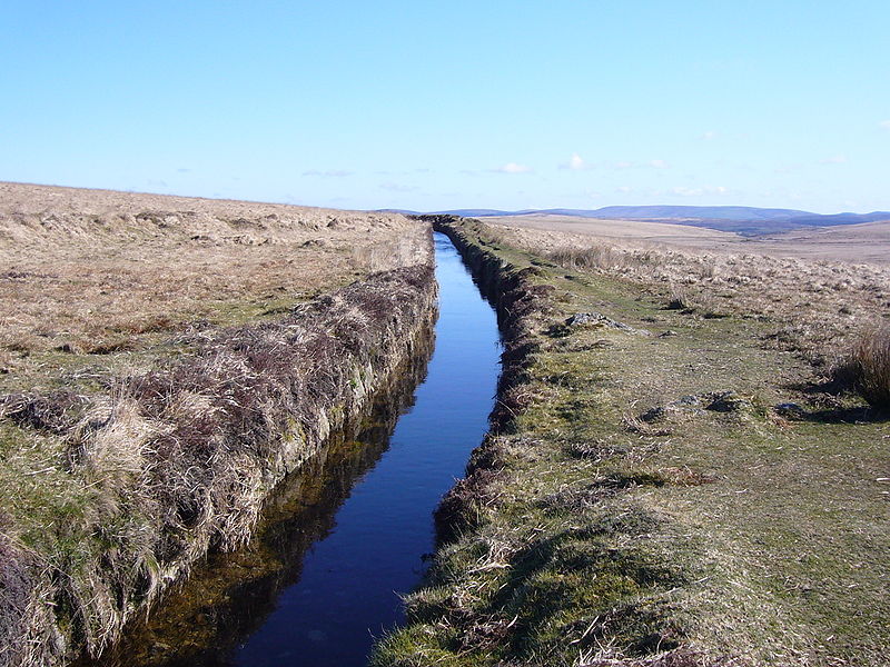
Before the 19th century two watercourses dug into the ground, known as "leats", were built in order to provide drinking water for the town. They carried water from Dartmoor to Plymouth. A watercourse, known as Plymouth or Drake's Leat, was opened on 24 April 1591 to tap the River Meavy. The Devonport Leat was constructed to carry fresh drinking water to the expanding dockyards at Devonport. It was fed by three Dartmoor rivers: The West Dart, Cowsic and Blackabrook. It seems to have been carrying water since 1797, but it was officially completed in 1801. It was originally designed to carry water to Devonport Dockyard, but has since been shortened and now carries water to Burrator Reservoir, which feeds most of the water supply of Plymouth. Burrator Reservoir is located about 5 miles (8.0 km) north of the city and was constructed in 1898 and expanded in 1928.
Plymouth City Council is responsible for waste management throughout the city and South West Water is responsible for sewerage. Plymouth's electricity is supplied from the National Grid and distributed to Plymouth via Western Power Distribution. On the outskirts of Plympton a combined cycle gas-powered station, the Langage Power Station, which started to produce electricity for Plymouth at the end of 2009.
Her Majesty's Courts Service provide a Magistrates' Court and a Combined Crown and County Court in the city. The Plymouth Borough Police, formed in 1836, eventually became part of Devon and Cornwall Constabulary. There are police stations at Charles Cross and Crownhill (the Divisional HQ) and smaller stations at Plympton and Plymstock. The city has one of the Devon and Cornwall Area Crown Prosecution Service Divisional offices. Plymouth has five fire stations located in Camel's Head, Crownhill, Greenbank, Plympton and Plymstock which is part of Devon and Somerset Fire and Rescue Service. The Royal National Lifeboat Institution have an Atlantic 85 class lifeboat and Severn class lifeboat stationed at Millbay Docks.
Plymouth is served by Plymouth Hospitals NHS Trust and the city's NHS hospital is Derriford Hospital 4 miles (6.4 km) north of the city centre and there is also the Royal Eye Infirmary near the city centre. South Western Ambulance Service NHS Foundation Trust operates in Plymouth and the rest of the south west; its headquarters are in Exeter.
References
Geography
- Andrew T. Chamberlain, Keith W. Ray, Charlotte Henderson, Richard Welton Fisher (1994). A Catalogue of Quaternary Fossil-bearing Cave Sites in the Plymouth Area. Plymouth City Archaeology. ISBN1855223457.
- "Devon's rivers: The Tamar . The BBC. 2008-02-06. Accessed November 20, 2011
- Plymouth Sound Shores and Cliffs (PDF). Natural England. Accessed November 20, 2011
- The early history of Plymouth . Plymouth City Council. Accessed November 20, 2011
- Breakwater, Plymouth Data. Acessed November 20, 2011
- Parks and open spaces . Plymouth City Council. Acessed November 20, 2011
- Andrews, Robert (2004). The Rough Guide to Devon & Cornwall. Peter Hack, Kate Hughes, Bea Uhart (2 ed.). Rough Guides. p.139. ISBN9781843533122. Acessed November 20, 2011
- Ordnance Survey. (2005-10-03). Lower Tamar Valley & Plymouth. Ordnance Survey. ISBN0319235270. Acessed November 20, 2011
- The History of Dartmoor Factsheet . Dartmoor National Park Authority. Retrieved 2008-08-31.
Climate
- Climatological Normals of Plymouth, United Kingdom . Climatological Information for United Kingdom and Ireland. The Hong Kong Observatory. Acessed November 20, 2011
- Climatological Normals of Plymouth – 1961–1990. NOAA. Acessed November 20, 2011
- Frost average . Retrieved 2011-06-09.
- Climate Normals 1971–2000 . Meteofrance. Retrieved 9 June 2011.
History
- Brief history of Plymouth . Plymouth City Council. Accessed November 20, 2011
- Plymouth - A History, Plymouth Data. Acessed November 20, 2011
- Devon timeline . Devon County Council. Accessed November 20, 2011
- Cunliffe, Barry (2004). Britain and the Continent:Networks of Interaction . In Malcolm Todd. A Companion to Roman Britain. Blackwell Publishing. p.3. ISBN0631218238. Accessed November 20, 2011
- Eilert Ekwall (1960). The Concise Oxford Dictionary of English Place-names. Oxford University Press, USA; 4th edition. ISBN0198691033.
- Sumption, Jonathan (1999). Sluys and Tournai: The War of the Alberts . The Hundred Years War: Trial by Battle. University of Pennsylvania Press. p.347 ISBN0812216555
- Slave Ships in Plymouth . Plymouth City Council. Acessed November 20, 2011
- Adventurers and Slavers . The National Archives. Acessed November 20, 2011
- Sir Francis Drake . The BBC. Acessed November 20, 2011
- Sir Francis Drake (c.1540 – c.1596) . The BBC. Acessed November 20, 2011
- Kellogg, William O. (2003). American History the Easy Way: The Easy Way (3rd ed.). Hauppauge, N.Y.: Barron's. p.20. ISBN0764119737. cessed November 20, 2011.
- A new life in the New World . The BBC. 2008-02-01. Acessed November 20, 2011
- Point 8a – Mayflower Steps . The BBC. 2008-01-07. Retrieved 2008-07-05.
- Siege . The BBC. 2003-01-06. Acessed November 20, 2011
- Coast Walks: Point 3 – The Citadel . The BBC. 2008-01-25. Acessed November 20, 2011
- Cargo and Trade, Ocean Landing Pier (PDF). Plymouth City Museum and Art Gallery. RAcessed November 20, 2011
- Plymouth, John Foulston . Plymouth Data. Acessed November 20, 2011
- Palmerstons Forts and Batteries , Plymouth Data. Acessed November 20, 2011
- Great War , Plymouth Data. Acessed November 20, 2011
- D-Day in the Plymouth Area Cyber Heritage. Acessed November 20, 2011
- History of Plymouth Pannier Market . Plymouth City Council. Acessed November 20, 2011
- Water Supply to Plymouth Leat . Plymouth Data. Acessed November 20, 2011
- Water supply to plymouth Dock/Devonport . Plymouth Data.Acessed November 20, 2011
- Crownhill Fort, The Landmark Trust
Demography
- Population, Plymouth Data, Accessed November 22, 2011
- A Brief History of Plymouth, Devon, England, Tim Lambert
- Plymouth's Population 2009, Plymouth City Council, from Office of National Statistics, Accessed November 20, 2011
- Area Plymouth (Education Authority): Ethnic Group (KS06) . Office for National Statistics. Accessed November 20, 2011
- Area: Plymouth (Local Authority) - PopulationDensity (UV02) . Census 2001. The Office for National Statistics. Accessed November 20, 2011
- Content of the 2001 census key statistics, Plymouth City Council, from Office of National Statistics, Accessed November 20, 2011
- "NUTS3 GVA (1995–2007) (Excel). Office for National Statistics. December 2009. Retrieved 2010-10-23.
Government
- Department of the Environment (1996-07-18). The Devon (City of Plymouth and Borough of Torbay) (Structural Change) Order 1996. Office of Public Sector Information. ISBN0110627792. Accessed November 20, 2011
- Plymouth and Its Twin Towns . Plymouth City Council. Accessed November 20, 2011
Education
- List of universities by number of students 2008/09 (Excel). The Higher Education Statistics Agency. Accessed November 20, 2011
- University of Plymouth – an introduction . The University of Plymouth. Accessed November 20, 2011
- The History of the University College . The University College Plymouth St Mark & St John. Accessed November 20, 2011
- The College . City College Plymouth. Accessed November 20, 2011
- Plymouth College of Art . Accessed November 20, 2011
- Plymouth Marine Laboratory . Accessed November 20, 2011
- National Marine Aquarium , Accessed November 20, 2011
Other
- Cremyll ferry . Plymouth City Council. Accessed November 20, 2011
- Mount Batten Ferry general info . Mount Batten Ferry website. Retrieved 2008-11-16.
- Torpoint ferry . Plymouth City Council. Accessed November 20, 2011
- Plymouth City Museum and Art Gallery . Plymouth City Council. Accessed November 20, 2011
- Coast Walks: Point 5 – Smeaton's Tower . The BBC. 2008-01-25. Accessed November 20, 2011
- Smeaton's Tower . Plymouth City Council. Accessed November 20, 2011
- Devonport Heritage Trail . DevonportOnline. Accessed November 20, 2011
Further reading
- Dunning, Martin (2001). Around Plymouth. Frith Book.
- Gill, Crispin (1993). Plymouth: A New History. Devon Books.
- Robinson, Chris (2004). Plymouth Then & Now. Plymouth Prints.
- Casley, Nicholas (1997). The Medieval Incorporation of Plymouth and a Survey of the Borough's Bounds. Old Plymouth Society.
- Carew, Richard (1555). The Survey of Cornwall. N.B. Carew refers to Plymouth Hoe as the Hawe at Plymmouth
- Abercrombie, Patrick; James Watson, Laurence Stamp and Gilbert Robinson, (1944-04-27). A Plan for Plymouth. Underhill. N.B. the publication carries the date 1943, which is incorrect according to The Encyclopaedia of Plymouth History
