Physical properties of rivers
Contents
Characteristics of River Flow
 (Source: Biodiversity Institute of Ontario)
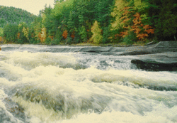
 Lotic systems (rivers and streams) are characterized by continuously flowing waters. These flows are the vitality of the systems and are very dynamic, showing variation on several time scales. Although the traditional focus has been on downstream flow, the lateral movement of water and other materials in a river is also very important (as we shall examine in more detail in the section on floods). Water movement is critical to the distribution of vital nutrients, gases, and small organisms (such as zooplankton). The movements of water and sediments in the river channel are called fluvial processes.
The Current
 (Source: Biodiversity Institute of Ontario)
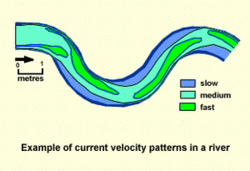
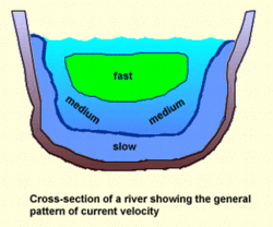
 A river's current is defined as the downstream movement of water. It determines the extent of erosion of the river channel, the degree of particle deposition and the nature of sediments and benthic organisms. The current velocity is complex since the movement of water is not homogenous throughout the channel. This is a result of varying degrees of friction exerted upon the water when it flows across its channel bed, when it carries materials, or between the surface of the water and the atmosphere. The velocity is highest near the middle of the river just below the surface and lowest close to the banks and bottom.
 (Source: Biodiversity Institute of Ontario)
 An increase in volume or depth of a river, or a steepening of its gradient, will result in an increase in its velocity. Velocity can be measured using sophisticated current meters or more simply by timing the movement of a floating object over a given distance (although this method gives only a rough approximation). The current velocity at around six-tenths of the stream depth is considered to be a reasonable approximation of the average river velocity. River flows rarely exceed 6 m/s and are usually less than 3 m/s.
Types of Flow
There are two principal types of flow in lotic systems. Laminar flow is much less common and occurs only in water that is moving very slowly. It is a smooth flow with all the water molecules moving parallel to each other at the same speed and with no mixing between them. Turbulent flow is much more common and arises as the velocity of the water increases. It is characterized by irregular, random motion, which occurs when the water molecules move in different directions and at different velocities from the average of the flow. It is an erratic and mixing progression of water, transferring frictional forces throughout the fluid and redistributing suspended particles. Turbulence explains why streams do not achieve greater velocity down a channel of even gradient, since it counteracts the accelerating forces. Channel roughness also induces turbulence and therefore reduces acceleration. Many small organisms depend on thin layers of laminar flow near the channel bed or over stones to avoid turbulence.
Discharge
 (Source: Biodiversity Institute of Ontario)
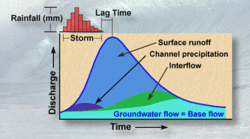
 A river's discharge is defined as the volume of water passing through the cross-sectional area of the channel per unit time. It is a product of channel width, depth and velocity of water (any of which can vary). The total discharge can be separated into components based on the source of the water (i.e., overland flow, channel precipitation, throughflow, groundwater flow). Discharge can be depicted using a hydrograph, which is simply a plot of discharge vs. time. Rainfall and air temperature affect discharge causing it to vary significantly with the seasons. It is high in the early spring because of the release of precipitation stored as ice and snow during the winter. It is low in the summer despite high rainfall because large amounts of water are removed through evaporation and plant uptake (due to high air temperature). Discharge is high again in the fall because there is less evaporation and transpiration, allowing more of the rainfall to go to the river. Discharge is cumulative down a watershed and is accordingly affected by the shape of the drainage basin.
River and Land
 (Source: Biodiversity Institute of Ontario)
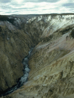
 The dynamic relationship between the river and the land is shaped by the river's fluvial characteristics and involves the interconnected processes of erosion, transportation of materials and deposition.
Erosion
 (Source: Biodiversity Institute of Ontario)
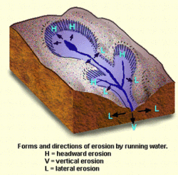
 The materials present in the river are for the most part a product of erosional forces wearing away the land. A river cuts both downwards (vertical erosion) and sideways (lateral erosion) to extend its channel. It may also extend back in the upstream direction through headward erosio]. Four basic types of erosion operate in rivers: corrosion (erosion by chemical action), hydraulic action (i.e., water power), corrasion (the wearing away by abrasion) and crumbling or attrition (the cumulative result of repeated pounding). With all of these forms of erosion working together, even the most massive of rocks can be attacked and demolished over time.
Transportation of Materials
 (Source: Biodiversity Institute of Ontario)
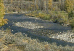
 The transportation of materials (called sediment) is a very important function of river flow. Materials are transported by running water in three principal states: as dissolved matter, as suspended solids, and as the bed load. Large amounts of inorganic ions carried in solution make up the bulk of the dissolved matter (although dissolved organic matter is also an important component). Most of the other substances can be classified as either organic detritus or rocky debris, the latter being called alluvium. The bed load is the fraction of alluvium too large to be carried via suspension; it only rarely moves by rolling, sliding or bouncing during times of increased wtaer volume or velocity. Small alluvial items, such as clay, silt, sand and small pebbles, are carried in suspension and are often visible as "turbidity" (cloudiness). Velocity, turbulence, and the size, shape and specific gravity of a suspended particle determine how long and far it will be carried. The stream's competence indicates the grain size that a current can barely move. In other words, a particle whose size exceeds the stream's competence will be deposited. The stream's capacity is the maximum volume of sediment of a given size that it can transport (any sediment exceeding the capacity will be deposited).
Deposition
 (Source: Biodiversity Institute of Ontario)
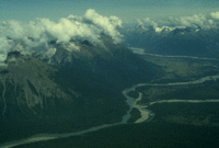
 At the same time that the river is tearing apart the land in some areas, it is rebuilding it in others. The deposition of material downstream reduces roughness in the river bed and banks. Sediment tends to be deposited along a gradient down a river according to particle size. Larger particles such as stones and pebbles are deposited first in the headwater regions, whereas finer particles such as clay and silt are carried further downstream to be deposited in the lowland reaches. Irregular deposition is responsible for many structures common in rivers. Bars, for example, are extended zones of sediment accumulation. Sediment repeatedly deposited during flood events can lead to the formation of natural dikes (raised areas) around a river channel called levees. Rivers with very large alluvial loads may form braided streams where many small channels are formed, separated by elongated bars and islands. Deltas are "alluvial fans" characteristic of rivers depositing a lot of sediment at the river mouth.
River Morphology
 (Source: Biodiversity Institute of Ontario)
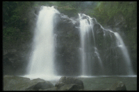
 Erosion and deposition jointly act to fashion the form or "geometry" of the river channel and produce a wide variety of fluvial landforms. The shape of the channel is determined by the bed and bank substrata, the discharge and flow velocity, and the types and amounts of sediments. Irregularities in the profile of rivers, such as rapids and waterfalls, are often due to the presence of rocks of varying hardness in the same area. Water flowing across such an area is able to cut into softer rock much more easily than harder rock, resulting in different rates of erosion. The irregular channel shapes that result affect the water velocity, which in turn can further contribute to fashioning the land (such as the "plunge pool" carved out by the power of a waterfall).
 (Source: Biodiversity Institute of Ontario)
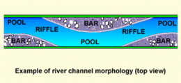
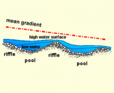
 Many other local irregularities in the profile of the channel have been described. Riffles are shallow regions paved by stones and gravel where the current moves more quickly and with more turbulence. They often alternate with pools, which are slower, calmer and deeper areas with fine-grained bottom deposits. Cascades are steep areas where flow occurs over a sequence of emergent boulders, with each drop known as a step. Such formations are constantly being created and destroyed as a result of the powerful dynamics of a flowing river.
 (Source: Biodiversity Institute of Ontario)
  (Source: Biodiversity Institute of Ontario)
 Meandering Rivers
 (Source: Biodiversity Institute of Ontario)
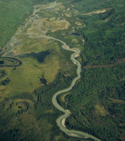
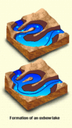
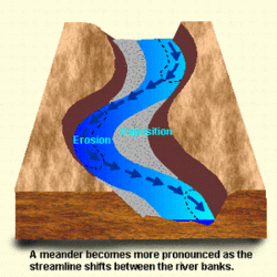
 Straight regions of a river tend to have fairly flat and level bottoms, but few rivers have channels that stay straight for very long. Most travel at least one and a half times further than the linear distance from source to mouth, following a curving path of bends and loops called meanders. These are actually complex formations carved out by the lateral movements of the river flow. A single bend has a concave outer bank where the current is faster and erosion predominates, and a convex inner bank where the slower water deposits more alluvium.
 (Source: Biodiversity Institute of Ontario)
 The complex dynamics occurring as the river moves back and forth within the channel walls creates a range of habitats for the river biota. Sometimes a meander will curve so much that it almost becomes a complete loop. In this case the river will often create a new channel between the beginning and end of the loop, cutting off the meander core and resulting in the formation of an oxbow lake.
Grade
 (Source: Biodiversity Institute of Ontario)
 Although [[erosion], transportation and deposition] all occur simultaneously, rivers are often described by their dominant process. A river that is aggrading is carrying a load greater than its capacity and therefore depositing alluvium to its channel. By contrast, a degrading river is one that is picking up alluvium and thus eroding the channel. A river (or section thereof) that is in dynamic equilibrium between erosional and depositional forces is called graded. No river is graded throughout its profile although all rivers tend towards this state of equilibrium. Remember that along the river continuum headwater streams are often degrading whereas lowland rivers are generally aggrading.
Flooding
 (Source: Biodiversity Institute of Ontario)
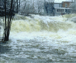
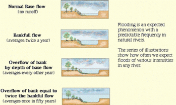
 Our traditional concept of rivers has been heavily influenced by the neat, orderly aqueducts built by Roman engineers. These, however, are very poor models of natural rivers as they involve only the downstream flow of water and fail to account for the importance of lateral movement. Rivers do not stay neatly in defined boundaries: the water/land boundary changes constantly over time in response to the availability of water. This natural phenomena is called flooding (or overbank flow) . We tend to have a biased view of floods as unpredictable, disastrous events, while in reality they are predictable and necessary occurrences.
 (Source: Biodiversity Institute of Ontario)
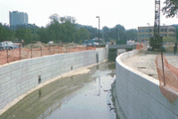
 Denial of this fact leads to poor planning and can result in damaging effects on urban areas and negative ecological consequences. For example, flooding is often more severe in urban areas because water that would normally be stored as groundwater is diverted to the river through storm drainage systems. Channelization (the building of walls to contain the river) can also worsen flooding since increased water speeds during floods (from the smooth channel banks) can cause more damage when the banks are eventually overreached. Channelization may also enhance flood peaks downstream causing damage in unprotected areas. Another problem occurs in fields that have been tile drained for agricultural purposes, since this leads to rapid return of rainwater to the river, increasing its flood proneness.
Source of Flood Waters
 (Source: Biodiversity Institute of Ontario)
  (Source: Biodiversity Institute of Ontario)
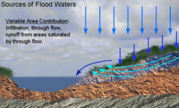
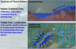
 There are several theories to explain the movement of water from precipitation to river during a flood event. An early theory, called Horton Overland Flow, proposed that the flood peak was due to the overland runoff during a storm. In other words, the soil was quickly saturated and the water then moved across the land to the river channel. This concept was modified with the realization that this kind of runoff is relatively rare. The Partial Area Contribution theory says that only certain small regions of a watershed regularly contribute to overland flow. The Variable Area Contribution theory suggests that water infiltrates the soil and flows to specific areas near a river, such as wetlands. The water then moves from these areas (which are variable in size) to the river by overland flow.
Floodplains
 (Source: Biodiversity Institute of Ontario)
 A river really consists of both the river channel and its floodplain. The latter is a broad, flat area bordering the channel composed largely of alluvium deposited by the river during flooding. In the headwaters of a river the floodplain is poorly developed and flooding is less predictable, whereas in the lowlands flooding is more predictable, the floodplains are better developed and the lateral movements of water are very important. Riparian zones are vegetated areas of the floodplain that have an important influence on the river (such as in nutrient cycling).
Rivers and Dams
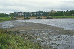
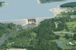
Dams are found throughout the world and there are very few rivers anywhere that have not been affected by them. They are built for several reasons and in various sizes, but are primarily used for flood control and to produce hydroelectric power. A reservoir temporarily holds the flood waters from the dam so that they can be released slowly later, for example to enhance the flow downstream during periods of low flow. Thus, in essence, the dam serves to keep the water level of the river constant. Dam reservoirs are also often used as places of recreation ("man-made lakes"). The regulation of rivers through the use of dams has important ecological effects. For example, organisms adapted to natural seasonal flow changes are adversely affected, the ability of the river to serve as a corridor for species movement is reduced, and the function of the riparian zone as a filter between land and water is reduced.
 (Source: Biodiversity Institute of Ontario)
  (Source: Biodiversity Institute of Ontario)
 The River Mouth
 (Source: Biodiversity Institute of Ontario)
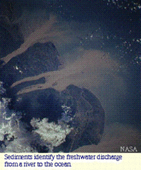
 When the running water of the river meets the standing water of a lake or ocean at the river mouth, a unique environment is created. All the nutrients and sediments from the river are dumped at this interface. In many cases, large formations are created in the form of deltas or estuaries.
Delta
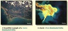
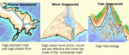
Deltas are created by a buildup of alluvium deposited at the river mouth (the Mackenzie Delta is a good Canadian example). The main river breaks up into smaller streams called distributaries following a pattern that resembles the reverse of the tributary patterns upstream. Deltas occur when a river carrying a high sediment load down a shallow coastal gradient meets a calm sea (or lake). They are extremely dynamic land forming areas: land is formed anew at the foot (seaward) end through the deposition of silt; the river channels are continually shifting, becoming dominant, minor or disappearing; lakes are formed by the isolation of depressions with the advance of the foot of the delta. All of these processes can occur relatively quickly (e.g., in a century). Three factors have enough energy to move significant amounts of sand and thus determine the delta form: river discharge, ocean waves and ocean tides.
 (Source: Biodiversity Institute of Ontario)
  (Source: Biodiversity Institute of Ontario)
 Estuaries
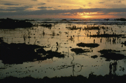
Estuaries are the counterparts of deltas (although the distinction between delta and estuary is not always clearcut, and some rivermouths could be described as combinations of both). They occur at the meeting of freshwater and saltwater when there is a low sediment load, steep coastal slope, strong ocean currents and strong tidal effects (the mouth of the St. Lawrence River is a very good example in Canada). Four types of estuaries can be distinguished on the basis of their origin:
- Drowned river estuaries form on a coastal plain as a result of an increase in sea level (such as happened during the last deglaciation);
- Estuaries may be formed due to tectonic land subsidence;
- They may be formed due to sedimentation and the formation of sand bars enclosing an area against the coastline into which a river flows;
- Certain fiords, which are carved out by glaciers, may have a lip at their mouth rising from the floor of the fiord and causing reduced mixing between river and seawater.
 (Source: Biodiversity Institute of Ontario)
 When freshwater meets saltwater a region of contrasting density currents and fluctuating salinity gradients is created. River water flows out over dense sea water and countercurrents of saline water slide upward into the river mouth. The two types of water mix, creating a diverse and sometimes difficult environment for the organisms there. Some of the highest biotic productivities are seen in estuaries, where the nutrients from the land mix with the seawater minerals. The diversity of niches leads to a complex and unique ecosystem, differing from both the river and sea that contribute to its character.