Petén Veracruz moist forests
Contents
Petén-Veracruz moist forests
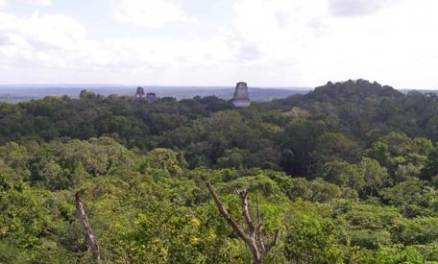
Moist forests pierced by Mayan temples, Tikal, Guatamala. @ C.Michael Hogan
The Petén-Veracruz moist forests is a moist broadleaf forest ecoregion in mostly mountainous terrain that extends through most ofBelize northward through parts of Guatemala and into southern Mexico. This forested ecoregion covers an area of approximately 149,100 square kilometres. Endemism of this ecoregion is moderate, with amphibian endemism particularly notable, and overall species richness is high; vertebrate taxa found here, for example, total 988 species.
This ecoregion is classified as critically endangered due to relentless encroachment of the human population, particularly from the human overpopulated portions of the forests that lie in Guatemala and southern Mexico; conversely, the nation of Belize has kept its population within the land's carrying capacity and has a strong national ethic of environmental protection. The ecoregion is situated within the Tropical and Subtropical Moist Broadleaf Forests biome.
Geographical setting

The Petén-Veracruz moist forests generally extend eastward to the Gulf of Mexico; however where the Pantanos de Centla ecoregion lies along the southern Mexican Caribbean coast, producing an ecological transition to the Gulf frontage. At the south the Petén-Veracruz moist forests are bounded by a broad coastalplain and southern foothills of the Mayan Mountains; the Belizean pine forest ecoregion is established at this southern limit, although much of the pine forest here presents as a savanna. At the northeast limit of the Petén-Veracruz moist forests, this ecoregion is bounded at the north by the Yucatan dry forests in Mexico.
Geology and hydrology
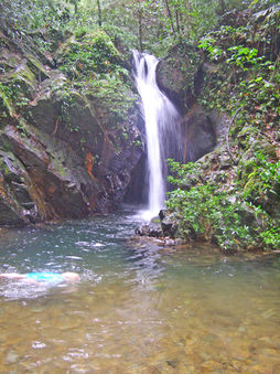 Secluded waterfall, Cockscomb Basin Wildlife Sanctuary. @ C.Michael Hogan Soils within the Petén-Veracruz moist forests are relatively rich in nutrients compared to other tropical regions; this fact may assist in explaining the early advanced civilisations of the Maya people in this area.
There are numerous rivers and lakes within this Neotropical realm ecoregion; in some cases the rivers penetrate limestone karst strata and produce spectacular underwater river caverns. Major southern rivers in the Belize portion of the ecoregion include the Mopan and Macal Rivers; the Macal cuts through dense jungle, and provided the chief transportation link for ancient Mayans in the region.
The Guatemalan portion of the ecoregion holds a number of significant sized lakes; Lake Petén Itzá, for example, is the second largest lake of Guatemala and is the site of a major butterfly reserve.
Flora
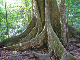 Moist forest of the Maya Mountains, Belize. @ C.Michael Hogan
Common tree species in the Maya Mountains area include Cohune Palm (Attalea cohune), Ironwood (Dialium guianense), Bitterwood (Simarouba amara), Quamwood (Schizolobium parahybum), as well as tree ferns such as Cyathea myosuroides and Cyathea multiflora.
Fauna
Endangered mammal species that are found in this ecoregion include jaguar (Panthera onca), ocelot (Leopardus pardalis) and jaguarundi (Puma yagouaroundi). There are numerous special status taxa that are found in the Peten-Veracruz moist forests ecoregion, denoted variously as Near Threatened (NT), Vulnerable (VU), Endangered (EN), or Critically Endangered (CR).
Birdlife
Numerous bird taxa are found in this ecoregion. The Scarlet Macaw (Ara macao) is found broadly in Central America's moist forests and is well represented in the Maya Mountains and further north in the ecoregion. Another broadly distributed tropical bird found in the ecoregion is the Mealy Parrot (Amazona farinosa), which is one of the largest parrots of the Americas.
Amphibians
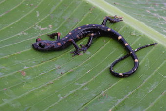 The endangered Nimble Long-limbed salamander. Source: Sean Michael Rovito /EoL A number of anuran species are found in the Peten-Veracruz moist forests, including the ecoregion endemic Godman's Treefrog (Tlalocohyla godmani), found only in northeastern and western Querétaro, northeastern Puebla and Veracruz, southward to south-central Veracruz, Mexico. Another ecoregion endemic frog is the Chiapas Dwarf Robber Frog (Craugastor montanus EN), found only in cloud and mixed forests of Cerro Ovando and surroundings, within the Sierra Madre de Chiapas, Mexico. Another ecoregion endemic is the Oaxacan Fringe-limbed Treefrog (Ecnomiohyla echinata CR), known only to northern slopes of the Sierra de Juárez, in the vicinity of Vista Hermosa, Oaxaca, Mexico. Further, the Maya Mountains Frog (Lithobates juliani) is endemic to the ecoregion, known only to the Maya Mountains within Belize. The Sierra Juarez Robber Frog (Craugastor polymniae) is also endemic to the ecoregion, and is found only known from the vicinity of the town of Vista Hermosa, Sierra de Juárez, north-central Oaxaca, Mexico. Other anurans here include: the Nimble Long-limbed Salamander (Nyctanolis pernix EN), found in pine-oak forest and cloud forest; the ecoregion endemic Adorned Robber Frog (Craugastor decoratus); Alfred's Rainfrog (Craugastor alfredi), a taxon found in this ecoregion at the southern end of its range in western El Peten, Guatemala; Arcane Spikethumb Frog (Plectrohyla sagorum EN), a stream breeder found chiefly in cloud forest; and Blue-spotted Mexican Treefrog (Smilisca cyanosticta NT).
The Black Jumping Salamander (Pseudoeurycea nigra), endemic to the Peten-Veracruz moist forests ecoregion, is found only on the Caribbean versant of the northern highlands region of Chiapas, Mexico. Another salamander endemic to the ecoregion is the Sierra Juarez Moss Salamander (Cryptotriton adelos), found on the Atlantic versant of the Sierra de Juarez, Pena Verde, and at Sierra de Mazateca on the Guelatao-Vista Hermosa transect, north-central Oaxaca, Mexico. The Black-spotted False Salamander (Pseudoeurycea nigromaculata CR) occurs at only two locales in southern Veracruz, Mexico: the peak of Cerro Chicahuaxtla, Cuatlalpan and on Volcán San Martín.
Reptiles
The ecoregion boasts numerous reptiles, including one of the world's most venomous snakes, the Fer-de-lance (Bothrups asper); this species is both aggressive and highly lethal, with an unusually vivid sexual dimorphism, the female displaying much greater size than the male. A reptilian endemic to the ecoregion is the Tehuantepec Hooknose Snake (Ficimia variegata), known only to Isthmus of Tehuantepec, in Mexico; another ecoregion endemic is the Veracruz Graceful Brown Snake (Halopeltis cuneata). A number of lizards also inhabit the ecoregion, including the rather common lizard of the ecoregion that also occurs in neighbouring dry forests, the Brown Basilisk (Basiliscus vittatus); this olive brown species is noted for the male’s large flaplike crest that is supported by flexible cartilage. A more notable lizard of the Atlantic slopes of the ecoregion is Hernandez’s Helmeted Basilisk (Corytophanes hernandezii); this reddish brown reptile typically sits quietly with its cryptic colouration to avoid predation. The Yucatan Banded Gecko (Coleonyx elegans) is the only gecko of the region with well developed eyelids; this gecko is entirely terrestrial, where he forages for small arthropods among the moist forest floor litter.
Basis of ecoregion delineation
This ecoregion has been designated by the World Wildlife Fund as unit NT0154, although caution should be used in consulting their database since they have used the ecoregion name in some places interchangeably with the separate ecoregion of Veracruz moist forests.
Mayan prehistory
Thousands of years before the present, Mayan settlers migrated from the north (present day Guatemala). These early peoples developed a highly sophisticated civilisation in cities at the edge throughout the forests of this ecoregion, in the foothills of the Mayan Mountains and northward. Ruins of such cities as Tikal, Lubaantun and Nim li Punit are visible today, as testaments to the architectural skills of these stone builders; other more obscure sites such as Chaa Creek remain unexcavated. One of the chief methods of Mayan travel were travel routes for water based trade with their ancestral tribes to the north. These Mayans were skillful canoers, and made use of the low gradient rivers descending from the Mayan Mountains as they reached discharge to the sea. After the river journey, they would continue on by sea to reach the northern lands, where they traded pottery and agricultural commodities. In addition, rivers entirely within the ecoregion such as the Macal River were used for transport for Mayan cities along that waterway.
References
- Jonathan A.Campbell. 1999. Amphibians and Reptiles of Northern Guatemala, the Yucatan, and Belize. University of Oklahoma Press. 400 pages
- Gonzalo Castro and Ilana Locker. 2000. Mapping conservation investments: an assessment of biodiversity funding in Latin America and the Caribbean. Biodiversity Support Program. 79 pages
- C.Michael Hogan. 2007. Lubaantun. The Megalithic Portal. ed. A.Burnham
- Roger Tory Peterson, Edward L. Chalif. 1999. A Field Guide to Mexican Birds: Mexico, Guatemala, Belize, El Salvador. Houghton Mifflin Harcourt. 320 pages
| Disclaimer: This article contains some data that was originally promulgated by the World Wildlife Fund. Topic editors and authors for the Encyclopedia of Earth have edited such content and added new information. The use of information from the World Wildlife Fund should not be construed as support for or endorsement by that organization for any new information added by EoE personnel, or for any editing of the original content. |